The Basin By/Ollomont opens in semicircular shape above the Commons of Allein, Doues, Valpelline and Ollomont, contained in the West Buttress from South coming from the Mont Velan (3.734m) forming successively Faceballa Heads, those of Faudery, The Salliousa, Tête de Crete, Mont Chenaille and to Mont Saron just above Allein Municipality. In the North however, the limit is set by the ridge border between Italy and Switzerland that the same goes with different Summit with the East-northeast ridge to Col de Valsorey (3.107m), beyond which reaches the Grand Tête de By (3.588m) and the important Fenêtre de Durand (2.803m). And from this again to the South part of the Mont Gelé (3.518m) the Eastern part that, after forming the largest Chain of Morions, reaches the elegant Punta Cesare Fiorio (3.332m) and then finally declined towards Ollomont and Valpelline Communes. So this basin can be divided into three specific sectors:
1) - the Western sector totally devoid of lakes, if not a tiny Lake in Champillon.
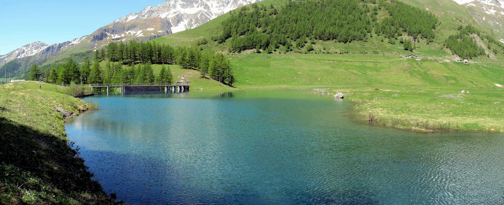
2) - the large Northern area where you place the small artificial lake of By (1.987m), the immediately above Lac de By (2.167m), a pond under the Molars Valsorey and the Northeast end Fenêtre below Lac (2.711m) in Mont Avril and Mont Gelé.
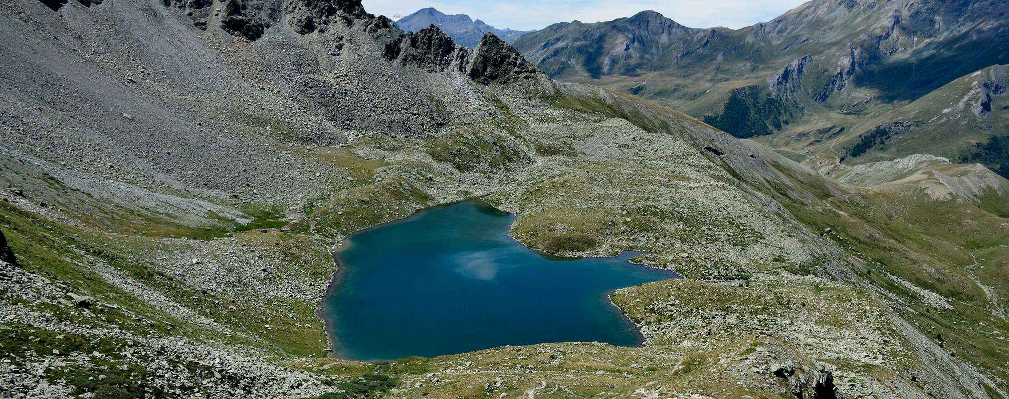
3) - the Eastern area dotted with numerous lakes that end with those of Cornet below Mount Berrio.
This tour is addressing these with visit of all to the Fenêtre Durand and going down towards to By then return always to Ollomont.
La Conca di By/Ollomont s'apre in forma semicircolare al di sopra dei Comuni di Allein, Doues, Valpelline ed Ollomont, contenuta ad Occidente dal Contrafforte Meridionale che proviene dal Mont Velan (3.734 m) formando in successione le Teste di Faceballa, quelle di Faudery, La Salliausa, Tête de Crete, Mont Chenaille e fino al Mont Saron sopra Allein. A Settentrione invece il limite è stabilito dalla cresta di frontiera tra Italia e Svizzera che dal medesimo scende con diverse Sommità con la cresta Est-nordest al Col de Valsorey (3.107 m), oltre la quale raggiunge la Grand Tête de By (3.588 m) e l'importante Fenêtre de Durand (2.803 m). Da questa e nuovamente verso Sud parte dal Mont Gelé (3.518 m) il divisorio Orientale che, dopo avere formato la grande Catena dei Morions, raggiunge l'elegante Punta Cesare Fiorio (3.332 m) per poi definitivamente declinare verso Ollomont e Valpelline. Quindi questo bacino può essere diviso in tre specifici settori:
1) - il settore Occidentale del tutto privo di laghi, se non un minuscolo laghetto a Champillon.
2) - la larga area Settentrionale nella quale si colloca il piccolo lago artificiale di By (1.987 m), l'appena soprastante Lac de By (2.167 m), un laghetto sotto i Molari di Valsorey ed all'estremità Nordest il Lac Fenêtre (2.711 m) sottostante a Mont Avril e Mont Gelé.
3) - la zona Orientale disseminata da numerosi laghi che si concludono con quelli del Cornet al di sotto del Monte Berrio.
Questo Tour si rivolge proprio a questi ultimi con visita di tutti fino alla Fenêtre Durand e passando in discesa verso quello di By per poi rientrare sempre ad Ollomont.
Getting There
BY CAR:
From TORINO, MILANO, etc: Motorway A5. Exit at Aosta East
From FRANCE: through the Mont Blanc Tunnel to Entrèves/Courmayeur. By Little Saint Bernard Pass, closed since November until half May to La Thuile Valley - Pré Saint Didier - AOSTA Municipalities. It is not necessary to take Motorway A5: you can drive on SS.26, in the direction of AOSTA - IVREA - TURIN.
BY PLANE:
Aeroporto "Corrado Gex" Saint Christophe (Aosta).
Specific Road
From Aosta East exit of the motorway, follow along the SS.27 for the Gran San Bernardo Tunnel After about ten Km turn to the right toward Valpelline (964m), creoss it and turn to the left to get Ollomont (1.335m) and the small built area of Glacier (1.549m), where you must start walking.
Dall'uscita del Casello Autostradale di Aosta Est, proseguire sulla SS.27 in direzione del tunnel del Gran San Bernardo; dopo circa un decina di chilometri svoltare sulla destra verso il Paese di Valpelline (964 m). Dopo averlo superato svoltare sulla sinistra e raggiungere il Paese di Ollomont (1.335 m); proseguire sino alla Frazione di Glacier (1.549 m), dove inizia l'itinerario a piedi.
Approach and Route
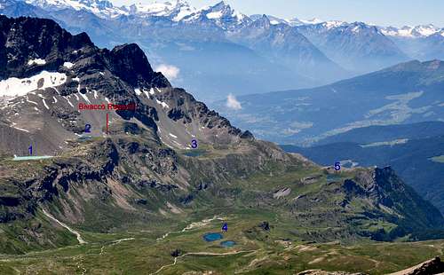
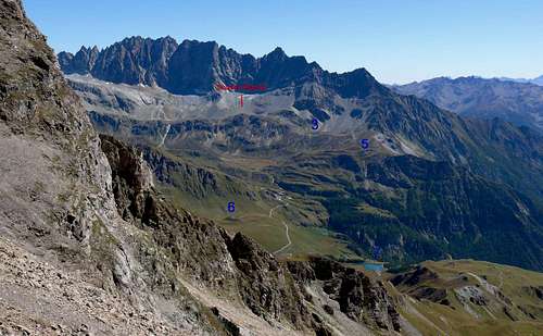
From the village of Glacier (1.562m), reached by the Regional Road from Ollomont, take path n° 6 that, over the bridge at a wooden fountain, rises to the Alp Crottes and reaching the Oratory of Gaula (1.591m; 1.863m); from this, flexing more toward the Northeast is reached to Planet (2.150m) at the entrance of the "Comba des Eaux Blanches". At the next junction at 2.220 meters, at the Torrent Fenetre, he leans toward Southeast coming to the Col Cornet and Lake (2.334m, 2.355m), encountering the trail n° 6/7/Alta Via n° 1 which dates directly from Ollomont-Croux (1.330m) and with which we reach, after bypassing the Lago dell'Icliousa (2.420m) below Tête Bonin the Bivouac Nino Regondi (2.599m; E/F; 3h'00/3h'30), located between the Lago Leytou (2.538m) and the Lago Benseya (2.513m) as well as below the Mont Clapier (3.437m). Discarding the upper right two other lakes (2.590 meters and 2.508 meters) go down, always through the path n° 6, towards the North to the junction 2.347 meters and with a small path not numbered, after a brief and easy-end and rocky forded the Torrent Fenêtre, you reach Alpe Thoules (2.381m). From this point we have three options:
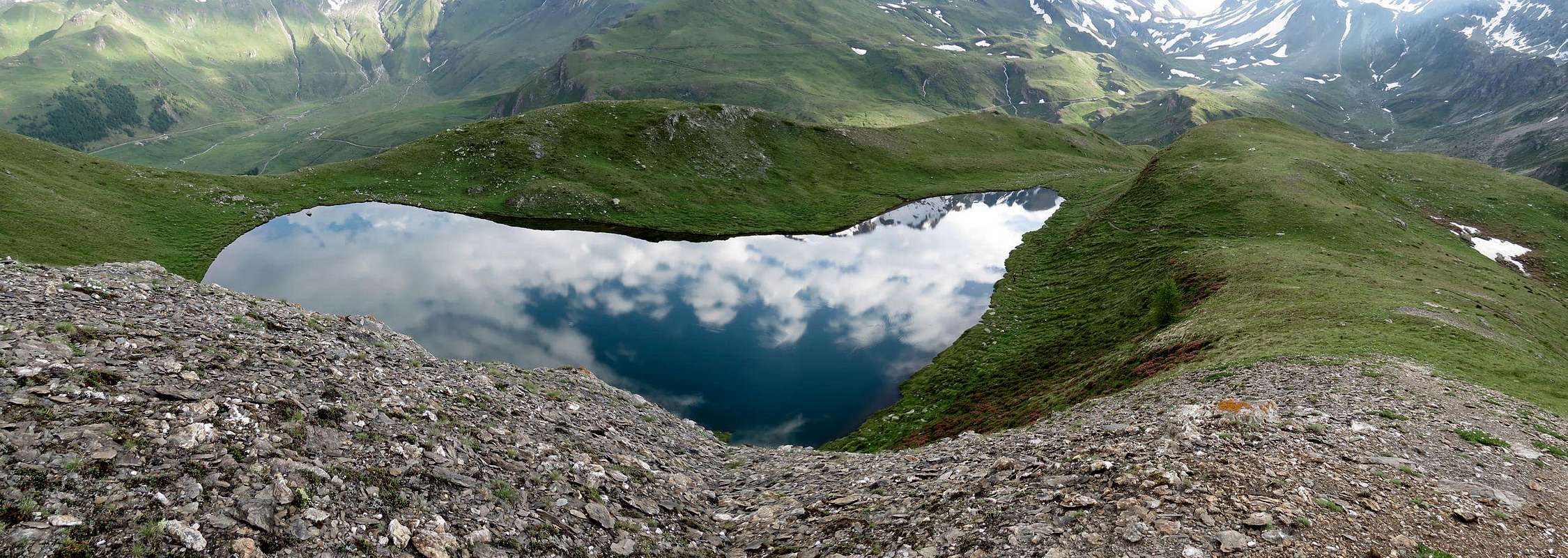
1)- continue on the valley floor with the trail n° 5/TdC until, after a zone of large blocks followed by a long diagonal, the Lac Fenêtre and the Fenêtre Durand (2.711m, 2.803), located between the Mont Avril and Mont Gelé (1h'15/1h'30).
2)- back down with the farm dirt road, concomitant with the previous path to Alpe Balme de Bal (2.128m) after having exceeded that of Lambardin (2.309m); from this short ascent on trail unnumbered reach the path n° 6 at the junction at 2.220 meters. Do not follow the same but, leaving him on the left, continue with the previous noon always returning to the Lake and the Col Cornet. This way you can make the descent to Ollomont-Cognen, through the Pastures Tsa de Berrio (2.165m), Berrio Damon (1.982 m) and Dèsott.
3)- from the Balme de Bal Pastures continue with two more diversified opportunities:
a)- down by directly with a shortcut unreserved reaching the small bridge 2.090 meters on the Torrent des Eaux Blanche, under the Alp Planet (2.150m), and then the initial route to the Oratory of the Gaula and the Village of Glacier.
b)- wanting to expand the tour to the West, down to the middle of the estate road always coincide with the route n° 5/TdC up to the Farinet House at the Artificial Lake 1.987 meters; from this point and at the location "Cheval Blanc" return to Glacier Hamlet with the trail n° 3/4/5 passing through the Alps Crottes (1.733m) and Pont (1.690m).
Variant: from the farm dirt road at the junction immediately before the House Farinet a short detour to the North leads with unnumbered path to the nearby Lac de By (2.167m).
SCHEDULE of DRIVING Calculate the 6h'00 to 7h'00 for the ride overall, increasing to 2h'30/3h'00 wanting reach from the Alps Thoules the Lac Fenêtre and the Fenêtre Durand, round trip.
Dal Villaggio di Glacier (1.562 m), raggiungibile con la Strada Regionale da Ollomont, prendere il sentiero n° 6 che, oltrepassato il ponte presso una fontana in legno, sale verso l'Alpeggio di Crottes raggiungendo l'Oratorio della Gaula (1.591 m; 1.863 m); da questo, flettendo maggiormente in direzione Nordest si raggiunge quello di Placet (2.150 m) all'ingresso della "Comba des Eaux Blanches". Al successivo bivio 2.220 metri, presso il Torrent Fenêtre, si piega verso Sudest arrivando al Lago ed al Col Cornet (2.335 m, 2.355 m) incontrando il sentiero n° 6/7/Alta Via n° 1 che risale direttamente da Ollomont-Croux (1.330 m) e con il quale si raggiunge, dopo avere sorpassato il Lago dell'Icliousa (2.420 m) al di sotto della Tête Bonin, il Bivacco Nino Regondi (2.599 m; E/F; 3h'00/3h'30), collocato tra il Lago di Leitou (2.538 m) ed il Lago Benseya (2.513 m) nonché al di sotto del Mont Clapier (3.437 m). Scartando in alto a destra altri due laghetti (2.590 metri circa e 2.508 m) si scende, sempre tramite il sentiero n° 6, verso Settentrione fino al bivio 2.347 metri e con un piccolo sentiero non numerato, superata una breve e facile fascia rocciosa e guadato il Torrent Fenêtre, si raggiunge l'Alpe di Thoules (2.381 m). Da questo punto sono possibili tre soluzioni:
1) - continuare sul fondovalle con il sentiero n° 5/TdC fino a raggiungere, dopo una zona di grandi blocchi seguiti da un lungo diagonale, il Lac Fenêtre e la Fenêtre Durand (2.711 m, 2.803 m), collocati tra il Mont Avril ed il Mont Gelé (1h'15/1h'30).
2) - rientrare scendendo con la strada poderale, concomitante con il precedente sentiero, fino all'Alpe Balme de Bal (2.128 m) dopo aver oltrepassato quella di Lombardin (2.309 m); da questa con breve risalita su sentiero non numerato raggiungere il sentiero n° 6 presso il bivio 2.220 metri. Non seguire il medesimo bensì, lasciandolo sulla sinistra, continuare verso Mezzogiorno sempre con il precedente ritornando al Lago ed al Col Cornet. In questa maniera si può effettuare la discesa verso Ollomont-Cognen, passando per gli Alpeggi Tsa de Berrio (2.165 m), Berrio Damon (1.982 m) e Dèsott.
3) - dall'Alpe Balme de Bal continuare con altre due diversificate opportunità:
a) - scendere direttamente con una scorciatoia non numerata arrivando al piccolo ponte 2.090 metri sul Torrent des Eaux Blanche, sotto l'Alpe Placet (2.150 m), e quindi all'itinerario iniziale verso l'Oratorio della Gaula ed il Villaggio di Glacier.
b) - volendo allargare il giro ad Occidente, scendere per mezzo della poderale sempre in concomitanza con il sentiero n° 5/TdC fino a raggiungere la Casa Farinet presso il Lago Artificiale 1.987 metri; da questo punto e presso la località "Cheval Blanc" rientrare a Glacier con il sentiero n° 3/4/5 passando attraverso le Alpi Crottes (1.733 m) e Pont (1.690 m).
Variante: dalla poderale, al bivio immediatamente prima della Casa Farinet una breve deviazione verso Nord conduce con sentierino non numerato al soprastante Lac de By (2.167 m).
ORARIO di PERCORRENZA Calcolare dalle 6h'00 alle 7h'00 per il giro complessivo, incrementando di 2h'30/3h'00 volendo raggiungere dall'Alpe Thoules il Lac Fenêtre e la Fenêtre Durand, in andata e ritorno.
Difficulty
This route can be considered E/F or EE/F+ (Experts Hikers).
L'itinerario è da classificare in E/F oppure in EE/F+ (Escursionisti Esperti).
Essential Gear
For High Hiking gear.
Da Alto Escursionismo.
Huts
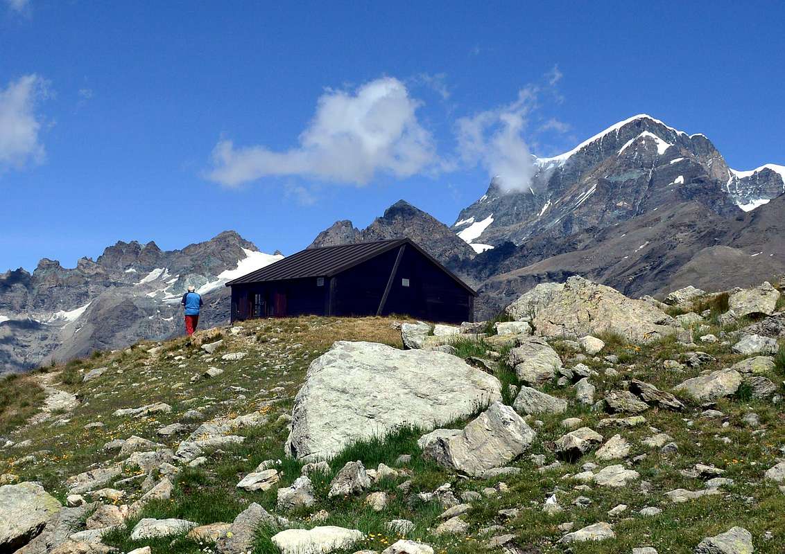
Fixed Bivouac Regondi Gavazzi (2.650m), Difficulty: E (Hikers).
Bivacco fisso Regondi Gavazzi (2.650 m), Difficoltà: E (Escursionisti).
Parents refers to a larger category under which an object falls. For example, theAconcagua mountain page has the 'Aconcagua Group' and the 'Seven Summits' asparents and is a parent itself to many routes, photos, and Trip Reports.

 3834 Hits
 83.1% Score
 16 Votes