
-
 1793 Hits
-
 79.04% Score
-
 10 Votes
|
|
Route |
|---|---|
|
|
45.81639°N / 7.77725°E |
|
|
Hiking |
|
|
E/F |
|
|
Overview
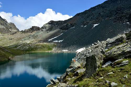
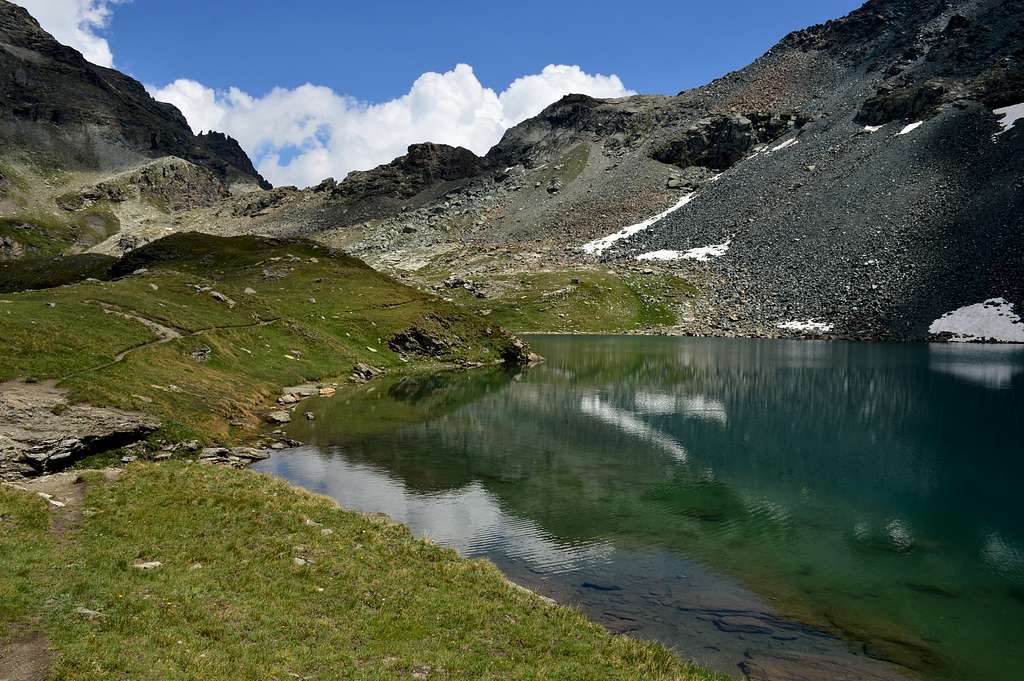
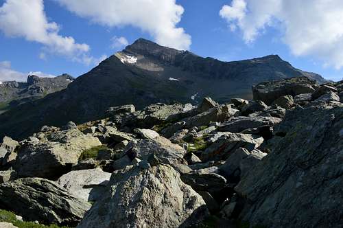
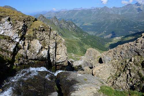
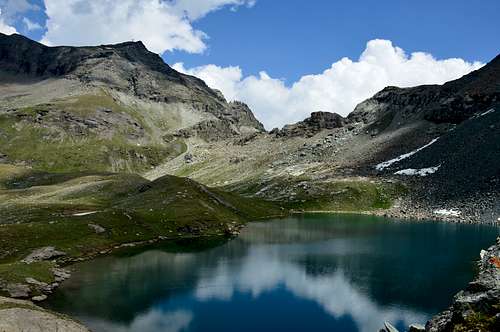
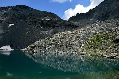
This trio of lakes is located on the slopes of Péntecoll or Colle Pinter (2.776m), located between the Gressoney Valley and the Ayas Valley. More precisely in the North between Mount Pinter or Péntespetz (3.113 meters, with the Lateltin Bivouac nearby), a large shoulder South of Testa Grigia (3.316m), and Corno Vitello or Chalberhòre (+; 3.057m) in the South. They are generally visited during the ascent to the first of these two peaks, but also after a simple but fascinating crossing between the two adjacent valleys to the East and West (Val d'Ayas). The abundant signage, present on both fronts, favors the route which, moreover, if desired, in the Western part is "shortened" by the presence of a cable car that from Champoluc (at 1.592 meters) climbs in the first section to the Station of Crest (1.989m) whence we head to the Village of Cunéaz (2.062m). Or you can continue on the second section, which leads to Ostafaz Damon Station (2.416m). In this second case it is then necessary to reconnect towards the Southeast via path n° 12, which arrives at the crossroads just below Colle Pinter. The environment is idyllic and quite panoramic, but only towards the West, because the watershed between the two valleys, even if only slightly in height, precludes the view towards the East.
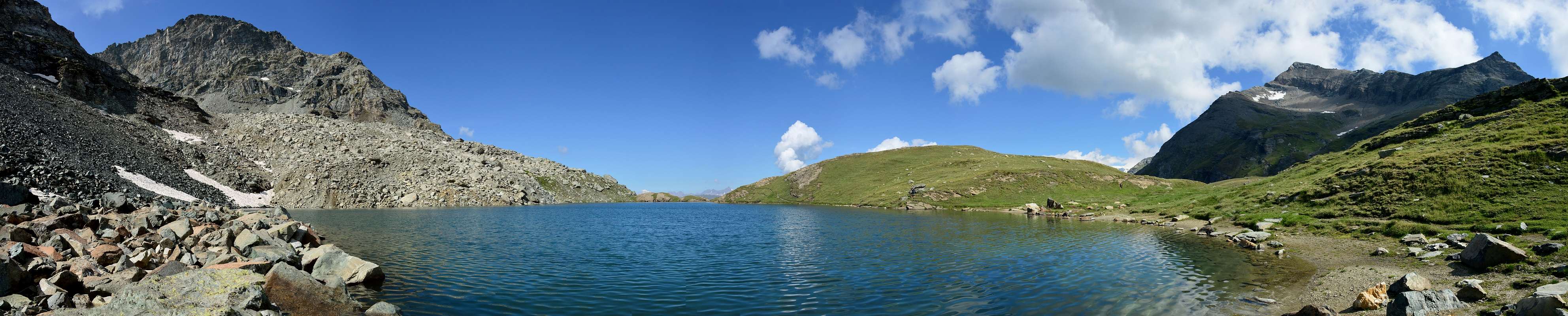
Questo trio di laghetti si trova alle pendici del Péntecoll oppure Colle Pinter (2.776 m), posto tra la Valle di Gressoney e la Valle di Ayas. Più precisamente a Settentrione tra il Monte Pinter oppure Péntespetz (3.113 metri con nei pressi il Bivacco Lateltin), grosso spallone a Sud della Testa Grigia (3.316 m), ed il Corno Vitello oppure Chalberhòre (+; 3.057 m) a Meridione. In genere vengono visitati durante l'ascensione alla prima di queste due Cime, ma anche dopo semplice ma affascinante traversata tra le due vallate adiacenti ad Est ed Ovest (Val d'Ayas). L'abbondante segnaletica, presente su entrambi i fronti, favorisce il percorso che, inoltre volendo, nella parte Occidentale é "accorciato" dalla presenza di una funivia che da Champoluc (in località 1.592 metri) risale nel primo tratto al Crest (1.989 m) donde ci si dirige al Villaggio di Cunéaz (2.062 m). Oppure si può proseguire sul secondo troncone, che conduce alla Stazione di Ostafaz Damon (2.416 m). In questo secondo caso, però, bisogna poi ricollegarsi verso Sudest tramite il sentiero n° 12, che arriva al bivio proprio al di sotto del Colle Pinter. L'ambiente é idilliaco ed abbastanza panoramico, ma solo verso Occidente, perchè lo spartiacque tra le due vallate, anche se di poco in altezza, preclude la vista verso Oriente.
Getting There
- Getting in Gressoney Saint Jean or Gressoney La Trinitè or Champoluc From Torino or Milan: Motorway A5, exit in Pont Saint Martin. Follow Val di Gressoney direction or alternatively exit Verrès and follow the Val d'Ayas direction.
- From Switzerland (Tunnel or Grand Saint Bernard Pass): in Aosta Est, get into Motorway A5. Follow Torino direction, exit from A5 in Pont Saint Martin, follow Val di Gressoney direction or alternatively exit Verrès and follow the Val d'Ayas direction.
- From France (Tunnel Mont Blanc or Petit Saint Bernard Pass): get into Motorway A5, follow Torino direction, exit from A5 in Pont Saint Martin, tell a couple of bad words to the man in the box for the huge motorway fee, and follow for Val di Gressoney direction or alternatively exit Verrès and follow the Val d'Ayas direction.
Roads Route
Specific Roads to Gressoney and Ayas Valleys
Route 1: "La diretta" park the car in Gressoney la Trinitè, and look for a shop called "Alimentari Welf". Very close to this shop there is the headtrail. Route 2, "Ondre Castel, Pinter", Gressoney Saint Jean: at Km 31 of Val di Gressoney Road, there is a little park, close to a garbage collector. 50 meters under this little parking there is headtrail ("Colle Pinter" indication on yellow panel). It is possible to begin this route from Chamonal Hamlet (km 28,8 of Val di Gressoney road). It's a little big longer, but a visit to the typical Village of Alpenzu Grande (1.779m) will satisfy your curiosity for old Walser architecture. People interested in Champoluc destination, follow the same instruction as before changing Pont Saint Martin Municipality with that of Verrès (exit from A5), and follow Val d'Ayas direction, reaching before the Brusson's Municipality and after, proceding through other several hamlets, Champoluc's Municipality.
Itinerario 1: "La diretta" parcheggiare l'auto a Gressoney la Trinitè, e cercare un negozio chiamato "Alimentari Welf". Molto vicino a questo negozio trovasi l'inizio del percorso. Itinerario 2, "Ondre Castel, Pinter", Gressoney Saint Jean: al Km 31 della Strada della Val di Gressoney, c'è un piccolo parco, vicino a un netturbino. 50 metri sotto questo piccolo parcheggio c'è una cosiddetta "testata di viaggio" od inizio del tragitto da effettuare (indicazione "Colle Pinter" su pannello giallo). E' possibile iniziare questo percorso dal paese di Chamonal (km 28,8 della strada della Val di Gressoney). È un po' più lungo, ma una visita al tipico Villaggio di Alpenzu Grande (1.779m) soddisferà la vostra curiosità per l'esistenza dell'antica architettura Walser. Per chi fosse interessato alla destinazione Champoluc, seguire le stesse indicazioni di prima di cambiare destinazione dal Comune di Pont Saint Martin con quello di Verrès (uscita A5), nonché seguire la direzione per la Val d'Ayas raggiungendo dapprima il Comune di Brusson e, dopo altre varie frazioni intermedie, il Comune di Champoluc.
 |
 |
 |
 |
Approaches & routes from Champoluc or Gressoney St. Jean
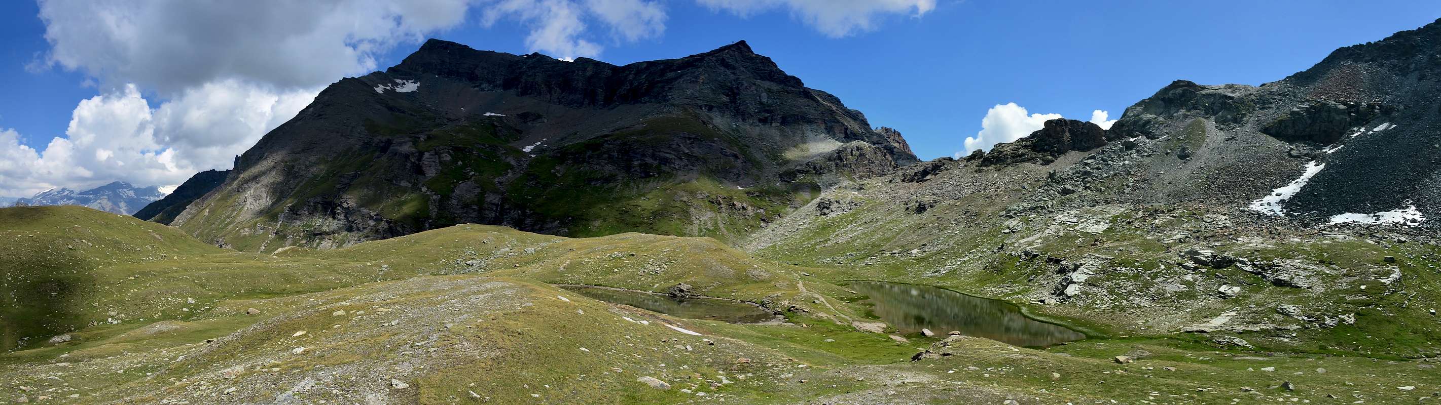
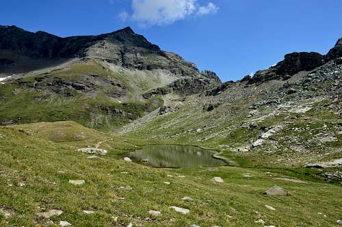
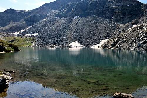
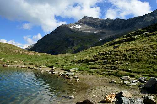
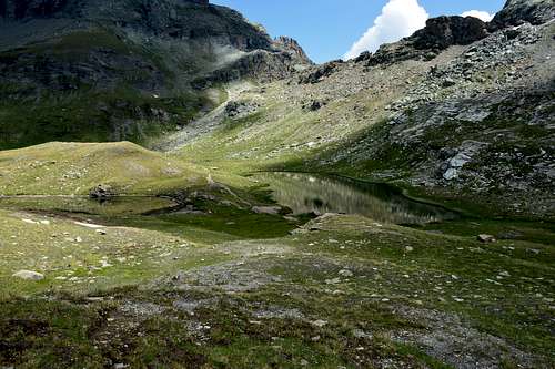
Approaches A)-: From Champoluc Municipality in middle Val d'Ayas you can reach the location of Ostafa cable car station with the path n° 13, or using the cable car. Go down briefly to take the path n° 12. Follow the path winding along the slope with moderate ascent and finally reach the Alta Via n° 1 just before the detour to the right to the Pinter Lakes. At an altitude of about 2.715 meters, leave the Alta Via and turn right (South) to take a small path that with a long diagonal more towards the Southwest reaches first the Lacs de Pénté (2.689m; Pinter Lakes) and then wanting to continue the excursion, with a modest descent, Lake Perrin (2.633m) just below the homonymous hill (2.649m; here you can also reach it with a previous deviation at an altitude of 2.160 meters around which, via trail n° 13, passes towards Alpe Pian Long 2.179 meters).
A)-: Dal Comune di Champoluc in media Val d'Ayas si può raggiungere la stazione della funivia in località Ostafa con il sentiero n° 3, o utilizzando la funivia. Scendere brevemente per prendere il sentiero n° 12. Seguire il sentiero che si snoda lungo il pendio con moderata salita e raggiungere infine l'Alta Via n° 1 appena prima della deviazione a destra per i Laghi di Pinter. A quota 2.715 metri circa abbandonare l'Alta Via, e piegando a destra (Sud) prendere un sentierucolo che con lungo diagonale maggiormente verso Sudovest raggiunge dapprima i Lacs de Pé (2.689 m; Laghi Pinter) e poi volendo proseguire nell'escursione, con modesta discesa, il Lago Perrin (2.633 m) appena al di sotto dello omonimo colle (2.649 m; qui si giunge anche con una precedente deviazione a quota 2.160 metri che tramite il sentiero n° 13, passa verso l'Alpe Pian Long 2.179 metri).
 |
 |
 |
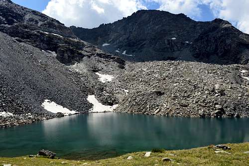 |
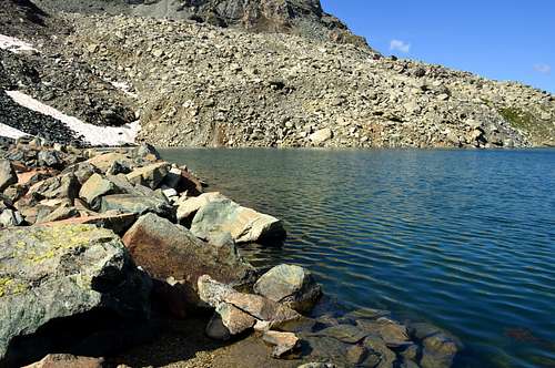
B)-: From the Municipality of Gressoney Saint Jean, on the Regional Road between the two Hamlets of Torre and Order Perletoa, the path n° 6/GSW/Alta Via n° 1, starts from the crossroads 1.420 meters towards the Northwest, which, passing through the Alpenzu Refuge (1.780m), and the Pastures of Héerdhuffe (1.992m), Ondermònté (1.953m), Loaoche (2.363m) and the Alps of Pénte (2.465m) reaches the Péntecoll or Colle Pinter (2.776m), located between the Gressoney Valley and the Ayas Valley. A short descent on the path n° 13, not numbered and almost a track leads to the NE shore of Lake Pinter di Mezzo (of Middle; about 2.690/2 meters); from this with a path always n° 13, not numbered but more evident you pass near the tiny Northern Lake and the larger or Southern one (2.689m). As in the previous itinerary, if you want to continue the excursion, in a short time and climbing over the 2.684 meters little saddle, located at the end of the NW Ridge of Corno Vitello or Chalberhòre (+; 3.057m), you can reach the Lac Perrin (2.633m).
B)-: Dal Comune di Gressoney Saint Jean, sulla Strada Regionale in mezzo alle due Frazioni di Torre ed Order Perletoa, dal bivio 1.420 metri parte verso Nordovest il sentiero n° 6/GSW/Alta Via n° 1, che, passando per il Rifugio dell'Alpenzu (1.780 m), e le Alpi Héerdhuffe (1.992 m), Ondermònté (1.953 m), Loaoche (2.363 m), Pénte (2.465 m) raggiunge il Péntecoll oppure Colle Pinter (2.776 m), posto tra la Valle di Gressoney e la Valle di Ayas. Una breve discesa su sentierino n° 13 non numerato e quasi una traccia conduce alla sponda NE del Lago Pinter di Mezzo (2.690/2 metri circa); da questo con un sentiero sempre n° 13, non numerato ma più evidente si passa nei pressi del minuscolo Lago Settentrionale e del più grande o Meridionale (2.689 m). Come nell'itinerario precedente, volendo continuare nell'escursione, in breve tempo e scavalcando la sella 2.684 metri, posta al termine della Cresta NO del Corno Vitello oppure Chalberhòre (+; 3.057 m), si raggiunge con percorso sempre più indirizzato verso SO il Lac Perrin (2.633 m).
 |
 |
 |
 |
Difficulty
The route can be classified as E/F.
L'itinerario è classificato E/F.
Equipment
Hiking gear.
Da escursionismo.
External Links
- REGIONE AUTONOMA VALLE D'AOSTA the official site.
- FONDAZIONE MONTAGNA SICURA Villa Cameron, località Villard de la Palud n° 1 Courmayeur (AO) Tel: 39 0165 897602 - Fax: 39 0165 897647.
- A.I.NE.VA. (Associazione Interregionale Neve e Valanghe).