-
 854 Hits
-
 79.04% Score
-
 10 Votes
|
|
Route |
|---|---|
|
|
45.66645°N / 7.79383°E |
|
|
Hiking |
|
|
E/F |
|
|
Overview
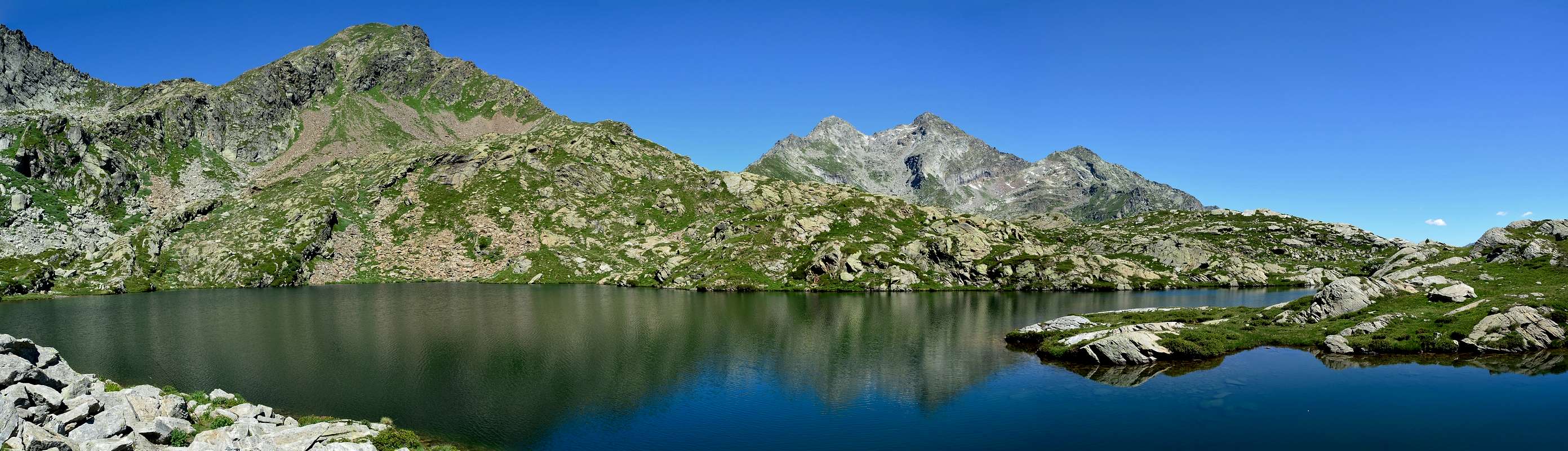
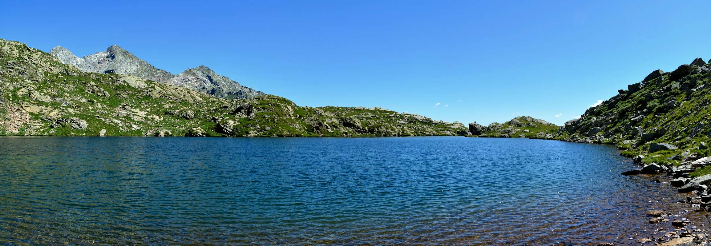
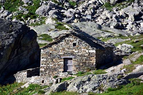
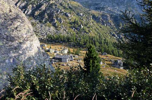
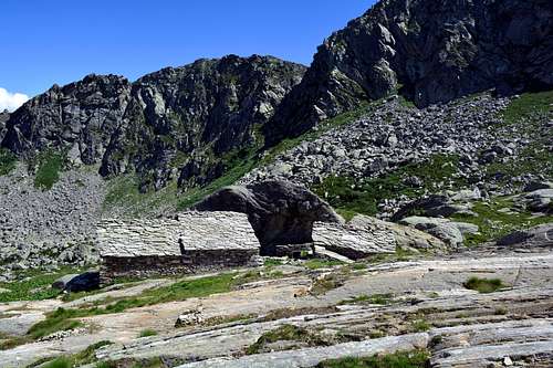
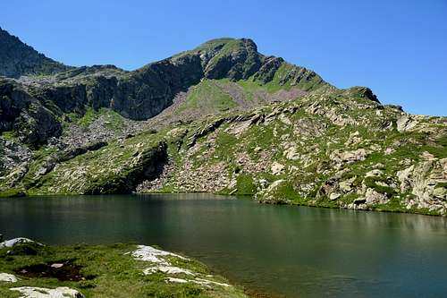
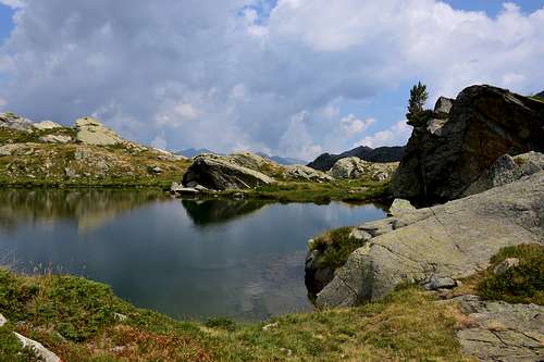
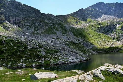
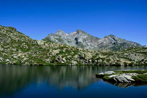
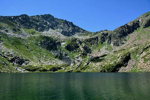
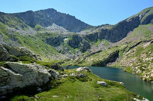
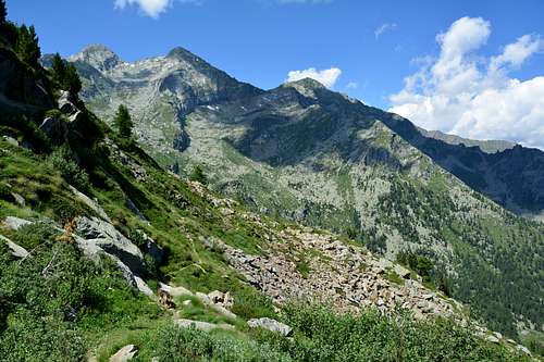
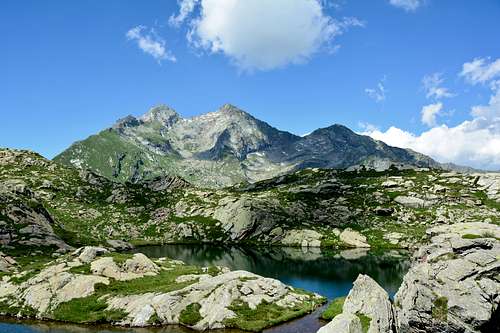
This is the Pic des Allemands (2.747m) or Punta o Corno del Lago also so known by the locals inhabitants as Summit, taht results above the four small lakes in lower Gressoney Valley and above the Municipality of Issime (953/80m), which Mont Crabun is the large shoulder South, before the partition runs out on the Central Valley toward the Baltea Stream. This last is formed by a Summit that it consists of three crests and as many sides, of which the South is directed South to the Col de l'Arche and the Summit of Pietre Bianche (2.413m, 2.432m), after which the ridge declines towards the Croix de Corma above Municipality of Pont Saint Martin at the end of the Valley of Aosta. The other two crests are directed to the North to the Corno del Lago (Horn Lake) and East in the direction of Cima di Prial (2.424m). It has at its Summit and almost at the end of a small East Crest a refuge (2.680m; sleeps six) immediately below the large cross placed on the Top. From its summit beautiful and unusual views of the Central Valley of the Dora, on the Eastern part of Graian and the nearby entrance to the Valley of Gressoney (Perloz, Lillianes, Fontainemore and Issime Villages or Commons), while on the other side overlooking the Valley of Challand. These somewhat neglected mountains, on the other hand, become important by visiting this small basin that expands at the foot of the Dames de Challand, Becca di Vlou (3.032m) and Becca Torché (3.016m), in the North and from Col Dondeuil (2.338m) to Mont Crabun in the West, enclosing this series of lakes located in one place. as pleasant as it is quietIf these are "The Kings", the small lakes at their feet constitute "The Handmaids", who gaze with their blue eyes.
Questo é il Pic des Allemands (2.747 m) oppure Punta o Corno del Lago od anche localmente così conosciuta quale Vetta, che risulta soprastante i quattro piccoli Laghi nella parte inferiore della Valle di Gressoney ed al di sopra del Comune di Issime (953/80 m), della quale il Mont Crabun non costituisce che la grande spalla Meridionale, prima che il divisorio si esaurisca sulla Valle Centrale della Dora Baltea. Questo ultimo risulta formato da tre creste ed altrettanti versanti, delle quali quella Sud si indirizza a Sud verso il Passo de l'Arche e la Cima di Pietre Bianche (2.413 m, 2.432 m), oltre il quale il crinale declina verso la Croix de Corma al di sopra del Comune di Pont Saint Martin al termine della Valle di Aosta. Le altre due creste sono indirizzate a Settentrione verso il Corno del Lago ed a Est in direzione della Cima di Prial (2.424 m). Possiede presso la sua Cima e quasi al termine della Cresta Orientale un piccolo rifugio (2.680 m; sei posti letto) subito sottostante alla grande Croce posizionata sulla Vetta. Dalla sua Sommità belle ed inconsuete vedute sulla Valle Centrale della Dora, sulla parte più Orientale delle Alpi Graie e sul vicino ingresso nella Valle di Gressoney (Villaggio di Perloz e Comuni di Lillianes, Fontainemore ed Issime), mentre sul lato opposto domina la Valle di Challand. Queste montagne un pò neglette diventano invece importanti visitando questa piccola conca che si espande ai piedi delle Dames de Challand, cioé Becca di Vlou (3.032m) e Becca Torché (3.016m), a Settentrione e dal Col Dondeuil (2.338m) al Mont Crabun ad Occidente racchiudendo questa serie di laghetti posizionati in un luogo tanto ameno quanto tranquillo. Se questi sono "I Re", i laghetti ai loro piedi ne costituiscono "Le Ancelle", che occhieggiano con i loro occhi azzurri.
Getting There
BY CAR:
From Torino, Milano, etc: Motorway A5. Exit Pont Saint Martin for then to continue on SR.26 for Gressoney Valley. From Switzerland: through the Grand Saint Bernard Tunnel or the namesake pass. Drive to Aosta, Pont Saint Martin and Gressoney Valley. From France: through Mont Blanc Tunnel or Petit Saint Bernard Pass. It isn't necessary to take Motorway A5: you can drive on SS.26, in the direction of Aosta and Pont Saint Martin.
Road Route
From Pont Saint Martin Municipality (345m) to the North through the Regional Road of Gressoney Valley, passing the Hamlet of Perloz (to the West), Lillianes and Fontainemore Municipalities up to reach that of Issime (953/80 metres).
Dal Comune di Pont Saint Martin (345m) verso Settentrione tramite la Strada Regionale per la Valle di Gressoney, sorpassando il Villaggetto di Perloz (ad Ovest), nonché i Comuni di Lillianes e Fontainemore sino a raggiungere quello di Issime (953/80 metri).
 |
 |
 |
 |
 |
Approach & Route
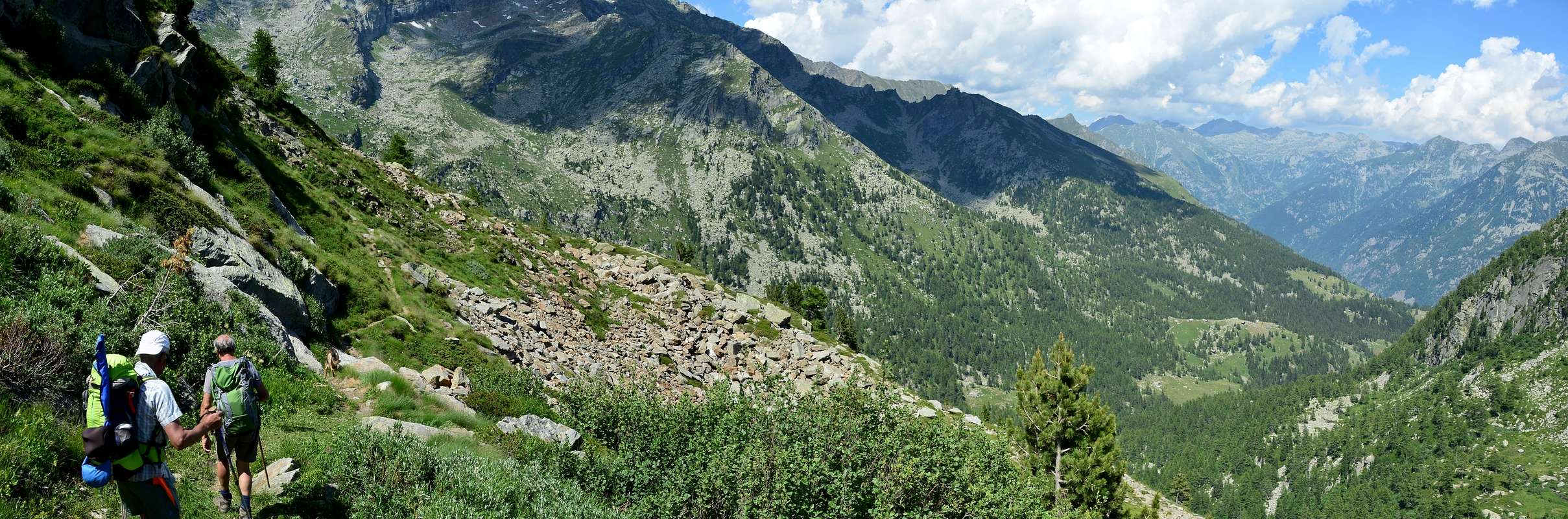
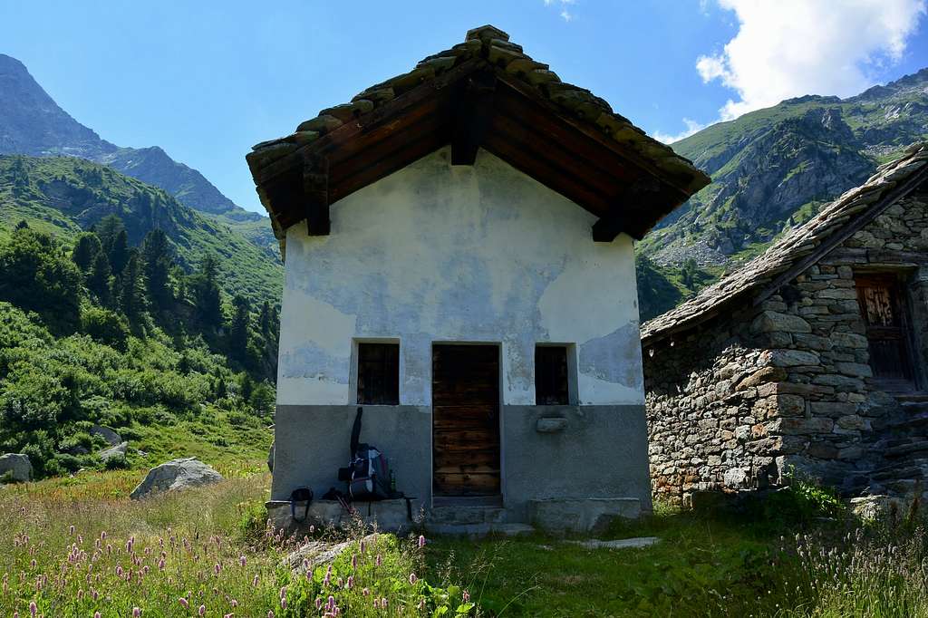
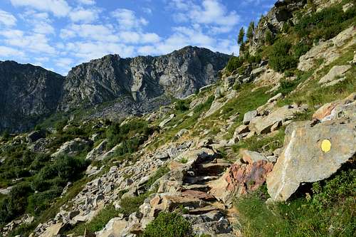
Reached Issime (953/80m; the Church of San Giacomo) with a short detour from the regional road for the Gressoney Valley, take the path n° 1/Via Alpina, that rises to the West-northwest in the direction of the Vallon of Valbona. The same, after a first series of hairpin bends reaches Santa Margherita, where comes the farm road. A long diagonal passing through the Alps Zeuin, Lamatta (1.787m), vain, Vieukie, Methia, Mongiovetta salt reaching the same in succession to reach after the Alpe di Mounes Dèsott or Lower (+; 2.008 m; Chapel of "Madonna della Neve"). Leaving the West the path continues towards that Damon and Colle Dondeuil (2.338m), it continues instead to the South via a path not numbered among a sea of rhododendrons quickly reaching the small basin where sites are four little lochs (2.263, 2.274 meters), which also ends the same (E/EE/F; 3h'00/3h'30 from Issime Municipality).
Raggiunto il Comune di Issime (953/80 m; Chiesa di San Giacomo) con una breve deviazione dalla Strada Regionale per la Valle di Gressoney, prendere il sentiero n° 1/Via Alpina, che risale verso Ovest-nordovest in direzione del Vallone di Valbona. Lo stesso, dopo una prima serie di stretti tornanti raggiunge Santa Margherita, dove arriva anche la strada poderale. Un lungo diagonale che passa per le Alpi Zeuin, Lamatta (1.787 m), Invan, Vieukie, Methia, Mongiovetta sale raggiungendo le medesime in successione per raggiungere in seguito l'Alpe di Mounes Dèsott od Inferiore (+; 2.008 m; Cappella della "Madonna della Neve"). Lasciando ad Occidente il sentiero che continua verso quella Damon ed il Colle Dondeuil (2.338 m), si continua invece verso Mezzogiorno tramite un sentiero non numerato in mezzo ad una distesa di rododendri raggiungendo in breve la piccola conca dove sono siti quattro laghetti (2.263, 2.274 metri), dove termina anche lo stesso. (E/EE/F; 3h'00/3h'30 dal Comune di Issime).
 |
 |
 |
 |
 |
Difficulties
The route can be classified as E/EE, but F.
L'itinerario è classificato da E/EE, ma F.
Essential Gear
For Hiking.
Da escursionismo.
 |
 |
 |
 |
 |
External Links
- REGIONE AUTONOMA VALLE D'AOSTA the official site.
- FONDAZIONE MONTAGNA SICURA Villa Cameron, località Villard de la Palud n° 1 Courmayeur (AO) Tel: 39 0165 897602 - Fax: 39 0165 897647.
- A.I.NE.VA. (Associazione Interregionale Neve e Valanghe).
Important Informations
- Protezione Civile Valdostana località Aeroporto n° 7/A Saint Christophe (Ao) Tel. 0165-238222.
- Bollettino Meteo (weather info) Tel. 0165-44113.
- Unità Operativa di Soccorso Sanitario Tel. 118.