
-
 4985 Hits
-
 85.87% Score
-
 21 Votes
|
|
Mountain/Rock |
|---|---|
|
|
46.49625°N / 13.88814°E |
|
|
Hiking, Skiing |
|
|
Spring, Summer, Fall, Winter |
|
|
5997 ft / 1828 m |
|
|
č, š and ž are pronounced like ch, sh, and zh.
Overview
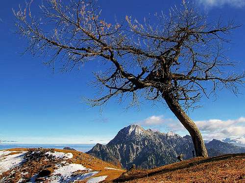
The scenery on Mojstrovica
There are summits, which are great to be looked at - bold, high postures, evoking immediately a strong desire to be climbed. They offer usually adventures and broad panoramas. And there are summits, which are nothing special - humble, low postures, usually neglected by mountaineers. Mojstrovica and Visoki vrh are such summits. Two not very high elevations in a side ridge of Karawanks, the range, which is mostly humble anyway. But they have something to offer! Solitude, dreamy nice sceneries on the upper timberline and astonishing views towards Julian Alps, first of all. Enough reasons to visit them. Until they were described in the more and more rich Slovenian mountaineering literature, these mountains were reserved only for shepherds, hunters and rare solitude lovers. Today it is perhaps different, but when we visited them, on a nice late autumn day, we still didn't meet on the mountain anyone. I personally went up there to see Kepa/Mittagskogel from its west side, but the scenery and views exceeded all my expectations. And it was a very short and easy hike, once for exception.
Geography
|
On Kresišče, 1839 m, from the main crest of Karavanke/Karawanken a side ridge deters, running first towards the south, then in a long arc turning into the SW direction and finally into the western direction. It's a complete one quarter of a full circle. This ridge lies between the valley of Belca creek on the east and Hladnik creek on the north-west. South of Kresišče there's the summit of Laskovec, 1760 m, then the summit of Tišlerica, 1755 m. South of it, there's a saddle, 1640 m, east of which Belca creek has its source. (Hladnik creek has its source west of Kresišče). This saddle reaches a narrow mountain road, coming through the Belca valley. More towards the south, a ridge ascends to the summit of Mojstrovica, 1812 m. It is grassy, with the highest larch trees very picturesque. The north-eastern slopes of Mojstrovica are actually broad alpine pastures, where in summer herds of sheep and cattle are kept. the From Mojstrovica the ridge starts turning into the SW direction. It becomes more narrow, first reaches Vrh Bašce and then the highest elevation, Visoki vrh, 1828 m. Here, some steep and today probably abandoned pastures (called |
Bašce) are also on the NW side of the ridge. From Visoki vrh on, the ridge becomes densely overgrown with pine-bush. In its lower part, where the ridge already has the western direction, there are some very rarely visited and less attractive (?) summits, such as: Vršič, 1497 m, Rez, 1412 m, and one more Vršič, 1212 m. The southern slopes of these hills are falling already down to Sava river valley. From Visoki vrh a side ridge descends also towards the south-east. In its lower part there are the summits of Jurčeva peč, 1505 m, and Jurčev vrh, 1376 m. To have the picture complete, let's mention also two elevations south of Visoki vrh, these are Vretov vrh, 1628 m, and Farjevc, 1573 m.
Panorama
Especially on Visoki vrh we are standing like on a balcony just above the valley of Sava river and in front of the whole northern flank of the majestetic Julian Alps. Great is also the view on Kepa / Mittagskogel, which we see from the W, SW side.
 Martuljek group |
 Julian Alps |
 Kepa |
Getting There

Hladnik creek valley
For general overview information see the Karawanks GROUP page. It will tell you how to reach Belca village (just west of Dovje and Mojstrana) and Gozd Martuljek village. From Podkuže, one more kilometer to the west of Belca village, a mountain road deters northwards and then over the slopes of Visoki vrh towards the north-east into Belca creek valley. This is also one of the approaches for Kepa / Mittagskogel. The valley of Belca creek is very picturesque and the road goes deep into it, until on the altitude of 1007 meters, just by the creek, the road is in summer closed for public traffic. Actually, there is no sign of further drive prohibition, only the ramp. If it is closed, then this is the end of the drive, but if it is opened... On the ramp there is one of the most humorous inscriptions (2007) - with big letters it says: "When you will be returning, the ramp will be closed". In November we drove on and it didn't happen, but as said there was no one on the mountain at all. In many turns the road ascends more than 600 meters up, until it reaches the saddle below Tišlerica. Some side roads reach alpine meadows.
The second possible approach comes through the Hladnik creek valley. On Srednji vrh, the panoramic terrace above Martuljek village, you drive towards the NE into the valley of Hladnik. The road is often bad and destroyed, but usually you can reach with a car its end on 1280 meters, where the hunters hut stands (Koča za Lepim vrhom).
Routes Overview

On the N ridge of Mojstrovica
There are too many hunters and shepherds paths to mention them all. They are all unmarked and sometimes hard to follow. Here I shall mention only a few, which reach both in the title mentioned summits.
1. Mojstrovica from the north. We start at the end of the road, on the saddle below Tišlerica, 1641 m. After the first steep part the path reaches a very nice and already panoramic summit ridge. With every next step a new nice scene appears until we finally reach the grassy summit of Mojstrovica. A real hiking feast of just 30 minutes! From Mojstrovica we continue to the summit of Visoki vrh, 20 more minutes.

Reaching Mojstrovica
2. Visoki vrh from Mikulovica. If we start a little lower on the mountain road from Belca, we can hike on Mikulovica pasture. From the end of its side road (on the pasture) we continue by a path, which crosses the slopes of Mostrovica and the upper slopes of Kurji graben (the ravine, which descends from between Mojstrovica and Visoki vrh towards the east). So we reach the SE ridge of Visoki vrh, turn there right and soon reach the highest point. One hour for the ascent. Then we can return by the ridge on Mojstrovica (as described above in #1) and down.

The scenery
3. From the tunnel on Visoki vrh. At least one path is ascending over the SE slopes and ridges all the way up from the road into Belca creek valley to the summit of Visoki vrh. We start near the tunnel, on the altitude of some 850 m. 3 hours, hard orientation.
4. From the hut in Hladnik creek valley. One path is going towards the south into the vicinity of Visoki vrh, the other path is going towards the NE, on the saddle between Laskovc and Tišlerica. So we can do the round tour, but also here the orientation might be the greatest problem. Maps: Kranjska Gora (community tourist map), 1:30000.
Red Tape
No limitations.
When to Ascend?
Mojstrovica and Visoki vrh can be ascended any time of the year. In winter and spring the mountain road is very likely not cleaned of snow. But you may come with skis. The road is not so attractive, but the upper grassy slopes of Mojstrovica can offer a nice, lonesome ski tour.
Mountain Huts
None, at least official ones. And due to the ease of ascent also not needed.