
-
 4034 Hits
-
 77.48% Score
-
 8 Votes
|
|
Mountain/Rock |
|---|---|
|
|
46.41362°N / 14.47886°E |
|
|
Hiking |
|
|
Summer, Fall |
|
|
5427 ft / 1654 m |
|
|
Overview
Name
The Slovenian name comes from the farm on Jezersko side - Virnik. West of the summit is also an alpine meadow, called Virnikova planina. The German name is Grintoutz, coming from the slovenian "grintovec", meaning meager, friable, ... In the recent times Kleiner Grintoutz is mostly used (to distinguish it from Grintovec, 2558 m, the highest summit of Kamnik and Savinja Alps), in the past it was also named Kaerntner Grintoutz and even Jaeger Grintoutz.
Character
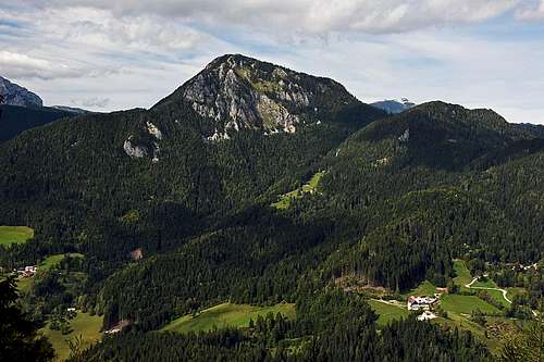

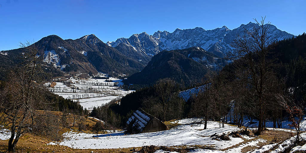
The mountain rises in the central part of Karawanks, on the border between Austria and Slovenia. There, the main crest of Karawanks is much different than west of the area and also different from the eastern part. Mountains are lower, but still rocky on their summit areas. That's because of their origin. Their summits are built of old, paleozoic reef limestones, more than 400 million years old. These mountains existed already when there were no Alps yet. And they survived till the present days. All the slopes and ridges of Virnikov Grintavec are steep and quite friable.
Due to the high lying and touristically developed Jezersko resort, Virnikov Grintavec is often ascended. It's a typical mountain for hikers. Skiing can be done only from some neighbouring saddles, and mostly by mountain roads, reaching higher and higher. For rock climbing its walls are not high enough and the rock is too friable. But some ascents require scrambling and even some easy climbing. In lower areas some crags are also appropriate for shorter rock climbs.
Panorama
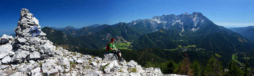
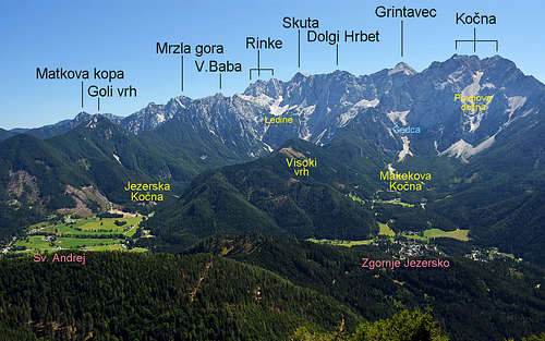
Virnikov Grintavec is one of the best lookout point for Kamnik and Savinja Alps and the panorama from its summit is great also in all other directions. Kamnik and Savinja Alps are stretching on the SE, further towards the E the rest of Karawanks is stretching (towards Olševa and Peca), on the N is the Obir massif and its mountains, futher more to the W is the whole long range of Košuta. Left of Košuta in the distance Julian Alps with Triglav can be seen. On the SW we see the sharp summit of Storžič and its neighbourhood.
|
|
Getting There

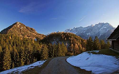
Virnikov Grintavec can be ascended from the Slovenian side and also from the Austrian side. On the Slovenian side it's Jezersko resort and its side valleys, on the Austrian side it's Trögern / Korte (valley and hamlet).
- Zgornje Jezersko, The two Sv. Ožbolt churches, 950 m, 900 m (46.395377, 14.498353). One ascent route goes also past the Roblek farm (46.405945, 14.510356).
- Jezersko, Murn farm, 1100 m. From the main road Kranj - Jezersko we drive only till Spodnje Jezersko and there turn left (NW) into the valley of upper Kokra river. Already after some 750 m we deter right again and drive by a narrow asphalted road up towards the N-NE. On the first crossroads we continue right (straight is Virnik farm) and in a long turn the road brings us to Murn farm (left below the road). Some 500 m further above the farm we can park (46.408374, 14.485254).
- Virnikova planina (meadow), 1160 m. We drive into the valley of upper Kokra river as described above, but continue by the valley till below the Robnik farm, some 940 m. There we deter right and drive by the mountain road till Virnikova planina (46.414005, 14.468168). This approach road is opened only from October 20th till June 20th, in summer we must park much lower.
- Jezerski vrh / Seeberhsattel, 1216 m. On the main road, connecting Austria and Slovenia (46.418883, 14.526722).
- Trögern / Korte, 998 m (46.438276, 14.488506). The valley and the hamlet are reachable by a good road.
Ascent Routes
1. From above Murn farm

This is the normal southern route, the shortest and easiest variant (still a medium difficult hike). On the Swiss Hiking Scale its difficulty is T3, 1 h 30 min.
From the parking place above the Murn farm, 1100 m, we continue by the road right up (plate, marks), following the marks northwards, across the forested slopes of Žarkove peči. On the left is the ravine of Murnov graben. Higher, the trail soon reaches a nice meadow. There's the border and the important meeting of trails. The plate directs you left, towards the NW, where it ascends through the woods and soon comes close to the E ridge of Virnikov Grintavec. Mostly it ascends by crossing its southern (left) slopes. The path is on some places steep and requires a bit of additional attention. In the last 15 min it goes by open, quite rocky terrain.
2. From Zgornje Jezersko
From the parish church, 900 m, we continue by the marked path northwards. It goes by the eastern side of Olipov rob (1124 m). Behind this hill the western marked variant of this route joins. Then we continue northwards, towards the slopes of Žarkove peči, where we join the route #1 and continue by it to the highest point. T3, 2 h 15 min.
If you start by the higher (old) St. Oswald church, 950 m, the continuation of ascent is not marked.
3. From below Roblek farm
We park either by the main road, 907 m, or closer to the mountain, at the Roblek farm, 930 m. From there, we continue by the road towards the Roblek farm, pass it, deter on the shortcut left to Žarkovo meadow (or go around by the road), continue left and then further up by the road to the state frontier. Great panorama from there! There you turn left and reach the #1 route, or you descend on the Roblekova planina (meadow) and continue as described in routes #4 and #5. Long, less convenient ascent, at least 2 h 30 min, T3.
4. From Jezerski vrh / Seebergsattel

We park on the state frontier, 1216 m, and continue walking by the left road towards the NW. The first hill is more steep, later the road becomes flat and very appropriate for mountain biking. It goes far westwards, finally reaching the Roblekova planina, where we cross the border, descend a bit on the Austrian side and there hit the marked trail coming up from Trögern / Korte. Following the plate we turn left and start ascending towards the state border again. We cross it on the Žingerc saddle, where we hit the route #1, which we follow to the top. 2 h, or even a bit less, using a bike. T3. Nice approach, making less altitude and more distance.
5. From Trögern / Korte
From the hamlet by the church, 998 m, we continue southwards, following the road to the Roblekova planina (meadow). This road is closed for public traffic, but nice for example for mountain biking. Some 100 m below the meadow to the right the marked trail deters (plate). We follow it southwards, until in the vicinity of the state frontier (Žingerc saddle) we hit the marked trail, coming from Jezersko. Then by it right to the top. T3, 2 h 15 min.
6. From Virnikova planina by the W ridge
This is an abandoned, today very demanding ascent, which is not marked and despite following a distinct ridge, requires good orientation skills. From the hut on Virnik meadow, 1160 m, we need some 1 h 30 min, by the Swiss Hiking Scale difficulty is T6/T5. In 2019 we needed more than 2 h, experiencing towards the top some steep and exposed climbing.


From the hut we continue by a good mountain road northwards, but very soon deter right on a steep cart-road. It does only one left turn and then disappears in the woods. The W ridge there is steep, but left of it, we can follow a shallow valley and a gentle side ridge. Where they end, we turn right and by a steep ramp gain the main ridge. Then we follow it, searching the best passages. In some places we can see remains of the old trail, and perhaps even a red dot or two, but higher on many fallen trees prevent us to follow the trail. We continue towards the very steep main ridge, then by its left (northern) slopes higher on. The forrest is steep, always try to keep right, towards the ridge. The upper part of the ridge gets overgrown by dense dwarf pines. There we crossed the ridge, following a distinct trail into the right (southern slopes). But there the trail ended and we had to climb up and to the right. Very steep, using dwarf pines and trees to hold, on some places climbing over the rocks! Around the rocky edge we descended (UIAA I or II) some 2 m into a steep ravine, which finally brought us left on the main (summit) ridge again. It's very narrow and crumbly, but passable in an easy climb.
It's possible that at the dwarf-pine barrier we should need to continue through the bush area and then trying to keep right and gain the main ridge again.
Overall, if you are able to complete it, this tour nicely combines with the #1 tour descent. We can park above the Murn farm, go by the road to Virnik meadow, ascend the summit by the W ridge, and descend by the normal route to the car. 4-5 hours altogether.
When to Climb

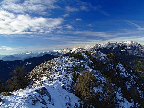
Virnikov Grintavec can best be ascended in dry seasons. In these regions it's between June and October (or the first snow). Ascents in winter conditions can be dangerous (steep path in the upper part) and require appropriate winter equipment (ice pick, crampons).
Camping
Jezersko resort is touristically well developed, so you can stay overnight there.