
-
 3408 Hits
-
 83.69% Score
-
 17 Votes
|
|
Mountain/Rock |
|---|---|
|
|
46.39388°N / 14.42117°E |
|
|
Hiking, Scrambling, Via Ferrata |
|
|
Spring, Summer, Fall, Winter |
|
|
5551 ft / 1692 m |
|
|
Overview
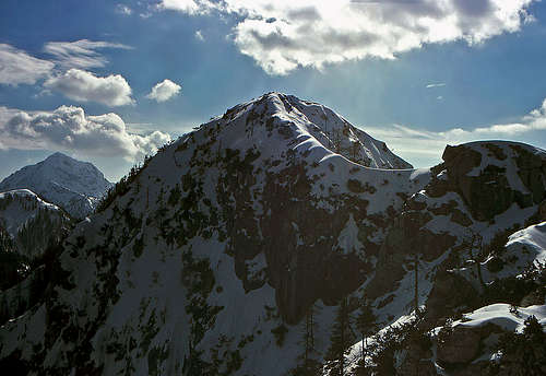
Stegovnik NE ridge in winter

Late afternoon on Stegovnik

Stegovnik waterfall
Stegovnik is the most dominant summit in the ridge which runs from Pečovnik, in the main ridge of Karavanke, towards the south, until it ends on Javornik saddle, just before the face of big Storžič, which belongs already to Kamnik & Savinja Alps. The summit is rocky, despite its relatively low altitude. We'll see in the chapter of geology why. That's why the summit ascent requires also some additional carefulness. Especially on a winter ascent we must carefully consider conditions up there.
Otherwise Stegovnik is quite frequented, from both sides, from Tržič and from Jezersko. Mountain roads are reaching high, but it is interesting that they don't cross the main ridge to connect both valleys. Still, a mountain bike across the main ridge is possible, it requires some struggling only in its higher sections.
So, the summit is first of all a nice hiking goal. On a tour we can visit a few nice natural attractions, find solitude in the surrounding woods and enjoy very nice panorama from the top. Both secured main paths on the summit of Stegovnik are well maintained.
Very close to Stegovnik, just towards the NE, in the main ridge the summit of Ruš is rising. That one will perhaps not be the main goal of your trip, but it is also a pleasant summit, with almost equally broad view around, as the one from Stegovnik. Also Ruš is quite steep and rocky, the only recommended ascent on it goes by the SW ridge.
In the area of Stegovnik two natural attractions are worth of a visit. From below the western side of the mountain the Stegovnik creek flows down towards Medvodje. Before reaching the main valley it jumps over a rocky wall and forms a nice, small waterfall. From Medvodje (reachable by car) to the waterfall you have only a short hike. Of course it is best to come at high waters, in summer, the creek is quite dry. The second attraction is a natural window in the SW ridge of Stegovnik. Through it one of both marked paths on top goes anyway. A few other attractions (caves) are more hidden, hardly reachable, and known only to a few local experts.
Summit views

Kamnik & Savinja Alps

Western views
Stegovnik rises exactly in the middle, among the high summits of Košuta, Storžič and Kočna and Grintovec group. As we are looking on Storžič from the north, it usually appears only as a sharp peak, on which we only hardly distinguish any details. On the contrary we see in the long ridge of Košuta every detail, until on the left its last summits get lost in haze, or seem like continuing to the groups of Stol and Triglav. The most beautiful are however the summits of Kamnik and Savinja Alps, especially when we find ourselves on the summit of Stegovnik towards the evening, when the highest mountains are already lit by the descending sun.
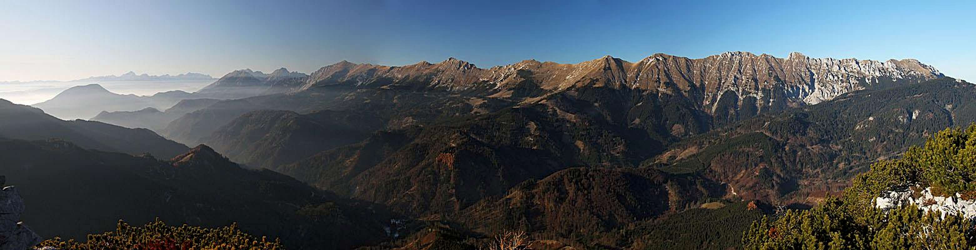 Košuta range
Geology
The Southern Alps are mostly build of Triassic limestones and Dolomites. But just south of the Periadriatic Fault there are a few ranges, which are some 100 million years older, originating from carbonate sediments, which were depositing in the Paleozoic ages of Devonian, Carboniferous and Permian. In addition to the main Carnic ridge such mountains are found also in western Karawanks and in the group west of Jezersko. On these Devonian limestones are not found only in the valleys (at faults) but they are forming also the summits and ridges, being thrusted over younger Carboniferous flysch layers. And Stegovnik is a typical such mountain. Its summit rocks are sedimentary, but almost 400 million years old, from the middle Devonian, the relics of a huge mountain range which raised during the Variscian orogeny. That is why hiking on Stegovnik is interesting also from a geological point of view. Also in lower parts we can observe colourful rocks which can otherwise not be found in younger, Triassic massifs.
By its geological diversity and abundance of fossils, also Dovžanova soteska (canyon) is worldwide known. It is situated west of Stegovnik, where the Tržiška Bistrica creek made its way through many layers of rocks of differen ages.
Dovzanova soteska (gorge)
Dovžanova soteska is a gorge on Tržiška Bistrica creek, north of Tržič town. It is famous by abundance of fossils, which were found already end of the 19th century in its diverse Paleozoic rocks (Carboniferous and Permian). In 1988 the gorge was proclaimed as natural monument.
On the left bank of the gorge there are several rock towers, built of more solid limestone. They are called »The Kušpegar's belfries« (by the nearby Kušpegar farm) and are a popular rock climbing area. In 4 sectors there are almost 50 routes of difficulties from 6a to 8a. Here's the link to the climbing site of Dovžanova soteska (in Slovenian).
Getting there
We can ascend on Stegovnik from virtually all sides. Let's leave aside more distant trailheads, as when we get on top over Veliki and Mali Javornik, or by the whole northern ridge. Let's focus only on those trailheads, which are closest and most convenient for a quick ascent on top.

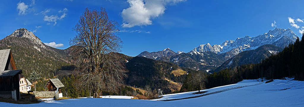
Dol in late autumn

Alpine meadow 1150 m
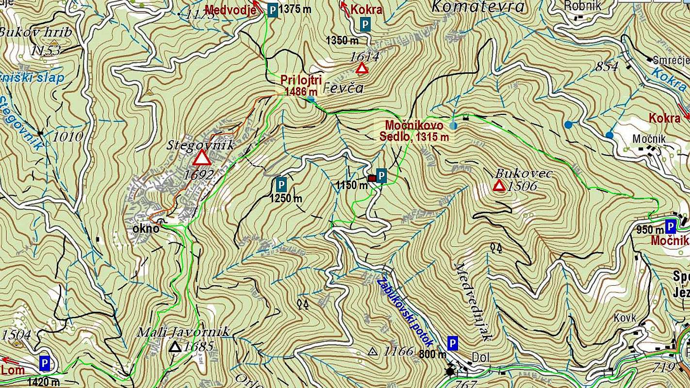
On the south a good trailhead is in the valley of Reka creek, into which we deter from the main road on Jezersko at the Kanonir inn. In the Reka valley, there's a place, called Dol, where we must turn right, into the side valley of Zabukovski potok (creek). But there the road is in summer closed already on some 800 m. But outside the period from June 20th to September 20th we can drive up that valley. On the altitude of 1000 m the mountain road branches and we drive right and up to the alpine meadov on 1150 m, where a cute hut stands. There from the road the marked path on Močnik saddle branches. But we can drive by the road (it has higher a dead end) even further on. When reaching some 1250 m of altitude, towards the SE wall of Stegovnih a cart-road branches and there is the last trailhead on this side.
The second marked path starts just in the valley of Kokra river, on the main Jezersko road, soon above the Kanonir inn. Above the Kokra valley it reaches the big Močnik farm, on some 950 m (see the picture below!). Till there we can also drive by a car (from Spodnje Jezersko).
The third trailhead on Jezersko side is the upper valley of Kokra, or in Komatevra. From the main Jezersko road we deter there in Spodnje Jezersko, drive past the travertine quarry and further on, till high below the main ridge. From that mountain road we can deter left already on some 1200 m, or on the last branching on some 1350 m. From those two dead road ends no marked path goes towards Stegovnik, but we are already very high.
From Tržič side, the first very good trailhead lies on the last crossing below Javornik meadow. We drive there by a mountain road from Grahovše, in the Lom valley. At the last farm the ramp lifts up for 1 EUR, but dont forget to have another 1 EUR for the return!
And finally, high up reaches also the road from Medvodje, also from the Tržič side. We reach north below Stegovnik, on some 1300 m, from where we can ascend on top in one good hour.
Summit ascents
1. From the SE

The lower NE ridge

Along the NE summit ridge
The path by the valley of Zabukovski potok (creek), or from the meadow on 1150 m above it, and the path from Močnik farm and further on across the northern slopes of Bukovec, join on Močnik saddle, 1315 m, just west of the Močnik alpine meadow. From there the marked path crosses the southern slopes of Ruš (from the cart-road you need to deter right up the slopes) and in the NW direction soon reaches the saddle Pri lojtri (At Ladder), 1486 m. There many marked paths are crossing. The path on Stegovnik continues towards the west, at first comfortably by by the main, NE ridge, which however soon becomes steep and in wet or snowy conditions dangerous. On short level sections nice views on the main summit open, then again steeper rocky sections follow. Before reaching the last shoulder, the path turns on the northern side and by a narrow, with a steel cable protected ledge we cross the rocks. Then the path goes through dwarf pines and over easy rocks on the main summit.
From Dol we must do some 950 m of altitude, 3 h. From the Močnik farm we have some 750 m to do (2 h 15 min). By the Swiss Hiking Scale the last sections of the hike up would be graded T3. Gear: only good shoes and poles.
2. By a non-marked SE variant
If we drive by the valley of Zabukovski potok (creek) to the highest point of the mountain road (some 1250 m), we find ourselves already high below the SE wall of Stegovnik. There we deter from the road on a rugged cart-road, and from it soon on a non-marked path towards the left. We soon reach the marked path which goes below the walls, connecting the two main saddles of Stegovnik. Just there the marked path has its lowest point. From there, we can go by the marked path either right on the saddle Pri lojtri, and then on top, or left on the saddle between Stegovnik and Mali Javornik, and from it on top by the route #3. A section of the path towards Pri lojtri saddle is a bit narrow and crosses steep, forrested slopes. Altogether we have to the summit 1 h 30 min, difficulty is T3.
3. From the SW
We start the hike on the last crossroads of the road, which comes from Grahovše towards the Javornik alpine meadow. We are on 1420 m. The marked path goes towards Stegovnik all the time across the western slopes of Mali Javornik. The second option is only a bit longer (offering the alternative and the round tour). We can go by a shepherds path and cart-road further towards the east and even southeast on the main ridge where we turn left and by a marked path cross the eastern slopes of Mali Javornik. On the saddle just below Stegovnik both variants join. Till there we can also reach from the mountain road, coming up from Dol (see the route #2).
In continuation the marked path enters the rocky slopes of Stegovnik. We soon reach the rock window and go through it. There the path is protected with cables and a ladder. When this attraction is behind us, the path turns right, ascends steeply up and in turns reaches the main ridge. There we turn left again. Till the main summit the hike by the ridge takes still some time.
From Dom pod Storžičem we'd need some 4 h to the summit, from the crossroads below Javornik meadow some 2 h, from Dol some 2 h 30 min. By the Swiss Hiking Scale the last sections of the hike up would be graded T3. Gear: only good shoes and poles.
Quite high till below the saddle between Mali Javornik and Stegovnik also mountain roads from Tržič side are reaching, but the path further on are not marked.
4. From the north
All these approaches go over the saddle Pri lojtri. The trailhead is on the road, coming from Medvodje high below the main ridge. On the altitude just above 1300 m we can catch the marked path, which connects Brsnina alpine meadow and Pri lojtri saddle. The ascent is short and easy, the path further on top is described under #1. 1 h 15 min, T3.
5. From the NE
Driving up by the valley of Komatevra, we can park on some 1350 m. From there towards Stegovnik there is no marked path, but we can go towards it by any ravine or forrested ridge, reach the main ridge and close to Fevča alpine meadow reach the marked path, described in #4. In a few minutes we are from there on Pri lojtri saddle.
Ruš, 1614 m

Storžič from below Ruš

The 'Skater' on Ruš
When we find ourselves on the ex alpine pasture of Fevča (the above described paths #1, #3 and #4 bring us there), we have on the summit of Ruš only a short jump up. A good, but not marked path leads us towards the east, then we soon reach the SW ridge. From it we have already nice views on Storžič and Kočna, but it's worth continuing just on the highest point. That one is decorated by a nice root, replacing the usual cross. If you look well, you will see in it a form of a skater.
Bukovec, 1506 m

Bukovec summit
This is a nearby summit in the ridge, which goes from the Močnik saddle towards the SE and is delimiting the valleys of Kokra and of Zabukovski potok. By the ridge goes a weak, non-marked path. The closer we are getting to the highest point, the lighter the forrest gets. Finally we see ahead of us the nice summit meadow, but stepping on its grassy highest point we are bitterly disappointed. The meadow is surrounded by a dense wall of trees, so this summit is offering almost no views around.
The southern side is also forested, but is criss-crossed by forest roads, which however don't reach the highest point.
East of the summit there's the big, nice Močnik farm, protected as a national cultural heritage. There rises also a huge linden tree, more than 300 years old, almost 40 m tall and with 730 cm of circumference - still all healthy and vital.
Mountain huts
We don't need huts to reach the summit of Stegovnik. The only official hut is only the more remote Dom pod Storžičem, in summer also the private hut on Javornik alpine meadow is opened.
When to ascend Stegovnik?
We best ascend Stegovnik in dry seasons. As mountain roads are reaching high, also a winter ascent is doable, despite short days. The summit part of course requires winter equipment (ice pick and crampons). On mountain roads a mountain bike can be helpful, and when covered by snow touring skis.
External links
- I Feel Slovenia - The Official Travel Guide by Slovenian Tourist Board: Dovžanova soteska (gorge)
- Plezanje.net - The Slovenian rock climbing site: Dovzanova soteska