
-
 5737 Hits
-
 87.31% Score
-
 24 Votes
|
|
Mountain/Rock |
|---|---|
|
|
46.52920°N / 14.34424°E |
|
|
Hiking, Skiing |
|
|
Spring, Summer, Fall, Winter |
|
|
6309 ft / 1923 m |
|
|
Overview
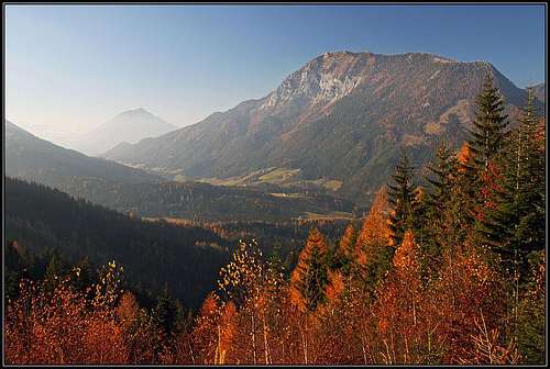
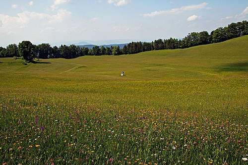
Freiberg/Setiče above Zell/Sele
What's New On This Page?
> June 24th, 2013: Info about Macna/Matzen added.
> November 24th, 2011: First set up of the page.
General Information
Freiberg / Setiče (also Austrians write the Slovenian name Setitsche) is a broad mountain massif west of Hochobir, in the northern chain of Karavanke / Karawanken. Even if it does not exceed 2000 meters, many summits in the area have also steep and rocky slopes. The views from the highest points are very nice, especially towards the south on Košuta range and further in the distance along the valley of Drau/Drava river. I only once ascended the highest summit and the summit of Macna/Matzen. If you have valuable information about Javornik and Črni vrh, please add it.
On this page in the future information about the following summits should be presented:
> Freiberg / Setiče,
> Jauernik/Javornik,
> Schwarzer Gupf / Črni vrh,
> Matzen / Macna.
A Bit of Geography
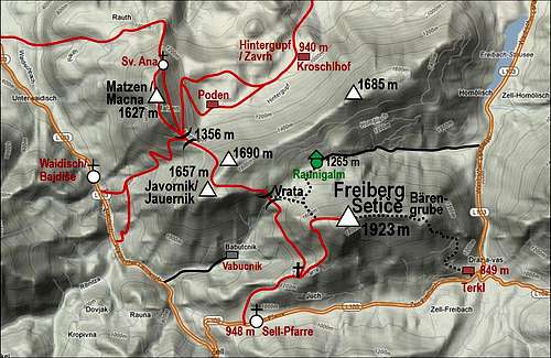
The higher mountains in the area form three smaller groups. Freiberg / Setiče is stretching from Wrata/Vrata saddle on the west to Freibach valley on the east. North of it a long ridge goes from the double summit of Jauernik/Javornik, 1690 m, on the W-SW to Schwarzer Gupf / Črni vrh, 1685 m, on the E-NE. And finally NW of Jauernik/Javornik there is the summit of Matzen/Macna, 1627 m. Between these three parts of the massif there are two saddles, which can be crossed by quite good paths: Wrata/Vrata, 1376 m, and Hansenruhe/Koce, 1356 m.
Freiberg / Setice Description
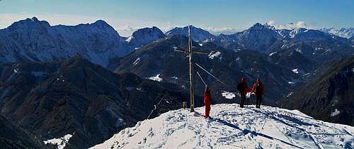
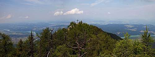
On the summit of Freiberg/Setiče

Freiberg/Setiče from the E
Matzen/Macna Description

Western views

Sta. Ana
The northern summit of Matzen/Macna, above the valley of Drau/Drava river
Getting There

Zell-Pfarre / Sele pri cerkvi
Freiberg/Setice
You can start hiking into the massif og Freiberg / Setiče from almost all sides. For the highest summit, the most important trailheads are:
1. Zell-Pfarre / Sele - Pri cerkvi. Here the shortest and most used (and beautiful) approach starts.
2. Waidisch/Bajdiše or the point on the road 2.5 km SE of the village, where the mountain road goes up to the ex Vabucnik farm.
3. Terkl/Trkelj inn in Zell/Sele.
4. Homoelisch/Hmeliše, near the southern shore of the lake.
All these points are either on the road Ferlach - Eisenkappel, into the valley of Freibach, you can drive also from the north, from the valley of Drau/Drava river (Wildenstein).
Matzen/Macna
The summit, the chapel and the cave can be easiest reached from Hintergupf/Zavrh hamlet, where in the famous Kroschlhof/Krošel inn we can also sleep. Hintergupf/Zavrh is a charming place itself. Especially in June, on the northern part of the terrace you can find one of the most beautiful meadows in Karavanke/Karawanken.
Meadows near Zavrh/Hintergupf hamlet
Routes Overview
The path from Zell/Sele gains the main ridge by this small hut

SW views

Summit plateau

On the summit ridge
Freiberg/Setiče from Waidisch/Bajdiše. From this village the marked path goes up towards the NE on Hansenruhe/Koce saddle. But that is a longer option, because in the continuation we must cross the summit slope of Jauernik, descend to Wrata and from there continue on top. A shorter route starts some 2.5 km SE of the village, 661 m, by the bus station where a mountain road starts up towards the ex Vabucnik farm, 940 m. From there, you can continue towards the E-SE and reach Užnikkreuz (then on top as described above), or continue on Wrata and from there right on top. Altogether 4 h.
Freiberg/Setiče from Terkl. By this inn an unmarked approach goes on the east ridge of the mountain. We go first some 5 minutes by the road towards the west, then by a mountain road up towards the north. Above, the path is poor and brings us on Baerengrube / Medvedja raven, where we turn left and continue by the panoramic east ridge on top. 3 hours, less recommendable.
Freiberg/Setiče through Suchagraben. We enter this valley by the southern shore of Freibach lake. The mountain road is closed for public traffic and ultimately brings us to Raunigalm (alpine meadow). From there by not steep slopes towards the south (meadows) on the main ridge and left by it on top. This is also a possible ski tour. 4 h to 4 h 30 min.
Other approaches on Freiberg / Setiče are longer. But also other summits of the group can be rewarding goals of a hike. Jauernik is also very panoramic and can be reached either from the west, east or north (and also from the south through Vabucnik valley). Very interesting is also the protected path from Užnikkreuz across the western slopes of Freiberg.
Matzen/Macna from Kroschlhof/Krošelj. On the crossroads, where the road goes right to the famous inn, you continue left, towards mountains. You can also drive here a few hundred meters, then the sign stops you. The mountain road soon turns westwards. You pass a nice, interesting meadow and contionue till the crossroads, where marks turn you left. The other option would be to continue by a good forrest road towards the SW. In both cases mountain roads reach the eastern slopes of Matzen/Macna, then you continue by the upper road across them to Hansenruhe/Koce saddle, 1356 m. There only the true ascent begins.
The southern route sticks to the main ridge. It soon becomes steep and requires some care. But you gain altitude quickly and from the ridge you already have very nice views on both sides. Soon afterwards you reach the southern summit. 2 hours from the inn, difficulty would be T3 by the Swiss Hiking Scale.
It is very recommendable to continue from the south summit to the northern one. The path is still steep, but not harder than so far. This part of the ridge is called "Turni" (towers) and indeed you cross a few rocky elevations. On the northern summit there is a big cross. There the tiny trail turns right, into the eastern slopes. It gets very steep and protected by steel cables. In the next notch you continue by the eastern slopes (cables go up on the next panoramic bump) and soon the ridge gets less steep. After losing some more 50-60 meters you already reach the cute Sta. Ana church.
 On the south ridge |  South summit |  North summit - "Turni" |
It is interesting that from the church no marked path goes directly down to Kroschlhof/Krošelj inn. The marked path which continues by the ridge turns left and descends as far as on Rute hamlet. To return on the starting point, we must turn at the church sharp right. A good, marked path now crosses the whole eastern slope of Matzen/Mace, exiting finally on the southern ridge, a few minutes above Hansenruhe/Koce saddle. From there you return by roads.
Huts & Camping

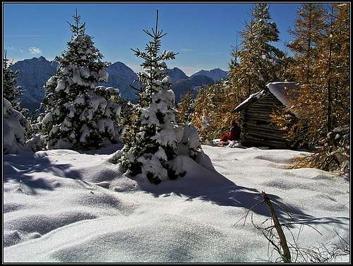
Kroschlhof/Krošelj

Welcome!
Red Tape
No limitations.When to Ascend?
Freiberg / Setiče can be ascended any time of a season. For the route from Zell-Pfarre dry season is recommended. The path is steep enough that in snow it can become dangerous. The northern approach is also suitable for skiing.Matzen/Macna can be best ascended in snowless months - usually from start of June till end of October.
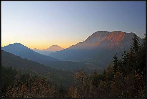
Zell/Sele and Freiberg/Setiče at dusk