
-
 2157 Hits
-
 77.48% Score
-
 8 Votes
|
|
Mountain/Rock |
|---|---|
|
|
46.45157°N / 14.22220°E |
|
|
Hiking, Scrambling |
|
|
5869 ft / 1789 m |
|
|
- JUL 25th, 2021: The NW crest route added (thanks to Martin Fürnkranz)
Overview
It's a side summit and not a very high one, even for the Karawanks range. But being indented to the north of the main chain, it has a wonderful panorama and the scenery of nearby high walls is fantastic. It is quite easily reachable, but the upper part of the mountain is rocky and very steep, so even the normal ascent requires a careful step. And, for me personally, Rjautza/Rjavica also had a few challenges, knowing that weak, unmarked hunters paths are reaching high on it. According to the book „Alpenvereinsführer Karawanken“ by Hans M. Tuschar (1990) there is also the name „Braune Wand“ for Rjautza.
Geography
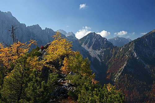 On the ridge
Let me briefly describe here the geography of the whole side ridge of the Karawanks, the ridge, in which Rjautza is the highest point. It starts north of the sharp cone peak of Palec / Selenitza, rising in the main ridge of Karawanks. Below its north wall, there is the saddle of Strach Sattel / Dolič, 1640 m, where the S-SW ridge of Rjautza starts. It is sharp and overgrown, yet through dwarf pines and over rocks a tiny path goes. The ridge ends on Rjautza and continues from its summit towards the NE. It is quite rugged and precipitious towards the N, going to the next ridge elevation - Weisse Wand / Bela peč, 1665 m. Next elevation towards the NE is Heilige Wand / Sveta peč, 1613 m. In the vicinity of this summit, there are some nice alpine meadows, but I guess locals are not keeping herds there any more. Even further to the north, the ridge gets completely forested and is not much interesting for hiking. Over many elevations it lowers down to the valley near the Windisch Bleiberg / Slovenji Plajberk.
If we return back on the highest part of our ridge, there it's important that the northern and western side of it is very steep and rocky in the highest part. Below those walls and ravines there are some 200 m long scree fields, but below them the forests are still steep and above the Bodental valley there are still some rock crags. The SE side of Rjautza's ridge is also very steep in the upper part, but generally, the rock walls are much lower and below them the slopes are even hosting some mountain roads.
Geologically, the whole upper part of Rjautza is built of brittle Schlern Dolomite (Middle Triassic). The border to the more compact Dachstein Limestone is on Strach Sattel / Dolič, where obviously a geological fault runs. On the northern side of Rjautza and on lower parts also older limestones and dolomites can be seen, and between them, flat meadows were created on volcanic tuff (like on Ogris meadow, on the other side of Bodental).
What To Do There?
Rjautza is very nice for a half-day hiking tour, on which people overcome some 800 m of altitude, usually ascending and descending by the same (normal) route. If the upper slopes are covered with snow, the ascent can be dangerous, and in hard winter (ice or deeper snow) the ascent should be avoided. In lower parts, up to the meadows below Heilige Wand) one can ride up by a mountain bike or in winter walk up by the road with snow shoes. For skilled hikers, the round tour with the descent by the SW ridge can be recommended. It requires some scrambling in a very steep and crumbly terrain. The eastern side of Rjautza is also appropriate for tour skiing, but the very summit part is very steep.
Summit Views
 Eastern views
 Drau/Drava valley
 Palec and Vrtača
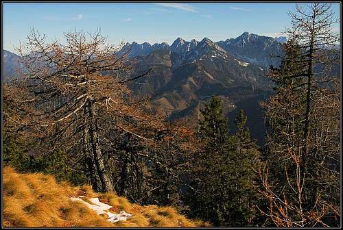
From Rjautza, great are the views on the nearby high mountains of Karawanks. They are showing high, impressive north walls. Wonderful are also the views along the Karawanks range, towards the west and east. And towards the north, across Kärnten, the views are completely open.
Getting There
 Bodental/Poden
For the summit ascent, two trailheads are possible:
- The northern portal of Loibl tunnel. You park just near the Austrian customs office.
- The Bodental (valley), the most beautiful valley of Karawanks. The normal ascent starts at the Sereinig Gasthof (hotel), 1000 m. From there, you can drive further into the valley till the big farm of Bodenbauer / Podnar, 1056 m, and park there.
Ascent Routes
|
There are more routes, but in 99% people are reaching the summit of Rjautza by the normal ascent route (red lines and dots on the map left - CLICK on them!). Brown lines and dots are the demanding SW and NW ridge routes. 1. Normal Route Approaching from the N Approaching from the NIt comes from the north, from Sereinig and is marked with No. 12. The marks are yellow circles with black number. Below, the route goes by the road, the middle part is an easy, marked path of T2 difficulty and the upper part is a medium difficult hike up of T3 (on the Swiss Hiking Scale). Even if it's only 800 m of ascent, the distance is considerable and in the upper part the path goes a bit up and down as well. So, count with some 2 h 30 min for the ascent. In winter conditions, this can be also a ski tour, difficult in the upper part! Description. From the Sereinig hotel, continue over the meadow towards the SW, following the marks into the valley (Bodental, Märchenwiese, etc.). In a few minutes you hit the main road again, but there you go left immediately - on the mountain road (there you can also park). The sign prohibits public transport, indicating it's a forest road (Forststraße). |
Then you follow the road till some 1230 m (30 minutes). The next turn of the road you cut by a trail, which goes in the same direction. At a forest hut you hit the road again and follow it till the next curve (left turn). There, you leave it again, continuing in the same direction (southwards). A moderately steep path ascends through the forest, then goes a bit right and reaches a narrow ridge (Požgani rob), where the view into the valley-end opens. On the ridge the path turns left, continuing through the woods towards the SE. On some 1580 m, you gain the main ridge of Rjautza - nice meadows there. 1 h 45 min till there. By the main ridge you go mostly in the southern direction. But the terrain becomes more difficult. The slopes are steep and the trail must seek the best passages, going a bit left and right, but also a bit up and down. Ahead of us we already see occasionally the high, rocky and still overgrown main summit, but we approach it only slowly. When below it, the path crosses a scree slope, then goes steeply directly up, gains the eastern summit ridge and in a few minutes by it the main summit. You best descend by the same route. Be careful in the steep, upper part! A dilemma. It would be nice if one would not need to start the tour at the Sereinig, but closer to the Bodenbauer. Perhaps from the main road some 400 m below the Bodenbauer, one could find a path up by a side valley, hitting the ascent road below the hunters hut? That would shorten the ascent and in case of a round tour also shorten the return by the main road.
2. Normal Route From the Ljubelj Side
From the Austrian customs office we continue by the road towards the Pamž / Pamsch farm. Below it, we continue by the mountain road, which crosses the slopes of Palec and later of Rjautza. It crosses many ravines and ridges. On the ridge, some 1200 m high, towards the left an unmarked hunters trail goes left. It would bring us to the hunters hut on 1360 m, but we can also continue by the road, which goes far around. It's some 30 min longer, but safer. From the hut we continue in the SE direction, until reaching another (new) hut, ca.1470 m. There we at first keep right (so encircling the Heilige Wand) and then left to join the marked path No. 12. By it we continue on top, as described in the route No. 1. 3 h 15 min.
As said, the slopes on the Loibl/Ljubelj side are appropriate also for tour skiing. Gaining the summit ridge and the cross is very steep and could require use of crampons. Skiing there is very demanding! In winter conditions you must start the tour in the valley. One starting point is by the church of St. Leonhard, ca. 780 m, or the farm of Mečiž (Metschisch) above it, ca. 920 m. The second starting point would be the bridge over the creek in Selenitzagraben, 930 m. Then you follow the forest roads and cart roads towards the west, the routes join east below the summit of Heilige Wand. Then you proceed towards the meadow with the second hut east of Weiße Wand, thentowards the main ridge and (probably on foot) on the summit. In German, excellent description by Martin Fürnkranz is here.
3. Descent By the SW Crest And To Bodental Valley-end
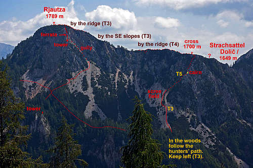 The western side with the descent route. Thanks for drafting this information to: Martin Fürnkranz!
This is a difficult hike, in the upper part a scramble and even some short stretches of easy climbing. The whole route would be graded on the Swiss Hiking Scale with T5. Also orientation is difficult. On many stretches we can follow a very weak trail, other stretches are pathless. The route is basically not marked, but on some key points you'll find valuable marks: red arrows or cairns. Try to follow them as much as possible! This route could of course be used also for the ascent, but there are two good reasons not to go up there: (1) below the summit walls there are quite long and soft scree fields - nice for sliding down, hard for hiking up. (2) Above the Bodental valley-end it's almost impossible to find the start of hunters trail in the woods.
Descent description. From the summit of Rjautza we simply continue towards the SW by the main crest, following a nice trail. But the crest soon gets narrow and rocky, so the more and more weak trail descends by the left, S slopes. It's steep, on two key points you'll find a red arrow. After losing some altitude, don't continue down any more. Inspect every weak trail which crosses towards the right. On the key point where you stop descending and start crossing towards the main crest, there's another arrow in the woods. After short crossing you should find yourself on the narrow main crest again. You climb down by it without much difficulties, finally reaching a distinct shoulder, where you see a metal cross. Continue to it.
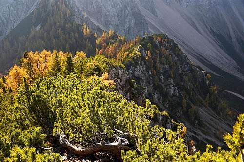 The S-SW ridge
 At the ridge cross
 Scree fields
At the cross, you must leave the main crest down towards the right - over the steep, rocky NW side. At first, passages are fine and in the steep terrain you can use branches of dwarf-pines. A soft and steep ravine is protected by a short cable. So, you carefully descend, choosing the best passages or using a tiny trail. Then you reach a distinct ravine which is steep and should not be used. On a small notch on the left you should spot a clear sign. Cross-over till there and continue down on the other side. Rocky terrain should bring you on an edge with a bigger cairn. Again don't go right down by the ravine, but by the rocky crest again, only behind the edge turning right. Now you are almost down on the screes. Only the last best passages to be found and down you are. Then slide down by the first scree field, switch on the left one and follow it till the end. Where it reaches the woods, a good path is cut and you should follow it. In the woods, keep left, trying to follow the hunters path. The terrain is still steep, below some crags the paths does a turn or two, bringing you to a water source. There, cross the ravine and follow the path which crosses to another scree field. There the path starts ascending a bit. I guess it would be best to follow it. You'd reach the open terrain below the walls of Palec and only there turn right down. We unfortunately wend down by the scree field again, finding ourself in very dense dwarf-pines. So, we had a difficult bushwhacking stretch of some 20 minutes, before reaching another scree slope and in its bottom a lighter forest. Then by a pathless terrain directly down into the main valley and from the beautiful Märchenwiese (Fairy Tale Meadow) by the road another weak 1 hour to Sereinig.
4. From the NW
In ascent (from Märchenwiese) you first need to reach the place where the descent tour #3 reaches bottom of the scree fields. From there you don't go up the scree fields, but continue by the hunters trail towards the NE. So you reach the area south of the Turm (cross on it), where you deter right off the hunters trail (it continues across the slopes, finally reaching the saddle between Weiße Wand and Rjautza), still following a weak trail. You continue southwards (right of the NW crest) and then turn left to the entry into a steep, pathless gully. The gully is unpleasant, requiring also climbing of UIAA I-II degree. It brings you on the NW crest of Rjautza, on a small notch near the another tower with cross. That crest is secured by a very thin cable and is also very exposed. It finishes close to the summit. On the above annotated picture only the very upper part of this route is drawn (and the two crosses).
(Description sent by: Martin Fürnkrantz on July 25th, 2021)
5. From the Strach Sattel / Dolic (?)
This important saddle between the summits of Palec / Selenitza and Rjautza can be easily reached from the east. On that side, below the saddle, there is also an abandoned mountain pasture (Strach Alm). From the Ljubelj tunnel (Austrian office) you start by the road towards the Pamž / Pamsch farm, follow it around the first ridge and in the next broad valley jeave the road, going left up. Till the saddle once a weak path went, today it's quite abandoned. The western side of the saddle is very steep and rocky. There no good passage comes and you also shouldn't be looking to descend there.
From the Strach Sattel / Dolič, 1640 m, towards the summit of Rjautza the already described SW crest goes. The above Route #3 left it by the cross some good 60 m higher. It's almost certain that the path from the saddle goes also up by the crest till that cross. So, it's a nice ascent option of some T4 difficulty (by the Swiss Hiking Scale). It's also possible that the trail avoids the first rocks above the saddle by the right side. But there are some short rock crags as well.
Other
Across the western side of Rjautza, so below the upper walls, there are many hunters paths. One of them is crossing the scree slopes below the upper walls, joining the marked trail on the saddle between Rjautza and Weiße Wand. Hunters paths are also connecting to the Požgani rob side ridge and there are also some paths on lower sections of the western side.
When to ascend?
Rjautza can best be ascended in dry seasons. Usually that's from June till October or the first snow.
Red Tape
There are no formal restrictions on this mountain. The forest road from Sereinig is not opon for public traffic.