
-
 2719 Hits
-
 76.66% Score
-
 7 Votes
|
|
Mountain/Rock |
|---|---|
|
|
46.49693°N / 13.97069°E |
|
|
Hiking, Scrambling |
|
|
Summer, Fall |
|
|
6473 ft / 1973 m |
|
|
Overview
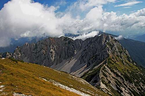
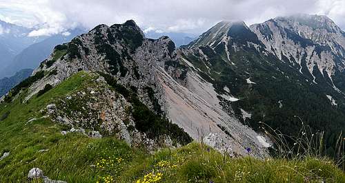
Lepa Plevelnica and Visoki Kurjek from the W, from the summit of Gubno
The eastern part of Kepa / Mittagskogel massif is mostly pathless and rarely visited. The overall name for the whole ridge east of the broad Kranjsko sedlo / Krainer Törl, 1875 m, is Plevelniki and its highest elevation is the rugged peak of Visoki Kurjek / Bärenkogel, rising just S-SE of the saddle. More towards the east the whole massif of Kepa / Mittagskogel is ending on the distinct Mlinca saddle, 1581 m, from which the normal route on the summit of Visoki Kurjek goes. While the main ridge of Karavanke / Karawanken mountains continues over the Mlinca saddle, a side ridge goes in a long arc towards the NE, where it lowers and disappears in rugged rocky and forrested ravines. And finally, the summit of Visoki Kurjek is not rising in the ridge of Kurjeki (but, as said, in the ridge of Plevelniki), which is much lower, attaching to the main Kepa / Mittagskogel ridge from the SW at the summit of Gubno / Hühnerkogel and hosting an interesting hunters path.
The summit ridge of Visoki Kurjek consists of many rugged ridge elevations, which must be crossed on the normal ascent route. Towards the N-NE of it, there is a ridge elevation where the ridges are branching. It is called Lepa Plevelnica, 1959 m. The summit is grassy and partly rocky on the SE side (towards the Mlinca saddle) and has short, crumbly rock walls on the NW side, continuing towards the N walls of Visoki Kurjek. Lepa Plevelnica is a very nice goal for hikers and is more easily reached as Visoki Kurjek. SW of Lepa Plevelnica there is a high saddle, beyond which the main ridge continues towards the Visoki Kurjek with a few rocky towers. Then the foresummit comes and finally the highest two elevations of our mountain. The continuing ridge towards the NW, down on the Kranjsko sedlo / Krainer Törl, is very sharp and crumbly and is not something which would be recommended to even more experienced climbers. Don't try to continue crossing the whole ridge by it!
Geology
As the neighbouring Kepa / Mittagskogel, also the summit part of Visoki Kurjek / Baerenkogel is made of late Triassic (Norian, Rhaetian) dachstein limestone with some dolomite. That explains its rugged, brittle nature. Lower parts of those mountains are made of a bit older Triassic limestones and dolomites, of Carnian age on the south and Carnian - Ladinian - Anisian age on the north.
Summit Views
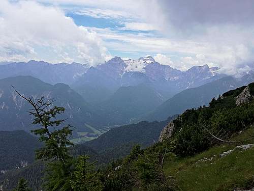
Towards Triglav massif, Julian Alps

Towards the NW
As all summits in the Karawanks, also Visoki Kurjek and Lepa Plevelnica are very panoramic. The most beautiful part of the panorama is towards the Triglav group - the highest mountain of Julian Alps is dominating the whole panorama. More to the west the other summits of Julian Alps are seen and in the W-NW direction very fine is the view on the nice summit of Kepa / Mittagskogel, with its sharp N-NE ridge and the Faaker See / Baško jezero in the background. The northern views are open and towards the E the views are flying along the long range of Karawanks.
Getting There
The most suitable accesses to the summits of Visoki Kurjek and Lepa Plevelnica are from the south, from the nice village of Dovje, 814 m, just above the valley of Sava river.
The ascents from the N and NE are possible, but long and not marked. The tours would start in the village of Rosenbach / Podrožca, or on the mountain roads, going southwards and into the ravine of Gratschenitzen / Gračenica. On the southern side, there are the following two very suitable trailheads:
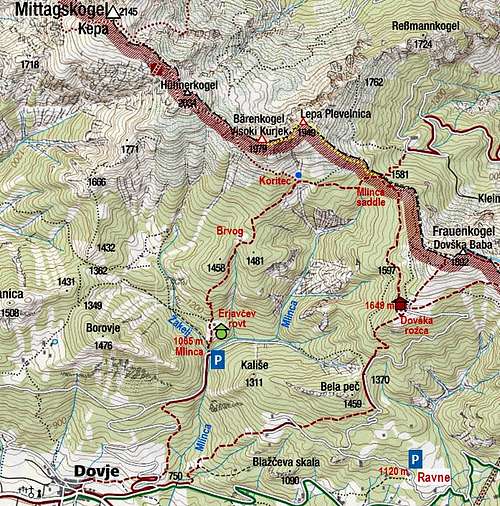
1. Road end in the Mlinca valley, 1065 m (46.479287, 13.963623). The place is known among the hikers under the name "Tromostovje". In the valley of Mlinca several creeks are coming together there. Just above the road end is the Erjavčev rovt (alpine meadow). The trailhead can be raached with car from the Dovje village. Soon above the village, on the eastern side, we deter from the mountain road left and drive up by another road. After several turns the road branches again (some 920 m) and we take the right branch there. Soon around the corner the road ends.
2. Road towards the Dovška Rožca alpine pasture. On that beautiful high pasture there's a private hut, 1649 m, which is reached by a mountain road (cart-road at the end). But the road is closed already deep down below the pasture. From the village of Dovje, we drive by the mountain road towards the east, crossing the Mlinca creek and many nice meadows. Just before the creek of Presušnik, on 1080 m, there's another crossroads. There we deter left up, towards the Ravne hamlets. Soon there is a sign, prohibiting to continue the drive. We can park there, on some 1120 m (46.469331, 13.988474), or a bit higher on the road, before the ramp, which definitely stops us to drive on.
Ascent Routes From the South
1. Mlinca road end - Mlinca saddle

From the road end in Mlinca valley, we continue by crossing the creek of Žakelj and further northward over the fence (inscription: "Kepa"). So we reach the Erjavčev rovt (meadow), continue over it and further northwards in the woods. A nice marked path goes steadily up and then a bit right across the slopes to the meadow with a cute hut - called Brvog. From there we continue further up in the NE direction, until we reach an important paths branching. There's a cute water source, so the place is called Koritec, 1601 m. The path left goes towards the summit of Kepa, while we continue right, in the eastern direction. An almost completely flat path section brings us on the Mlinca saddle, 1581 m. Easy paths (T2), good 2 hours.
2. Ravne trailhead - Mlinca saddle
From the place where we park, we simply continue by the road towards Dovška Rožca pasture. It ascends towards the north, detouring the forrested summit of Bela peč, 1460 m. On the other side of it, the road reaches the saddle, called Lahov preval, 1370 m. There the marked path leaves the road and starts ascending steeply through the woods in the northern direction. We get out of the woods on the meadows just below the shepherds hut. The continuation of the marked path towards the Mlinca saddle is above the hut. A broad path goes over the edge towards the left and then starts crossing the W slopes of Baba / Frauenkogel. With some slight ups and downs the path reaches above the Mlinca saddle and then descends on it in a long left turn. Easy paths (T2, mostly T1), 2 h 30 min. Shortcut: As the hut on Dovška Rožca is higher than the Mlinca saddle, we must lose on this route some good 100 m. The alternative may be a shepherds path wich deters left from the marked path on Dovška Rožca some 100 m below the hut and also crosses the W slopes of Baba till the Mlinca saddle.
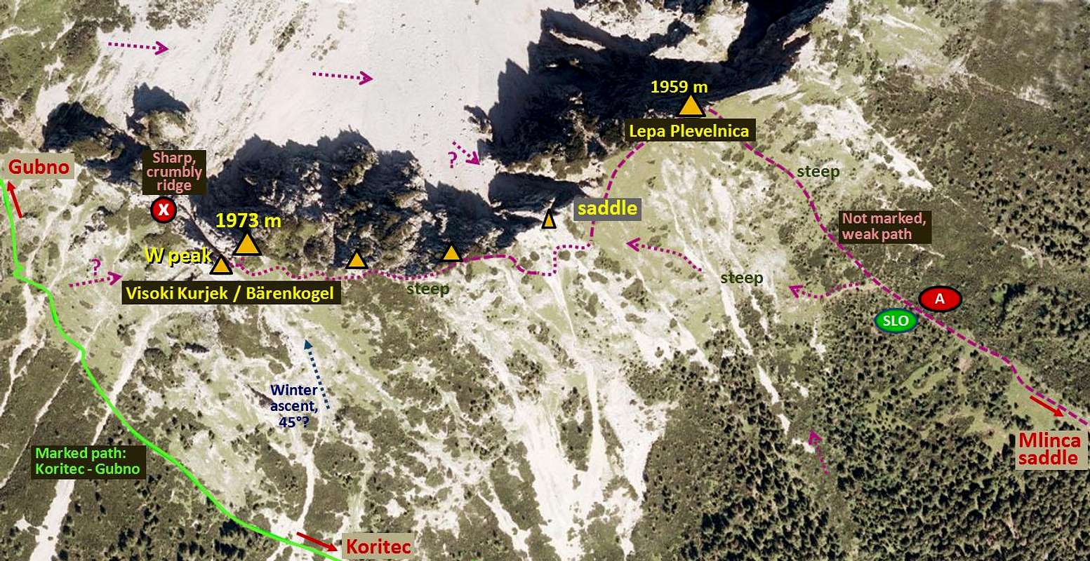
3. Mlinca saddle - Lepa Plevelnica
This is the recommended route also for the ascent further on Visoki Kurjek. From the saddle, 1581 m, we continue by nice meadows towards the NW, all the time close to the fence and the state border. At first the grassy slopes are not too steep, after the fence ends, we continue up in the same direction, following a cleaned corridor. There the grassy slopes are becoming steeper and after the corridor their inclination even increases. But besides steep slopes there are no other difficulties and in 1 hour we are on the nice summit. Difficulty: T3.
4. Lepa Plevelnica - Visoki Kurjek
From the summit of Lepa Plevelnica, 1959 m, we descend by a not steep, grassy ridge towards the SW, reaching a small saddle. That saddle could be reached from the Mlinca saddle also directly (or even from the path Koritec - Mlinca saddle), but that would require crossing some quite steep grassy and even rocky sections. Now the real ascent on Visoki Kurjek starts.
The first ridge tower must be detoured on the southern side. That may even be the hardest section of the ascent (eventually short sections of UIAA I degree climbing). Reaching by a crumbly ravine below the tower, we find there a nice passage and soon the weak trail leads us up again. So we gain the next ridge elevation and see the other two in front of us. Wherever the ridge becomes rocky or too overgrown, you just keep left of it. Crossing steep grassy slopes requires a safe step, in many sections we get "friendly hands" of dwarf pines. In another 10 minutes we reach the last ridge bump. There we may realise that we already passed the highest one. But it's good so, because to get on top of it, we simply return od the small saddle between the two and follow the steep passage, cut through the dwarf pines. Altogether 30 minutes from the Lepa Plevelnica, difficulty by the Swiss Hiking Scale is T5/T4. The saddle between the Lepa Plevelnica and Visoki Kurjek can also be reached from the north, but gaining it requires some easy climbing (up to UIAA II degree) in a crumbly terrain.
5. SW slopes
On the web trere are reports that the summit of Visoki Kurjek can also be climbed directly from the path Koritec - Kranjsko sedlo / Krainer Törl. So, not by the main ridge, but by its southern slopes, choosing best passages.
Mountain huts
The only useful hut on the southern side is the shepherds hut on Dovška Rožca alpine meadow, 1649 m. Reachable from the road closure in 1 h 30 min.
When to ascend?
The summit of Visoki Kurjek can be best climbed in dry seasons, usually between June and November. The summit of Lepa Plevelnica can however be climbed in any season. In winter and spring time the ascent requires good snow conditions. As the area of Dovška Rožca meadow and the summit of Baba above it is very popular with tour skiers, one could get an idea to do also a ski tour from lepa Plevelnica. The upper 50 meters of the slope above Mlinca saddle are very steep, below the terrains must be super. And the unpleasant part of the tour is for sure the crossing of western slopes of Baba, where we lose some 150 meters of altitude. For a base winter ascent one can choose also the south ravine of Visoki Kurjek. Its inclination is estimated on 45 degrees.