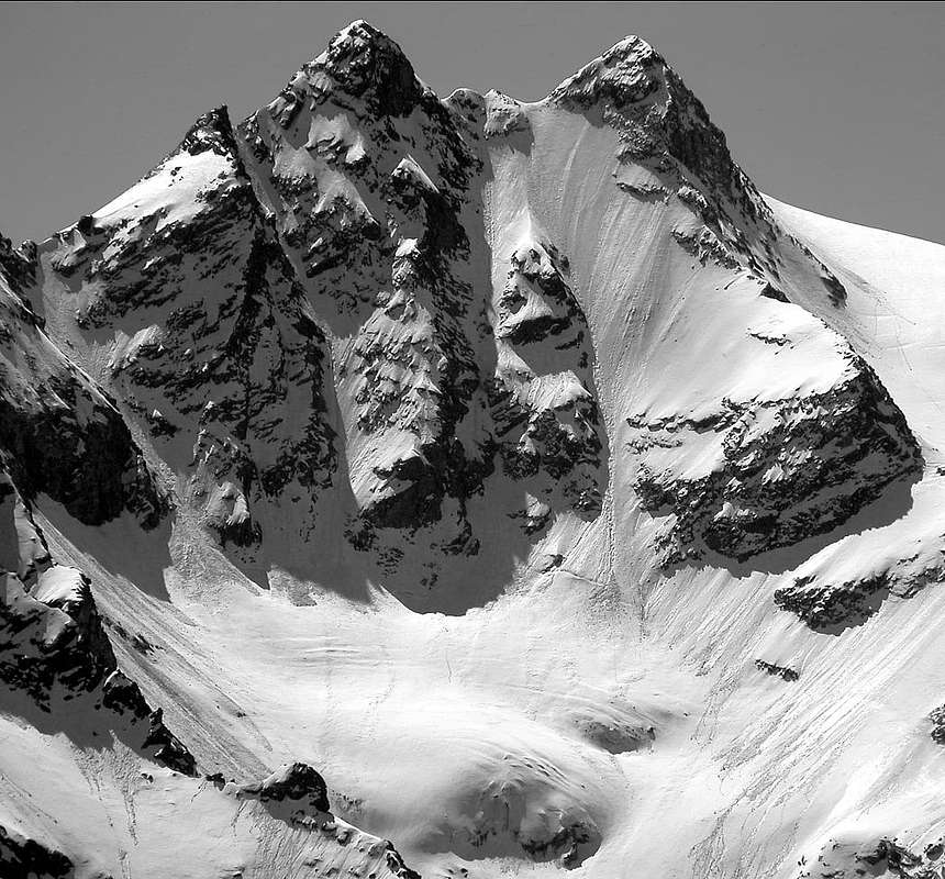
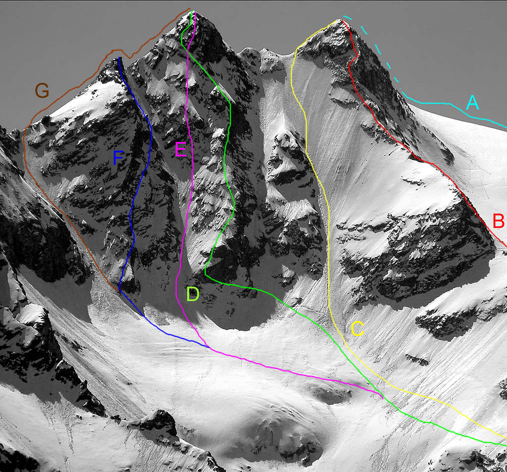
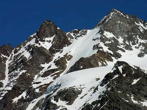
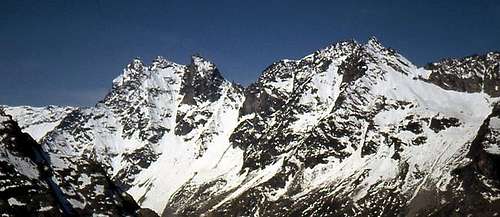
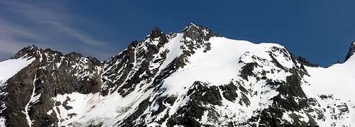
The Punte Patrì rise just North of the depression of the Col (Pass) Coupè di Money (3.393m) like a forked summit, characteristic (especially if seen from north) for its shape made by 2 parallel spurs containing the shiny iced slope of the NW wall. The S summit is about 20 meters higher than the other one, joined by a 200m long uniform but evident ridge; as well as marked by a fictitious hill (the Col de la Pène Blanche (3.516/8m) which has everything except the appearance of a pass as it is not passable, except for mountaineering). Beyond this sector (i.e. to the North of the W-NW Spur, not to be confused with the parallel that descends from Punta Meridionale or Southern Top, the highest (3.579/81 m) ) a steep snow-covered gully rises to the base of the N-NW Face of the NE Punta or Summit, the lowest (3.558/61m), reaching the North Ridge (going from Col Patrì (3.359/61m)) to a tiny notch at an altitude of about 3.470/5 meters. At the left or North end of this Western side, a triangular wall rises which culminates at an altitude of about 3.485/90 meters, between the couloir of the N-NW Face and the Northerner Crest.The ascents carried out on this face are very rare and from one end to the other they do not reach a dozen, while the "Guide of the Gran Paradiso National Park", Edit. September 1980, pp. 439/443, you forget or, at least neglect, of the beautiful NW Face, already climbed since the summer of 1965 by the Guichardaz-Cammelli roped party, and repeated in that of 1969. On the opposite or Eastern side the Punta Meridionale (Southern Summit), or also and more precisely SW but better known by the first toponym, descends above the Valeille with a wall divided into two parts (only by an attentive eye identifiable) by a rib that "turns off" between the altitudes 2.678/2.819 meters of the Northernmost sector of the Crou du Grand - Saint - Pierre, a small morainic amphitheater at the foot of the Guido Antoldi - Laura Malvezzi bivouac (2.920m). A more defined wall descends from the North or North Point which ends at an altitude 2.820 meters inside the Vallon del Gran San Pietro, a morainic amphitheater as well as parallel to the North to the previous one. A sharp and robust crest of about 1.000 meters altitude divides this slope into two distinct walls: the NE and the SE, with the first climb only once, while the second is still waiting to be explored. If the previous West side was not very popular, let's imagine this which, in addition to being completely hidden from view both from Cogne and from the Champlong and Lillaz Fractions, is wedged there at the end of the wild Valeille. Here the ascents, we are sure, can be counted on the fingertips of a single hand and, apart from the most recent ascent of July 18th 1981 on the N-NE Face of the Northern Punta, probably, the routes of Ferragosto (August holiday) 1910 on the NE Crest and of August 20th, 1937 on the nearby "Crestone" East of the Southern Punta have never been repeated; likewise, on the Punta Setttentrionale same fate for the East Crest of July 14th, 1935. Once the Age of exploration is exhausted, it is very difficult for anyone to find someone back to these parts. The SW flank is more "affordable", between the South Crest (right) and the W-NW Crest, with the latter splitting the Glacier de Patrì in two. The Normal Via climbs up on this side and is well frequented, favored not only by the ease of the route, but also by the positioning of the Money Bivouac (2.872m) at the base of an imposing ridge but secondary, originating from Dito degli Apostoli (Apostles's Finger; 3.438/9m), that divides the Upper Glacier of Patrì from the Glacier Coupé de Money. Once they were known as "La Pène Blanche", from celtic pen or Summit; unknown the source of the current place-name that should be a local creation. From the two summits a wide panorama on the whole Gran Paradiso Massif: wonderful view on the Tribolazione Glacier and Apostoli Range.
Quale coppia di punte gemelle, s'innalzano subito a Settentrione della depressione del Col Coupé di Money (3.393 m) a guisa di vetta biforcuta caratteristica, soprattutto se vista da Settentrione, per le linee costituite da due speroni paralleli, inframezzati dal lucente scivolo ghiacciato della parete Nord-Ovest, a sua volta spezzato da uno sperone incompleto (fascia di roccette alternate a brevi scivoli innevati e spesso ghiacciati). Delle due punte quella a Sud è la più elevata di circa 20 metri; la Punta Settentrionale è collegata da una cresta di 200 metri; dal profilo uniforme, ma evidente; nonché contrassegnata da un colle fittizio (il Col de la Pène Blanche (3.516/8 m) che possiede tutto tranne che l'aspetto di un colle poiché non é transitabile, se non alpinisticamente). Al di là di questo settore (cioé a Settentrione rispetto allo Sperone O-NO, da non confondere con il parallelo che però scende dalla Punta Meridionale, la più elevata (3.579/81 m) un ripido canalone innevato sale alla base della Parete N-NO della Punta NE, la meno elevata (3.558/61 m), raggiungendo la Cresta Nord (risalente dal Col Patrì (3.359/61 m)) ad un minuscolo intaglio all'altitudine di circa 3.470/5 metri. All'estremità sinistra o Nord di questo versante Occidentale, si innalza una parete triangolare che culmina a quota di circa 3.485/90 metri, compresa tra il couloir della Parete N-NO e la Cresta Nord. Rarissime sono le ascensioni svoltesi su questa parete e che da un capo all'altro non arrivano ad una dozzina, mentre la "Guida del Gran Paradiso Parco Nazionale", Edit. Sertembre 1980, pagg. 439/443, si dimentica o, perlomeno trascura, della bella Parete NO, già salita sin dall'estate del 1965 dalla cordata Guichardaz-Cammelli, nonché ripetuta in quella del 1969. Sul lato opposto od Orientale la Punta Meridionale, od anche nonché più precisamente SO ma meglio conosciuta con il primo toponimo, scende sopra la Valeille con una parete divisa in due parti (solo da occhio attento individuabili) da un costolone che si "spegne" tra le quote 2.678/2.819 metri del settore più Settentrionale del Crou du Grand - Saint - Pierre, piccolo anfiteatro morenico ai piedi del Bivacco Guido Antoldi - Laura Malvezzi (2.920 m). Dalla Punta Settentrionale o NE scende una parete più definita che termina a quota 2.820 metri dentro il Vallon del Gran San Pietro, anfiteatro gualmente morenico nonché parallelo a Nord al precedente. Un netto e robusto crestone di circa 1.000 metri d'altezza divide questo versante in due distinte pareti: la NE e la SE, con la prima salita in un'unica volta, mentre la seconda attende ancora di essere esplorata. Se già il precedente versante Ovest era poco frequentato, immaginiamoci questo che, oltre che essere completamente occultato alla vista sia da Cogne che dalle Frazioni di Champlong e Lillaz, si trova incuneato là in fondo alla selvaggia Valeille. Qui le ascensioni, ne siamo certi, si possono contare sulla punta delle dita di una singola mano ed, a prescindere dalla salita più recente del 18 luglio del1981 sulla Parete N-NE della Punta Settentrionale, probabilmente, le vie del Ferragosto 1910 sulla Cresta NE e del 20 Agosto 1937 sul vicino "Crestone" Est della Punta Meridionale non sono più state ripetute; parimenti, sulla Punta Settentrionale stessa sorte per la Cresta Est del 14 Luglio 1935. Esaurita l'Age delle esplorazioni, é ben difficile che qulcuno ripassi da queste parti. Più "abbordabile" il Versante SO, compreso tra la Cresta Sud (a destra) e la Cresta O-NO, con quest'ultima che spezza in due il Glacier de Patrì. Su questo versante sale la Via Normale che conosce una più che buona frequentazione, favorita, oltre che dalla facilità del percorso, anche dal posizionamento del Bivacco di Money (2.872 m) alla base di un notevole ed imponente crestone, ma secondario e traente origine dal Dito degli Apostoli (3.438/9 m), nonché divisorio il Glacier Superiore di Patrì dal Glacier Coupé de Money.Anticamente chiamate con il toponimo di "La Pène Blanche", dal celtico pen ovvero sommità; non è ben chiara la motivazione dell'attuale toponimo, che deve essere stato coniato in loco. Dalle due vette si gode un ampio panorama spaziante sull'intero Massiccio del Gran Paradiso: splendida la vista sul Ghiacciaio della Tribolazione e sulla Catena degli Apostoli.
First Ascents
Punta Meridionale:
First on the Summit: A., C., A. e G. Sella, Jean Joseph Maquignaz and Jean Baptiste Bich, (Aug 07th, 1881).
In winter: Ugo di Vallepiana, G. Giani and G. Grisotti, (Feb 19th, 1939).
S Arête: Agostino Ferrari, G. Lanino, G. Croux and César Ollier, (Jun 28th, 1897), in descent.
S-W Slope: A., C., A. and G. Sella, J. J. Maquignaz and J. B. Bich, (Aug 07th, 1881).
W-NW Arête: A., C., A. and G. Sella, J. J. Maquignaz and J. B. Bich, (Aug 07th, 1881), in descent.
N-NW Wall: Piero Cammelli and Antonio Guichardaz, (Aug 28th, 1965). First Repetition: Ilario Antonio Garzotto and Osvaldo Cardellina; Ruggero Busa, Carlo Vettorato and Giuseppe "Pino" Trevisan (Jul 13th, 1969)
N-E Arête: G. B. Baker, George Yeld, B. and E. Pession, (Aug 16th, 1910).
E Arête: Angelina Preisswerk Sprecher, Aldo Bonacossa and Carlo Negri, (Aug 20th, 1937).
E Wall: Laurent Dayné and Pierre Dayné, (Aug 10th, 1907), in descent.
E Wall: Aldo Bonacossa and Carlo Negri, (1937), in ascent.
Punta Settentrionale:
First on the summit: G. P. Baker, George Yeld, B. and E. Pession, ( Aug 16th 1910).
S-E Arête: G. B. Baker, George Yeld, B. and E. Pession, (Aug 16th, 1910), in descent.
NW Spur of Quota about 3.485/90 meters and N Ridge: Osvaldo Cardellina and Alessandro Cardellina, (Aug 13th, 1986).
N Arête: G. B. Baker, George Yeld, B. and E. Pession, (Aug 16th, 1910).
N-NE Wall: Osvaldo Cardellina and Marco Cossard, (Jul 18th, 1981).
E Arête: Emanuele Andreis, Luigi Bon and Ettore Passerin d'Entreves, (Jul 14th, 1935).
Getting There
BY CAR:
From Torino, Milano, etc: Motorway A5. Exit at Aosta Ovest. Drive to the near Aymavilles. Follow the directions for Valle di Cogne.
From Switzerland: through the Grand Saint Bernard Tunnel or the namesake Pass. Drive to Aosta, then follow the direction for Courmayeur on SS.26. Just after Sarre, turn to the left, in the direction of Valle di Cogne.
From France: through Mont Blanc Tunnel or Petit St. Bernard Pass. It isn't necessary to take Motorway A5: you can drive on SS.26, in the direction of Aosta.Before arriving at the Village of Sarre, turn right following the sign for Valle di Cogne. After Aymavilles, the SR.47 crosses the Villages of Vieyes, Epinel and Cretaz and after about 25 Km arrives at Cogne(1.534m). From Cogne you can get the Village of Valnontey (1.666m).
BY PLANE:
Aeroporto "Corrado Gex" Saint Christophe (Aosta).
Route
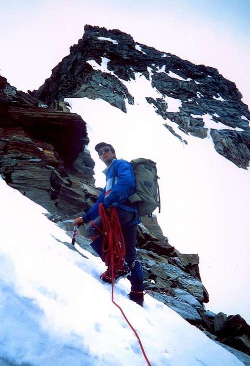
From the Village of Valnontey (1.666m) follow the easy trail going up along the valley. After the pleasant Hamlet of Valmiana (1.728m) continue, always gently uphill, till a fork (0h'45). Turn left, following the trail to the Money Hut, which begins to rise steeply. After 1h'00/1h'15 a long traverse brings one in view of the Money Hut (ruins) at 2.325 meters. Shortly before reaching them, turn left and go towards the ridge of the side moraine of the Coupé di Money Glacier. Follow the panoramic ridge of the moraine to its end, cross towards left a field of talus and broken rocks; with the help of a fixed rope climb a short gully, then a somewhat exposed path leads quickly to the bivouac, easily distinguishable since it is (or, better, it was) painted yellow. The bivouac, placed at 2.872 meters (3h'45/4h'00 hours from Valnontey), is in a very panoramic position with respect to the Gran Paradiso Central Chain. Drinkable water may be found at a short distance above the bivouac, coming from Patrì Glacier. From the bivouac on, along an easy rocky channel just above it, to get the border of the Patrì Upper Glacier; little by little toward North till the wide terrace on the West-northwest Ridge ot the Southern Summit. Down for some 100m, on the opposite side, along the steep iced slope till the bergschrund: herefrom the wall rises for about 350m with a slant of 45° (50° in the steepest part of 150m). On, beginning climbing to the right of a small rocky ridge, then straight pointing to the dip between the summits: in the last part the slope gets sweeter and sweeter. On, scrambling along the Southeast Ridge, to the Northern Summit, and/or along the easy mixed Northeast Ridge to the Southern Summit.
ALTERNATIVE ROUTE THE LEFT (1986): From terminal for 60/70m Northward towards a caracteristic gully whick, to is top, opens with a slope connecting to the 1965 way go out from a small gully to the left at the lower part of a South-Eastern Ridge of the P.ta Patrì Settentrionale. Dander of frozen surface in case of insufficent layer of snow on the rocks of the ridge in the middle of the slope. Danger of rock fall from the West-northwest Ridge.
Descent: Along the South Ridge till the upper part of Upper Glacier of Patrì, then cross horizontally toward South along a pleasant panoramic way; down using steep but easy rocks and snow slopes till the nearby of Colle Coupé di Money (3.393m), and, along the right margin of the glacier, back to the bivouac.
Dal bivacco risalire facilmente il canalone roccioso subito a monte dello stesso che deposita sul margine del Ghiacciaio Superiore di Patrì; portarsi gradualmente verso Settentrione fino al vasto "terrazzo" della cresta Ovest-NordOvest della Punta Meridionale. Scendere oltre un centinaio di metri, sul versante opposto, il ripido pendio ghiacciato giungendo nei pressi della terminale: da questo punto la parete s'innalza per circa 350 metri con pendenza 45° (50° nel tratto più ripido di circa 150 metri). Risalire tenendosi all'inizio sulla destra d'una crestina rocciosa, dopodichè si sale liberamente puntando direttamente al colletto tra le due punte; l'ultimo tratto diminuisce gradualmente in pendenza, sino a divenire pressochè camminabile e si raggiunge senza problema il colletto. Risalire la cresta Sudest per roccette sino alla vetta della Punta Settentrionale dalla quale, dopo essere ridiscesi, si attraversa a quella Meridionale risalendone la facile crestina Nordest per rocce e neve.
VARIANTE DI SINISTRA (1986): Dalla terminale portarsi 60/70 metri più a Nord in direzione di un caratteristico canalino, che in alto si apre in pendio aperto collegandosi alla via del 1965. Uscire per un canaletto a sinistra proprio alla base della Cresta Sudest della Punta Patrì Settentrionale (più esposto a cadute di pietre dal crestone Ovest-nordovest), possibilità di verglass in caso di scarso innevamento, sugli affioramenti rocciosi della crestina centrale allo scivolo.
Discesa: Scendere dapprima per la cresta Sud sino al sommo del Ghiacciaio Superiore di Patrì e traversare poi orizzontalmente verso Meridione su tranquillo percorso panoramico; ridiscendere per le rocce abbastanza ripide e facili alternate a nevai sin nei pressi del Colle Coupé di Money (3.393 m), dal quale per il margine destro orografico dell'omonimo ghiacciaio si cala al bivacco.
Difficulties
Normal route: F+.
N-NW Wall: (right route, 1965) AD.
W-NW Wall: (left route, 1986) AD+.
Equipment
Mountaineering equipment, including rope, ice axe, and crampons.
Huts
From Cogne: Bivacco del Money (2.872m).
Campings
Wild camping in the Parco Nazionale del Gran Paradiso is strictly forbidden! There are three camping sites very near to Valnontey Village. The most appropriate support point is the Money Bivouac.
Red Tape
Within the borders of the P.N.G.P. (Parco Nazionale del Gran Paradiso), at the moment (summer 2004), dogs generally are not allowed, except on a couple of trails, and camping is forbidden (except for climbers from sunset till dawn). No fees are due.
Mountain Condition
Meteo: you can find all the needed informations at the official site of the Valle d'Aosta Region:
"Guida delle Alpi Occidentali", di Giovanni Bobba e Luigi Vaccarone C.A.I. Sezione di Torino Volume II (parte II), 25 Maggio 1896.
"80 itinerari di Escursionismo Alpinismo e Sci Alpinismo in Valle d'Aosta", di Osvaldo Cardellina, Ed. Musumeci, Giugno 1977 (in Italian); seconda Ed. Luglio 1981; terza Ed. Luglio 1984; (in French), prima Ed. Febbraio 1978; seconda Ed. Marzo 1980.
"Guida della Regione Autonoma Valle d'Aosta", di Mario Aldrovandi; Ed. S.P.E. di Carlo Fanton, Torino 1964.
"Rifugi e bivacchi in Valle d'Aosta", di Cosimo Zappelli aggiornata da Pietro Giglio, Musumeci Editore, Luglio 2002.
"Guida dei Monti d'Italia-Gran Paradiso Parco Nazionale" E. Andreis, R. Chabod, M. C. Santis, Club Alpino Italiano/Touring Club Italiano, prima Ed. 1939; seconda Ed. 1963; terza Ed. 1980.
"Il Parco Nazionale del Gran Paradiso (Valli di Champorcher-Clavalitè-Saint Marcel-Laures-Cogne-Valsavarenche-Conca di Pila", di Giulio Berruto 3/volume 2°, IGC Torino; prima Ed. 1981; seconda Ed. 2000 (in Italian).
"Gran Paradiso", A. Gegenfurtner, G. Klotz, F. Müller, Ed. Bergverlag Rudolf Rother, Monaco 1980 (in tedesco).
"Gran Paradiso", G. Klotz, Ed. Bergverlag GmbH Rother, Monaco 2005 (in tedesco).
"Gran Paradiso", di Pierandrea Mantovani e Renato Misischi, Ed. Rassegna Alpina, 1974.
"Gran Paradiso-Itinerari Alpinistici e Sci Alpinistici", di Franco Brevini, Ed. Musumeci, Giugno 1982.
"Diari Alpinistici" di Osvaldo Cardellina e Indice Generale accompagnato da Schedario Relazioni Ascensioni 1964-2019 (inediti).
MAPS:
Kompass "Gran Paradiso Valle d'Aosta Sentieri e Rifugi" Carta Turistica 1:50.000.
SIRIO Blue Vision "Cogne Valnontey" Carte fotografiche.
A.I.NE.VA. (Associazione Interregionale Neve e Valanghe).
A.IA.T. Cogne Gran Paradis via Bourgeois n° 34 Tel. 0165-74040. E-mail: aiat@cogne.org
Ezio Sport articoli sportivi - via Bourgeois n° 64 Tel. 0165-74204.
Useful numbers
Soccorso Alpino Cogne (SAR) Tel. 3482685406.
Protezione Civile Valdostana località aeroporto n° 7/A Saint Christophe (Ao) Tel. 0165-238222.
Bollettino Meteo (weather info) Tel. 0165-44113.
Unità Operativa di Soccorso Sanitario Tel. 118.
Acknowledgements
I am greatly indebted to my friend "Osva" for the detailed description of the route and all texts. In addition I want to thank Gabriele Roth for the translation of the text from italian.
Parents refers to a larger category under which an object falls. For example, theAconcagua mountain page has the 'Aconcagua Group' and the 'Seven Summits' asparents and is a parent itself to many routes, photos, and Trip Reports.

 12754 Hits
 88.61% Score
 27 Votes