
-
 6799 Hits
-
 89.01% Score
-
 28 Votes
|
|
Mountain/Rock |
|---|---|
|
|
45.52130°N / 7.33719°E |
|
|
Mountaineering |
|
|
11831 ft / 3606 m |
|
|
Overview
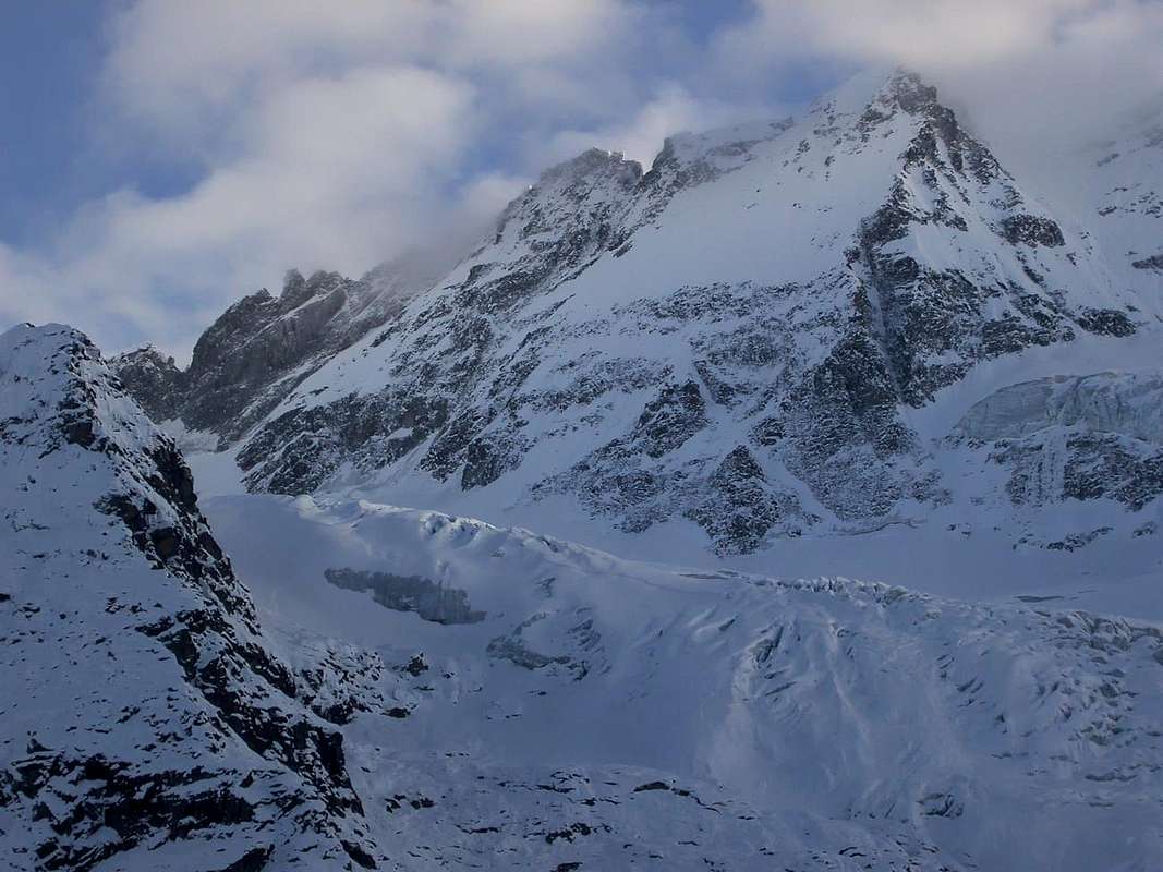
Atypical pyramid, made by only two ridges, on the boundary between Valle d'Aosta and Piemonte. The long East Ridge, after the "Colle della Pazienza" and the "Testa di Money", turns toward the "Colle di Money" and raises in the "Apostoli Group" - The Southwest one, after the "Gemelli", binds to the "Roccia Viva". From the Summit an interesting panorama on the Gran Paradiso, the Apostoli Group and the close Roccia Viva.
 |
Piramide atipica formata da sole due creste sul confine Valle d'Aosta/Piemonte. La lunga cresta Est, dopo il Colle della Pazienza e la Testa di Money, s'indirizza verso il Colle di Money e si rialza nel Gruppo degli Apostoli; quella Sud-Ovest, dopo i "Gemelli", si lega alla Roccia Viva. Dalla vetta si gode d'un interessante panorama sul Gran Paradiso, il Gruppo degli Apostoli e la vicina Roccia Viva.
First Ascents
- First on the summit SE Wall and SW Arête: G. Yeld, F. Pession and A. Pellissier, (Aug 06th, 1892).
- In winter: Unknown.
- E Arête: G. and S. Delmastro and P. Rosso, (Aug 11th, 1937).
- SW Arête: L. and M. Borelli and G. Dumontel, (Jul, 1907).
- NW Wall: G. Tonella and E. K. Esslinger, (Jul 31th, 1926).
- NE Wall: F. Nagele, G. Perugini and Toni Usmiani, (Jul 12th, 1939).
Getting There
BY CAR:
- From Torino, Milano, etc: Motorway A5. Exit at Aosta Ovest. Drive to the near Aymavilles. Follow the directions for Valle di Cogne.
- From Switzerland: through the Grand Saint Bernard Tunnel or the namesake Pass. Drive to Aosta, then follow the direction for Courmayeur on SS.26. Just after Sarre, turn to the left, in the direction of Valle di Cogne.
- From France: through Mont Blanc Tunnel or Petit St. Bernard Pass. It isn't necessary to take Motorway A5: you can drive on SS.26, in the direction of Aosta.Before arriving at the Village of Sarre, turn right following the sign for Valle di Cogne. After Aymavilles, the SR.47 crosses the Villages of Vieyes, Epinel and Cretaz and after about 25 Km arrives at Cogne (1.534m). From Cogne you can get the Village of Valnontey (1.666m).
BY PLANE:
- Aeroporto "Corrado Gex" Saint Christophe (Aosta).
Route to the Money Bivouac
From Cogne (1.534m) along the road (public bus or by car) to Valnontey (1.666m - wide car parking). Along the Valnontey on its left side (East) and after the fine Pastures of Valmiana (1.728m) follow the path till the fork (0h'45) that, on the left, leads to the Money Houses. After about 2 hours walk you can see the Money and, little before getting there, keeping the left side, ascend along some morainic slopes and along the ridge of the lateral moraine (orographic right of the Coupè di Money Glacier). Along the moraine on small tracks, where it ends cross to the left a small valley of debris and broken rocks, up along a short but steep slope of rocks (anchors and chains) to get the well visible (yellow) Bivouac (2.872m - 1h'15 from Money Alpage). Little above the bivouac (anchors and chains) you can find the water coming out from Patrì Glacier. From the Money Bivouac reach the Coupé di Money glacier and ascend it in the southeast direction towards Cresta Paganini (3.440m). Go around the ridge at its base at about 3.200 meters of elevation (beware the crevasses!) and reach the Money Pass (3h'30/4h'00). From the col follow the long Money Ridge passing spires and gullies and reaching, in succession, Campanile di Money, Testa di Money, (3.572m) and Cresta Barale. Rappel to Colle della Pazienza (3.567m); pass a tower on rock and snow and, shortly after, reach the Summit (7h'00 from the bivouac).
Descend: retracing your steps.
Dall'abitato di Cogne (1.534 m) in Bus o in auto sino a Valnontey (1.666 m) ove si parcheggia nell'ampio piazzale, salire la Valnontey sul versante della destra orografica e superato l'ameno alpeggio di Valmiana (1.728 m) si prosegue per il sentiero sino al bivio che sale verso sinistra per i casolari del Money (0h'45). Dopo circa 2h'00 si notano i sopracitati casolari posti a 2.325 m; poco prima di raggiungerli sempre sulla sinistra superare alcuni pendii morenici risalire il dorso della morena laterale (destra orografica del Ghiacciaio di Coupé di Money). Salire la morena sulla cresta su poco evidenti tracce di sentiero, alla fine della stessa attraversare verso sinistra una piccola valle di sfasciumi e rocce rotte, superare il breve tratto di rocce abbastanza ripide (con l'ausilio di alcune catene fisse) che precedono di poco il bivacco posto a 2.872 m (1h'15 dai casolari del Money). Il bivacco è di colore giallo. Acqua: proveniente dal Ghiacciaio di Patrì si può trovare poco sopra il bivacco raggiungibile sempre con l'ausilio di catene fisse. Dal Bivacco del Money raggiungere il Ghiacciaio di Coupé di Money e risalirlo in direzione Sud-Est verso la Cresta Paganini (3.440 m). Doppiare la cresta alla base a circa 3.200 metri di quota (attenzione ai crepacci!) e raggiungere il Colle di Money (3.443 m), (3h'30/4h'00). Dal Colle percorrere la lunga cresta di Money superando le varie asperità e raggiungendo in successione il Campanile di Money, la Testa di Money (3.572 m) e la Cresta Barale. Scendere al Colle della Pazienza (3.567 m) con una "doppia"; superare un torrione per rocce e neve e in breve in vetta (7h'00) dal bivacco.
Discesa: dalla stessa via di salita.
Route to the Martinotti Bivouac
From Valnontey (1.666m) follow the path till to the fork at 2.040m (1h'15/2h'00): give up the right branch leading to all the other bivouacs of the area, turn left instead and follow the signs till to the Bivouac Alessandro Martinotti (2.588m), not visible during the ascent (2h'30/3h'00 hours). From the Bivouac A. Martinotti, to easily go up the Money Glacier (beware the crevasses!) up to the homonym Pass (3.443m), (3h'00). From the Pass it travel the long Cresta di Money surpassing the varied roughness and reaching in succession the Campanile (Bell Tower) di Money, the Testa di Money (3.572m) and the Cresta Barale. To come down the Colle della Pazienza (3.567m) with a "double"; to surpass a tower for rocks and snow and in short in peak (7h'00) from the bivouac.
Descend: retracing your steps.
Da Cogne (1.534 m) in Bus o in auto sino a Valnontey ove si parcheggia, proseguendo per il sentiero sino al bivio (2.040 m) (ore 1h'15/2h'00) per i bivacchi Carlo Pol (3.183 m) - Gérard, Grappein (3.200 m) – Martinotti (2.588 m) – Stefano Borghi (2.686 m) – Lionello e Lucio Leonessa (2.910 m); volgere a sinistra per cespugli sin presso il torrente, dove si lascia destra un sentiero per deviare su di un secondo siglato da bolli. Attraversare il torrente su di un ponticello. Seguire, mancando una traccia sicura sul pendio morenico, le segnalazioni sino ad un valloncello che termina sotto lo spalto roccioso alla base del crestone nord-ovest della Roccia Viva. Con traversata a sinistra con bella vista sulla morena ed il fronte del Ghiacciaio di Gran Crou, si segue infine un pendio erboso che porta brevemente al ripiano, sotto un salto roccioso, dove si trova il bivacco A. Martinotti (2.588 m) (ore 2h'30/3h'00) non visibile durante la salita. Dal bivacco A. Martinotti, risalire facilmente il Ghiacciaio di Money (attenzione ai crepacci!) fino al Colle omonimo (3.443 m), (3h'00). Dal Colle percorrere la lunga cresta di Money superando le varie asperità e raggiungendo in successione il Campanile di Money, la Testa di Money (3.572 m) e la Cresta Barale. Scendere al Colle della Pazienza (3.567 m) con una "doppia"; superare un torrione per rocce e neve e in breve in vetta (7h'00) dal bivacco.
Discesa: dalla stessa via di salita.
Difficulties
This route can be considered PD-/AD+ (depending on mountain and ice conditions).
L'itinerario è classificato da PD-/AD+ (dipende dalle condizioni della montagna).
Equipment
High mountain equipment: including rope, helmet, frontal torch, ice axe, and crampons.
Da alta montagna: Picozza, ramponi, corda, casco e lampada frontale.
Huts
- Bivacco del Money (2.872m).
- Bivacco Alessandro Martinotti (2.588m).
Red Tape
Within the borders of the P.N.G.P. (Parco Nazionale del Gran Paradiso), at the moment (summer 2004), dogs generally are not allowed, except on a couple of trails, and camping is forbidden (except for climbers from sunset till dawn). No fees are due.
 |
 |
 |
 |
Campings
- Wild camping in the Parco Nazionale del Gran Paradiso is strictly forbidden!!! There are three camping sites very near to Valnontey Village. The most appropriate support point is the Money and Martinotti Bivouac.
Mountain Condition
- Meteo: you can find all the needed informations at the official site of the Valle d'Aosta Region:
- Valle d'Aosta Meteo
- Meteo: You can find more weather information on the website 3B Meteo:
- Meteo Cogne
- Meteo: You can find more weather information on the website 3B Meteo:
- Meteo Valnontey
Webcam
- WEBCAM on Aosta Valley:
- Webcam
Books and Maps
BOOKS:
- "Guida delle Alpi Occidentali" di Giovanni Bobba e Luigi Vaccarone C.A.I. Sezione di Torino Volume II (parte II), 25 Maggio 1896.
- "Guida dei Monti d'Italia-Gran Paradiso Parco Nazionale" E. Andreis, R. Chabod, M. C. Santis, Club Alpino Italiano/Touring Club Italiano, prima Ed. 1939; seconda Ed. 1963; terza Ed.
- "I Rifugi della Valle d'Aosta" di Stefano Ardito, Ed. Guide iter, Febbraio 2003.
- G. Berutto "Il Parco Nazionale del Gran Paradiso" III°, volume 2° Ed. I.G.C. Torino 1981, 2000.
- "Gran Paradiso - Itinerari Alpinistici e sci Alpinistici" di Franco Brevini Ed. Musumeci, Giugno 1982.
- "Gran Paradiso" di Pierandrea Mantovani e Renato Misischi, Ed. Rassegna Alpina, 1974.
- A. Gegenfurtner, G. Klotz, F. Müller "Gran Paradiso", Ed. Bergverlag Rudolf Rother, Monaco 1980 (in tedesco).
- G. Klotz "Gran Paradiso" Ed. Bergverlag GmbH Rother, Monaco 2005 (in tedesco).
 |
 |
 |
 |
MAPS:
- Kompass "Gran Paradiso Valle d'Aosta" Sentieri e Rifugi Carta turistica 1:50.000.
- I.G.C. Istituto Geografico Centrale "Gran Paradiso La Grivola" Carta 1:25.000.
- L'Escursionista "Valle di Cogne Carta dei Sentieri" (n° 10) 1:25.000.
- L'Escursionista "Tour de la Vallée de Cogne Grand Paradis" Carta dei sentieri 1:25.000.
- I.G.C. Istituto Geografico Centrale "Il Parco Nazionale del Gran Paradiso" 1:50.000.
- I.G.M. Istituto Geografico Militare Foglio 41 I SO Gran Paradiso - I NE Cogne 1:25.000.
- A.I.A.T. Cogne Gran Paradiso "Gran Paradiso Cogne Aymavilles" Walking map 1:25.000.
- Enrico Editore Ivrea "Gruppo del Gran Paradiso" 1:50.000.
- Studio F.M.B. Bologna "Gran Paradiso" 1:50.000.
Important Information
- REGIONE AUTONOMA VALLE D'AOSTA the official site.
- FONDAZIONE MONTAGNA SICURA Villa Cameron, località Villard de la Palud n° 1 Courmayeur (AO) Tel: 39 0165 897602 - Fax: 39 0165 897647.
- SOCIETA' GUIDE ALPINE DI COGNE Tel. 347/9473526 – 328/1373728.
- A.I.NE.VA. (Associazione Interregionale Neve e Valanghe).
- A.IA.T. Cogne Gran Paradis via Bourgeois n° 34 Tel. 0165-74040. E-mail: aiat@cogne.org
- Ezio Sport articoli sportivi - via Bourgeois n° 64 Tel. 0165-74204.
Useful numbers
- Soccorso Alpino Cogne (SAR) Tel. 3482685406.
- Protezione Civile Valdostana località Aeroporto n° 7/A Saint Christophe (Ao) Tel. 0165-238222.
- Bollettino Meteo (weather info) Tel. 0165-44113.
- Unità Operativa di Soccorso Sanitario Tel. 118.