
-
 11179 Hits
-
 90.13% Score
-
 31 Votes
|
|
Mountain/Rock |
|---|---|
|
|
45.52560°N / 7.26724°E |
|
|
Mountaineering |
|
|
12881 ft / 3926 m |
|
|
Overview
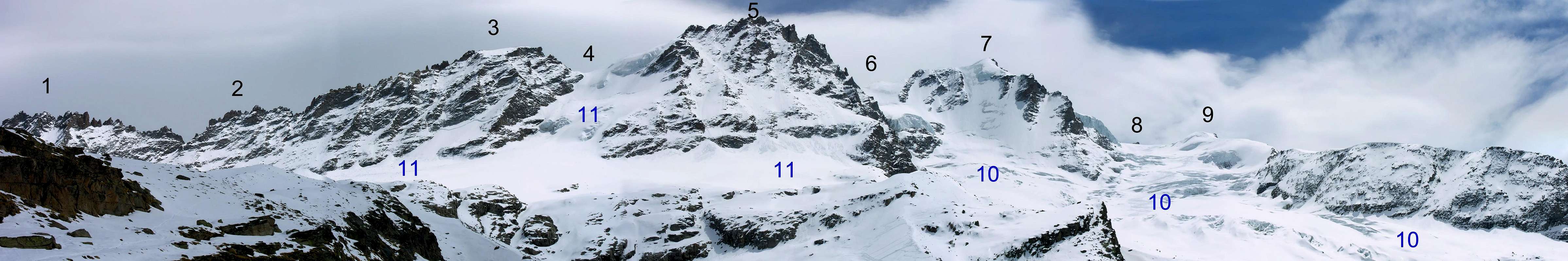
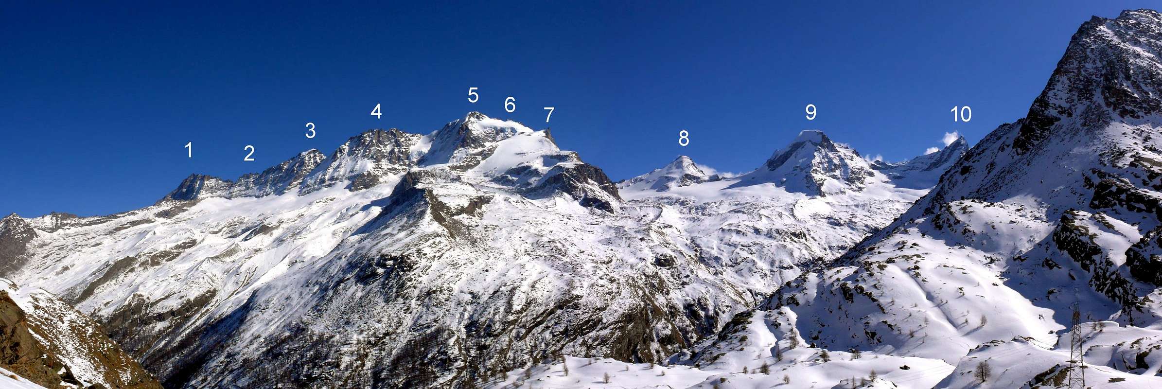
Fine Summit, obscured only by the close Gran Paradiso (4.061m), the highest Summit of the group and the only one over 4.000m entirely in Italy. The Piccolo Paradiso is joined, to the North, to the ridge that hosts the Becca di Montandayné (3.838m), the Herbetet (3.778m), the Grand Serz or Gran Serra (3.552m), the Grivola (3.969m) and the Grand Nomenon (3.488m). It has three Summits, he first of which is twofold: the Southern one aka Punta P. G. Frassy (3.926m), the Central one aka Punta Punta Joseph P. Farrar (3.921m) and the Northern one aka Punta Luigi Vaccarone (3.868m). Along the summital ridge some more minor but important summits.
Bella montagna, oscurata soltanto dal vicino Gran Paradiso (4.061 m), massima cima dell'intero gruppo ed unica vetta superante i 4.000 metri completamente in territorio italiano. Il Piccolo Paradiso le è subito accollato a Nord, nella catena che poi forma la Becca di Montandayné (3.838 m), l'Herbetet (3.778 m), il Grand Serz o Gran Serra (3.552 m), la Grivola (3.969 m) e il Grand Nomenon (3.488 m). E' formata da tre Punte, delle quali la prima é duplice: le Meridionali Sud e Nord o Punta P.G. Frassy (3926 m), la Centrale o Punta Joseph P. Farrar (3.921 m) e la Settentrionale o Punta Luigi Vaccarone (3.868 m). Sulla cresta sommitale vi sono altre importanti quote non nominate.
First Ascents
Punte Meridionali:- First in the summit (NE Wall and E Arête): P. G. Frassy and E. Jeantet, (Aug 03th, 1869).
- S Arête: E. Javelle, J. Mooser and F. Fournier, (Jul 20th, 1876), in descent.
- S Arête: G. Bobba, L. Cibrario, L. Vaccarone, C. Thèrisod and P. Re Fiorentin, (Aug 08th, 1891), in ascent.
- W Wall (from Montandayné Glacier of Quota 3.919m): P. G. Frassy and E. Jeantet, (Aug 03th, 1869), in descent.
- W Wall (from Montandayné Glacier of Quota 3.923m): Eugéne Bron and companions, (1950?), in ascent.
- NW Arête (from Punta Centrale or Farrar): J. P. Farrar, D. Maquignaz and Köderbacher Junior, (Aug 13th, 1898), in descent.
- NW Arête (from Punta Centrale or Farrar): E. Backhouse, M. J. Chabod and A. A. Dayné, (Sep 14th, 1908), in ascent.
- E Wall and N Arête: J. Ittlinger and two companions, (1908)?.
- NE Wall: Franck and Schumann, (Aug 17th, 1908).
- NE Wall: G. Yeld, A. Payot and L. Guichardaz, (Aug 11th, 1879).
- NE Wall (direct route): P. Cammelli and A. Guichardaz, (Aug 08th, 1976).
- First on the summit(SE Arête): J. P. Farrar D. Maquignaz and Köderbacher Junior, (Aug 13th, 1898).
- First on the summit: L. Vaccarone, A. Castagneri and A. Boggiatto, (Jun 16th, 1875).
![]()
Getting There
BY CAR: Valle di Cogne- From Torino, Milano, etc: Motorway A5. Exit at Aosta Ovest. Drive to the near Aymavilles. Follow the directions for Valle di Cogne.
- From Switzerland: through the Grand Saint Bernard Tunnel or the namesake pass. Drive to Aosta, then follow the direction for Courmayeur on SS.26. Just after Sarre, turn to the left, in the direction of Valle di Cogne.
- From France: through Mont Blanc Tunnel or Petit St. Bernard Pass. It isn't necessary to take Motorway A5: you can drive on SS.26, in the direction of Aosta. Before arriving at the Village of Sarre, turn right following the sign for Valle di Cogne. After Aymavilles, the SR.47 crosses the Villages of Vieyes, Epinel and Cretaz and after about 25 Km arrives at Cogne (1.534m).
- From Cogne you can get the Village of Valnontey (1.666m).
BY CAR: Valsavarenche
- From France, through the Mont Blanc Tunnel or the Col du Petit Saint Bernard: you can drive on SS.26, following the direction for Aosta and, before arriving in Villeneuve, turn right towards Introd. Alternatively, you can take Motorway A5 (at Courmayeur or Morgex) and exit at Aosta Ovest.
- From all other directions: get to the Aosta Ovest exit of Motorway A5. Then drive along SS.26 Aosta, direction Courmayeur, and just after Villeneuve turn left towards Introd. Shortly after Introd, you arrive at a junction: turn left, entering in Valsavarenche and then, before arriving at Pont (1.978m) where the road ends, you will touch the Villages (Degioz, Eaux Rousses, etc) where the pathways to "Casolari" Superiori di Leviona, Sberna Bivouac, Chabod Refuge start from.
BY PLANE:
- Aeroporto "Corrado Gex" Saint Christophe (Aosta).

|

|

|
Route
First day: From Cogne (1.534m) one quickly reaches the Hamlet of Valnontey (1.666m) where parking is available in the large square near the center of the village. Start the ascent on the orographic right (climber's left) of Valnontey. Once past the Hamlet of Valmiana (1.728m), reach the Erfaulet Bridge at (1.830m). Cross the bridge and continue along the trail until a fork at (2.040m) (1h'40/2h'00). Take the right branch, cross a small bridge and climb along a winding path to the "Casolari dell'Herbetet" at (2.435m). Here you will find a hut of the Gran Paradiso National Park. Continue along the steeper winding trail that climbs the grassy slopes. Once in the upper Herbetet Valley, keep slightly left; once across the Herbetet Brook, climb again in the direction of the morainic ridge surmounted by the East Ridge of Herbetet (Follow the signs!). In its vicinity you will find the fixed Bivouac named after the brothers Lucio and Lionello Leonessa (2.910m) sleeps-12, (4h'15/4h'45 from Valnontey). Be warned that in summer the bivouac may be crowded and that it may be hard to find in the dark or in the fog.
Primo Giorno: Dall'abitato di Cogne (1.534 m) in bus o in auto sino a Valnontey (1.666 m), ove si parcheggia nel grande piazzale sito quasi al centro della frazione, iniziare la salita sul versante della destra orografica e superato l'ameno Alpeggio di Valmiana (1.728 m). si giunge al Ponte dell'Erfaulet (1.830 m); lo s'attraversa e si prosegue per il sentiero sino al bivio 2.040 m (ore 1h'40/2h'00). Seguire il sentiero verso destra, oltrepassare un ponticello e superare gli ultimi balzi che portano ai Casolari dell’Herbetet (2.435 m), dove è sita la casa del P.N.G.P. Continuare a seguire il sentiero che risale il dosso erboso e, giunti sulla parte superiore del Vallone dell'Herbetet, tenersi leggermente sulla sinistra e, dopo aver attraversato un torrentello, riprendere a risalire in direzione del dorso morenico dominato dal Costone Est dell'Herbetet nelle cui vicinanze è posto il nuovo bivacco del C.A.I. Lionello Leonessa (2.910 m), 12 posti letto. (ore 4h'15/4h'45 da Valnontey). Attenzione nella bella stagione il bivacco può essere sovraffollato da numerosi alpinisti e escursionisti ed è inoltre difficile da trovare al buio o con la nebbia.
Second Day: Go to the South toward the Morains of Tsasset and of Tribolazione and pass it getting the Tribolazione Glacier; along it first in the Southwest, near the rocks to pass over the seracs, then, at 3.100 meters, in the Southeast trying to find the best track (changing every year due to the flow of the glacier) to get the upper plain of the Tribolazione Glacier at 3.500 meters about. This step, paying attention to the falling stones, can be passed also more to the West, near the walls between the Becca di Montandaynè and the Piccolo Paradiso. Now, always toward South climb the slopes toward the Northeast Wall and along it and the Eastern snow Ridge get the South Summit of the Punta Frassy (3.919m) then the North Summit or Punta Frassy (3.926m), the highest one.
Secondo Giorno: Dirigersi a Sud verso la Morena di Tsasset e quella della Tribolazione e scavalcarla toccando l'omonimo ghiacciaio; salire appoggiandosi dapprima a Sudovest contro le rocce per superare le seraccate, poi a Sudest a quota 3.100 m~ e destreggiandosi (il percorso varia molto negli anni con il movimento dei ghiacci) raggiungere il pianoro superiore del Ghiacciaio della Tribolazione a quota 3.500 m~. Questo tratto a volte, ma facendo molta attenzione alle scariche di pietre, può essere più conveniente percorrerlo più ad Ovest contro la bastionata tra la Becca di Montandaynè ed il Piccolo Paradiso. Sempre con direzione Sud risalire il pendio nella direzione della parete Nordest e per questa e la nevosa Crestina Orientale salire alla Punta Sud delle Pointes Meridionales (3.919 m) e alla Punta Nord o Frassy (3.926 m), la più elevata.
Coming down
Coming down:- A) - Along the same route.
- B) - Along the S ridge to the Colle del Piccolo Paradiso (3.870m) and the East channel down to the Tribolazione Glacier.
- C) - Along the NE ridge up to the summit of Gran Paradiso (4.061m), wonderful but to be made only with fine weather. From Gran Paradiso down to the Roc (4.026m) and down to the Tribolazione Glacier.
- D) - From Gran Paradiso along the normal route (Southwest Side) down to Pont di Valsavarenche.
Discesa:
- A) - Lungo l'itinerario di salita.
- B) - Per la cresta Sud al Colle del Piccolo Paradiso (3.870 m) e il couloir Est al Ghiacciaio della Tribolazione.
- C) - Continuando sulla cresta NE raggiungere la vetta del Gran Paradiso (4.061 m), itinerario splendido e tecnico ma richiede assoluta rinuncia in caso del cambiamento del tempo. Dal Gran Paradiso al Roc (4.026 m) e da questo al Ghiacciaio della Tribolazione.
- D) - Dal Gran Paradiso a Pont di Valsavarenche per il Versante Sudovest (Via Normale).
Difficulty
The route can be classified as PD+ or AD- depending on mountain conditions, to be done only by experienced and trained climbers.L'itinerario è classificato PD+ (Poco Difficile+) ad AD- (Abbastanza Difficile-) dipende dalle condizioni della montagna, si consiglia ad alpinisti allenati ed esperti.
Gear
High mountain gear: rope, iceaxe, crampons, helmet and torch.Fixed Bivouac Lucio and Lionello Leonessa (2.910m), near Herbetet's east ridge. Difficulty: E (Hikers). Reachable from Valnontey (see the following itinerary).
- Bivacco Leonessa (2.910 m) Upper Vallone dell'Herbetet
 |
 |
Federico Chabod Hut (2.750m), just near Costa Savolera, on the orographic right of Valsavarenche. Difficulty: E (Hikers) sleeps 40 (in winter it sleeps 16).
- Rifugio Federico Chabod (2.750 m) Côte Savolère di Montandayné (Valsavarenche) Tel.: 0039/0165/95574 eMail: info@rifugiochabod.com
 |
 |
Red Tape
Within the borders of the P.N.G.P. (Parco Nazionale del Gran Paradiso), at the moment dogs generally are not allowed, except on a couple of trails, and camping is forbidden (except for climbers from sunset till dawn). No fees are due.Campings
- Wild camping in the Parco Nazionale del Gran Paradiso is strictly forbidden!!! There are three camping sites very near to Valnontey Village.
Mountain Conditions
- Meteo: you can find all the needed informations at the official site of the Valle d'Aosta Region:
- Valle d'Aosta Meteo
- Meteo: You can find more weather information on the website 3B Meteo:
- Meteo Cogne
- Meteo: You can find more weather information on the website 3B Meteo:
- Meteo Valsavarenche
Webcam
- WEBCAM on Aosta Valley:
- Webcam
Books and Maps
BOOKS:- "I Rifugi della Valle d'Aosta" di Stefano Ardito, Ed. Guide iter, Febbraio 2003.
- "Parco Nazionale del Gran Paradiso" di Stefano Ardito, Ed. Guide iter, Novembre 2001.
- "Guida delle Alpi Occidentali", di Giovanni Bobba e Luigi Vaccarone C.A.I. Sezione di Torino Volume II (parte II), 25 Maggio 1896.
- "Gran Paradiso", A. Gegenfurtner, G. Klotz, F. Müller, Ed. Bergverlag Rudolf Rother, Monaco 1980 (in tedesco).
- "Gran Paradiso", G. Klotz, Ed. Bergverlag GmbH Rother, Monaco 2005 (in tedesco).
- "Diari Alpinistici" di Osvaldo Cardellina e Indice Generale accompagnato da Schedario Relazioni Ascensioni 1964-2019 (inediti).
- "Rifugi e bivacchi in Valle d'Aosta", di Cosimo Zappelli aggiornata da Pietro Giglio, Musumeci Editore, Luglio 2002.
- "Guida della Regione Autonoma Valle d'Aosta" di Mario Aldrovandi,Ed. S.P.E. di Carlo Fanton, Torino 31 Dicembre 1964.
- "Guida dei Monti d'Italia-Gran Paradiso Parco Nazionale" E. Andreis, R. Chabod, M. C. Santis, Club Alpino Italiano/Touring Club Italiano, prima Ed. 1939; seconda Ed. 1963; terza Ed. 1980.
 |
 |
 |
 |
 |
- Kompass "Gran Paradiso Valle d'Aosta Sentieri e Rifugi" Carta Turistica 1:50.000.
- L'Escursionista "Valsavarenche Gran Paradiso Carta dei Sentieri" (n° 9) 1:25.000.
- Meridiani Montagne "Gran Paradiso" 1:25.000.
- Enrico Editore Ivrea-Aosta "Gruppo del Gran Paradiso" 1:50.000.
- L'Escursionista "Valle di Cogne Carta dei Sentieri" 1:25.000.
- L'Escursionista "Tour de la Vallée de Cogne Grand Paradis" 1:25.000.
- I.G.C. Istituto Geografico Centrale "Parco Nazionale del Gran Paradiso" 1:50.000.
- Studio F.M.B. "Gran Paradiso" Bologna 1:50.000.
- I.G.C. Istituto Geografico Centrale Torino "Valsavarenche Val di Rhêmes Valgrisenche P.N.G.P.", 1:25.000.
Important Information
- REGIONE AUTONOMA VALLE D'AOSTA the official site.
- FONDAZIONE MONTAGNA SICURA Villa Cameron, località Villard de la Palud n° 1 Courmayeur (AO) Tel: 39 0165 897602 - Fax: 39 0165 897647.
- SOCIETA' GUIDE DI COGNE Tel. 347/9473526 – 328/1373728.
- A.I.A.T. Cogne Gran Paradis via Bourgeois n° 34 Tel. 0165-74040. E-mail: aiat@cogne.org
- A.I.NE.VA. (Associazione Interregionale Neve e Valanghe).
- Ezio Sport articoli sportivi - via Bourgeois n° 64 Phone: 016574204.
- SOCIETA' GUIDE ALPINE DEL GRAN PARADISO Comune di Valsavarenche.
Useful Numbers
- Soccorso Alpino Cogne (SAR) Tel. 3482685406.
- Protezione Civile Valdostana località Aeroporto n° 7/A Saint Christophe (Ao) Tel. 0165-238222.
- Bollettino Meteo (weather info) Tel. 0165-44113.
- Unità Operativa di Soccorso Sanitario (Emergency Medical Assistance). Phone: 118.