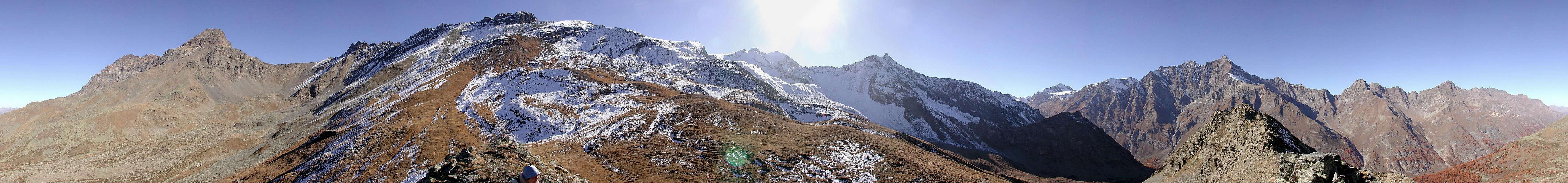
Testa di Entrelor is located in Rhêmes Valley, inside the Gran Paradiso National Park: looking at the head of the valley, towards south, it is on your left, just above the village of Rhêmes Notre Dames, between Sort and Entrelor hanging valleys (Valloni, in Italian). The summital ridge, directed towards the valley bottom, is firstly grassy, then becomes rocky. From its top you can see eastwards the watershed Val di Rhêmes-Valsavarenche: Punta Bianca di Bioula, la Roletta, the near (snowy) Punte Gollien, then the more distant Cima Percia, Cima di Entrelor, Aouillè and the sharp Becca Tsambeina. In front of it (westwards) all the watershed Val di Rhêmes-Valgrisenche: the highest summit is la Grande Rousse (3.607m). It is also a very interesting ski mountaineering course, as usually you find powder snow on the side of Vallone di Sort, firn on the side of Vallone di Entrelor.
Getting There and Route
You can arrive in Val di Rhêmes:
from France, through the Mont Blanc Tunnel or the Col du Petit Saint Bernard: you can drive on SS.26, following the direction for Aosta and, before arriving in Villeneuve, turn right towards Introd. Alternatively, you can take motorway A5 (at Courmayeur or Morgex) and exit at Aosta Ovest.
from all the other directions: get to the Aosta Ovest exit of motorway A5. Then drive along SS.26 Aosta, direction Courmayeur, and just after Villeneuve turn left towards Introd.
Shortly after Introd, you arrive at a junction: go straight following the sign "Val di Rhêmes" and then drive through Rhêmes Saint Georges as far as Bruil (1.723m), the main village of Rhêmes Notre Dames. Park the car in the small square of Rhêmes Notre Dames or in the near underground parking and look at your left for the yellow sign ENTRELOR. This mountain (Cima di Entrelor, 3.430m) is very famous:
in the first place, as one of the most known and beautiful sky mountaineering courses, 1.700 meters of pure descent along wide, fantastic slopes
in the second place, as a famous ski mountaineering race, for sky-runners.....
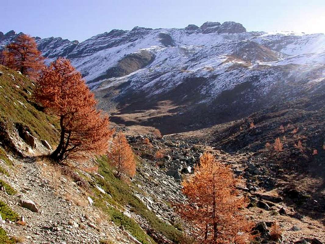
After the bridge, there are others yellow signs: follow the one of ALTA VIA n°2 that arrives in Valsavarenche through the Entrelor Pass (3.002m). Beyound a few huts, recently restored, you reach a junction: follow the lane on your left (number 9). In a beautiful wood of larches the path sometimes winds steeply and arrives, above the limit of the trees, at a hut of the park's rangers; here you find a nice place to seat and take a rest, fresh water and a map. A junction leads left to Chaussettaz, right to Testa di Entrelor (trail number 7); follow this sign, and enter in the narrower valley, where it is possible to see the typical wild animals of the park, the chamois and the bouquetin. The path follows the Vallone di Sort and after the ruines of Sort Alpage turns right, ascending steeply as far as a saddle connecting the Sort and Entrelor hanging valleys. From the saddle, in a while to the top of Testa di Entrelor, that is indicated by a small cross in wood. In front of you, on the other side of the valley (westwards), the imponent massif of Grande Rousse; behind you (eastwards), Col di Sort, Rolettaz, Gollien, and the Glacier of Entrelor with the tops of Cima di Entrelor and Aouillè. Return to the saddle, and follow descending towards the vallone di Entrelor; the path enters in the valley and crosses the slopes as far as the rests of the old typical buildings of Plan di Feye (2.403m), partially underground, characterized by a barrel vault. Here you meet again the path of the ALTA VIA n°2; follow descending at your right, till the edge of the enchanting Entrelor plain, delimited by a cross, leaving at your left the Alpages di Entrelor (2.142m). Follow the lane entering in the wood going down until the junction with the trail descending from Vallone di Sort, dominated from a rocky monolith named Chateau de Quoilette. After the junction descend along the same outward trail returning to the starting point.
When To Climb
The summit of Testa di Entrelor can be reached in every season: from the first snow to April with ski, from spring to fall on foot. The course is easy.
Campings
Testa di Entrelor is in the Gran Paradiso National Park, so there are some restriction: camping is not allowed, you can't take dogs with you in this course.
Meteo
You can get meteo information at the official site of the Regione Valle d'Aosta:
E. Andreis, R. Chabod, M.C. Santis "Guida dei Monti d'Italia - Gran Paradiso Parco Nazionale" Club Alpino Italiano / Touring Club Italiano, 1980 (in Italian)
L. Zavatta Le valli del Gran Paradiso e la Valgrisenche, guide dell'Escursionista, 2003 (in Italian)
MAPS
Kompass Gran Paradiso Valle d'Aosta Sentieri e rifugi-Carta turistica 1:50.000
IGC-Istituto Geografico Centrale Valsavarenche Val di Rhêmes Valgrisenche Carta dei sentieri e dei rifugi 1:25000
Photos by Sergio Enrico
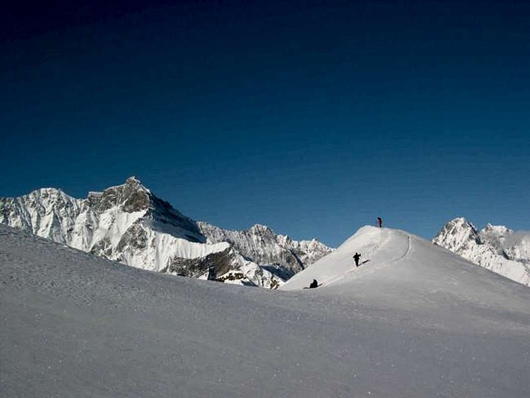
As I told before, Testa di Entrelor is also a very nice ski mountaneering course, where the snow is almost always good at least in one of the two sides. Thanks to Sergio for the winter shots!
Photos by Livioz
Miscellaneous Info
If you have information about this mountain that doesn't pertain to any of the other sections, please add it here.
Parents refers to a larger category under which an object falls. For example, theAconcagua mountain page has the 'Aconcagua Group' and the 'Seven Summits' asparents and is a parent itself to many routes, photos, and Trip Reports.


 8699 Hits
 89.39% Score
 29 Votes