
-
 7084 Hits
-
 88.82% Score
-
 28 Votes
|
|
Mountain/Rock |
|---|---|
|
|
44.69572°N / 7.07299°E |
|
|
Piemonte |
|
|
Hiking, Mountaineering, Trad Climbing, Sport Climbing, Scrambling, Via Ferrata |
|
|
Summer |
|
|
9915 ft / 3022 m |
|
|
Overview
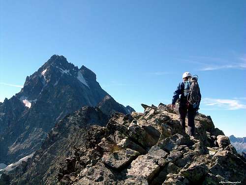
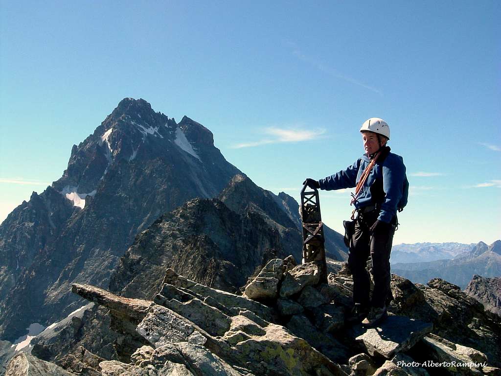
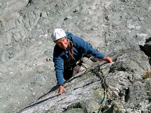
The arrival on the summit of Punta Udine
Punta Udine 3022 m
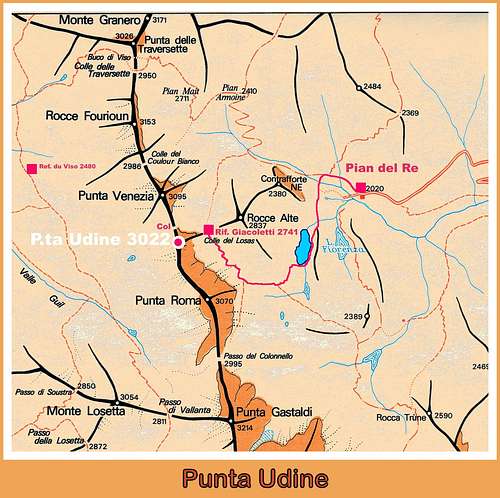
Punta Udine is a very interesting peak lying in Alpi Cozie Meridionali, rising to South-East of Colle del Couloir del Porco on the main boundary ridge between Italy and France, at the Northern end of the long ridge joining it with Punta Roma. It is one of the most climbed peak in Monte Viso Subgroup, because of its closeness to Giacoletti Hut, an easy normal route and moreover a satisfactory number of climbing routes on very good rock. Its interest is mainly concerning the steep East face, overlooking Giacoletti Hut, the North-East face and the ridges. The peak shows an intrusive igneous kind of rock, named “gabbro”, similar to the granite but more sculpted, which quality is excellent on the steep East Face and on the slabbing North-East face, both lying in the vicinity of Giacoletti Hut. The most impressive and high face of Punta Udine is its challenging East face, but also the routes on NE face are quite interesting.
First summiters: Giuseppe Morassutti with Giuseppe Perotti in 1899 along the North ridge
Getting There
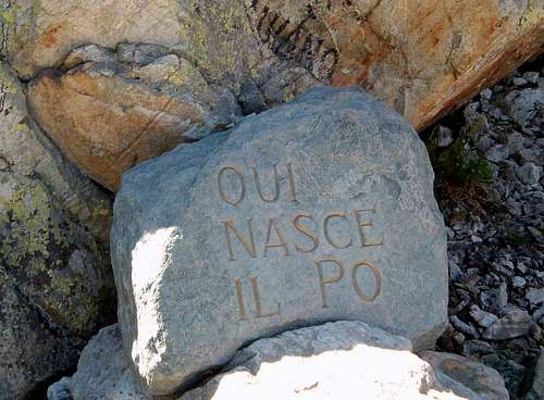
The source of the Po River on Pian del Re
ROAD ACCESS
From Turin or from Cuneo reach the town of Saluzzo m. 340; follow the Valle Po, crossing Sanfònt m. 490, Paesana m. 614, Oncino m. 1220 and Crissolo m. 1318. The last road hairpins lead to Pian del Re m. 2020, where the road ends (41 km. from Saluzzo).
WALKING APPROACH TO GIACOLETTI HUT
From Pian del Re m. 2020 follow the good path (marks GTA, V16) to Colle delle Traversette, rising towards NW and reaching the height of 2115 m. From here leave the main path and turn to left on another good path (marks V17) rising below Rocce Alte del Losas and leading to the fine lake named Lago Superiore m. 2313. The path skirts the east shore of the lake. At the junction with the path V14 continue along the path V17 getting to the Giacoletti Hut m. 2741 (2 hours from Pian del Re). Parking ticket: € 10
Punta Udine Normal route
From Pian del Re climb up to Rif. Giacoletti 2741 m. From the refuge we head westwards gaining, along the moraines, often snow covered until late season, the start of the Coulour del Porco, the obvious gully separating Punta Udine on the left from Punta Venezia on the right. With snow the ascent is made directly on the gully with slopes about 35° steep, while in summer conditions you climb up the route, equipped with numerous fixed ropes, placed on the right (orographic left of the gully). You will soon reach the col at 2920 m, from which both the normal ascent routes start: to Punta Udine (20 minutes) and to Punta Venezia (40 minutes).
All the climbing routes of Punta Udine
Most of the routes on the Eastern walls of Punta Udine are just at a few minutes from the refuge
All the routes of Punta Udine (the comprehensive engage is expressed in Alpine alphabetical scale, the single moves in French Scale)
NW Ridge (Normal route)
Difficulty: F
Length: 280 m.
Exposure: NW
First ascent: the first summiters
Easy scramble to reach the summit, steep in the upper part.
From Rifugio Giacoletti cross a scree towards North and rise towards the bottom of the gully. Climb the scree and rocky gully on Via ferrata (snow in the upper part even in late summer) getting to Couloir del Porco Col m. 2920. From the col an easy scramble on the left wide ridge leads to the summit.
***East Face
This face is lying just behind Giacoletti Hut ( few minutes by walking from the hut)
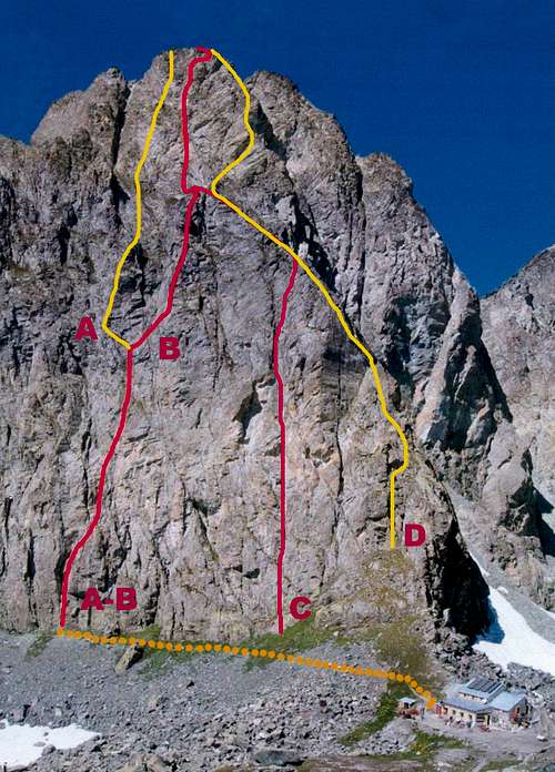
Punta Udine East face routes: A Turbo - B Visto per il Perù - C Risiko - D East Ridge
- Turbo
Difficulty: TD, 6a+ max, 5c obbl. (French scale)
Equipment: route equipped with bolts
Length: 320 m., 10 pitches
Exposure: E
First ascent: Massimo Piras – Paola Brezzo summer 1999
The first 4 pitches are the same of the route Visto per il Perù, then Turbo climbs an original line.
- Visto per il Perù
Difficulty: TD-, 6a max, 5c obbl. (French scale)
Equipment: route equipped with bolts
Length: 380 m., 12 pitches
Exposure: E
First ascent: Massimo Piras – Paola Brezzo 18-7-1998
The first route climbed on the great and complex East face of Punta Udine; rarely climbed till the year 2009, when the route had been entirely equipped, now it’s becoming one of the finest sportive routes of the area.
- Risiko
Difficulty: TD-, 6a max, 5c obbl. (French scale)
Equipment: route equipped with bolts
Length: 400 m., 15 pitches
Exposure: E
First ascent: Massimo Piras – Mauro Castellengo – Stefania Ruberi 20-9-1998
Another great sportive route
- East Ridge
Difficulty: AD+, 4c max, 4b obbl. (French scale)
Length: 400 m., 12 pitches
Exposure: E
First ascent: F. Burdino, D. Genero and E. Serafino 21-9-1952
This route is a great classic one “mountain style”; an interesting climb on homogeneous difficulty and good rock running quite on the East ridge lying within a stone’s throw from Giacoletti Hut.

|

|
***North East Face
- Diedro Raffi
Difficulty: TD, 6b max, 6a obbl.
Length: 200 m., 5 pitches to the junction with Tempi Moderni
Exposure: NE
First ascent: Francesco Raffi – Paolo Rattazzini july 1964
A beautiful classic climb running on the obvious corner on the left of Tempi Moderni.
- North-East ridge
Difficulty: D, V UIAA
Length: 400 m., 12 pitches
Exposure: E
First ascent: G. Bisotti – L. e F. Gentile 28-9-1969
- Tempi Moderni
Difficulty: D+, 5c max.
Length: 300 m., 7 pitches for Tempi Moderni, upper part along the NE ridge
Exposure: NE
First ascent: F. Michelin – B. and W. Canepa
Great route climbing fine and compact slabs, some overhanging moves.
- Alice 120-80
Difficulty: D+, 5c max.
Length: 320 m., 8 pitches on Alice, upper part along the NE ridge
Exposure: NE
First ascent: F. Michelin – B. and W. Canepa
Another great route on the right of Tempi Moderni.
- Udine Roma Ridge – Via Claudio Bocco
Difficulty: TD, 6a max, 5c obbl. (French scale)
Equipment: route equipped with bolts in the first 5 pitches, the further pitches are not equipped (4c max)
Length: 170 m., 5 pitches
Exposure: E
First ascent: F. Michelin – B. Canepa august 2004
This fine route climbs the first spur starting from the ridge joining Punta Udine to Punta Roma and coming down towards East. Approach from Giacoletti Hut in about 10 minutes. The route is entirely equipped with bolts. It’s possible rappelling from the fifth belay, otherwise it’s very satisfactory to climb the upper part of the spur – not equipped – getting to a notch along the ridge joining Punta Udine to the near Punta Roma, named “Cresta Roma”. Once getting to the “arête” there are two possibilities: towards right the ridge leads to the summit of Punta Udine, towards left - longer – to the summit of Punta Roma.
***Short sportive routes
On the steep pillar lying on the right of the classic East Ridge, 100 meters high, there are 3 shorter sportive routes on excellent rock.
- Lo spigolo
Difficulty: TD, 6b+ max, 6a obbl. (French scale)
Equipment: route equipped with bolts
Length: 90 m., 4 pitches
Exposure: E
- Sgùra la pelle
Difficulty: TD+, 7a max, 6a+ obbl. (French scale)
Equipment: route equipped with bolts
Length: 90 m., 4 pitches
Exposure: E
- La fessura
Difficulty: TD, 6a+ max, 6a obbl. (French scale)
Equipment: route equipped with bolts
Length: 90 m., 4 pitches
Exposure: E
Descent from Punta Udine: from the summit scramble down on the NW ridge (Normal route) to Colle del Couloir del Porco and Couloir del Porco leading to the hut
Hut
Rifugio Vitale Giacoletti 2741 m - C.A.I. Barge
Size: 55 beds
Open from 15-6 to 15-9
Phone +390175940104
Guardian: Andrea Sorbino
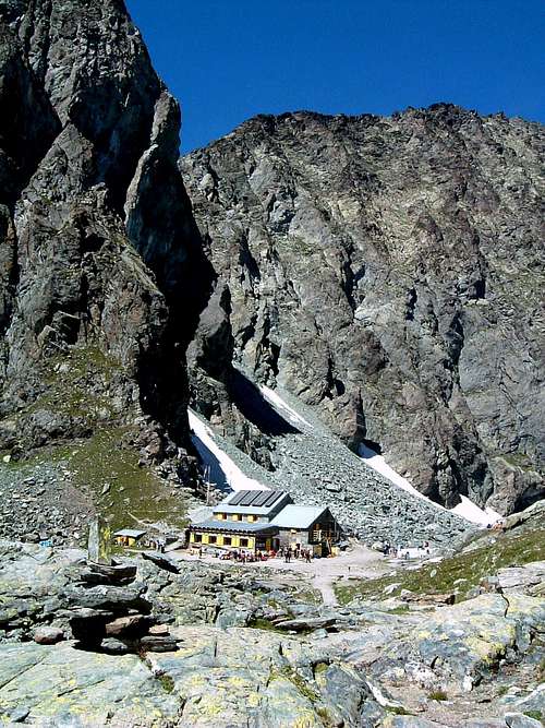
Giacoletti Hut
Red Tape
No particulary restrictions in hiking and climbing.
When to climb
Best season goes from the end of June to middle September.
Meteo
Meteo Regione Piemonte
Meteo Alpi
Guidebooks and Maps
 |
 |
 |
Guidebooks
“Monte Viso – Alpi Cozie Meridionali” by Michelangelo Bruno – Collana CAI-TCI Guide dei Monti d’Italia
“Pays du Viso – Escalade en Queyras entre France et Italie” by Sylvain Pusnel and Guillaume Vallot
Maps
"Monviso-Valle Varaita-Valle Po-Valle Pellice" - IGC sheet 106 1:25000