
-
 8007 Hits
-
 89.39% Score
-
 29 Votes
|
|
Mountain/Rock |
|---|---|
|
|
44.70663°N / 6.98830°E |
|
|
Queyras |
|
|
Mountaineering, Trad Climbing, Sport Climbing |
|
|
Summer |
|
|
10489 ft / 3197 m |
|
|
Overview
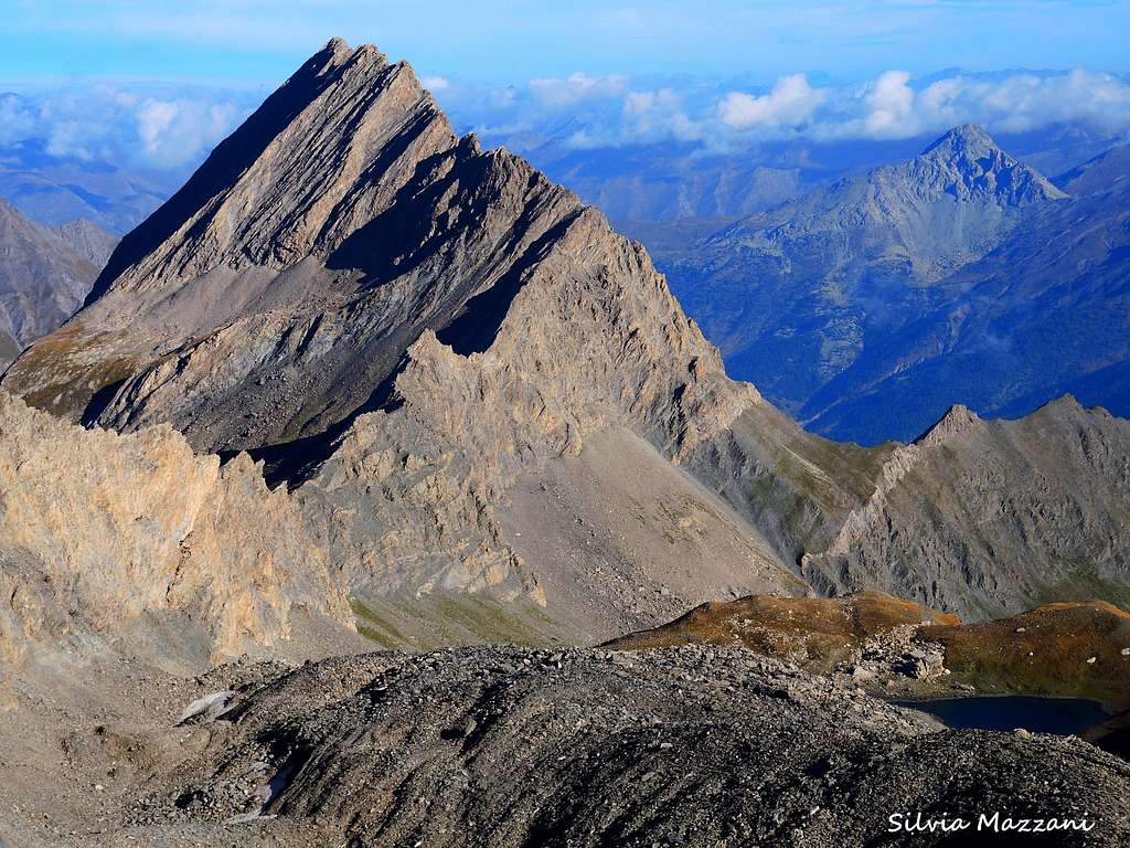
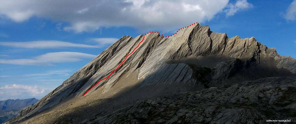
Crête de la Taillante 3197 m
Crête de la Taillante, or more simply Taillante, is an unusual shapes certainly attracting the gaze upon itself and belonging to Alpi Cozie Meridionali. Not by chance it was defined by W.A.B. Coolidge as "one of the strangest peaks of the Alps", in reason of its peculiar shape. It is located in the region of Queyras, North to Colle dell’Agnello, in the upper Valle del Guil, Ristolas municipality, and develops along a magnificent 4 km. long summit crest, sharp as a knife’s blade, and perpendicular to the main alpine divide, detaching from this one nearby Pan di Zucchero. This peculiarity explains and gives the name to the peak (in French “taillant” means “sharp”). Crête de la Taillante has three summits lined up on the long summit crest: the Northern one is the highest (m. 3197), the Central m. 3185 and the Southern is the lower (m. 3178).
Getting There
Road access The starting point to climb Taillante is a pull-out inside a hairpin on the road D205T between the Refuge Agnel m. 2580 and Col Agnel m. 2600.
- From France: from Guillestre follow the road D902 (Route du Queyras), at a fork take on the right the road D947 to Chateau en Queyras, then the road D205T to Molines en Queyras to the pull-out beyond the Rifugio Agnel. - From Italy: from Turin (Caselle international airport) take the A6 Torino-Savona Motorway, exit Saluzzo. Take the road to Valle Varaita, getting to Sampeyre, Casteldelfino, Pontechianale, Chianale and Colle dell’Agnello m. 2748 on the Italy-France border. Descent about 2 km. on the French side of the col as far as a road pull-out on the right at 2650 m., between the col and the Refuge Agnel.
Walking approach to Crête de la Taillante
From the pull-out on the road D205T between the Refuge Agnel and Col Agnel take the path GR58 to Col Vieux m. 2806, getting to the col after 30 min. Follow on the right a path descending in the wide valley towards the lake Forèant, then head to right towards the base of Taillante, following an uncertain path (some marks and cairns) getting to the starting point of the Normal route.
History
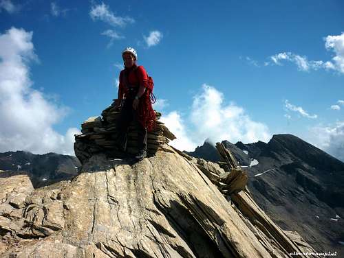
First summiters: Paul Guillemin and Hyacinthe Véeritier, 1876 september 7th
Taillante main routes
- West side Normal route F+ This route is a long scramble involving some short moves grading II UIAA
- North-South ridge traverse AD+ W.A.B. Coolidge with Christian Almer 1884, August 15th
- South-North ridge traverse D- E. Frendo – F. Woehrlè
Modern routes
- Science Friction D-, 5b, 5a obbl. 200 m. Five pitches route - The descent from this route is done traversing right (facing in) on a ledge to join the normal route
- Danse avec les loups (SW Face) D, 5c max (5b obbl.) 350 m. + 300 m. along the crest S. Pusnel and Cherbonnier 1999 - The great classic modern of the mountain, allowing a pleasant climb on solid rock and developing on 12 pitches and besides along a section of the summit ridge.
 short overhang")
|

|
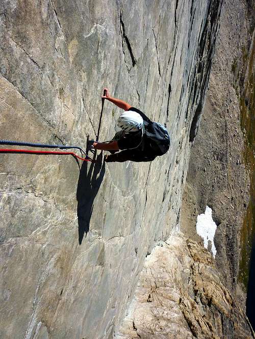
Danse avec les loups (Dance with the wolves) report
Danse avec les loups (Dance with the wolves) Summit altitude: m. 3197 Difficulty: D, French 5c (5b obbl.) Equipment: distanced fix, equipped belays Climbing length: 350 m. + 400 m. on the summit crest Exposure: SW First ascent: S. Pusnel and Cherbonnier 1999 Starting point: Road D205T between Rifugio Agnel and Col Agnel
The great modern classic of the SW face, a long "course" developing on 12 pitches along the slabs and besides, climbing a section of the summit ridge. The style is mainly technical on slabs sometimes smooth, anyhow the climb is always pleasant, on solid rock.
Danse avec les loups (Dance with the wolves) |
Danse avec les loups |
Danse avec les loups report - French scale
L1 Climb the wide and impressive smooth slabs following the open corner on the left of the slabs - 4a L2 Again up the corner - 4a L3 Start to leave the corner climbing slanting right on steeper rock - 4c L4 Traverse again rightward on level and with increasing difficulties - 5a

|
 upper sloping slabs")
|
L5 Last moves on the smooth slabs, then climb a short overhanging wall and head to right to the belay- 5c crux L6-L7 Climb a wide corner - 3b L8 Slab 4b L9-L10 Steeper slabs 4c L11-L12 the last two pitches on easier slabs led on the notch along the summit crest
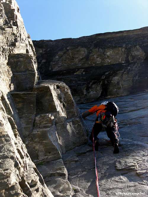
Normal route
West side Normal route
Difficulty: Scramble (some short moves grading II UIAA) Ascent’s length: 820 m. Total length: 1650 m. Total time: 6 hours
A peculiar ascent, staying between hiking and easy mountaineering. Taillante Normal route develops on tracks marked with rare cairns, following a system of ledges broken off by rocky walls, crossing the West face and incredibly allowing to climb easily the impressive 400 meters high slabs.

|

|

|
Red Tape
No particularly restriction in climbing and mountaineering. Taillante lies inside a Natural Reserve. Free camping is not allowed and fires are strictly forbidden. The whole fauna and flora are protected. Don’t disturb fauna and other mountaineering and hikers’ peacefulness with every kind of noise.

|

|
Where to stay
- Refuge Agnel Phone: 0033 4 92 45 83 90 Mobile: 0033 6 60 79 83 90

When to climb
Best season goes from the end of June to middle September
Meteo
Meteo Regione Piemonte
Meteo France
Guidebooks and maps
Guidebooks
 |
 |
“Escalade et alpinisme en Queyras – Pays du Viso entre France et Italie” by Sylvaine Pusnel and Guillaume Vallot – 2006
“Monte Viso – Alpi Cozie Meridionali” by Michelangelo Bruno - Collana Guide dei Monti d’Italia C.A.I. TCI
“3000 sans frontier – Alpes du Sud” by Bernard Ranc and Antoine Pirovano, 1997
Maps
IGN TOP 25 3637 OT Mont Viso