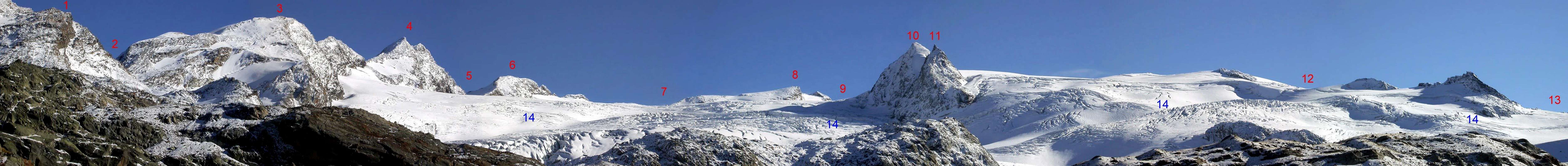
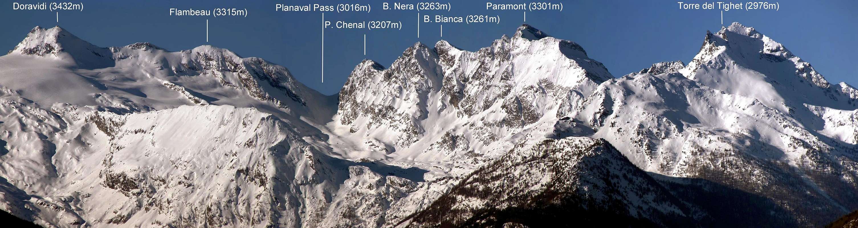
Last and regular pyramid, positioned on the long crest that from the topographical knot among the Becca du Lac (3.405m) and the Testa of the Rutor or Ruitor, (= Rutor's Head; 3.486m; between France and Valley of Aosta) it comes down to the small Group of the Mont Paramont, leaning out on the Central Valley of the Dora (= Stream) Baltea above the inhabited area of Derby Village and crossing the whole watershed between the Valleys of La Thuile/Valgrisenche. Before advanced to North, after the of Planaval Pass (3.016m), from the Becca Nera (3.262m), and from the twin one, also for almost equal height, Becca Bianca (3.261/2m) the both sited on the ridge that, with a last rise, it touches at first the Little Paramont or Quota about 3.230m~ to become exhausted themselves on the Peak of the Mont Paramont (3.301m), stings more elevated than the miniscule and attractive group to North of the great glaciers of the well more important GROUP of the Rutor. Toward North-northwest introduces to glacial slant of modest steepness and below to small rocky summital triangle, while in low he is bandaged by a characteristic rocky rib form of V. To South-southwest it goes down with a small wall divided by a gully of around 160/70 meters, while to East it allows to fall a face formed with rotten rocks of over 200m, incumbent on the Flambeau Glacier. Enough easy trip, not dangerous and even too much fatiguing, if completed in day with departure from the Albert Deffeyes Refuge (2.494m); intense excursion and of good person "endurance", if effected in day with beginning from the small center of La Joux (1.607m). Discreetly frequented in general, above all for the practice of the ski-mountaineering, but less popular than the ascent to the Becca Bianca and to more majestic Mont Paramont. Spacious sights toward South on the sea of ices among the Testa (= Head) of the Rutor, Becca of the Loch and the Great Assaly, while toward North the views are an a little limited by the most elevated and near pyramid of the Paramont, on which a fairly good but partial glimpse is had.
Ultima piramide, regolare, posizionata sulla lunga cresta che dal nodo topografico fra la Becca du Lac (3.405 m) e la Testa del Rutor o Ruitor, (3.486 m; tra Francia e Valle di Aosta) discende al piccolo Gruppo del Mont Paramont, affacciandosi sulla Valle Centrale della Dora Baltea, sopra l'abitato di Derby, e percorrente lo spartiacque intero fra le Valli di La Thuile/Valgrisenche. Seguitata a Settentrione, dopo il Passo di Planaval (3.016 m), dalla Becca Nera (3.262 m), e dalla gemella, anche per quasi pari altezza, Becca Bianca (3.261/2 m), entrambe posizionate sulla cresta che, con un ultimo rialzo, tocca dapprima il Piccolo Paramont o Quota 3.230 m~ per esaurirsi sulla Vetta del Mont Paramont (3.301 m), punto più elevato del minusculo e grazioso gruppo a Nord dei grandi ghiacciai del ben più importante GRUPPO del Rutor. Verso Nord-nordovest presenta un pendio glaciale di modesta ripidezza e sottostante ad un triangolino roccioso sommitale, mentre in basso è fasciata da una caratteristica nervatura rocciosa a forma di V. A Sud-sudovest scende con una piccola parete divisa da un canalone di circa 160/70 metri, mentre ad Oriente lascia cadere una parete di roccia rotta di oltre 200 metri, incombente sul Glacier du Flambeau. Gita abbastanza facile, non pericolosa e neppure troppo faticosa, se compiuta in giornata con partenza dal Rifugio Albert Deffeyes (2.492 m); escursione intensa e di buona "endurance", se effettuata in giornata con inizio dal piccolo centro di La Joux (1.607 m). In generale discretamente frequentata, soprattutto per la pratica dello sci-alpinismo, ma meno popolare dell'ascensione alla Becca Bianca ed al ben più maestoso Mont Paramont. Viste spaziose verso Mezzogiorno sul mare di ghiacci tra la Testa del Rutor, la Becca du Lac e la Grande Assaly, mentre verso Settentrione le vedute sono un poco limitate dalla più elevata e vicina piramide del Paramont, sul quale si ha uno discreto ma parziale colpo d'occhio.
First Ascents
First on the summit: Unknown.
First ascent in winter: Unknown.
N-NW Slope (Normal Route): Unknown.
S-SW Face: Emanuele Andreis and Eiiore Denina, (first days of August, 1926), in ascent.
NE Crest (to Becca Nera): Osvaldo Cardellina, lone, (Jul 09th, 1998), in descent.
Great Traverse from Baulin Village to Baulin: Mollette Pass - Mont Pit - Mont Paramont (through NE Ridge) - Little Paramont - Becca Bianca - Becca Nera - Chenal Point-Planaval's Pass: Osvaldo Cardellina, Ivo Chuc and Camillo Roberto Ferronato, (Jul 20th, 1996).
First Traverse from Planaval Pass - Chenal Point - Becca Nera - Becca Bianca - Invergneures's Points: Osvaldo Cardellina, lone, (Jul 09th, 1998).
Getting There
BY CAR:
From the Morgex exit of Motorway A5 (921m), continue for about 3 km on SS.26 towards Pré Saint Didier (1.017m). SS.26 becomes the main street of the small city and then continues toward Colle del Piccolo San Bernardo (2.188m). After several hairpins, and past the Villages of Elevaz (1.302m) and la Balme (1.309m) reach the famous ski resort of La Thuile (1.441m). Turn left on the bridge that crosses Dora di La Thuile in the direction of the Village of La Joux. After about 2 km from the bridge, having past a large square, cross another bridge on the Dora to the right. (From this point on, the road, although paved, is quite narrow. Proceed with caution.) After 1 km get to La Joux (1.607m) and park in one of the two parking lots, which are large but sometimes fill up in August. For this reason, access past the second bridge is limited at certain times. Be there before 9 AM to avoid problems, or take the shuttle bus to cover the last stretch.
IN AUTO:
Dall'uscita dell'Autostrada A5 nel Comune di Morgex (921 m) proseguire per circa 3 km lungo la SS.26 verso il Paese di Pré Saint Didier (1.017 m), addentrarsi nella via centrale del paese e proseguire sempre lungo la SS.26 che porta al Colle del Piccolo San Bernardo (2.188 m). Dopo numerosi tornanti e superate le Frazioni di Elevaz (1.302 m) e la Balme (1.309 m) si giunge alla famosa località sciistica di La Thuile (1.441 m), svoltare a destra sul ponte che attraversa la Dora di La Thuile e dirigersi verso la Frazione di La Joux (1.607 m). Dopo circa 2 km e superato un ampio piazzale, riattraversare sempre sulla destra un altro ponte sulla Dora (attenzione da questo punto la strada, seppur asfaltata, è molto stretta, procedere con cautela) e dopo circa 1 km. si giunge a La Joux (1.607 m), qui posteggiare l'auto in uno dei due ampi parcheggi a volte insufficienti nel mese di agosto. Per questo motivo relativamente al tratto dopo il secondo ponte c'è una limitazione oraria all'accesso dei mezzi privati, che comunque non tocca chi arriva prima delle 9. In alternativa esiste comunque una navetta bus.
BY PLANE:
Aeroporto "Corrado Gex"; Saint Christophe (Aosta).
Approach from La Thuile
First Day To begin the slope toward the Shelter Albert Deffeyes on the path in front of the "Cafe of the Falls" marked with the n° 3/High Route 15, after having gone beyond a bridge in wood on the left and later around 0h'15 you'll come to the First of the three spectacular Rutor Falls. Continue along the path and go beyond (on the left) the Parchet Alp (1.770m) set on the right (South), a first brooklet, the Plan Fruitier Alp (2.810m around) and another following small torrent, deriving respectively from the Preuvé Comba (= Basin) and from the Combassa.* Plan Fruitier Immediately detaches later him toward right (Or) a brief ramification towards the" Belvedere", near the quota 1.851m), under the Second and the Third Fall of the Rutor and above the Comba Sozin, deserving of visit through a small and easy digression from the street for the Albert Deffeyes Refuge (E; 0h'15). To always continue along the path what time it climbs him to terraces and, later around 0h'55 the Second Fall is gone beyond (signalled by a poster and not visible from the principal path). Later around as many 0h'15 the poster of the Third Fall meets him (1.996m); go up on the steep trail for other 0h'20, here the path divides him. To take that on the left (East-northeast) well signalled that it conducts to the Albert Deffeyes Hut, after having left (Northeast) immediately towards the entrance into Ussellettes Walloon.
** HIKING VARYING of TRIP in case of uncertain time or I win: that of right branch, numbered 8/High Route n° 2, door to the two magnificent Lakes of Bella Comba, the most greater of wich to quota 2.379m and the other as soon as under to quota 2.378m. The first one, positioned to Western, it is characteristic for a big boulder in his center to form of huddled up mouse (Besides see in SP Mont Charve; E; 2h'00/2h'15).
To actually go up again to the Collar (2.130m), for then to slightly go down on the right continuous and up to the Loch Glacier (2.143m); go beyond the bridge in wood that overhangs the emissary of the lake and, leaving on the right the homonym pastures (2.158m), to start over decidedly climbing along ample and wide hairpins bends up to reach the plateau run through first semicircular to of it (Northeast)and subsequently toward and-if (East-southeast), where site is the Shelter Albert Deffeyes (2.494m), not after having just abandoned first to the left (Northeast) the path n° 15/High Route n° 2 that is addressed towards the Ussellettes Valley. This is a good place to spend the night (2h'45/3h'00' from La Joux).
Primo Giorno
Iniziare la salita verso il Rifugio Albert Deffeyes sul sentiero davanti al "Bar delle Cascate", contrassegnato con il n° 3/15, dopo aver oltrepassato un ponte in legno sulla sinistra e dopo circa 0h'15 si incontra la Prima del tre spettacolari Cascate del Rutor; proseguire lungo il sentiero e oltrepassare (sulla sinistra) l'Alpeggio di Parchet posto sulla destra o S (1.770 m), un primo torrentello, l'Alpeggio di Plan Fruitier (2.810 m circa) ed un atro successivo piccolo torrente provenienti rispettivamente dalla Comba Preuvé e dalla Combassa. * Subito dopo Plan Fruitier si distacca verso destra (O) una breve diramazione adducente al "Belvedere", presso la quota 1.851 m, sotto la Seconda e la Terza Cascata del Rutor e sopra la Comba Sozin, meritevole di visita tramite una piccola nonché facile divagazione dalla via per il rifugio Albert Deffeyes (E; 0h'15).Continuare sempre lungo il sentiero che ora si inerpica a gradoni e, dopo circa 0h'55, si oltrepassa la Seconda Cascata (segnalata da un cartello e non visibile dal sentiero principale). Dopo circa altrettanti 0h'15 si incontra il cartello della Terza Cascata (1.996 m); continuare sul ripido sentiero per altri 0h'20; qui il sentiero si divide. Prendere quello sulla sinistra (E-NE) ben segnalato che conduce al Rifugio Albert Deffeyes, dopo aver lasciato subito a sinistra (NE) la Comba des Ussellettes.
** VARIANTE Escursionistica di GITA in caso di tempo incerto o cattivo: quello di destra recante il n° 8/Alta Via n° 2 porta ai due magnifici Laghi di Bella Comba, il maggiore dei quali a quota 2.379 m e l'altro appena sotto a quota 2.378 m; il primo, posizionato ad Occidente, é caratteristico per un gran roccione nel suo centro a forma di topo rannicchiato (Vedere inoltre in SP Mont Charve; E; 2h'00/2h'15).
Risalire sino al Colletto (2.130 m), per poi scendere leggermente sulla destra e proseguire fino al Lago Glacier (2.143 m); oltrepassare il ponticello in legno che sovrasta l'emissario del lago e, lasciando sulla destra l'omonimo alpeggio (2.158 m), riprendere a salire decisamente lungo ampi tornanti fino a raggiungere l'altipiano tramite un percorso semicircolare prima a NE e successsivamente verso E-SE, dove è sito il Rifugio Albert Deffeyes (2.494 m), non dopo aver abbandonato appena prima a sinistra (NE) il sentiero n° 15/Alta Via n° 2, indirizzantesi al Vallone des Ussellettes . Qui giunti, conviene pernottare (2h'45/3h'00 da La Joux).
Route
Second day
From the Albert Deffeyes Refuge to descend for about 50 meters the trail for the inlet stream of Lago Azzurro. Cross the small wooden bridge and keep the right trail n° 16, that leads to the Upper Rutor Lakes (2.539m). After about 10 minutes the trail forks. Keep left and reach shorlty after a small lake known by the names of "Dans la Roche" or "Lac Sans Nom" (2.602m). Continuous up to small with the at approximately 2.680m and on to the left moraine of the huge Rutor Glacier, To abandon this route few over the Spur South-southwest, that goes down from the Pointe des Invergneures (3.019m), to progressively address him in the small walloon understood by the long crest, that gathers this to Becca Bianca to North, from Becca Nera to East and from the Point Chenal to South. To climb for rocks "muttoned" and smoothed by the ices and to reach the small lake 2.826m; from this, always with direction of slope toward East, to reach around 2.950 meters around what he remains of the Glacier of Invergneures. Proceeding more Southeast to reach the rocky rib to form of V and easily to overcome it, or to immediately revolve the same on the right (West). To continue along the snowy slope impending and to go up again it with modest inclination (less than 30°) and to go himself at the base of the small summital tower, to form of rocky triangle; to directly overcome it in the mean, or to divert to the right on the Northwest Ridge, concluding in both cases easily and in little time in Peak. (1h'45/2h'00 from the Shelter Deffeyes; 5h'00/5h'30 from the Village of La Joux).
COMING DOWN: is along the same route.
Secondo Giorno
Ridiscendere per circa 50 metri il sentiero che porta all'immissario del Lago Azzurro; attraversare il ponticello in legno e portarsi sul sentiero di destra n° 16, adducente ai Laghi Superiori del Rutor (2.539 m). Dividendosi dopo circa 0h'10 il sentiero, continuare su quello si sinistra. Poco costeggiare un laghetto conosciuto come Dans la Roche o "Lac Sans Nom" (2.602 m). Salire insino al piccolo colle posto a circa (2.680 m); proseguire sul sentiero fino a raggiungere la morena sinistra dell'enorme Ghiacciaio del Rutor; abbandonanare questa via poco oltre lo Sperone Sud-sudovest, discendente dalla Pointe des Invergneures (3.019 m), per indirizzarsi progressivamente nel valloncello rappreso dalla lunga cresta, che riunisce questa alla Becca Bianca a Settentrione, dalla Becca Nera ad Oriente e dalla Punta Chenal a Meridione. Salire per rocce montonate e levigate dai ghiacci e raggiungere il laghetto 2.826 m; da questi, sempre con direzione di salita verso Oriente, raggiungere sui 2.950 metri circa ciò che rimane del Glacier des Invergneures. Procedendo più a Sudest raggiungere la costola rocciosa a forma di V e facilmente superarla, oppure aggirarla immediatamente sulla destra (Ovest). Continuare lungo il pendio nevoso soprastante e risalirlo con modesta pendenza (meno di 30°) portandosi alla base della torretta sommitale, a forma di triangolo roccioso; superarla direttamente nel mezzo, oppure deviare a destra sulla Cresta Nordovest, concludendo in entrambi i casi facilmente ed in poco tempo in Vetta. (1h'45/2h'00 dal rifugio; 5h'00/5h'30 dal Villaggio di La Joux).
DISCESA: per la stessa via di salita.
Difficulty
This route can be considered from F+ to PD-, according to the conditions of the slant snowy.
L'itinerario è classificato EE/A; da F+ a PD-, a seconda delle condizioni del pendio innevato.
Equipment
Ice axe, crampons and rope.
Piccozza, ramponi e corda.
Campings
Remember that free camping is forbidden (except for emergency reasons, over 2.500m, from darkness until dawn).
"Guida delle Alpi Occidentali", di Giovanni Bobba e Luigi Vaccarone C.A.I. Sezione di Torino Volume II (parte II), 25 Maggio 1896.
"Rifugi e bivacchi in Valle d'Aosta", di Cosimo Zappelli aggiornata da Pietro Giglio, Musumeci Editore.
"I Rifugi della Valle d'Aosta" di Stefano Ardito, Ed. Guide iter, Febbraio 2003.
"Guida dei Monti d'Italia–Alpi Graie Centrali" di Alessandro Giorgetta - Club Alpino Italiano/Touring Club Italiano, 1985 (in Italian).
"80 itinerari di Escursionismo Alpinismo e Sci Alpinismo in Valle d'Aosta", di Osvaldo Cardellina, Ed. Musumeci, Giugno 1977 (in Italian); seconda Ed. Luglio 1981; terza Ed. Luglio 1984; (in French), prima Ed. Febbraio 1978; seconda Ed. Marzo 1980.
"Diari Alpinistici" di Osvaldo Cardellina e Indice Generale accompagnato da Schedario Relazioni Ascensioni 1964-2019 (inediti).
MAPS:
Kompass "Gran Paradiso Valle d'Aosta Sentieri e Rifugi", Carta turistica 1:50.000.
L'Escursionista "La Thuile-Piccolo San Bernardo", (carta n° 2) 1:25.000.
A.I.A.T. La Thuile, "La Thuile Pianta dei Sentieri", 2004 (Plastico).
Carta Comunità Montana "Valdigne e Mont Blanc Les Sentiers", 2001 1:50.000.
I.G.C. Istituto Geografico Centrale "Il Parco Nazionale del Gran Paradiso", 1:50.000.
I.G.C. Istituto Geografico Centrale Torino "Monte Bianco-Courmayeur-Chamonix M.B.-La Thuile", (carta n° 107), 1:25.000.
Studio F.M.B. "Monte Bianco-Mont Blanc", Bologna 1988 1:50.000.
Parents refers to a larger category under which an object falls. For example, theAconcagua mountain page has the 'Aconcagua Group' and the 'Seven Summits' asparents and is a parent itself to many routes, photos, and Trip Reports.

 8142 Hits
 86.61% Score
 23 Votes


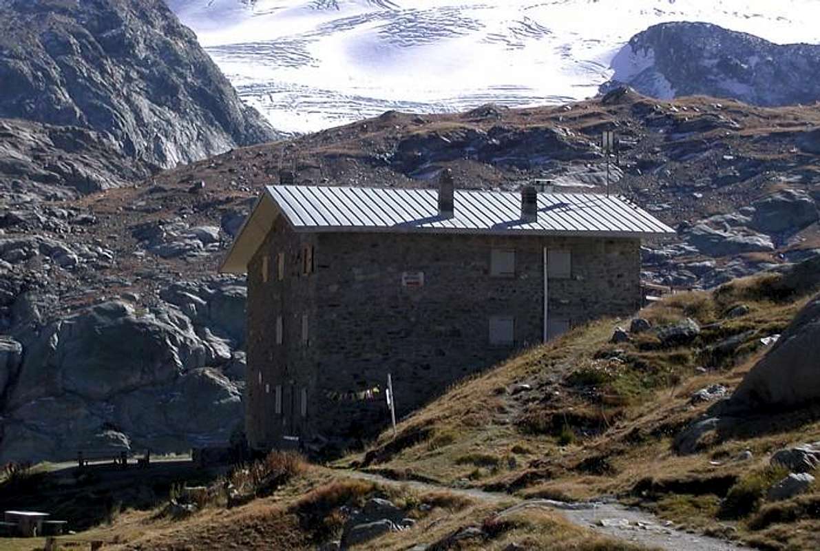 Rifugio Albert Deffeyes


