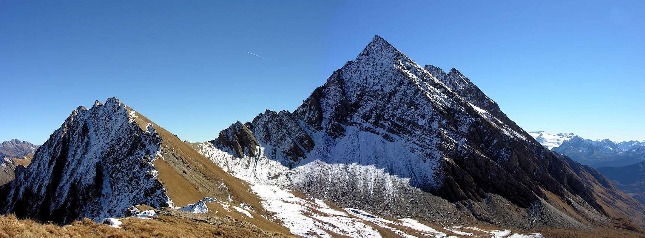
Characteristic pyramidal mountain with 3 summits, it grows up NW of the Miage Lake (2.020m - Val Veny), East of the Colle des Charmonts (2.787m), South of the Monte Berio Blanc (3.252m) and W of the Pointes des Chavannes (2.808m) and Mont Fortin (2.758m). From its summits a wonderful panorama over the Aiguille des Glaciers, (3.816m), the Aiguilles de Trélatête (3.940m) and Monte Bianco (4.811m).
Caratteristica vetta piramidale a tre punte sovrastante a nord ovest il Lago del Miage (2.020 m), a est il Colle des Charmonts (2.787 m) a sud il Monte Berio Blanc (3.252 m) e a ovest la Pointes des Chavannes (2.808 m) ed il Mont Fortin (2.758 m). Dalla sua sommità si gode un formidabile panorama sull'Aiguille des Glaciers, (3.816 m), sull'Aiguilles de Trélatête (3.940 m) e sul Monte Bianco (4.811 m).
First Ascents
First on the summit (from Colle du Berio Blanc): L. Mussillon and A. Pelloux, (Sep 22th, 1892).
N-NE Wall: Osvaldo Cardellina, Marco Cossard, Giuseppe Lamazzi and Gianpaolo Tripodi, (Jul 12th, 1987).
E-NE Arête: Osvaldo Cardellina, Marco Cossard, Giuseppe Lamazzi and Gianpaolo Tripodi, (Jul 12th, 1987).
Getting There
BY CAR:
From the Morgex exit of Motorway A5 (921m), continue for about 3 km on SS.26 towards Pré Saint Didier (1.017m). SS.26 becomes the main street of the small city and then continues toward Colle del Piccolo San Bernardo (2.188m). After several hairpins, and past the Villages of Elevaz (1.302m) and la Balme (1.309m) reach the famous ski resort of La Thuile (1.441m). Turn left on the bridge that crosses "Dora di La Thuile", a go on along the same road till the bridge before the Village of Pont Serrand, turn to the right following for Orgère (1.740m), where you must leave the car.
Dall'uscita dell'Autostrada A5 nel comune di Morgex (921 m) proseguire per circa 3 km lungo la SS.26 verso il Paese di Pré Saint Didier (1.017 m), addentrarsi nella via centrale del paese e proseguire sempre lungo la SS.26 che porta al Colle del Piccolo San Bernardo (2.188 m). Dopo numerosi tornanti e superate le Frazioni di Elevaz (1.302 m) e la Balme (1.309 m) si giunge alla famosa località sciistica di La Thuile (1.441 m). Svoltare a destra sul ponte che attraversa la "Dora di La Thuile", continuare a salire lungo la Strada Statale n°26 che conduce al Colle de Piccolo San Bernardo e giunti nei pressi del ponte che precede il Villaggio di Pont Serrand, voltare sulla destra seguendo la strada per Orgère (1.740 m), dove è posto il cartello di divieto di transito ai mezzi non autorizzati.
BY PLANE:
Aeroporto "Corrado Gex" Saint Christophe (Aosta).
Route
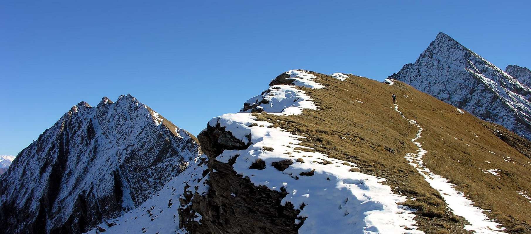
Walk up along the dirt road along the Vallone di Chavannes, after passing the mountain Pastures Chavannes di Sotto (2.128m), Chavannes di Mezzo (2.183m) and Chavannes di Sopra (2.421m); go straight toward NE to get the Col du Baracon (2.421m). Herefrom go along the wide ridge crossing the Mont Fortin (2.758m) and the Punte di Chavannes (2.811m). Following the ridge the path goes slightly down to the quota 2.728. On, zigzagging along the West ridge then cross to the right along the South side to get the Colle di Berio Blanc (2.824m). On along the steep grassy and debris slope to get the higher (Western) Summit (2.967m), and following the ridge get the Central Point (2.962m) and the Norther Summit (2.958m) (some exposed and tricky passages on bad quality rock).
Proseguire a piedi sulla strada in terra battuta il lungo Vallone di Chavannes, dopo aver superato gli omonimi Alpeggi: Chavannes di Sotto (2.128 m), Chavannes di Mezzo (2.183 m) e Chavannes di Sopra (2.421 m); puntare decisamente verso nord est sino a raggiungere il Col du Baracon (2.714 m). Da questo punto continuare sul largo crestone e oltrepassare il Mont Fortin (2.758 m) e subito dopo le Punte di Chavannes (2.811 m); sempre su cresta il sentiero scende leggermente sino a raggiungere quota 2.729 m. Proseguire con qualche zig zag lungo la cresta Ovest per poi iniziare a traversare verso destra lungo il versante Sud, sino a raggiungere il Colle di Berio Blanc (2.824 m); da qui salire il ripido pendio tra sfasciumi e zone d'erba sino a raggiungere la più elevata Punta Ovest (2.967 m). Da questa, tenendosi sul filo della cresta, si raggiunge la Punta Centrale (2.962 m) e di seguito la Punta Nord (2.958 m), con alcuni passaggi delicati ed esposti su rocce abbastanza instabili.
Equipment
Normal hiking equipment.
Campings
Remember that free camping is forbidden (except for emergency reasons, over 2.500m, from darkness until dawn).
Mountain Condition
You can get meteo information at the official site of the Regione Valle d'Aosta:
Parents refers to a larger category under which an object falls. For example, theAconcagua mountain page has the 'Aconcagua Group' and the 'Seven Summits' asparents and is a parent itself to many routes, photos, and Trip Reports.

 9187 Hits
 90.13% Score
 31 Votes