
|
|
Mountain/Rock |
|---|---|
|
|
19.50880°N / 97.4373°W |
|
|
Tepeyahualco |
|
|
Hiking |
|
|
10105 ft / 3080 m |
|
|
Overview
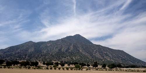
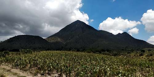
Cerro Pizarro is one of the most iconic landmarks in the Oriental Basin, a semiarid endorheic valley in the state of Puebla in south-central Mexico. Its summit lies at an altitude of around 3095 meters above sea level (listed as 3080 m, as the geographic agency of Mexico only defines official contour lines in 20 m sequence for most of the national territory), which is rather discrete compared to the colossal 4- and 5000er volcanoes that get most of the airtime in Mexico. Still, Cerro Pizarro's steep slopes, that rise out of seemingly nowhere from its flatter-than-flat base, give the mountain an isolated, distinctive, almost stereotypic triangularity, and make up for somewhat demanding ascents in the context of a half-day hike.
Like Las Derrumbadas and other nearby mountains, Cerro Pizarro is a rhyolitic volcano. It formed over a 150 ka period, its final eruptive event occurring some 65 ka ago. This contrasts with "normal" rhyolitic domes, that are usually the result of a single eruptive event, so Cerro Pizarro is actually considered a complex volcano with some characteristics of a stratovolcano. It is allegedly named for conquistador Francisco Pizarro, while also referred to as "Peak of Tepiacualca" by some authors (Tepiacualca being a former name for Tepeyahualco, which is the municipality the mountain lies in).
Getting There
Cerro Pizarro is within reach of two towns that lie north and southwest of the dome: Guadalupe Sarabia and San Nicolás Pizarro, respectively. If you choose the northern trail, you can take federal highway 140D, take a "Mexican exit" at 19°31'26.4"N 97°25'06.4"W, and drive near the base, leaving you car at the trailhead of the Wikiloc page I link below. I personally found the southeast route more enjoyable, though, as the path is clearer and you won't have the sun in your face as you climb. In this case, you can start in San Nicolás, or else at a tiny mine adyacent to the northbound road, exactly at 19°29'52.3"N 97°27'18.4"W. Either route is about 3 km to the top, with an elevation gain of 600 to 700 meters. If you aren't car-bound and feel like doing the complete cross-mountain trail, I'd advise you to hike north to southeast: Transportation is better to Guadalupe Sarabia and from San Nicolás.
Route
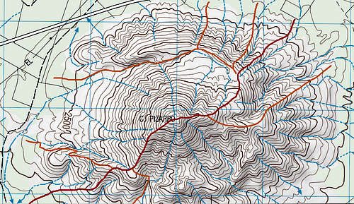
The routes are pretty straightforward, as the paths are more or less clearly marked. One thing you should consider, though, is the mountain's topography. It consists of a mostly symmetric cone in the center, encompassed by the horseshoe-shaped remains of an earlier dome, surrounding the summit clockwise from northwest to southwest. This means that the peak is bordered by inner gullies, and can only be reached via the arêtes. The map pictured below (cropped from the INEGI map "E14B25: Xonacatlán", see external links) shows the two standard routes to the top (in red), as well as alternative routes (in orange) that I have either seen posted online, or inferred by exploring satellite images of the mountain. Nevertheless, I would strongly encourage you to stick to the standard routes and especially to stay away from the gullies, as they are very rocky and extremely steep (with quite a few cliffs, too), which is not a safe combo.
Either of both standard routes should take you to the top in about 2 hours. During the climb, be sure to take a few moments to look at the surroundings below. Cerro Pizarro's location allows for nice panoramic views of lake El Salado, Los Humeros volcanic flow, and the tall mountains located to the east and south. On a clear day, you should also be able to spot some of the valley's characteristic maars.
Camping & Other Activities
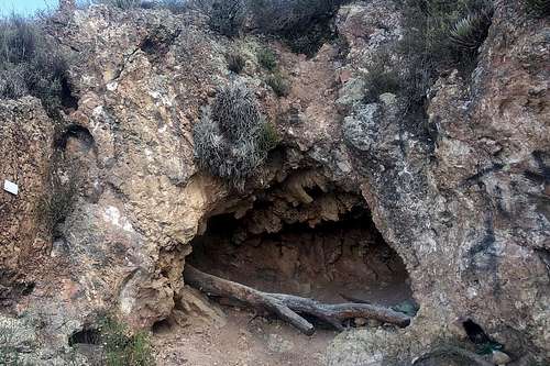
South of the summit, at around 2840 m a.s.l., there are two or three caves where some climbers seem to stay for the night. I don't know how enjoyable of an experience that is, but feel free to try it if that's your deal.
Cerro Pizarro is only about half an hour from Cantona, one of the region's main archaeological sites. If you get back down around noon and haven't had enough for the day, a visit is definitely worth it. You could also head the other way and visit lake Alchichica, an interesting crater lake at the border of the states of Puebla and Veracruz.
When to Climb
The mountain is safe to climb year round. In the rainy season (roughly June to September), be sure to check the weather. Although central Mexico is noted for its afternoon storms, it usually starts earlier in the Oriental Basin, and day-long drizzles are no rarity. Also, consider that the valley attracts fog during the morning: If you start too early, you probably won't have a clear view from the top.
Flora and Fauna
Cerro Pizarro holds a xeric shrubland typical of the drier parts of Mexico, including most of the Oriental Basin. The gullies are wetter and thus able to sustain forest strips, which consist mostly of pinyons and oaks. The upper parts are covered in an oak-manzanita shrubland sprinkled with a few hard pines. You will typically find plants that are adapted to long dry seasons, such as cheilanthoid ferns as well as members of the asparagus, daisy, stonecrop, legume, heath, and cactus families. Pincushion cacti are particularly abundant, you will see tons of Mammillaria haageana, M. discolor, and M. magnimamma.
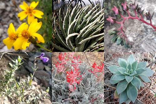
The Oriental Basin is home to many endemic plant species, and Cerro Pizarro is no exception. Some species you should look for are: Tagetes linifolia (Asteraceae), Hechtia perotensis (Bromeliaceae), Echeveria heterosepala, Echeveria subalpina (both Crassulaceae), Astragalus helleri (Fabaceae), and Salvia thymoides (Lamiaceae). These species are pictured below, clockwise from top left.
The animal diversity is less exciting, as the rocky terrain is unable to hold moisture for too long. You will see many spiny lizards (Sceloporus spp.), a few scrub jays (Aphelocoma woodhousei) and spotted towhees (Pipilo maculatus), some butterflies and moths, maybe a rabbit (Sylvilagus floridanus) if you're lucky. Yeah, not that great. Focus on the flora instead. ;)
External Links
- Cerro Pizarro on Wikipedia (Spanish)
- E14B25: Xonacatlán (INEGI map; Cerro Pizarro shown at the bottom center)
- Southwest route on Wikiloc
- North route on Wikiloc
(Don't mind the hysterical elevation profile on the third link. My phone's GPS sucks, lol.)