
|
|
Mountain/Rock |
|---|---|
|
|
19.04000°N / 99.26°W |
|
|
13077 ft / 3986 m |
|
|
Overview
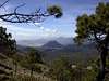
Ajusco (also known as Malacatepetl), is an extinct 52 million year old volcano that holds the distinction of being the most frequently climbed peak in all of Mexico... because it is located in the south of the D.F. and droves of Mexicans flock to its slopes on holidays and on weekends to escape the press of the most populated city on earth.
On your climb it is possible that you will encounter all manner of people from young children to men and women in their seventies in a pair of beat up sandals going for a stroll. The volcanos occupy a central part in the lives and the history of Mexico and because of this they draw all types of people, climber and non climber alike. I would suggest the best time to climb Ajusco would be early on a weekday morning so one could enjoy the peak with a degree of tranquility. Ajusco which means ‘eagle’s beak’ has two distinctive summits. El Pico de Aguila is the smaller of the two at 3930m while La Cruz de Marquesa is the high point at 3986m, its summit is marked by a large bronze cross. Ajusco has no distinctive crater as much like Telapon it collapsed millions of years ago during an exceptionally violent eruption.
Ajusco is located in the 2300 Ha Parque Nacional de San Nicolas in a 900 Ha subsection of it called Parque Nacional Cumbres del Ajusco. Ajusco is the gateway out of the valley of Mexico and onward to places like Cuernavaca, Toluca and Taxco. It is also known as the lung of the valley or the ‘green mountain’ as the air tends to be considerably cleaner here. It is fairly easy to reach both summits in half a day though it might require another hour to an hour and a half added to your overall stay on the mountain.
The view from the summit is excellent, provided of course it is during the dry season and it is in the morning before the smog sets in. One can ask for no better vantage point to look out over the entirety of the valley. On clear days you can see Izta and Popo, Tlaloc and Telapon to the NW and on exceptionally clear days I've heard you can make out Nevado de Toluca to the west. The Park is home to maguey, wild roses, rare owls and rabbits and a plethora of other plants and animals. Ajusco’s slopes are dotted with scrub oak and pine forests, and the summit was sacred to the Aztec’s as it was used as a place of worship. Like most of the major volcanoes surrounding Mexico City Ajusco had a role in the daily lives of the Aztecs. Traces of an Aztec presence have been found on Ajusco that date back to the 12th and 13th century.
 |
 |
 |
 |
 |
Getting There
To get to Ajusco from Mexico City you must take the Pereferico towards Toluca (in most cases this will mean heading south) and don’t be discouraged by the traffic of how long it seems to be taking, the Pereferico runs around the perimeter of Mexico and is thus justifiably huge. From the Pereferico turn towards the ‘carretera Picahco Ajusco’ on Canal 13. On the way you will pass six flags, and the highway will be reduced to one lane. From here you have 2 choices when the road comes to a ‘Y’ intersection. You can follow the road 24km towards Toluca and you can enter into the park via the back of Ajusco or you can take the turn which leads to Ajusco.
It is highly probable that you could get lost... even those who have lived in the city their entire lives frequently get lost, just ask for directions to the park or if you are close enough you will be right near UNAM (Universidad Nacional Autonoma de Mexico) otherwise known as university city. It has an enrolment of 300 000 and if it isn’t the largest university on earth it must be damn close. The engineering faculty alone has as many people as students from my university. From UNAM you can easily make your way, as from my experience the people of Mexico are more than willing to help.
There is a paved road around Ajusco and a choice of three trails. You can head up the southern side routes which are supposedly the easiest routes or you can take the ‘Lodge Route’ which heads up the NW ridge of the blown out crater. It is a slightly more difficult ascent, but all routes steepen as you clear the tree line and make your way up the rocky slopes. Like many of the Mexican volcanoes Ajusco is heavily weathered and there is a lot of loose rock dotting her slopes. On the north side of Ajusco there are several places where one can rock climb with climbs ranging from 5.6 to 5.11b.
All routes are walk ups and are CLEARLY marked. You gain around 1100-1200 metes (3650-4000ft) on the ascent and it should take no more than 2-4 hours (depending on one's level of fitness) roundtrip to complete.
 |
 |
 |
 |
 |
Red Tape
There is no red tape. Unlike Popo, Izta, Orizaba or Nevado de Toluca there is little in the way of cost that is incurred in getting to this mountain. While it is located in a National Park there are no set fees to pay (and even if there was it would probably be only a few pesos). like there is when you head up Nevado de Toluca or enter Izta-Popo park.
When To Climb
The best time to climb Ajusco is from November to March (during the dry season)… though having lived in Mexico for a year there are opportunities to climb this peak year round as it only takes half a day. Oftentimes even in the rainy season you can find a clear morning to head up Ajusco... its just that the earlier you start the better your chances are to avoid inclement weather.
 |
Camping
There is no camping allowed in the park though Mexicans as a whole tend to be very relaxed about rules like this and if you were to pick a sheltered spot out of the way I am quite sure that you would encounter little in the way of difficulties. There are no fees that I know of at this time, but even if there was it would probably amount to no more than a few pesos. One can spend the night at the refugio hut however... be prepared like all huts in Mexico it is VERY rustic. There are also food vendors all around if one wants to sample some authentic Mexican cuisine.. just be wary of vegetables they are what usually give people the dreaded 'revenge'.
Mountain Conditions
There are no mountain cams, but the weather can easily be checked as Ajusco is found within the confines of Mexico City... so one need only check the weather for the city and be sure to follow the rule that it is usually clear in the morning and clouds over as the day progresses, you should be good to go. You can check www.mapsofmexico.com/mexico/weather for accurate up to the minute details of the weather in the D.F.
Dalesmicro - Oct 31, 2005 12:27 am - Hasn't voted
Untitled CommentI believe that the correct coordinates for Ajusco are:
19 degrees 12 minutes 46 seconds N
99 degrees 15 minutes 22 seconds W
I hope that this information is heplful
Sincerly, Dale
Mark Kness - Jul 19, 2006 7:13 pm - Hasn't voted
Re: Untitled CommentDale - Those seem to be the coordinates for Pico del Aguila, a lower subpeak of Cerro Ajusco. The coordinates that I measured by GPS are: Cerro La Cruz del Marqúes - N19 12 27.2 W99 15 29.4 - 12898 ft (3931 m) - The actual highpoint Pico del Águila - N19 12 46.8 W99 15 25.2 - 12776 ft (3894 m)
btaban - Feb 8, 2015 11:06 am - Hasn't voted
Finding the trailheadI actually had a really hard time finding the trailhead. I wish I had the coordinates to save you the trouble, but I don't. Wrote a blogpost on this: http://blog.tabanpour.info/personal/2015/01/27/sf_mexico_trip.html
gregorydickson - Dec 4, 2017 7:21 pm - Hasn't voted
Rope BridgeHere is a google maps link to the rope bridge mentioned in btaban's blog post: https://www.google.com/maps/place/Hostel+Alpino+Ajusco/@19.2261919,-99.2680079,3a,75y,90t/data=!3m8!1e2!3m6!1sAF1QipMj-jTLTofWiEtdYkErYQK5DoxKO7v1XJl9jW7J!2e10!3e12!6shttps:%2F%2Flh5.googleusercontent.com%2Fp%2FAF1QipMj-jTLTofWiEtdYkErYQK5DoxKO7v1XJl9jW7J%3Dw203-h114-k-no!7i5344!8i3006!4m12!1m6!3m5!1s0x0:0x49f99ecd4e57c3eb!2sCaba%C3%B1a+%22El+Buen+Gusto%22!8m2!3d19.2290886!4d-99.2670653!3m4!1s0x85cdfc0ff8594ad9:0x1f1cab3f539a1ea4!8m2!3d19.2261912!4d-99.2680085?hl=en