
|
|
Mountain/Rock |
|---|---|
|
|
19.15818°N / 97.91923°W |
|
|
Acajete |
|
|
Hiking |
|
|
9580 ft / 2920 m |
|
|
Overview
El Tintero (Spanish for 'the inkwell') is located between the towns of Santa Isabel Tepetzala and El Rincón Citlaltepec, in the state of Puebla in South-Central Mexico. Overshadowed by its bigger and densely forested twin El Pinal (3,280 m), El Tintero offers a modest hike, simplified by the presence of a cobblestoned trail. Sadly, the view of the nearby La Malinche volcano (4,420 m) from the summit is blocked by the presence of microwave antennas; but El Tintero still makes a nice day trip from Puebla or Huamantla, even for unskilled hikers.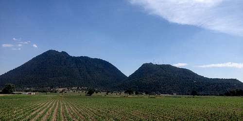
El Pinal (left) and El Tintero (right) from the north
Getting There
Take the Mexican Highway 129 (Amozoc-Teziutlán-Nautla). At the 20 km mark, some 1.5 km southwest of the El Rincón/Huamantla junction and very close to a gas station, a dirt road leads towards the mountain. You can park directly by the highway or drive uphill, leaving your car at one of the numerous switchbacks. In any case, I would advise you to leave a visible note inside the car, something like "Subimos al cerro" stating date and time, as some locals in rural Mexico will report unknown and perceivedly abandoned vehicles to the police.Intercity buses departing from Puebla CAPU (bus terminal) can leave you near the junction, from where you'd have to walk to the trailhead. I have no idea how much they cost or how long they take, but I'll update this info if I find out someday. :)
Route
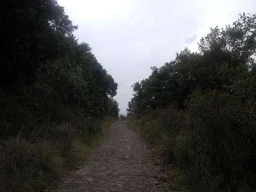
Cobblestoned trail
The trail crosses a couple of fields and later a dense oak forest which is home to the native fauna: cottontails rabbits among other rodents, various types of spiny and alligator lizards, singing birds etc. After about 3.5 km, you will reach a mostly straight and somewhat flatter area where a number of microwave antennas are located. From here, the summit is reachable via a small passage between two of the antennas. The last meters to reach the summit involve an easy scramble through the steep forest and volcanic rocks.
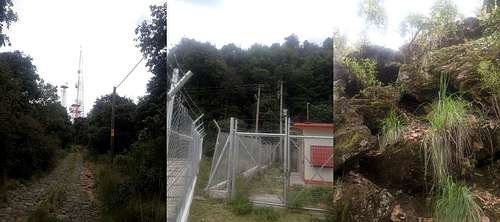
Left: Almost at the antennas / Middle: Small passage to the summit / Right: Near the summit!
Red Tape
Only the antennas aren't accessible. Furthermore, there is no restriction or fee of any kind.When to Climb
The hill can be climbed year round. During the wet season (May to October), be sure to check the weather forecast, especially if you plan on staying there in the afternoon.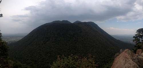
Majestic El Pinal from the summit of El Tintero
Camping
I wouldn't recommend it, as only the extensive switchbacks or the antennas would provide enough flat room to fit a tent. If you desperately wish to camp in the zone, better go to El Pinal, cerro Xalapasco or one of the 'barrancas' located nearby, like Cañada Los Pilares.External Links
- Cerro El Tintero on Wikiloc
- Cerro El Tintero on "Bailando con Sarrios": a travel report with lots of photos