
-
 20474 Hits
-
 87.31% Score
-
 24 Votes
|
|
Mountain/Rock |
|---|---|
|
|
42.57360°N / 18.35250°E |
|
|
4048 ft / 1234 m |
|
|
Overview
Sniježnica is not very high mountain in Dinaric mountain range but it is very accessible and attractive one. Its height is easy to remember, just count 1..2..3..4.. and you get exactly 1,234 meters above sea level, thus making Sniježnica the southernmost Croatian peak above 1,000 m meters of height. Thanks to its isolate position, steep above fertile Konavle field and the vicinity of the sea, it looks higher and can give you wonderful panoramas of both carstic mountains of Herzegovina (region in Bosnia&Herzegovina) and Montenegro inland, as well as azure-colored Adriatic sea and its islands. So anyone of you who is going to spend your holidays in Dubrovnik area - and you´re a mountain freak - don’t miss this mountain – and don’t let its height of just 1,234 meters deceit you.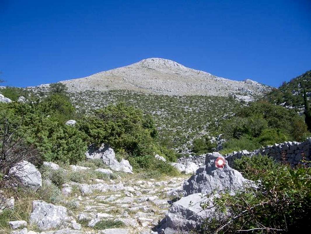
The peak of Sniježnica mountain is called Sveti Ilija (St. Elias), and close to the summit point you will see a small chapel devoted to the Saint, a place of seasonal pilgrimage in his honor and other religious festivities.
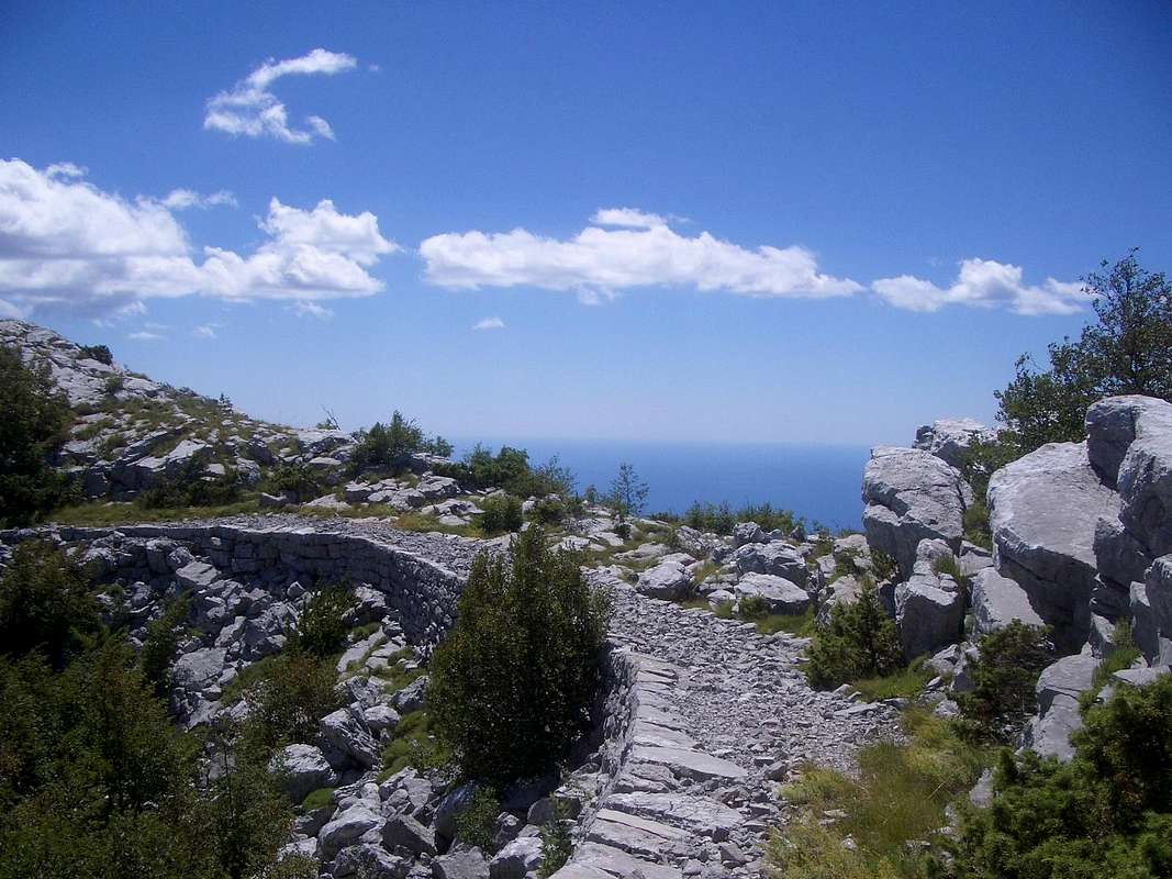
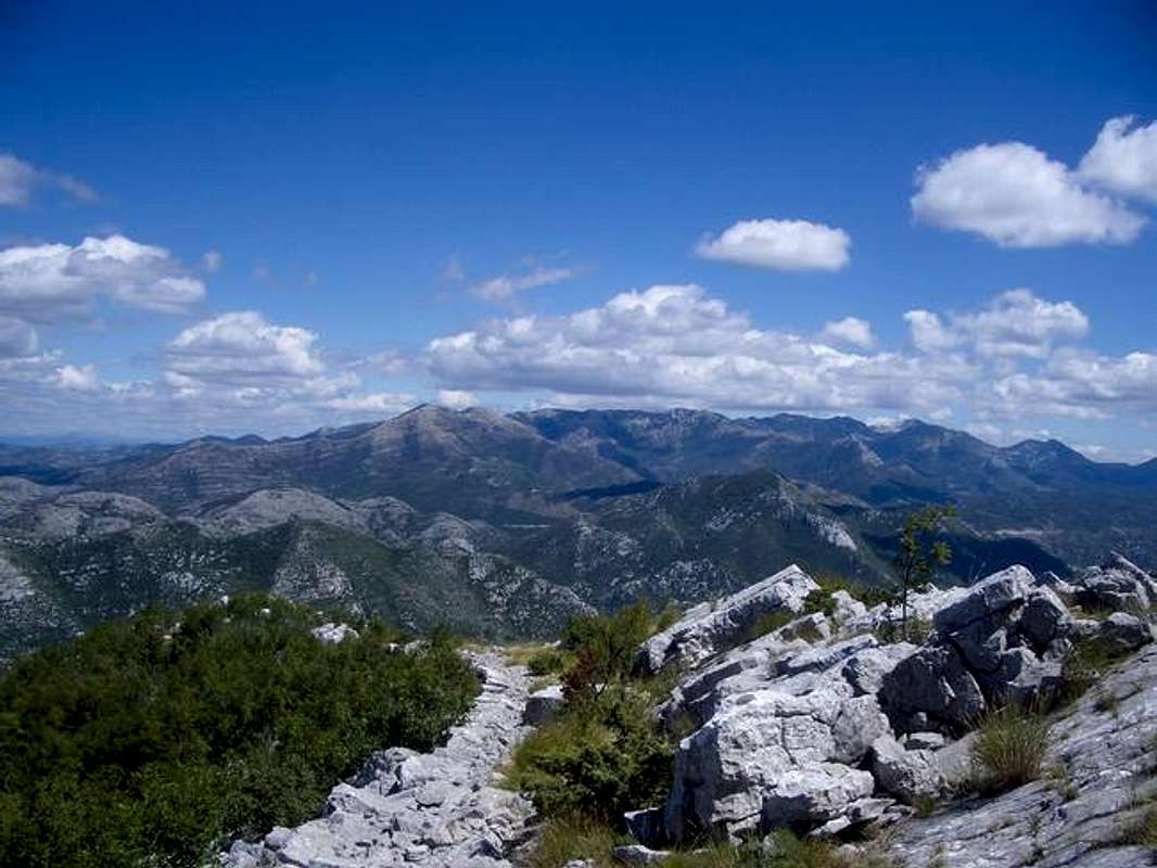
Panorama from Sniježnica on a clear day is unexpectedly wide and amazing. You could see mountains of Herzegovina (Kamesnica, Cvrsnica, Cabulja, Velez, Prenj, Zelengora, Lebrsnik, Maglic), the mountains of Montenegro from Durmitor to Sinjajevina), the mountains of coastal Croatia (Sveti Ilija on Peljesac peninsula and Biokovo mountain) islands of central and southern Dalmatia and Dubrovnik area (Mljet, Korcula, Lastovo, Elafiti), coastal mountains of Montenegro and the entrance to magnificent Boka kotorska bay.
As mountain Orjen is the closest neighbour of Sniježnica, and since Sniježnica on a map looks like a small satellite to huge Orjen, this mountain dominates the panorama from Sniježnica – you may think to grab Orjen by your own hand – but don't do it, because Orjen belongs to another state, Montenegro (officially the state of Serbia and Montenegro)!
And last but not least, the gem-city of Dubrovnik can be seen from Sniježnica - the same way Sniježnica can be seen from Dubrovnik especially in winter time with its very recognizable white snow cap – wherefrom Sniježnica got its name (“snijeg” means snow in Croatian). And sheer look of snowy cap of Sniježnica almost every winter, was probably strong motif for Dubrovnik inhabitants, who rarely experience snow in their own city, to name the peak after word for snow.
Climbing Sniježnica is a relatively easy task, most of the times it is a day or half day effort, depending on the route you plan to take.
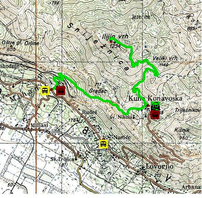
There is only one major way to the top used by visitors - but you can choose between two variants. You can start your ascent in the village of Mihanici (250 m above sea level) in Konavle field to get to village Kuna (700 m above s.l..) in 1,30 h, or come by car (from village Pridvorje also in Konavle field) all the way up to Kuna where from you have 2 hours of walk to reach the summit of Snijeznica.
Most of your ascent from Mihanici to Kuna your trail will follow old village road that inhabitants of Kuna village used to get to old railway station in Mihanici (it does not exist any more). And most of your trail from Kuna to the summit follows old military roads “mulitjere” (or “mulitiere” – the name comes after word for an animal - mula in Croatian, or mule in English), thus showing such roads were built for those animals that carried cargo to military outposts in surrounding hills more than a century ago.
When climbing Sniježnica on surrounding slopes you should notice a real network of such old wide stony roads Austro-Hungarian Empire built for strategical purpose because this was always border area where three states met and still meet (Bosnia and Herzegovina – previously Ottoman Turkey, Montenegro and Croatia). And the village of Kuna was border post at the time, as still is today. Since the trail follows one of those easy accessible and good planned roads most of the time, climb to Sniježnica is a real pleasure!
Getting There
The best way to get to Sniježnica is from Dubrovnik/Cavtat area. Thanks to its good tourist infrastructure getting to Dubrovnik should not be a problem, although local buses from Dubrovnik or Cavtat to the foot of Sniježnica are not too frequent.Geting to Dubrovnik/Cavtat by plane: Dubrovnik airport is located in Cilipi, the village in Konavle field, close to the town of Cavtat 5 km and 17 km from Dubrovnik. Dubrovnik has regular commercial flights to many cities in Western Europe (most flights to Germany, Great Britain, France; Austria etc) and to other Croatian airports. During summer lot of charter and seasonal flights to many other posts exist.
Info at:
Airport Dubrovnik
Croatia Airlines
Getting to Dubrovnik by boat: Dubrovnik is linked to other Croatian coastal cities (Rijeka, Split, Zadar and other coastal places) by ferries operated by Jadrolinija Steamship company. Dubrovnik is also linked with Bari in Italy with Car Ferry Service.
Info at:
Jadrolinija
Getting to Dubrovnik/Cavtat by car: The main direction to come to Dubrovnik by car is by the Adriatic road from Split direction (Split to Dubrovnik is 218 km). Other possibilities to come by car are >b>from Bosnia and Hercegovina, via Sarajevo and Mostar (Mostar-Dubrovnik, 147 km), and from Montenegro (Kotor-Dubrovnik, 80 km).
When coming to Dubrovnik from Split direction be aware that in the area of Neum you will cross territory of Bosnia and Herzegovina for some 10 kms and you could expect some kind of custom control the same as on entrance or re-entrance to Bosnia and Croatia.
Info on road conditions in Croatia and other similar info at:
HAK - Croatian Auto-moto Club
Getting to Dubrovnik by bus: You can reach Dubrovnik by bus from Austria, Italy, Germany, Hungary and Slovenija (regular lines) and from many cities and towns in Croatia.
Info on buses to Dubrovnik at:
Buses to Dubrovnik
Zagreb Bus Terminal
Buses from Dubrovnik and Cavtat to village of Mihanici: You can info on local bus lines (schedules and transport maps) at:
Libertas
 |  |  |  |  |
Red Tape
On this place I will put anything that can theoretically be dangerous when climbing Sniježnica but you should REMEMBER that problems happen very very very rarely (sincerely I haven’t heard anything since). Even “innocent” tourists climb the peak!Weather: The worst “enemies” are the Sun and winds, so accommodate to actual conditions.
Mines: Be aware that during the War in Croatia ten years ago this area was a war zone and still is a border zone – so just in case, follow the trail and main roads. The trail itself is difficult to miss. Even when you don’t see a mark for the moment the sheer look of the trail will let you know where you should go. This in NO reason at all to give up from Snijeznica´s climb!!!
Animals (only dangerous ones :-) ): Snakes are present like everywhere on the Mediterranean and in the mountains - respect them, they will respect you. If you think about them as a “biodiversity stuff” you will psychologically feel much better!
Border area: Although you will read in some older guidebooks that this is border area and therefore you should report your moving around to local police station, it is an OLD FACT - in reality most of the time you will not be able to see or find a single policeman not even a police station in Kuna. And since tourism is No 1 business in the area lots of people and tourists move around and climb Snjeznica without any problems and without any permission. Just stick to “official” trail to the summit of Sniježnica, and you will never have such problems and you dont need any permission. Just in case, always have an ID of any kind with you.
When To Climb
Sniježnica is accessible to climb almost all year (including when under snow in winter).Spring and autumn are probably the best periods thanks to pleasant temperatures, good quality of air and easy-to-find accommodation in Dubrovnik/Cavtat area.
Summer can be very nice because of lots of sunshine and easy backpack, but be aware of high daily temperatures and lack of vegetation and shade along the trail. So take lots of water with you and avoid sun peak period. Also the air visibility in summer (unless after good rain or wind, or during sunsets) could be lower than during the best periods (spring and autumn), but this should not be a problem.
Winter: As Sniježnica got its name from the word for snow there will be snow on its summit for sure during most winters, but because of its accessibility and short climb many people climb the mountain this time of year because of very clean air and panorama of snow capped mountains in the hinterland.
Other: Because of Snijeznica´s position (and this warning stands for most of eastern Adriatic coastal mountains too) you should be aware of existence of two prevailing winds which can mark your ascent. These are "bura" (English “bora”) northern chilly wind, very strong on moments, blows from the mountains towards the sea, bringing improvement of weather, and clear sights most of the times, and the second one "jugo" (jug means the South) when warm humid air blows from sea to inland.
More info on prevailing winds along the eastern Adriatic coast at: Winds of the Eastern Adriatic
Camping & Accomodation
As climb to Sniježnica is a day trip you will rarely get to an idea to camp on the mountain. If your intention is to spend overnight at the summit f.e. to wait for sunrise moments no one would care and I see no obstacle to do it.Because Sniježnica is close to Dubrovnik Riviera, camping places or other ways of accommodation can be found in surrounding area without problems, although in summer they can be crowdy.
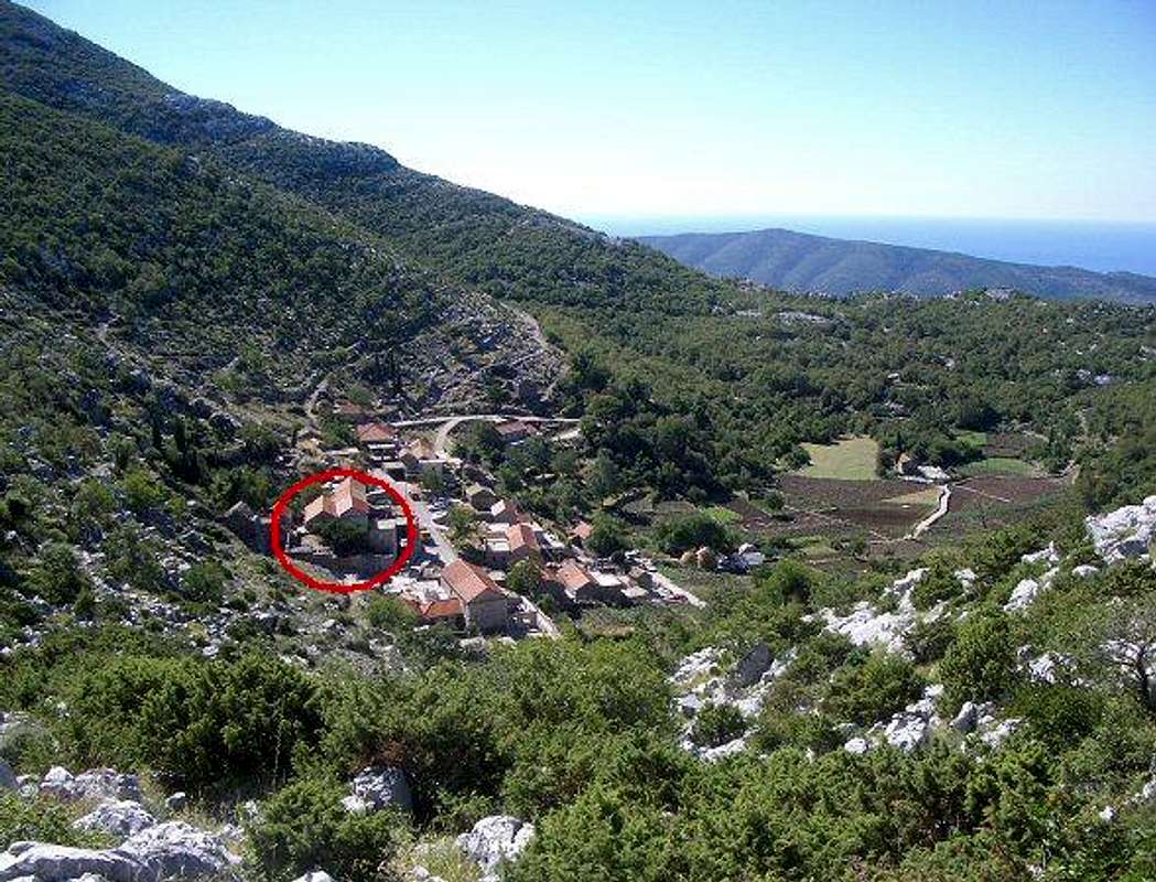
In the village of Kuna, just where the trail starts to the summit od Snijeznica, stands a Mountain house “Pavlic” (h: 700 m), with 12 sleeping places, water, electricity. The house is closed most of the time and if you want to use it you should arrange it previously by contacting the maintainer. And the house is maintained by a Mountain club “HPD Dubrovnik” - person to contact for using the house is Mirjana Karaman phone: 00385 20 357 535, and moby. 00385 91 570 8460, e-mail: mirjana.karaman@du.htnet.hr) - on a photo attached you can see exact location of the Mountain house in Kuna village.
THE LATEST INFO: Mountain Lodge Pavlic is out of function since summer 2010. It has been replaced by another one nearby (former school; 200 meters further) in the same village and with another name: Mountain House Kuna konavoska.
Mountain Conditions
You can find information on weather condition in the area from standard weather information sources for Croatia. The nearest meteo-stations are Cavtat (Dubrovnik Airport) and Dubrovnik. But be aware that the weather at the top of the mountain can differ from that along the coast, no matter the fact that from Sniježnica summit is only 7 kilometers away from the coastline. Many times the coastline is sunny and Sniježnica fully in clouds for days.DHMZ-english page
DHMZ-forecasts in English
Weather in Dubrovnik area
You can see local weather on the hills close to Sniježnica by a web-cam positioned at Dubrovnik Airport situated just below Snijeznica, at:
Web CAM Airport (4 live camers showing the area)

Maps
 |  |
Another practical map: HPS - Croatian Mountaineering - Map of Snijeznica
Dinaric-ZG - Oct 19, 2005 4:31 am - Hasn't voted
Untitled CommentThank you for posting the correction. I´ve been out of internet for few months and could not post this change before.
Take care!
Gord
1234svilija - Oct 11, 2005 8:38 am - Hasn't voted
Untitled CommentPerson to contact for using the house "Pavliæ" in the Kuna Konavoska is not Katija Vlahušiæ and phone 419 345 and moby. 098 164 12 42.
Person contakt is Mirjana Karaman phone: 00385 20 357 535, and moby. 00385 91 570 8460, e-maill: mirjana.karaman@du.htnet.hr
Look in the Web page Hrvatskog Planinarskog Saveza:
hps.inet.hr
Dinaric-ZG - Oct 19, 2005 4:31 am - Hasn't voted
Untitled CommentThank you for posting the correction. I´ve been out of internet for few months and could not post this change before.
Take care!
Gord
blizzardofone - Dec 21, 2014 1:41 pm - Voted 7/10
late December, no snowThanks for the thorough run down. It is a lovely peak. We climbed from Mihanici two days ago in splendid conditions. There are a couple fallen trees and one confusing spot at the top of a ridge where a shepherd (??) has built a wooden barricade across the path, but in all cases it is easy to walk a couple meters around the obstacle. On the descent we did indeed encounter some of that "biodiversity stuff," but it slithered off the trail promptly. One more thing to add for would-be hikers is that while the trail is very good in parts, it is quite rugged and tough to follow in others. Just keep an eye out for the red-and-white spots painted on rocks to guide you -- and bring solid for the rugged terrain! This was our first real hike in Croatia and we fell in love. Happy hiking to everyone else!
Dinaric-ZG - Jan 6, 2015 5:30 pm - Hasn't voted
Re: late December, no snowThanks a lot for updating the description of the route! Take care!
bdejong - Jun 21, 2015 4:53 am - Hasn't voted
Hike up from KunaMy 7 months pregnant (!) wife and myself hiked up from Kuna 2 days ago. We left early in the morning from Dubrovnik and the hike up was splendid. Hiking down again was more difficult because it was getting super warm. All in all everything was marked really well. There is one alternative a bit above Kuna where you can follow the military road around a few pastures or take the more difficult hike straight up (which is the one marked with red-white spots). If you don't like clambering down over steep terrain it's pretty easy to spot the roundabout way via the road from above. We saw no snakes but plenty of rather large (35-40 cm!) lizards who where really curious after they scuttled away and always came up again to stare at us! :)