
-
 15229 Hits
-
 92.32% Score
-
 38 Votes
|
|
Mountain/Rock |
|---|---|
|
|
42.93556°N / 18.99722°E |
|
|
Hiking, Mountaineering, Sport Climbing, Canyoneering, Skiing |
|
|
Spring, Summer, Fall, Winter |
|
|
6555 ft / 1998 m |
|
|
Intro
The most striking and most interesting mountains of Montenegro form its central mountain area (Brda). These moutains rise from surrounding mountain highlands cut by deep river canyons. This high mountain area is dominated by two major sub-ranges. The first one, the "outer row", predominantly made of limestone, and rich in karstic formations, consists of Golija (1,942 m), Vojnik (1,998 m), Maganik (2,139 m) and Prekornica (1,926 m) mountains. This group of mountains share similar geomorphological characteristics and they split the teritory of Montenegro into two geographically and climatically distinct areas: Mediterranean/sub-Mediterranean and Mountain/Continental part. Like the most of the Dinaric Alps chain, these mountains spread in classical Dinaric direction: NW-SE.Deeper inland, the second row of high mountains runs from NW from Volujak, Maglić and Bioč mountains on the borther to Bosnia&Herzegovina, then Ljubišnja, Durmitor, Sinjajevina, Bjelasica, Komovi to Prokletije range to SE.
Vojnik mountain, with its summit Veliki Vojnik (Large Vojnik 1,998.40 m), is a large limestone mountain in central-western part of Montenegro, situated north of the town of Nikšić in Nikšić field (the largest karstic field in Montenegro), and southwest of the town of Šavnik. Vojnik is separated from surrounding Montenegrin mountains (which are Maglić, Volujak, Bioč, Durmitor or Morača mountains) by highlands or deep river canyons. Vojnik mt. is also less known and less visited, comparing to its previously mentioned mountain neighbors.
  |
Overview
Situation and BordersVojnik mountain with its wider mountain area spreads north of Nikšić field ( Nikšićko polje, orig.), west of Krnovo plateau and the mountain pass of the same name, east of Javorak forested mountain area with Javorak mountain pass, and south of Komarnica and Bukovica river canyons.
The central part of the mountain is 20 kilometers away from the town of Nikšić, in northern direction, and in wider sense it is considered that the the southernmost slopes of larger Vojnik area reach northern parts of Nikšić field. Vojnik mountain itself (its southern face and slopes) dominates the northern Nikšić´s horizont.
In narrower geographical sense (the core of the mountain) the borders of Vojnik are:
Ü To south: canyon of periodical river called Surdup;
Ü To east: Gradačka Poljana (settlement) - Krnovska glavica (or Krnovska glava, peak) - Bijela (river) – Šavnik (small town);
Ü To north: Bukovica (river, in some parts of its flow also called Pridvorica,) - Komarnica (river) – Brezanski Lug (settlement) – Brezna (village and plateau);
Ü To west: Veliki Stojkovac (peak) – Javorak (mountain pass) – Jasenovo Polje (village on Plužine – Brezna – Nikšić main road).
Krnovo high plateau (alt. 1,450 m) makes a distinct eastern border of Vojnik mountain, separating it from Lola and Žurim mountains (in Morača Mountains group) more to the east. This plateau is covered with pastures and meadows. It is well known for harsh winter conditions - with snow blizzards, high snow-drifts and frequent traffic brakes.
Krnovo is also the name of a mountain pass between the mountains of Vojnik and Lola on the old Nikišć-Šavnik road (the new road passes more to the west, starting from Nikšić, over Javorovo Polje village to Mokro and Šavnik).
 |
On its western and south-western side, Vojnik mountain adjoins Javorak, somewhat lower laying forested mountain area that separates Vojnik mountain from Golija mountain more to th west. Javorak is also a high karstic watershed separating Nikšić field to the south from valleys and canyons of Piva and Komarnica rivers in the north. An important road connection passes through Javorak connecting the town of Nikšić (and Central and South of Montenegro), over Piva area/region (Pivska župa) and the small town of Plužine, with Drina river canyon and the town of Foča, in Bosnia and Herzegovina.
To the north, all the way from the town of Šavnik (on the NE side), to Brezna plateau more to NW, Vojnik mountain descends sheerly and steeply into famous Komarnica river canyon and its tributary Bukovica. North of Komarnica river canyon slopes of Treskavac mountain rise (with its summit Buručkovac, 2,094 m), as the southernmost part of Pivska planina (Piva´s mountain).
On its north-western side Vojnik mountain descends to Brezna highland, a larger plateau between Komarnica canyon and rich forests of Javorak and Golija mountains. There are more settlements on Brezna as are Brezna (Upper-Gornja Brezna> and Lower-Donja Brezna) and Bajovo Polje, all belonging to Plužine county and Piva region - a region in NW Montenegro, around Piva river and between Durmitor and Maglić-Bioč-Volujak-Vlasilja mountain group.
Actually, Vojnik mountain belongs to three traditional regions of Montenegro: to southern parts of Piva and Drobnjak regions and northern part of Nikšić region. Administratively, the mountain area is shared by three counties: Nikšić 42%, Plužine 27% and Šavnik 31%. The summit of Vojnik is also administrative three-border point of these counties.
 |
Morphology and Geology
Morphological Features
Vojnik mountain is roughly 17 km long and 8 km wide, covering app. the area of 140 sq. kms. There are 48 peaks rising over 1,500 m. Average mountain altitude is about 1,650 m.
The highest peak of the mountain is Veliki Vojnik (Large Vojnik), marked by a trigonometrical point with the altitude of 1998,40 m. The summit is also administrative three-border point of Plužine, Nikšić and Šavnik counties.
Other dominant peaks are Gradno brdo (1,961 m) and Mramorje (1,920 m).
The mountain rises around 900 meters up from three surrounding plateaus (highlands) of almost the same height (around 1,000-1,100 m). Those plateaus are: Brezna, Jasenovo Polje and Mokro. In some parts it rises more than 1,200 m from surrounding terrains like above Bukovica (in some parts also called Pridvorica) river canyon, or just 500 meters above Krnovo highland.
The attractivity of the mountain lays not only in its steep slopes, wildness, forests or broadvsummit views but also in attractive deep river canyons that surrounds it. These are canyons of Komarnica, Bukovica (in one part also called Pridvorica), Piva, Bijela and Surdup.
The most attractive view on Vojnik is of its northern side, especially when seeing it from from the north, from the southernmost parts of Durmitor and Pivska planina mountains. From there, one can see at least 7 to 9 steep limestone peaks, lined up in NW-SI direction with more cols between them. Here are Vojnik´s slopes very steep, descending deeply into canyons of Komarnica and Bukovica (Pridvorica) rivers.
This central part of Vojnik´s northern side, above Bukovica (Pridvorica) river canyon (on this part 750 m high) is an area called Kondžila, it is the mountains steepest part, cut by many dry-culoirs and ravines. This is hardly passable area, without mountain roads and rare mountain paths. Because of its ruggedness this is the area of well preserved broadleaf and coniferous forests.
Furthermore, Vojnik´s northern slopes descend steeply and in more steps to NW toward Brezna highland (1,250 m) and to NE toward Mokro village.
To NW and west Vojnik´s slopes are milder, less rugged and covered with beech and coniferous forests. Here, close to rounded Štuoc peak and Javorak area (forested karstic basin with man road passing through) there is Gola strana (Barren slope, transl.), a barren crest (1,400-1,600 m high) where the western part of ancient Vojnik´s glacier split into two parts – the first branch remaining in neighboring Živa area and the second part extending in Brezna plateau direction. Živa area is around 150 meters higher than Brezna plateau separated from Brezna by a rugged forested spur.
Eastern slopes of Vojnik are pretty steep, rugged and covered with beech forests. They spread all the way to Meki Dolovi in Kuševice village, and to Krnovo and Gradačka Poljana areas. This part of Vojnik is more complex in morphology, with more fractured mountain areas looking as if they were separate mountains. There are more lower peaks in this area covered with forests as well as some good pasture areas.
On its southern side Vojnik gradually descends toward Nikšić field (Nikšićko polje, orig.). Sotuhern slopes are the mildest on Vojnik. There are three dictinct plateaus in this part of Vojnik: Šipačno, Jasenova Poljana-Praga and Štirni dô (with Zminjac water-spring). On many places, those terraces are covered with beech forests in lower parts and with coniferous trees on higher grounds.
 |
Geological Structure
Vojnik is a rough mountain, made of Jurassic and Cretaceous limestone, together with dolomites. These rocks have been shaped and still being reshaped by intensive erosion processes. Vojnik today is a type of a Dinaric mountain with the highest level of karst type terrain.
Milder forms on Vojnik are products of decomposition of slab-like marleous (of marl) Jurassic limestone.
The foot of the mountain is made of werfen era slates and sandstone rocks, which is clearly visible in river Bukovica riverbed.
One of main characteristics of Vojnik is a presence of more moraines, remaining after glacier meltdown at the end of geological period of Pleistocene (10,000 y.a.).
There were more glaciers on Vojnik during the Ice Age. Glaciers had formed in valleys and fields of Vojnik and the largest of them descended into Komarnica river. The longest glacier was around 5 km long and finished in Živa basin. One large ice mass was present on NE side of Vojnik and was fractured in more directions.
Smaller glacial traces were left on the northern side of Vojnik, in Kondžila area. It was a glacier spreading in direction of Bukovica-Komarnica riverbed, but which left only a small amount of moraine material because rivers had taken away the most of it during younger geological history.
In all other areas of Vojnik where glaciers had been present, more of moraine material had remained until these days.
One of such glaciers, on north-eastern part of Vojnik, run into hard limestone, beneath contemporary village of Mokro, split over Mokro plateau (Mokarska ravan) and melted there leaving moraines. In another glacial period the glacier on the same location was smaller, too short to reach Mokro, instead had reached Divan area (above Mokro) only, and retained here, where at last melted and left more of moraine material. So this part of Vojnik has moraine materials present on two plateus (Mokro, at cca 1,092 m alt.) and Poljic mokarski katun (at 1,525 m alt.). Katun – is a traditional term for a periodical shepherds´ settlement.
 |
On eastern part of Vojnik glacier descended in steps to Krnovo plateau then to Vučje, from Vučje to Bukovik and from Bukovik to Veliko Lukovo (Large Lukovo) and Malo Lukovo (Lesser Lukovo) plateaus. Moraine material from this part of Vojnik had been disseminated to lower parts by local streams and water currents. Therefore you can find large quantities od stone pbbles, that resembles to fluvial ones.
To south, a glacier settled in Štirni do (a field), an area between Vojnik, Gradni vrh and Prisiren peaks. From here it made its path (also leaving a lot of moraine material here) over depression running just bellow Štirni do and finally descended to Jasenovo polje plain, whih is today covered with more moraine tops.
To west the glacier that descended from Vojnik formed two terraces, the first one iz Živa and the second one is Brezna. More limestone moraine material could be find even today in Živa and Brezna.
It is an interesting fact that moraine material had been deposited from Vojnik in all directions to almost the same height to the altitude of cca 1,050 meters (Mokro 1,092 m; Lukovo 1,032 m, Jasenovo polje 1,046 m and Brezna 1,055 m).
 |
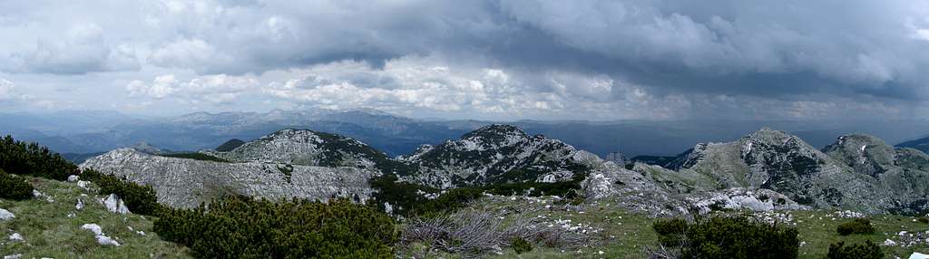
Summit Views
Broad views from the summit of Vojnik enable us to observe interesting morphology of Vojnik mountain and surrounding areas of Montenegro.
Northern Views
To the north of the summit, behind a deep valley of a shear limestone there is a unnamed 1,940 m high peak covered with juniper-trees. More to the east across Crnogorska vala (a depression), more rocky and grassy tops rise from high mountain ridge, and the highest of them Gradno brdo (1,963 m) and Mramorje (1.920m). Behind those peaks, more to the north, is a rugged area called Gradne doline (doline means valleys) the least explored part of the mountain. Gradne doline is a glacial recess, a medley of sheer rocks, loose screes, ravines and gorges. It continues all the way down to Kondžilo area and cliffs of Komarnica canyon.
Behind the northernmost slopes of Vojnik mountain deep bellow lays Komarnica canyon – but it is not visible from the summit. Behind the canyon, dominating the horizont further to the north is a vast highland in Piva region with Pivska planina mountain and west of it a highland in Drobnjak region with steep slopes and high peaks of Durmitor massif.
When looking in Durmitor direction one can see Boljske grede (Bolj´s rock, cliffs) dominating its foreground, rising almost 700-800 meters vertically above the upper part of Komarnica river flow. Behind Boljske grede you should notice 20 kilometers distant Bobotov kuk (at 2,522 m the highest peak on Durmitor), as well as the other major peaks on Durmitor (Minin bogaz, Bezimeni vrh, Prutaš, etc.).
Many consider the view of Durmitor from Vojnik mountain as one of the most beautifull sight of this famous mountain massif, because from this viewpoint you could see Durmitors´ greatness.
North-Eastern Views
To the North-East, over Bukovica river canyon and small town of Šavnik deep bellow one can see the vast highlands and mountain-tops of Sinjajevina massif.
 |
Eastern Views
East of the summit of Vojnik some of the highest peaks of Vojnik rise, as are Gradno brdo and Mramorje and further - continuing to the east - somewhat lower mountain ridge all the way to Krnovo mountain pass and Krnovo plateau. Further away from Krnovo in the distance the view is dominated by more mountains of Morača Mountains group (Lola, Kapa moračka)
South-Eastern Views
High mountain plateau Krnovo dominates the south-eastern view from Vojnik. Behind Krnovo more mountain plateaus of glacial origin can be seen, and they are: Vučje, Konjsko, Bare Bojovića, Luke Bojovića and Lukavica. Behind this plateaus, parts of Morača mountains rise (like Žurim), as well as Maganik and Prekornica massifs. Far behind them on very clear days one can see all the way to sharp peaks of Komovi massif and Prokletije mountain range - on border between Montenegro and Albania.
Southern Views
When looking from the summit of Vojnik in southern direction, behind lower peaks of wider southern Vojnik area (like Studena peak at 1,574 m) one can see 15 km long Field of Nikšić polje (Nikšićko polje, orig.) with the town of Nikšić (pop. around 60,000) and large Krušice lake (Krušičko jezero, orig.) an artificial hydro-accumulation. Nikšić field with its 48 square kilometers one of the largest karstic fields in the Dinaric Alps (sprawling at alt. of 622-690 m). Further to south there is rugged and karstic Katunska nahija region, ending with high mountains of Lovćen and Orjen (some 60-km away), behind which lays the Adriatic sea.
 |
South-Western Views
To the southwest one can notice rugged karstic areas dominated by a few elongated higher mountains stretching in Dinaric direction as are Njegoš and Somina.
Western Views
When seeing in western direction lower forested area Javorak dominates the view and behind it Šišman area and Golija mountain.
North-Western Views
To the North-west of Vojnik there is a nice view of vast Piva river basin with attractive canyons of Piva and its tributary Komarnica. Lots of villages are scattered around both sides of the mountain. Deep behind in the background in direction of Bosnian-Herzegovian border large masses of Volujak, Bioč, Vlasulja and Maglić mountains rise.
Vojnik Mountain and its Peaks
Table 1.
GPS Source: Rumbletum | ||||
| Peak | Height | Position Lat/Lon | Photo | |
| Veliki Vojnik (Large Vojnik) | 1,998.40 m | 42.9355556° N 18.9972222° E |  | |
| Gradno brdo / Gradni vrh | 1,963 (1,960) m | 42.94433° N 19.0126° E |  | |
| Mramorje | 1,920 m | 42.9325° N 19.0211111° E | - | |
| Klekove glavica | 1,833 m | 42.9419444° N 18.99° E | - | |
| Jablan brdo | 1,774 m | 42.9144444° N 19.0622222° E | - | |
| Mali Vojnik (Lesser Vojnik) | 1,773 m | 42.9569444° N 18.9855556° E | - | |
| Golo brdo | 1,749 m | 42.9213889° N 19.0325° E | - | |
| Golopus | 1,744 m | 42.9072222° N 19.0688889° E | - | |
| Troglavi | 1,673 m | 42.9111111° N 19.0308333° E | - | |
| Runjavac | 1,668 m | 42.9405556° N 18.9769444° E | - | |
| Veliki Štuoc (Large) | 1,654 m | 42.9625° N 18.965° E |  | |
| Mali Štuoc (Lesser) | - | 42.9619444° N 18.9547222° E | - | |
| Orlovo brdo | 1,654 m | - | - | |
| Komadarino brdo | 1,593 m | 42.8894444° N 19.0816667° E | - | |
| Gole strane | 1,576 m | 42.9419444° N 18.9491667° E | - | |
| Studena | 1,574 m | 42.8508333° N 19.0361111° E | - | |
| Veliki Siljevac (Siljevac) | 1,517 m | 42.8797222° N 19.0572222° E | - | |
| Ljeljenov vrh | 1,406 m | 42.8702778° N 19.0058333° E | - | |
| Veliki Stojkovac (Stojkovac) | 1,369 m | 42.9733333° N 18.9133333° E | - | |
| Kita | 1,338 m | 42.9319444° N 18.9458333° E | - | |
 |
Table 2.
GPS Source: Rumbletum | ||||
| Name | Altitude | Position Lat/Lon | About | |
| Štirni dô | 1,520 m | 42.9266667° N 19.0044444° E | Field, katun | |
| Štirni dô | 1,520 m | 42.9344444° N 42.9344444° E | Field, katun | |
| Živa | - | 42.9561111° N 18.9258333° E | Katun, Pastures | |
| Štavna Aluga | - | 42.9302778° N 18.9763889° E | Area, locality | |
| Vioš dô (also Vioć dô) | - | 42.9186111° N 19.015° E | Field, former katun | |
| Bakilj | - | 42.9066667° N 19.0147222° E | Area, locality | |
| Mustafini doli | - | 42.925° N 18.9375° E | Depression | |
| Lipova Ravan | 42.9147222° N 18.9475° E | Area, hamlet | ||
| Savova (Savina voda) | - | 42.9719444° N 18.9519444° E | Spring | |
| Živsko razdolje | - | 42.9494444° N 18.9475° E | Area, Valley | |
| Krnovo | 1,487 m | 42.8908333° N 19.1011111° E | Mountain pass | |
| Javorje | 1,331 m | -° N -° E | Mountain pass | |
| Mramorje | 1,660 m | -° N -° E | Col | |
| Šavnik | - | 42.9563889° N 19.0966667° E | - | |
| Jasenovo Polje | - | 42.8930556° N 18.9661111° E | - | |
| Praga | - | 42.8808333° N 19.0230556° E | - | |
| Gornja Brezna | - | 42.9855556° N 18.9655556° E | - | |
| Gvozd | - | 42.8594444° N 19.0691667° E | - | |
| Mokro | - | 42.9330556° N 19.065° E | - | |
| Miloševići | - | 42.9175° N 19.11° E | - | |
| Pošćenje | - | 42.9744444° N 19.0658333° E | - | |
 |
Other Features
The NameVojnik means a soldier in local south-Slavic languages. Because of this name and harsh weather conditions that prevail on Vojnik, especially in winter time, one popular saying emerged among local people, that is: Vojnik mountain ("Soldier" mountain) is the only soldier before which even generals buttoned up (their coats).
In some older sources (the beginning of 20th century, f.e.) I have found some authors calling this mountain as Mramor mountain (with mentioned height of 1,930 m) which somehow resembles to today´s name of Mramorje peak (1,920 m).
Hydrological Features
High average precipitation and large spring snow meltdown dissolve the limestone of Vojnik in large degree, forming karstic shapes (funnel shaped holes, flutes, etc.) in a short period of time.
Usually, snow can be up to 2-3 meters thick. But during snow meltdown, because of limestone basis, and southern exposure, the most of this water perish through channels on bottom of sinkholes. Generally, surface water on higher parts of Vojnik is very scarce because of its geological structure. Even the snow remains during summer in smaller quantities comparing to other Vojnik´s mountain neighbors.
Despite its dominant karstic structure, there are some parts of the mountain with more abundant springs. This is especially in lower parts of the mountain. One of such areas is on eastern part of Vojnik where short water streams occur in Krnovska glava area and vicinity of Miloševići and Mokro villages. In Živa and Vioš do areas there are water sources but they dry out in summer. There are more periodical stagnant water forms on the mountan, like some pools in Štirni do, Štavna aluga and Mršina voda, mostly used for animal (cattle, shep, horses) watering.
Vegetation
30-40 years ago Vojnik mountain was famous for its thick beech and coniferous forests that covered more than 75 percent of its mountain area, and Vojnik was considered to be one of the most forested mountains in the wider area. But then, uncontrolled felling of trees followed and forested area was reduced to just 40 percent of the mountain area.
Although Vojnik still abounds in coniferous and beech forests around its foothills, it has still being exploited relentlessly. Therefore, when walking over Vojnik, especially over southern and south-western parts of the mountain, you should encounter a developed network of forest exploitation roads. The only major exception from this rule is the NE area of the mountain (in direction of Komarnica river), where forest exploitation is almost impossible due to steep and rugged slopes.
The upper tree-line on Vojnik is at around 1,750. Forest habitats of Vojnik consist of beech, maple, ash-tree, spruce, fir tree, pine tree, bitter oak and other varieties of trees.
Vast areas of beech and pine tress cover its north-eastern slopes. In these parts trees cover the mountain all the way to its summitops. Juniper trees grow around the most of other Vojnik´s summits, except some exemptions as are peaks of Mramorje and Korijen.
There are around 2,500 registered plant species on Vojnik, some of them endemic, and lots of them medicinal herbs.
 |
Settlements on Vojnik
There are more picturesque mountain valleys and terraces with mountain pastures on Vojnik, especially in the areas of Štavni do, Štirni do, Vioš do, Živa and Lipova raven. In these valleys more katuns (periodical summer´s shepherd´s settlements) existed – with more than 30 shepherd´s families arriving each summer. Nowadays only katuns Štirni do and Štavni do (under southern slopes of Vojnik summit) are still active. Both katuns are situated between the end of forest and steep and almost barren slopes of Vojnik summit. Shepherds are present here from the end of May all the way to the mid-September.
When to Climb
The climate of Vojnik is largely influenced by the vicinity of the Adriatic sea. Because of these maritime influences the largest amount of precipitation is in November, December and March and the driest month is August. Yearly average of precipitation for Vojnik mountaineous area is higher than 2,000 mm of precipitation, but unevenly distributed throughout a year.The highest parts of Vojnik belong to mountaineous climate characterized by harsh, snowy and long winters and short summers. Winters usually last for 5-6 months, with snowfalls starting early, sometimes in November and during winter time the whole parts of the mountain are usually cut off from the rest of the World for 2-3 months (though the last few years winters have been relatively mild). Lowest winter temperatures can drop to minus 20 degrees Centigrade, sometimes even lower.
The snowlayer in winter can be more than 1-2 meters thick, and even higher on surrounding highlands. It can last for 4 to 5 months. It is light and dry in winter and dump and heavy in late autumn and early spring. In winter period strong and cold winds blow over Vojnik mountain area. Surrounding areas especially river canyons and lower laying highlands are very often under the fog, and the temperatures there are even lower.
Transition periods from winter to summer (spring) and from summer to winter (fall) are followed by frequent precipitations (rain mostly, many times with hail, especially in summer)
Summer temperatures can be high, even in mountaineous areas, especially on southern slopes (with recorded maximum around 30 degrees Centigrade).
The climate on lower southern (in direction of Nikšić) and northern mountain slopes (in direction of Šavnik and Plužine) of Vojnik is more moderate and milder than on higher mountain areas, though it is still relatively harsh continental climate type with lower precipitation in winter period and warm summers. Summer months (especially August and Jul in lower extent) are the driest in a year.
 |
Getting There
Getting to the foot of the mountainThe most common approaches to the foot of Vojnik mountain are from three directions, from towns of Nikšić, Plužine and Šavnik. Close to Vojnik mountain and across its slopes two main roads pass and these are: Nikšić – Plužine – Foča (in Bosnia and Herzegovina) and Nikšić- Šavnik – Žabljak> (on Durmitor massif).
Approach 1:
From town of Nikišić to Vojnik mt. (around 20 km) - by Nikšić-Plužine main road. From Nikšić, head in northern direction, to reach the village of Jasenovo Polje. From here there are two possibilities – to continue northwards in direction of Plužine over western slopes of Vojnik mt. or eastwards in direction of Šavnik over southern Vojnik slopes.
Approach 2:
From town of Plužine to Vojnik mt.: by Nikšić-Plužine main road. From Plužine head in southern direction, in direction of Nikšić over western slopes of Vojnik mt. or to village of Brezna for northen and western approaches to Vojnik mt.
Approach 3:
From town of Šavnik to Vojnik mt.: by Žabljak-Nikšić road. From Šavnik head in southern direction; this road passes over north-eastern, eastern and southern slopes of Vojnik mt.
 |
Getting there by plane
The nearest airports to Vojnik mountain are Podgorica Airport (regular connections to Serbia, Slovenia, Germany, Switzerland, Hungary, Italy, France, Netherlands, Austria, Turkey and Belgium), Tivat Airport (connections with Serbia) and Dubrovnik Airport, in Croatia (with lots of international flights).
Getting there by train
Train Station Podgorica (Tel: 00382 81/633-663) is situated on Belgrade-Podgorica-Bar railway. One of your possibilities is to take off the train in Podgorica and then continue by road to Nikšić. The other soulution is to get off in Bijelo Polje (also in Montenegro) and then continue by road (this is option with poor connections) to Žabljak and to Šavnik. You could also take one of two daily trains from Podgorica to Nikšić (one in morning and the other in the afternoon).
Getting there by bus
Bus connections from Podgorica, the capital of Montenegro to Nikšić are very frequent (Nikšić Bus Station Tel No: 00382 83/214-480). Bus connections to Plužine or Šavnik are much more infrequent and usually buses departure from Nikšić also.
Getting there by car
Roads to Nikšić
Podgorica (and from Albanian, Serbian, Greek and other SE European destinations) – Danilovgrad - Nikšić
Montenegrin Adriatic coast (also from coastal Croatian destinations) – Risan – Grahovo - Nikšić
Trebinje (and from Croatian and Bosnian-Herzegovian destinations) - Nikšić
Foča (and from Bosnian-Hercegovian, Serbian, Hungarian destinations) – Plužine - Nikšić
Roads to Plužine
Foča - Šćepan-polje (border pass) - Plužine
Nikšić - Jasenovo Polje - Pužine
Roads to Šavnik
Pljevlja (and from Serbian destinations) – Žabljak - Šavnik
Mojkovac (and from Serbian destinations) – Žabljak - Šavnik
Nikšić (and from Croatian and Bosnian-Herzegovian destinations) – Jasenovo Polje - Šavnik
Getting there by boat
Nearest international ports to Nikšić are Bar in Montnegro and Dubrovnik in Croatia, both with across-Adriatic connections (passenger boats and ferries) to more ports in Italy (Bari, Ancona)
 |
Camping and Accomodation
There are no mountaineering objects on the mountain itself. During summer period there are scattered shepherds cottages on the mountain and in case yu can ask locals for possible overnight accommodation (very modes shepherds cottages only) or a place to put up a tent.Though the accommodation capacities are scarce even in wider mountain area, the situation has been improving a bit, lately. There are more newly opened accommodation premises like in the village of Brezna or soon-to-come in Pošćenje village. Probably the best accommodation possibilities in this wider area is in the town of Žabljak on Durmitor.
Previously mentioned accommodation in the village Brezna is one of the most convenient and nearest accommodation to Vojnik mountain. It is a kind of Eco/Etno village, situated in the village of Brezna (here they offer accommodation in wooden cottages, local cuisine, guided mountain, walking, jeep or rafting tours; also more mountain paths run from this "village" in Vojnik direction). Link to Eco/Etno Village site is: www.etno-turizam.com or www.komarnica.com.
Red Tape
No fees, no permits either needed.Climbs Overview
Climbs to Vojnik´s peaks are usually organized as one day trips, which is due to the lack of accommodation possibilities on the mountain itself.The most of mountain approaches and trails are not marked, with the exception of the "classical climb" to Veliki Vojnik mountain peak from Bakilj departure point (via Štirni do), and some paths from Eco/Etno Village in Brezna village, which is situated on the northern side of the mountain.
 |
Approaches and climbs to Vojnik are possible from the next directions and by the following trails:
1.
From Nikšić, first by Nikšić-Plužine main road, in northern direction, to village of Jasenovo Polje (1,000 m alt.). After you pass the village and reach its northern outskirst there is a wide crossroad and here turn right (eastwards) in direction of Šavnik, passing over southern Vojnik slopes. Along this road there are more possible departure points or paths (all situated from left/northern side of the road) that can take you to the summit of Vojnik.
1.a Classical Climb to the Summit
7th km from the crossroad in Jasenovo Polje in Šavnik´s direction - Bakilj (departure point for the climb - you should leave your car here and then walk to - Štirni dô (1,520 m) field and - summit of Vojnik (Veliki Vojnik 1,998 m). This tour takes about 3:30 min (back and forth)
1.b
On 4th km from the crossroad in Jasenovo Polje in Šavnik´s direction take off the main paved road an follow mountain path to - Štirni dô field (1,530 m) and the summit of Vojnik (1,998 m) or from the same departure point on the road head to - Štavni dô field (in this case you should meet here the previously described path 1.a), to the summit of Vojnik (1,998 m).
1c.
7th km from the crossroad in Jasenovo Polje in Šavnik´s direction there is Bakilj departure point for the climb – here you should leave your car here and then walk to - Vioš dô (1,320 m) valley and climb over peaks of Mramorje (1,920 m) and Gradni vrh (1,967 m) to reach the summit of Vojnik.
2.
From Nikšić by Nikišić-Plužine-Foča road, pass by the village of Jasenovo Polje and the crossroad where the road to Šavnik branches-off and after few kilometers on your right side you should see a non-paved road which would take you to the former katun and pastures of Živa.
From Živa, further in two possible directions: over Štavni dô to the summit or through the forest directly heading in the summit direction.
Other hints:
Approach to Vojnik from NW side (from Komarnica and Bukovica canyons) is very demanding (extremely good technical climbing and orientation skills required), difficult and not recommended because of thick forests, steep rocks overgrown by bushes, rich in caves, chasms, dry-culoirs and ravines.
You can also choose to take a one day round-trip over Vojnik that should include the next points: Jasenovo Polje (1.000 m) - Vioš dô valley (1.320 m) – Mramorje peak (1.920 m) – Gradno brdo peak (1.963 m) – Vojnik Summit (1.997 m) – Štirni dô field (1.520 m) – Jasenovo Polje village (1.000 m).
 |