Page Type Page Type: Mountain/Rock
Location Lat/Lon: 43.89580°N / 18.98330°E
Additional Information County: Prozor municipality
Activities Activities: Hiking
Seasons Season: Spring, Summer, Fall
Additional Information Elevation: 6417 ft / 1956 m
Sign the Climber's Log

Serene mountain in scenic environment

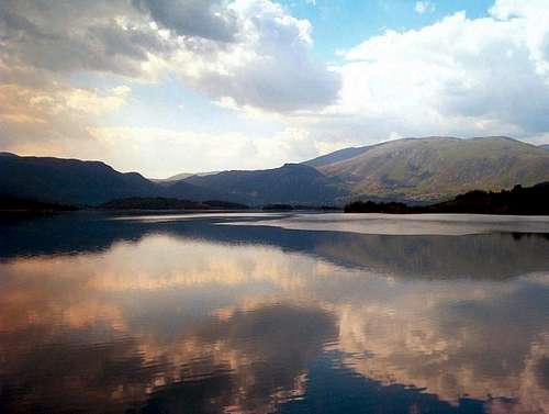
Radusa - view  accross the  Rama lake

...mt. Radusa is one of those not particulary high mountains
that sometimes attract our interest because of the surroundings,  rather then striking geological features.
By the geological structure, it is  part of the internal Dinarides.
Together with mountains Vran, Ljubusa, Vranica mountain group (Vranica, Stit & Bitovnja), Bjelasnica,
Treskavica, Zelengora and Maglic ,  Radusa creates natural border between forrest and fertile ground rich
Bosnia on the north, and  rocky, harsh karst environment enhanced Herzegovina on the south.
Boundaries: Vukovsko polje on the north, Zahum pass (1224m/4015f)
and Rama basin with large man made lake on the south, mt. Stozer(1758m/5766f) on the east,
 Makljen pass(1123m/3683f) on the west. Makljen pass is connection between Vrbas river valley
and Neretva river valley. Nearest town is Prozor on the east., Tomislavgrad (ex Duvno) on the west.
Ascending: Common ascent is from Zahum pass over the southern slopes to Idovac (highest peak of Mt. Radusa)
Elevation gain:  732m/2401f
Time required: roughly 3 hours
From the Zahum pass, hit uphill north through the Zahum village.
After leaving the village, follow the - at the time of visit poorly marked - trail up the southern slope (not too steep,
mixed grass/rough grazing with small crags and rocks). Inside hour of walk, you will reach pastures and meadows rich
area and perhaps  a herd or two and some sheppards enroute. If no sheppards, pay some attention to sheppard dogs
(local breed, named tornjak) and stay at reasonable and common sence driven distance both from the dog and the herd.
Near the Radusa kamen peak (1664m/5458f), trail enters then leaves the small woods, catching with the upper meadows again.
As you reach the highest point of the mountain, trail will continue toward the lake (cca 1850m altitude), leave the trail and continue
uphill to the main summit. Once you have noticed collapsed concrete pillar with name "Idovac" and altitude "1956" indicated,
this is it. Now , one may enjoy the views.
The views: The cone shaped Idovac is the highest peak mt Radusa and, arguably, top lookout summit in central Bosnia.
Southbound, vista stretches accross the undulated mt. Ljubusa towards mt. Cvrsnica and mt. Vran.
Deep down is what once was the Rama river valley. Rama river is the western tributary of the Neretva  river.
It  was dammed after WWII, flooding the walley, but not the hills in the valley. They still peak out of the water.
Those small islands, together with the newly formed small gulfs, make Rama lake one of the most scenic man made lakes of Southeast Europe
(285km long Neretva is the only Bosnian river flowing into the Adriatic sea,
 it is well known for its gorge between mt. Cvrsnica and mt. Prenj).
Vranica group of mountains entertain our views on the east, whilst on the west side, view stretches accross the so called Trium camporum,
Kupresko polje, Glamocko polje and Livanjsko polje, the largest polje district of the entire Dinarides, stretching SW->NE between Dinara massif
and Kupres pass.
(Polje is one of the key ladforms of the limestone Dinaric mountains, large deppression
formed as a result of collapsing underground caves and caverns. Overall number of poljes in Dinarides mountains exceed 100,
 Livanjsko polje being the largest one). 
On  the way back from the summit, you  can visit the small lake.
 Nothing spectacular, more like pond. Still, it is the highest lake of Bosnia & Herzegovina.


Bits on history

- First traces of human life in the area were found at th foothil of mt Radusa, near the Rama river source
  and they are dating back to the Paleolitic. Remains of  settlements dating from the Illyrian and Roman times have also been found...
- This area was also the heart of the early Bosnian medieaval state ...
-Some of the trails on mt. Radusa are actually the old "tobacco trails", routes used in the past by smugglers smuggling tobacco
  from Herzegovina to the North...
-  During the Second World  War, early year 1943., Yugoslav resistance forces ("partizani") have undertaken a breaktrough down the Rama river
  valley, aiming to cross the Sarajevo-Mostar railway line. Mt. Radusa was used as observation  point enroute. What had followed, was the largest
  frontal battle on the Balkans during the WWII, between partisans at one, and combined German/Italian/Ustasa/Chetnik forces at the other side.
  Movie about the whole event was filmed in late 1960s, titled "The Neretva battle".
  Actually, the movie was nominated for Oscar award, but did not make it.
  Some may still remember it, though, because of the famous Orson Wells stunt...
- In early 1970s, group of Croat uprisers (later known as "the Bugojno group" )
  crossed illegally the Austrian/Yugoslav (now Austrian/Slovenian) border.
  What had followed was wierd and wild one month chase, involving 30000 strong combined police and military forces.
  Group was finally nailed down whole month later on  Mt. Radusa. There were casualties on both sides.
 Short therm effect was Radusa making the news headlines.
  Long term effect, however,was complete change in Yugoslav defence doctrine and switching to the "territorial defence" (teritorijalna obrana),
  with ubiqous NNNI (Nothing should catch us by surprise) drills...
- In 1980s Rama lake became popular chillout destination among  painters and art photographers alike. Motifs of  the lake topped by mt. Radusa
  appeared on several art exhibitions...


Getting There

Nearest intl airport is  the Sarajevo airport
By car: From Sarajevo (the Bosnian capital)
drive east  the Konjic-Jablanica road next to the Jablanicko lake.
At Jablanica, turn right for Bugojno and drive till Prozor. At Prozor,
turn left for Rumboci and hit the old Prozor-Tomislavgrad(ex Duvno) road.
It is about 1 hour drive from Prozor to Zahum pass (start of the trail), last part of it unsurfaced
road with rocks and small boulders around it. Good 4x4 recommended. One may drive opposite
direction, from Tomislavgrad as well, you are likely to use this option if coming from south (Dalmatia).
Again, careful driving recommended.
From north ; E661 Banja Luka-Jajce-Bugojno-Prozor;  150km.

Weather, Gear, Camping

Weather: nearest weather station is in town Bugojno, some 18km north of mt. Radusa.
http://www.fmzbih.co.ba/prognoza-bugojno.php
In English ( from the drop-down list pick Bugojno, then click "Submit" button)

Gear: hiking gear, kompass, tent and camping gear if you plan to camp

Camping: no camping grounds nearby, as  far as one may remember. Camping is not prohibited, however,
you may wish to talk with villagers at Zahum village first for more info. Other options are to base yourself
on the plateau above the Rama lake, or negotiate for accomodation with people living down next to the lake.

It may be that there is some dedicated camping  place next to the Rama lake. In fairness, I just do not remember one

Tongue twisting

Radusa is written with caron atop of the "s" letter
and should be pronounced "Radooshah"


Parents 

Parents

Parents refers to a larger category under which an object falls. For example, theAconcagua mountain page has the 'Aconcagua Group' and the 'Seven Summits' asparents and is a parent itself to many routes, photos, and Trip Reports.

Dinaric AlpsMountains & Rocks