
-
 20967 Hits
-
 90.13% Score
-
 31 Votes
|
|
Area/Range |
|---|---|
|
|
46.71915°N / 10.34363°E |
|
|
Hiking, Mountaineering, Scrambling, Skiing |
|
|
Spring, Summer, Fall, Winter |
|
|
10512 ft / 3204 m |
|
|
1 - Overview
The Sesvenna group – named after its highest summit – is located at the centre of the Rhaetian Alps, which themselves are located at the centre of the Alps. It is a remote region three quarter of which are on Swiss ground while the remaining quarter belongs to Italy. A tiny fraction of the group – with no summits in it – is located on Austrian ground. The “three-countries-corner” can be found a couple of hundred meters north of Piz Lad, the northernmost summit of the group. As is quite common with these remote areas – the Sesvenna Group is relatively unknown. While its east looms above one of the major north-south throughways, the Reschenpass Road it is eclipsed by its far more impressive neighbours, the Ötztal Alps to the east, the Ortler/Cevedale Group to the south and the Silvretta Group to the north. Other neighbours are the Albula and Livigno Alps to the south-east. The eastern (Swiss) part of the group is even more remote but every single summit offers perfect views to the mountains around.The Sesvenna Group is formed like an odd triangle with the tips to the west, north-east and south-east. It is bounded by Unterengadin to the north, upper Vinschgau / Val Venosta to the east and Münstertal / Val Müstair to the south. The mountains surround a high plateau in their midst, the pastures of S-Charl, very remote and very tranquil. There are lots of passes between the summits which subdivide the group into 9 subgroups, -ridges and -ranges. The passes have been used for at least a thousand years. The name S-Charl stems from Charlemagne, who travelled through the region on his way from his northern empire to Lombardia. There are quite a number of buildings and artefacts dating back to that time. The monastery of Müstair, for example, is reported to have been founded by Charlemagne. It gave the name for the whole valley south of the Sesvenna Group. Today, the most important pass is Reschenpass to the north-east of the group, but Finstermünzpass and Ofenpass to the north and south are also of (though lesser) importance.
The mountains are not overly high or impressive. Still you can find 34 named 3000ers, not to count the unnamed false and side summits. Piz Sesvenna is the highest mountain of the group and as such one of the more popular summits, quite naturally. The Sesvenna Group is well known for its tour skiing possibilities. Many of the summits east of the S-Charl Valley are popular destinations. Beside Piz Sesvenna, Piz Lad, Piz Rasass and Schadler are among the more popular ones. There is only one glacier in the group, the Vati da Sesvenna, a small permanent snowfield to the north of Piz Sesvenna. All the other glaciers have vanished, thanks mainly to the rock composition – which is limestone and dolomite.
Like with its neighbours to the north and east, the Samnaun and Raetikon Groups, the Sesvenna Group belongs to the heart of the Rhaeto-Romanic speaking area. While in other regions the language has made way for the one of newcomers – German and Italian – here in the remote heart of the Rhaetic Alps it still can be found. Most of the names of villages and mountains are of Rhaeto-Romanic origin and only in the easternmost part of the group will you find two or three different names for any given summit.
2 - Panorama pictures
WatlesVernunspitzeOrtler / OrtlesKälberberg / M. dei VitelliMuntpitschenPiz SesvennaPiz PlazerPiz RimsPiz CristanasPiz d'ImmezPiz LischanaCraist'AltaPiz S-ChalambertGriankopfElferspitzeSeebodenspitzeWeißkugel
 |  |  |  |  |  |  |  |  |  |
www.seilschaft.it hosts a number of beautiful 360° panoramas from the summits of the Sesvenna Group. Pending the permission to directly link one from the site I want to direct you to them from the listing below. The last panorama (the one from Schadler) is taken from the homepage of the Sesvenna Hut.
3 - The Sesvenna Group on SP
|
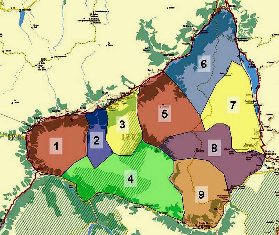

- Piz Macun Group
- Piz Nair Ridge
- Piz Pisoc Group
- Sampuoir / Tarvü Ridge
- Piz Madlein Group
- Rusenna Group
- Seeboden Group
- Sesvenna / Greppi Ridge
- Piz Starlex Group
4 - Piz Macun Group
The Piz Macun Group is the westernmost of the subgroups of the Sesvenna Range. It takes up the westernmost tip of the triangle which forms the whole group. Piz Macun is located on a ridge at the centre of the group, which is formed like a horseshoe, open to the north. The easiest access routes are from Lavin in the north and Zernez in the south-west. The boundary to the neighbouring Piz Nair group is Val Sampuoir. The highest mountain is Piz Nuna in the south-east of the range.- Piz Mezdi (2927m)
- Piz d’Arpiglias (3027m)
- Piz Sursassa (2968m)
- Spi da Laschadura (2974m, 3001m, 2935m)
- Piz Macun (2889m)
- Piz Giarsinom (2631m)
- Piz Nuna (3123m)
![]()
- Ils Cuogns (2838m, 2896m, 2792m)
- Piz Sursass (2910m)

5 - Piz Nair Ridge
Between Val Samuoir and Val Plavna you can find the single ridge around Piz Nair. The group is small, the ridge running from north to south. The southern boundary towards the large Sampuoir / Tarvü Ridge is Forca Pedrus. The easiest accss routes start from Ardez and Tarasp in the north, running along the two bounding valleys. The highest summit of the group, Piz Plavna Dadaint, is located at the south of the ridge.- Crap Putèr (2363m)
- Piz Nair (2951m)
- Piz Pallas (2922m, 3031m)
- Piz Plavna Dadaint (3166m)
6 - Piz Pisoc Group
 Piz Picoc Group seen from Scuol
Piz Pisoc is located at the centre of an impressive group, which is located between Val Plavna in the west, Val S-Charl to the east and Val Minger to the south. The southern boundary to the long Sampuoir / Tarvü Ridge is the pass Sur ‘il Foss. In the north of the group you find three north-south ridges which combine near Piz da la Crappa to form a single ridge southwards to Sur ‘il Foss. The peaks at the centre of this group are all 3000ers, all showing impressive faces into the valleys below. The highest summit is Piz Pisoc itself.
- Piz Plavna-Dadora (2961m)
- Piz Mezdi (2727m)
- Piz Zuort (3119m)
- Piz Lavetscha (2790m)
- Piz Clemgia (3042m)
- Piz Pisoc (3172m)
- Piz da la Crappa (3122m)
- Piz Minger (3081m)
- Piz dals Cotschens (3057m)
7 - Sampuoir / Tarvü Ridge
The ridge runs along two thirds of the southern side of the Samnaun Group triangle. It runs roughly WNW to ESE but on its eastern side does a couple of S-shaped bends. There are several side ridges to either side (two to north, two to the south) but all main summits are located on the main ridge. The southern boundary is the idyllic Münstertal Valley, which also is the best starting point for any route onto the ridge. The northeastern part of the group can be reached from S—Charl in the dead centre of the Samnaun Group. The highest mountain of this subrange is Piz Tarvü.- Piz Ivraina (2886m)
- Piz Laschadurella (3003m)
- Piz Ftur (3022m)
- Piz Sampuoir (3023m)
- Piz Murters (3012m)
- Piz dal Fuorn (2903m)
- Piz Nair (3009m)
- Piz Foraz (3092m)
- Mot Foraz (2429m)
- Piz Nüglia (2995m)
- Mot Tarvü (2420m)
- Piz Tarvü (3168m)
- Piz Vallatscha (3021m)
- Munt da Bescha (2693m, 2772m)
- Piz d’Astras (2980m)
- Piz Mezdi (2883m)
- Mot dal Gajer (2796m)
- Mot Mezdi (2492m)
8 - Piz Madlein Group
 The Piz Madlein Group seen from S-Charljoch
The group is composed of several short ridges which run from all directions into a cirque in its centre. The cirque is filled with about a dozen beautiful lakes and dominated by the (otherwise rather insignificant) Piz Curtinatsch (2866m). The boundaries of the group are Val S-Charl to the west and south and Val d’Uina to the east. Starting points for the exploration of the group are Scuol and Ramosch in the north and S-Charl to the south. The highest summit is Piz Madlein to the south-west of the group.
- Mot Radond (2375m)
- Piz Rims (2772m)
- Mot (2285m)
- Piz Ajü (2778m)
- Piz Triazza (3043m)
- Piz Lischana (3105m)
![]()
- Mot Lischana (2457m)
- Mot S. Jon (2442m)
- Piz S. Jon Dadora (3048m)
- Piz S. Jon Dadaint (3093m)
- Mot da la Sellas (2604m)
- Piz Pradatsch (2600m)
- Piz Madlein (3098m)
- Piz Cotschen (3046m)
- Piz 2902 (2902m)
- Piz d’Immez (3026m)
![]()
- Piz Cornet (2971m)
- Piz Cristanas (3091m)
- Piz Rims (3050m)
![]()
- Schadler (2948m)
![]()


9 - Rusenna Group
The Rusenna Group is located at the northernmost tip of the Sesvenna Group triangle. It also is home to the point, where the three countries Austria, Italy and Switzerland meet, just 100m north of Piz Lad. The group itself is a single rigde, bounded by the upper Inn valley to the north-west and the Etsch / Adige Valley to the east. The ridge constitutes the boundary between Switzerland and Italy, resulting in several names for many of the summits, Rhaetian, Italian and German ones. The northernmost point is the road climbing up to Nauders, the southernmost point is Rasass Pass, which separates the Piz Madlein, Rusenna, Seeboden and Sesvenna subgroups. The Rusenna Group is famous for its views towards the surrounding mountain ranges and its northern part offers a good view towards Reschensee in its east. The highest mountain - and the only one to surmount 3000m - is Piz S-Chalambert Dadaint (3031m). It is located on the only side ridge the subgroup has.- Piz Lad (2807m)
![]()
- Piz Nair (2743m)
![]()
- Piz Ajüx (2755m)
- Piz Rusenna / Jochbodenkopf (2802m)
![]()
- Dosso di Fuori /Äußerer Nockenkopf (2770m)
- Spi da Rusenna (2693m, 2741m, 2707m)
- Dosso di Dentro / Innerer Nockenkopf (2772m)
- Piz S-Chalambert-Dadaint (3031m)
- Piz S-Chalambert-Dadora (2678m)
- Cima di Vallunga / Fallungspitze (2643m)
- Piz Mezdi (2542m)
- Griankopf (2896m)
- Piz da Gliasen (2468m)


10 - Seeboden Group
This is the easternmost subgroup of the Sesvenna Group. Again it is a single ridge, running north to south with a couple of deviations in the south. The group does not reach 3000m and is thus unique among the Sesvenna Subgroups. However, its highest summits, Elferspitze, Seebodenspitze and Rasass-Spitze are perfect lookout summits: easy to reach with an impressive panorama to all sides. The boundaries of the group are the Etsch / Adige Valley to the east, the Vallunga Valley to the north and west and Valle di Slingia / Schlinigertal to the south. The highest summit is Rasass-Spitze at 2941m.- Cima Dieci / Zehnerkopf (2675m)
![]()
- Cima Dodici / Zwölferkopf (2783m)
- Cima Undici / Elferspitze (2926m)
![]()
- Cima Pian del Lago Nord (2832m)
- Cima Pian del Lago / Seebodenspitze (2859m)
- Dosso Nero / Schwarzerkopf (2722m)
- Rasass-Spitze (2941m)
![]()
- Vernùn / Vernungspitze (2818m)
- Monte Vatles / Watles (2555m)


11 - Sesvenna - Greppi Ridge
The ridge around the highest mountain of the Sesvenna Group runs from WNW to ESE culminating in the four summits of Piz Plazer, Piz Sesvenna, Muntpitschen, Cima Valdassa, the only three summits to cross the 3000m boundary. The group is wedged between two groups of valleys and their passes, Valle Sesvenna / Valle di Slingia with Forca Sesvenna in the north and Val Plazer / Val d’Avigna with S-Charlsjoch to the south. The group can be best reached from the east and south.- Mot da l’Hom (2758m)
- Piz Plazer (3104m)
- Piz Sesvenna (3204m)
![]()
- Foratrida (3136m)
- Monpiccio / Muntpitschen (3162m)
- Punta della Vedretta / Fernerspitz (2954m)
![]()
- Föllakopf (2890m)
- Punta Erosa (2530m)
- Monte die Vitelli / Kälberspitzen (2736m)
- Monte die Vitelli (2736m)
- Cima Valdassa (3049m)
- Costeras (2946m)
- Cima d’Arunda (2879m)
- Cima di Greppi (2720m)
- Cima di Tella (2527m)


12 - Piz Starlex Group
Located at the southern tip of the Sesvenna Group triangle, the Piz Starlex Group is a single Ridge located between Val d’Avigna and the Clengia / Laider Valleys. The Italian - Swiss border runs along the ridge, starting at S-Charlsjoch in the north and ending between Taufers and Müstair in the south. Piz Starlex and Monte San Lorenzo are the only summits which surmount the 3000m boundary.- Mot Falcain (2690m)
- Monte San Lorenzo (3021m)
![]()
- Piz Murtera (2969m)
- Piz Starlex (3075m)
![]()
- Piz Cotschen (2768m)
- Piz Terza / Urtirolaspitz (2909m)
![]()


13 - Getting There
The nearest international airports are Innsbruck in Austria, Milano and Verona in Italy and Zürich in Switzerland, though only Innsbruck is real close by. Consequently the itineraries from the other airports are far more lengthy and complicated.- From Innsbruck
Simply take motorway A12/E60 west towards Landeck. There take B184 towards Reschenpass. At Nauders you can turn onto B27 into Unterengadin / Switzerland for the northern part of the Sesvenna Group. Alternatively take B180 / SS40 which will take you to the eastern part. At Schluderns /Sluderno you can turn westward onto SS41/B28 for Val Müstair and the southern part of the Sesvenna Group.
- From Zürich
Take motorway A3 east to Vaduz. At exit Bad Ragaz take B28 to Davos and across Füelapass to Susch. Here turn on B27 north for the northern part or B28 east for the southern part of the Sesvenna Group.
- From Milano
Take the ring motorway north and leave for SS36 north. It will take you by Monza and Lago di Como until you reach Chiavenna. There turn Onto SS37 east in direction of St. Moritz. The road turns into B27 on the Swiss side of the border and takes you on to Susch, where you can decide between B27 and B28 for the northern or southern parts of the groups respectively.
- From Verona
Take Motorway A22 (Brenner Motorway northward until you reach Bozen / Bolzano. There turn onto SS38, Vinschgauer Staatsstrasse, which takes you to Schluderns / Sluderno. Take SS40 for the eastern part of the group or B41 / B28 for the southern one.
14 - Red Tape
The Swiss part of the group is a National Park. The usual rules apply - leave plants and animals, take your refuse, keep dogs on leash etc. Also, you are in the border region between three European countries and though Italy and Austria belong to the EU, Switzerland doesn’t. Keep your Pass or ID handy.14 - Mountain Huts & Refuges
There are only two handful of huts in the Sesvenna Group, though there are quite a number of Alms where you might be able to find shelter from the weather. The following table gives an overview of the huts.| Refuge / Hut | Height | Summer | Winter | Tel. | Thumbnails |
| Haider Alm | 2120m | end June - end Sept. | mid Dec. - mid April | +39/0473/634628 | |
| Lischanahütte | 2500m | beg. July - beg. Oct. | closed | +41/81/8649544 |  |
| Rojenskihütte | 2006 | all summer | all winter | +39/336/521992 | |
| Schönebenhütte | 2100m | end June - end Sept. | mid Dec - end April | +39/0473/633333 | |
| Sesvennahütte | 2256m | mid June - end Oct. | end Feb. - mid May | +39/0473/830234 |  |
15 - Accommodation
15.1 - Austria
15.2 - Italy
15.3 - Switzerland

16 - Weather Conditions
In addition to the weather information on the sites you find under accommodation you can look up these sites:17 - Maps & Books
17.1 - Maps
- Digital Maps
- www.swissgeo.ch
- Vinschgau / Val Venosta
Kompass GPS Map GPS 4052
ISBN: 3-85491-659-0
- www.swissgeo.ch
- Regular Maps
- Vinschgau / Val Venosta
Kompass Map WK 52
1:50.000
ISBN: 3-85491-058-4
- Unterengadin-Nationalpark
Kompass Map WK 98
1:50.000
ISBN: 3-85491-331-1
> - Obervinschgau / Alta Val Venosta
Kompass Map WK 041
1:25.000
ISBN: 3-85491-580-2
- Schweizer Landeskarten, available at German Alpine Club
- SLK 259 S Ofenpass, 1:50000, Art.Nr.: 147259
- SLK 1219 S-charl, 1:25000, Art.Nr.: 141219
- SLK 259 S Ofenpass, 1:50000, Art.Nr.: 147259
- Vinschgau / Val Venosta
17.2 - Books
- Vinschgau-Ortlergruppe
Kompass Guidebook WF950
Kompass Verlag
ISBN: 3-85491-404-0
- Unterengadin
Rudolf Weiss / Siegrun Weiss
Rother Verlag
ISBN: 3-7633-4043-2
- Vinschgau
Henriette Klier
Rother Verlag
ISBN: 3-7633-4205-2