
-
 43252 Hits
-
 94.02% Score
-
 45 Votes
|
|
Area/Range |
|---|---|
|
|
46.38069°N / 9.90692°E |
|
|
Hiking, Mountaineering, Trad Climbing |
|
|
Spring, Summer |
|
|
13291 ft / 4051 m |
|
|
a small preliminary remark ...
the goal of this page is to introduce some starting knowledge of this very fine group, one of the best in the Alps, joining the peaceful southern valley, full of flora, with the wild high walls rarely climbed (only 2 routes on Piz Bernina and the 3 spurs and the normal route of Piz Palù are often climbed)3 big important glaciers give to this area a real appearence of "high mountain environment"
On Italian side you can find some, sometimes busy, refuges where food is always a good reason to make a stop
On Swiss side you can enjoy a "fin de siecle" trip using the carriage bringing, along the Val Roseg, toward the fine meadows under the glacier ..
Here you will find only the main geographic and logistic info: the complete description of the summits should belong only to summit pages
|
|
|

|

Val Roseg panorama near Hotel Roseg
Overview
Bernina Group belongs to Alpi Retiche Occidentali (Raethian Western Alps)It stands on the main watershed of the Alps, oriented W-E, starts from the Passo del Muretto (2562m), Eastern limit of Val Masino Alps) and ends to the Bernina Pass (2304m).
This group hosts some important glaciers and the highest summits east of Pennine Alps.
Geologically speaking the area is made of rocks of Permian-Carboniferous Era, hosting thick layers of Granites, Diorites and Syenites that can give a climber the pleasure of solid and coarse rock.
this group is all made for old style classic climbing, differences in elevation are never small, no roads, no comfortable accesses, no modern routes ...
It can be defined in 3 different sections + 1 subgroup :

Map

Western range
starting from passo del Muretto and ending with the Passo Scerscenthis ridge is the Northern border of the basin of Chiesa Valmalenco and Caspoggio
main ridge
between the Val Malenco (S) and the Val Fedoz and Val Fex (N)
immediately over the Passo del Muretto the ridge grows with the :
secondary ridges
between the Val Forno and the Val Fedoz
from Monte Muretto to the north, starts the Piz da la Margna ridge hosting, from S to N, the
between the Val Fedoz and the Val Fex
from Sassa di Fora to the north a ridge hosting 2 fine summits :
between the Val Malenco and the Scerscen glacier
from Pizzo delle Tre Mogge to the East a ridge with 2 first noticeable summmits :
 from left Sassa d'Entova, Pizzo Malenco, Pizzo Tre Mogge (the photo has been shot from Bocchetta delle Forbici (East)
this ridge goes down with the Sasso Nero (2921m) to the Monte Motta (2336) whose S slopes host the higher part of the skiarea of Chiesa Valmalenco
Central range
after the Passo Scerscen (wherefrom spreading, toward east, the first important glacier of the south side of the group : the Ghiacciaio di Scerscen, many years ago there was a summer ski area now abandoned ...) the main ridge grows with a very fine sequence of summits characterized by rocky steep walls to the South and shining ice slopes on their northern sidemain ridge
between the Scerscen glacier (S). the Val Roseg and the Val Morteratsch (N)
 the rocky south big wall of Glüschaint subgroup seen from forcella d'Entova
these are, from W to E :
this ridge, also known as Glüschaint subgroup, ends to the Passo Sella (3268m)
 the south side of the Glüschaint subgroup, the Sella pass and the Piz Roseg
the Passo Sella is the starting point of the high ridge hosting the 3 giants of this area :
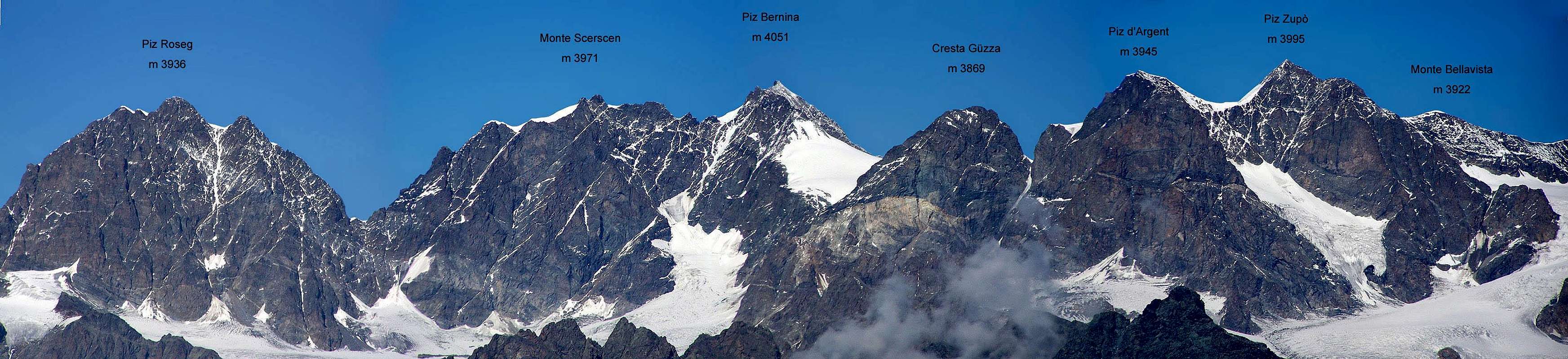
 the huge south walls of Piz Roseg and Monte Scerscen
the cross of these 3 summits, from W to E, along the ridge, is one of the most demanding climb in the whole Alps
 the Crast'Alva (Biancograt), Monte Scerscen and Piz Roseg north walls from the summit of Piz Morteratsch
 Costa di Fortezza, Piz Bernina, Piz Prievlus, Piz Morteratsch and Piz Tschierva from the Morteratsch glacier, little below the Diavolezza
the ridge now goes down, toward south to the Forcola di Cresta Güzza
secondary ridges
between the Val Fex and the Val Roseg
from Glüschaint toward N an important ridge, starting with the Chapütschin (3386m) and going down with a sequence of minor summits, ending with the Piz Corvatsch (3451m), famous skiarea of Saint Moritz
between the Val Roseg and the Val Morteratsch
from Pizzo Bernina toward north starts an important ridge hosting, in sequence, the
 a view from South
then the ridge becomes less important hosting some minor summits :
Eastern range
... and the giants go on ...main ridge
between the Val Morteratsch (N) and the Val Lanterna (S)
starting with
east of Piz d'Argent the second summit of the Group, the
 a view from Boval Hutte
 Piz Palù and Bellavista from Bovalhutte
after these summits there is the starting point of one of the most famous subgroup of the Alps : the Palù subgroup whose summits are :
 Piz Palù from Diavolezza
 from left Cime di Musella (western-Central-Eastern)- Torrione Brasile - Cima di Caspoggio
secondary ridges
between the Scerscen and the Fellaria glaciers
from Piz d'Argent a smart ridge goes down toward south, hosting some fine rocky summits :
and the 3 fine summits called Cime di Musella (3079-3088-3094m)
the ridge ends with the Monte delle Forbici (2910m)
 the NW side of the Cime di Musella, on the left side the Vedretta di Caspoggio
 the Pizzo Scalino subgroup
between the Morteratsch glacier, the Palù glacier and the Bernina valley
from Piz Palù, in all the directions, the ridges go down hosting only minor summits with low importance
Scalino subgroup
bordered by Val Poschiavina, Val Malenco, Val Lanterna and Val di Campo Moro, this subgroup (not a simple ridge) starts from passo di Canciano (2454m) and immediatly grows to the main summit[img:175312:aligncenter:medium:the Pizzo Scalino subgroup]
from this summit 3 ridges go :
toward SW - the ridge of Acquanera
toward S - the ridge of Painale - Vetta di Ron
toward SE - the ridge of Sareggio - Combolo
these ridges, ending to the bottom of Valtellina, are made of very wild and forgotten summits : the differences in elevations are high and paths are missing.
Logistical Info
Two main accesses to this area :from ITALY - Valtellina
the road from Sondrio to Chiesa Valmalenco brings you in the center of the group and there you have 2 different choices :
for the Western range follow the road toward Chiareggio
along this road there are the starting point for :
for the Central range follow the road for Campo Moro
near the dam of Campo Moro the starting point of the paths to
for the Eastern range follow the road for Campo Moro
near the dam of Campo Moro the starting point of the paths to
from SWITZERLAND - Engadina
along the road joining Bernina Pass-Saint Moritz-Maloja pass the accesses to the valley entering in the N side of the group
for the Western range
from Sils the cablecar to Piz Corvatsch or directly to the summits
for the Central range
starting from Pontresina and walking along the Val Roseg to get the
starting from the rail station of Morteratsch, along the Val Morteratsch, to get the
for the Eastern range
starting from the rail station of Morteratsch, along the Val Morteratsch, to get the
starting about 5 km before (arriving from CH) or beyond (arriving from I) the cable car to
Meteo
| Weather Chiesa in Valmalenco - Free service by Weather Webcam |