
-
 7626 Hits
-
 87.31% Score
-
 24 Votes
|
|
Mountain/Rock |
|---|---|
|
|
46.77632°N / 10.48754°E |
|
|
Hiking, Skiing |
|
|
Spring, Summer, Fall, Winter |
|
|
9600 ft / 2926 m |
|
|
Overview
 Elferspitz above Reschensee as seen from Reschner Alm Elferspitz above Reschensee as seen from Reschner Alm |
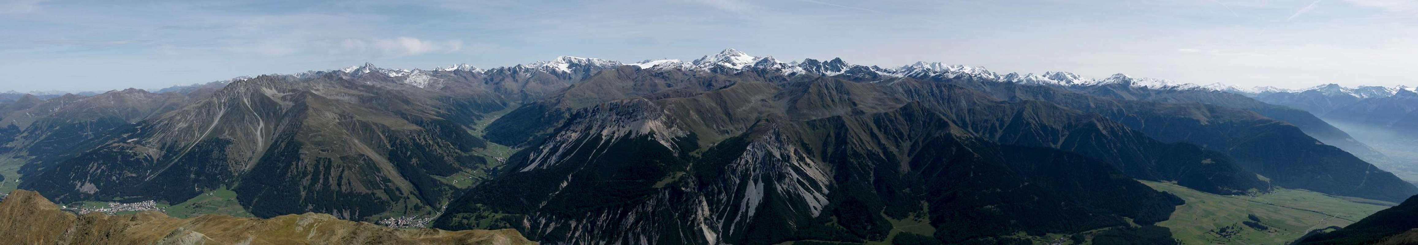
Elferspitz / Cima Undici is the highest summit of the Seeboden subgroup of the Sesvenna Group. Together with Zehnerkopf / Cima Dieci and Zwölferkopf / Cima Dodici it forms the central part of the sundial of the hamlet of Rojen in upper Vinschgau / Val Venosta. Thanks to the fact, that the neighbouring Rusenna Group also is lower in its entirety, Elferspitz is one of the best lookout spots in the whole area. Consequently it is very popular and there'll be quite a lot of traffic on the southern ascent route, which runs through the Haiderscharte Saddle. The northern route is less popular since part of it is hidden between Grubenkopf and Zehnerkopf and since the north face of Elferspitz / Cima Dieci is very steep but brittle.
 E E |  SE SE |  N N |
The popularity of this near-3000er is due to the fact that two lifts lead up to its base so that the first 500m can be skipped. Moreover these lifts are connected by a panoramic trail, one of the most popular of the region, which offers perfect views across Reschensee / Lago di Resia towards the Ötztal Allps in the east. Both routes are far from difficult but deter some would-be ascensionists with their exposure on brittle rock.
 Piz S-Chalambert Dadaint, Fluchthorn Piz S-Chalambert Dadaint, Fluchthorn |  Alt Graun Steeple Alt Graun Steeple |  Muttler Muttler |
In winter, Elferspitz / Cima Undici is a very popular ski tour, often done in conjunction with a traverse of the whole Seeboden Ridge.
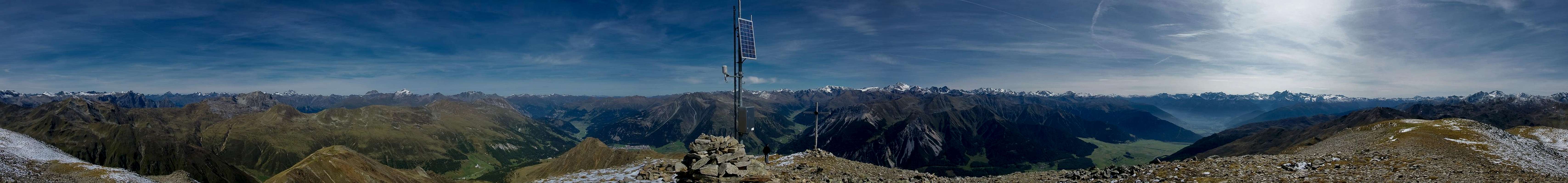
360° summit panorama
  |
Getting There
 |
Elferspitz/ Cima Undici is easy to reach. Just head for Reschenpass / Passo di Resia and in the village of Reschen / Resia follow the signs to the Schöneben / Bellpiano ski area. In winter you can use the chair lift to get to the base of Zehnerkopf, in summer you need to drive to the village of Rojen or (technically not allowed) to the top station of the chair lift. There is ample parking space though it might be crowded anyway, depending on the season.
An alternative is the cable-car, which runs from St. Valentin / San Valentino (Some 2km south of Reschensee) to Haider Alm. Both lift stations (Schöneben and Haideralm) are connected by a panoramic trail from which the ascent routes to Elferspitz turn off.
Red Tape
 Elferspitz / Cima Undici as seen from Reschner Alm
There is no red tape to speak of. As indicated in the Getting There section, the road to the top station of the Schöneben chairlift is closed, though the gates are open for most times of the year.
Accommodation
- Nauders Accommodation
- Vinschgau / Val Venosta Accommodation
- Reschenpass / Passo di Resia Accommodation
Weather Conditions
 Elferspitz / Cima Undici as seen from Hochjoch / Giogo Alto
Maps & Books
Maps
- Vinschgau / Val Venosta
Kompass Map WK52
1:50000
ISBN: 978-3-85491-058-9
- Alta Val Venosta / Vinschgauer Oberland
Tabacco Map 43
1:25000
Books
- Vinschgau
Rother Wanderführer
Rother Verlag
ISBN: 978-3-7633-4204-1
- Vinschgau / Ortlergruppe
Kompass Wanderbuch 950
Kompass Verlag
ISBN: 3-87051-404-3