
-
 1931 Hits
-
 80.49% Score
-
 12 Votes
|
|
Mountain/Rock |
|---|---|
|
|
39.47121°N / 8.71407°E |
|
|
Sardinia |
|
|
Hiking, Scrambling |
|
|
Spring, Fall, Winter |
|
|
3356 ft / 1023 m |
|
|
Overview
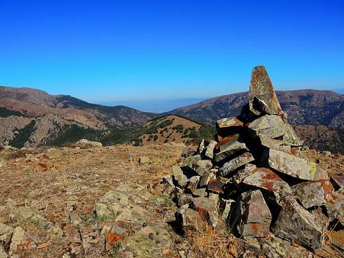
Punta Magusu 1023 m
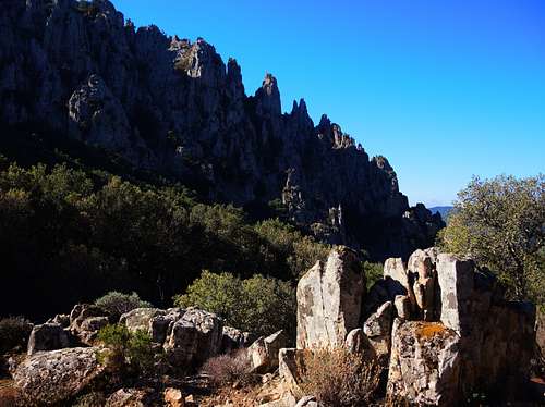
Punta Magusu 1012 m is a mountain belonging to the Linas massif and located in South West Sardinia. Although not one of the main peaks of the massif, it's a very attractive mountain, particularly wild and secluded and showing very steep rocky sides.
The itinerary to summit the mountain starting from the Cantina Ferraris is a no technical route and doesn't oppose particular difficulties. You need to do just an easy scrambling to overcome some easy rocky stretches in the last part of the itinerary. Anyhow it should be remembered that the route follows a wild path not always easy to find.
Getting There
Sardinia, the Westernmost region of Italy, can be reached by plane, otherwise by ferry-boat from Livorno, Civitavecchia and Genova harbors. The nearest town to climb Punta Magusu is the village of Villacidro, South Sardinia.

Road approach
From Villasor drive along the State Road 196 towards Villacidro. At the first houses of the village turn left following the "Montimannu" signposts and drive on a paved road reaching a fork after 2 km. Turn to right and pass the dam on the Lago di Montimannu, then drive along the Northern shore of the lake and cross a bridge over the creek Bidda Scema. After the bridge the road heads to left and skirts the lake again for about 4 km. getting a second bridge over the creek Leni. After this second bridge the road heads to right and continues for about 5 km more reaching the Caserma Forestale di Montimannu. Driving again for about 1 km. you reach a large esplanade near the beautiful Cantina Ferraris at an altitude of 367 m, where you park the car.
Route
Monte Magusu Normal route
Difficulty: EE - Some easy rock climb up to I UIAA near the summit
Difference in level: 660 m
Starting point: Cantina Ferraris 367 m
A very profitable route in a wild environment, requiring intuition to follow the correct itinerary
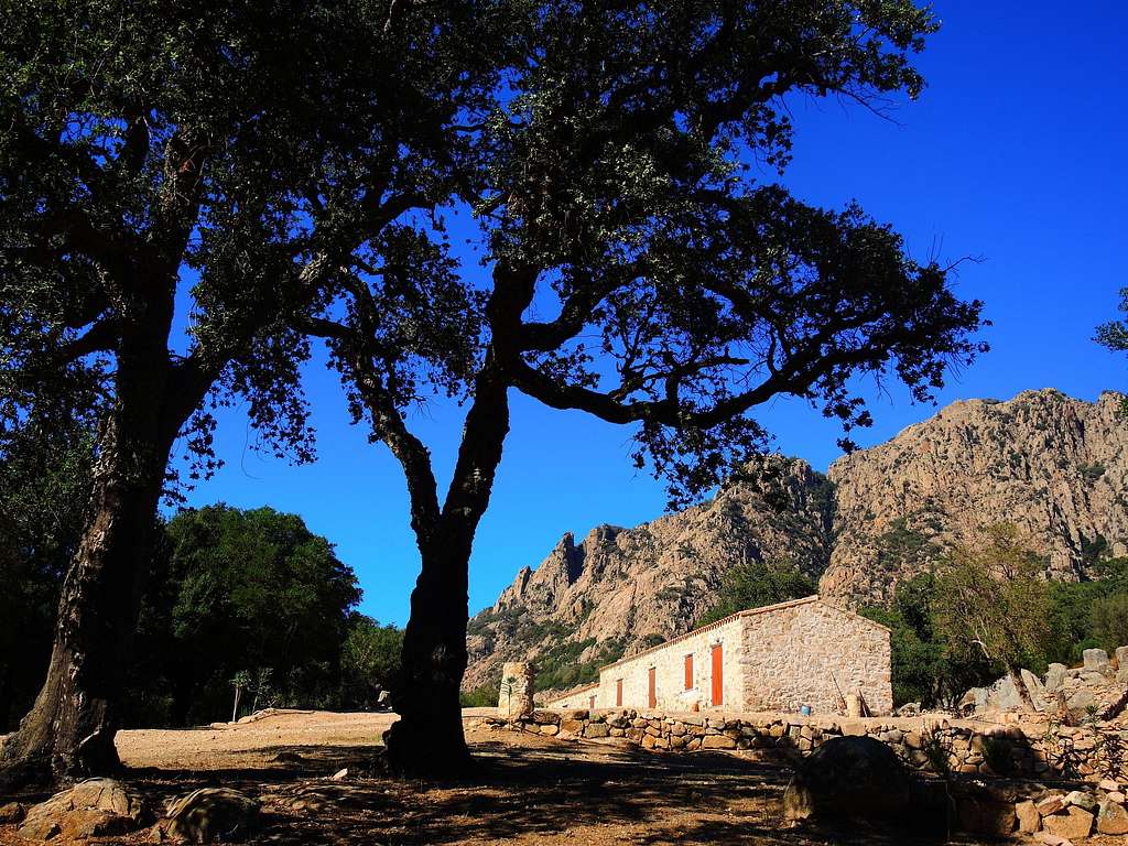
Parked the car near the beautiful farm called Cantina Ferraris, a peaceful site among huge holm oaks (source), briefly descend back to the dirt road and continue rightward walking on the road that runs along the left orographic side of the Cannisoni stream.
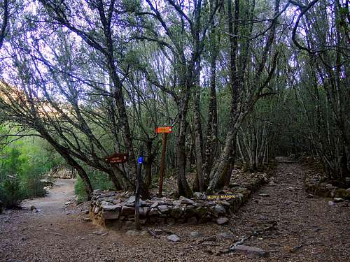
At the first junction along the dirt road, ignore the path on the left ( signposted Cascata Piscina Irgas) and take the right path (Muru Mannu). At the second junction that you meet ignore the path to the left ( leading to the Muru Mannu waterfalls) and take again the right path (N. 112 leading to the Linas sheepfold) that soon reaches a stone walkway over the Magusu stream, beyond which the path n. 112. Don't cross the walkway, but a few dozen meters before the bridge find a cairn on the right which marks the beginning of an unclear trail entering the wild valley of Gutturu Magusu, hardly marked by floods.

|

|
The path (n.110) becomes more marked a little further, rising up along the valley, now following the stony bottom now the edge of the stream, and it's marked by rare cairns and white-red signs. Just beyond, the path enters a dense forest of holm oaks marked by the work of the charcoal burners and arrives at a first little and not obvious fork where it takes the right direction, continuing to climb the valley in the dense forest and passing some ruins and charcoal piles. At a second very obvious fork in locality "Su coili de Cucaserra" you meet a big stone marking a junction: on the right you have the path n. 111 that climbs to the summit of the Magusu following a more demanding itinerary.


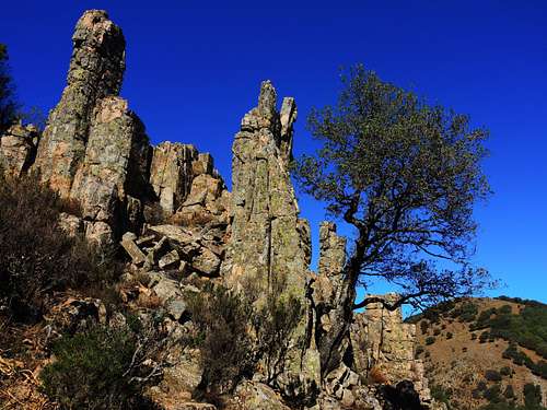
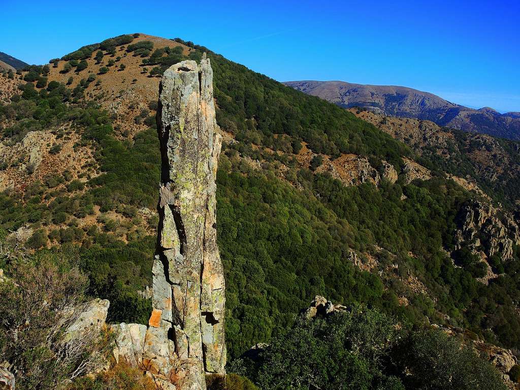
Proceed to the left (n.110), passing other charcoal pits and climb up the upper slopes where the ancient mule track damaged by the floods is visible. The Gutturu Magusu path ends near the vegetated saddle of Genna s'Ega Manna 823 m. Leaving the saddle on the left, proceed in the thick holm oak forest to the right of the saddle in the direction of the mountain, now clearly visible, reaching the base of a steep slope of large blocks. Climb easily the blocks up to a small notch. From the notch turn decisively to the right, climb up with easy climbing some rocky steps interspersed with small ledges, bordering an unmistakable spire surrounded by other characteristic rock formations.
Arrived near the jagged rocky summit ridge, turn sharplky to the left and proceed below the ridge along a system of ledges interspersed with some easy rocks, reaching the the base of an open stony slope that leads quickly to the summit cairn.
Descent: reversing the route
Red Tape
The area is wild and protected, anyhow there are no particular restrictions in hiking and climbing inside.
When to Climb
The climate of the area is typical of the Mediterranean, with mild winters and hot and dry summers. All year round, with exclusion of the summer months (too hot). The best season to climb Monte Arcuentu goes from September to May.
Hiking and scrambling scale
T - Turistico (Tourist): Itineraries on wide, clear and well worn paths, sometimes on mule tracks or gravel roads. The routes are never exposed, don't give any orientation problems and don't exceed 2500 meters of altitude. Suitable also for children.
E - Escursionisti (Hikers): Itineraries on marked trails, even narrow and with possible steep and impervious sections. They are never exposed and don't give any orientation problems. They can tread different kinds of ground, such as forests, gravel, meadows, pastures, easy rocks, etc.). They form the majority of the trails that wind up in the mountains and require a certain habit to walk; you need equipment suitable for the altitude and resistant footwear with soles suitable for rough terrain.
EE - Escursionisti Esperti (Experienced Hikers): Itineraries for hikers with experience and good knowledge of the mountain. Some of these paths may have exposed sections, however brief, which require firm foot and no dizziness. They require the ability to adapt to particular terrain, such as steep grassy slopes or stretches of rocks with difficulties that can reach the 1st degree of the UIAA scale. They can also reach high altitudes (3000 m or more). Sometimes they may include unmarked sections, requiring a good sense of orientation. Snow slopes are possible, however which can be overcome without specific mountaineering gear (rope, harness, crampons, ice-axe).
EEA - Escursionisti Esperti con Attrezzatura (Experienced Hikers with equipment - The same as EE, in addition these routes require the use of via ferrata equipment (lanyards, harness, carabiners, heat sink, helmet). This kind of itineraries range from the trails with short easy and not much exposed sections, previously equipped with fixed ropes and iron pegs, to the true and more difficult Via Ferratas climbing on rocky walls or on aerial ridges and ledges, previously equipped with long stretches of iron ropes, iron steps, ladders without which proceeding would constitute a real climbing. It is necessary to know how to use the technical equipment and have a certain habit of exposure and mountaineering terrains.
Accomodation
Farmhouses and B & B in Villacidro and surroundings
Meteo
Meteoblue Sardinia
Meteo ARPA Sardegna
Guidebooks and maps
- Sardegna - Maurizio Oviglia Guida dei Monti d'Italia Club Alpino Italiano - Touring Club Italiano 1997