
-
 7321 Hits
-
 85.36% Score
-
 20 Votes
|
|
Mountain/Rock |
|---|---|
|
|
39.59779°N / 8.54614°E |
|
|
Sardinia |
|
|
Hiking, Scrambling |
|
|
Spring, Fall, Winter |
|
|
2575 ft / 785 m |
|
|
Overview
Monte Arcuentu 785 m
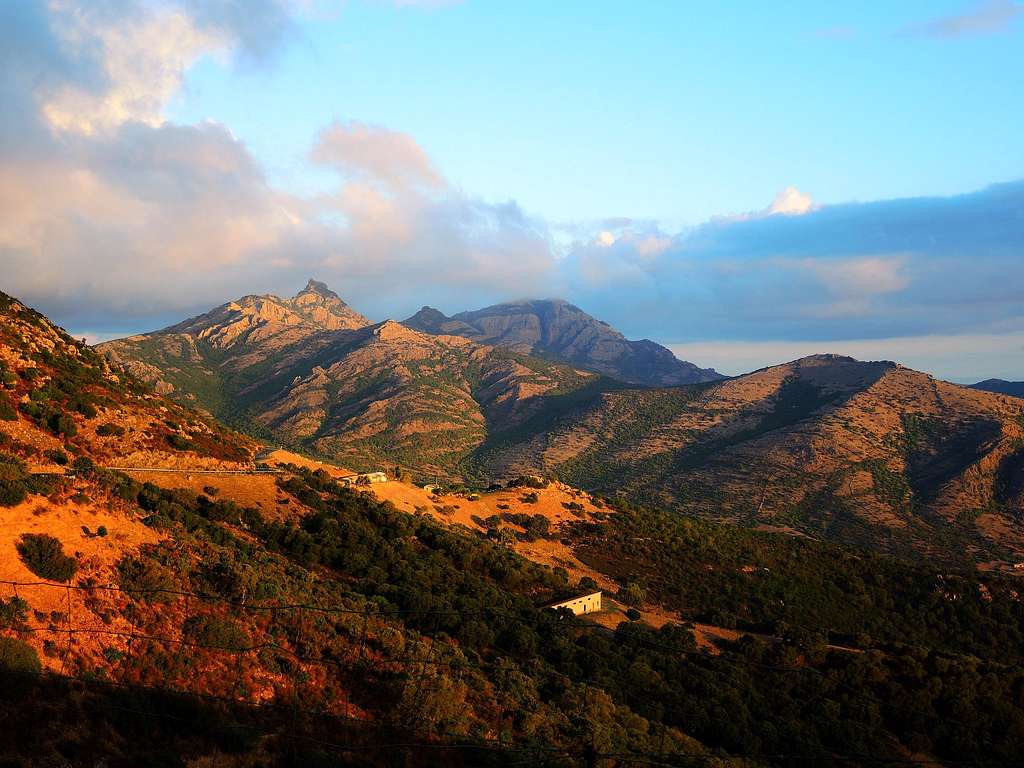
Monte Arcuentu 785 m is the highest peak on a mountain ridge located in the middle Campidano (South-Western Sardinia), North of the Linas massif and parallel to the Costa Verde. Monte Arcuentu is characterized by vertical walls and jagged ridges formed by volcanic rocks that give the mountain a particular profile. Its appearance and the isolated situation, dominating a broad hilly area that slopes gently towards the Mediterranean Sea make it unmistakable. The name of the mountain derives from the term "árku" which, in the Sardinian language, indicates the particular arched shape of the summit rocks. The name "Arcuentu" derives from the Sardinian word "arkù" - which means "arch" - referring to the arched shape of the summit.

|

|
Although not particularly high, Monte Arcuentu looks impressive in reason of its rocky structure and offers several reasons of interest that make it a completely recommended destination. In addition to the ascent route, an easy scramble with very interesting sections, the mountain offers an important botanical peculiarity: the summit is covered by a small but dense primary secular forest of holm oak (Quercus ilex). Moreover on the summit are located the remains of an ancient medieval castle; in reason of the secluded position of the mountain it is possible to observe a vast panorama over the island with the gulf of Oristano, the Gennargentu, the massif of Montiferru, the Sette Fratelli, Mount Linas and the Campidano plain. The wilderness of the place favors the presence of a rich fauna, formed by foxes, wild boars, martens and above all by the well-known Sardinian deer.

Getting There
Sardinia, the Westernmost region of Italy, can be reached by plane, otherwise by ferry-boat from Livorno, Civitavecchia and Genova harbors.
The starting point to climb Monte Arcuentu is located on the locality "Sa Tanca", along the road between Montevecchio and Marina di Arbus.
Road access
From the town of Guspini take the SP n. 419 that goes up to the Montevecchio mining center, where we turn right towards the Costa Verde and Marina di Arbus. After about 6 km from the village leave the main road at a signpost "Monte Arcuentu" and turn right, following for a few hundred meters a dirt road that ends in a parking lot in front of a farm on the right and a sheepfold on the left. Here it starts the standard route of ascent to Monte Arcuentu.
Route
Monte Arcuentu Normal route
Difficulty: EE
Difference in level: 490 m
Starting point: Agriturismo Arcuentu 300 m.
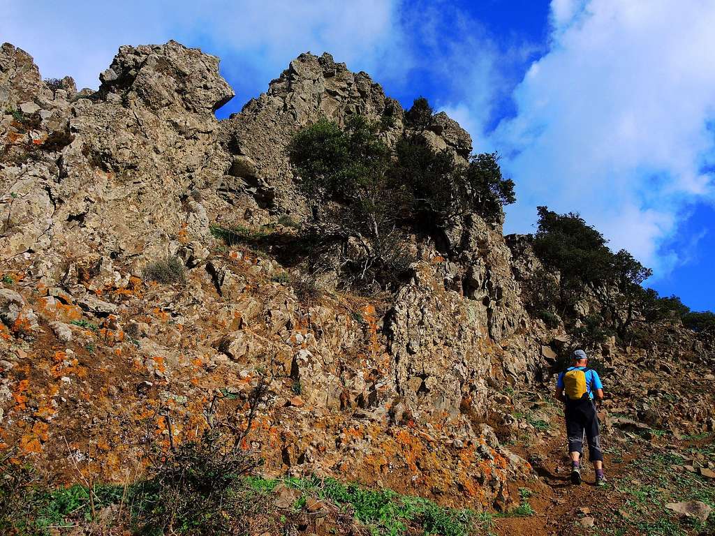
From the parking lot, you enter the sheepfold through two small gates and exit on the opposite side by means of a third gate, giving access to a well marked mule track that you follow (picnic tables on the right). The mule track heads to the the left and turns into a small track starting to climb a steep hill in the direction of the clearly visible Monte Arcuentu, reaching a forest info panel and a wooden gate,

|

|
Go through the gate (to be closed after passing) and continue steeply along the trail now obvious, leading to the foot of the summit volcanic rock tower. Obliquate to the left, where the bronze plates of the Via Crucis stations begin.

|

|
Successively enter a rocky channel, overcome it with some easy steps of climbing and turn to the right at its end, continuing to climb on easy rocks that lead to the South Ridge of the mountain. Here the path changes direction heading North and entering an incredible ancient holm-oak wood. You can see the foundations of the ancient medieval castle of Arcuentu, some huts once inhabited by a hermit friar and a stone altar with an image of the Madonna.
|

|
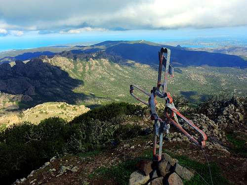
Continuing to proceed in the shady wood you will finally go out into the open to reach the summit cross and enjoy a vast panorama on the island and the Mediterranean Sea.
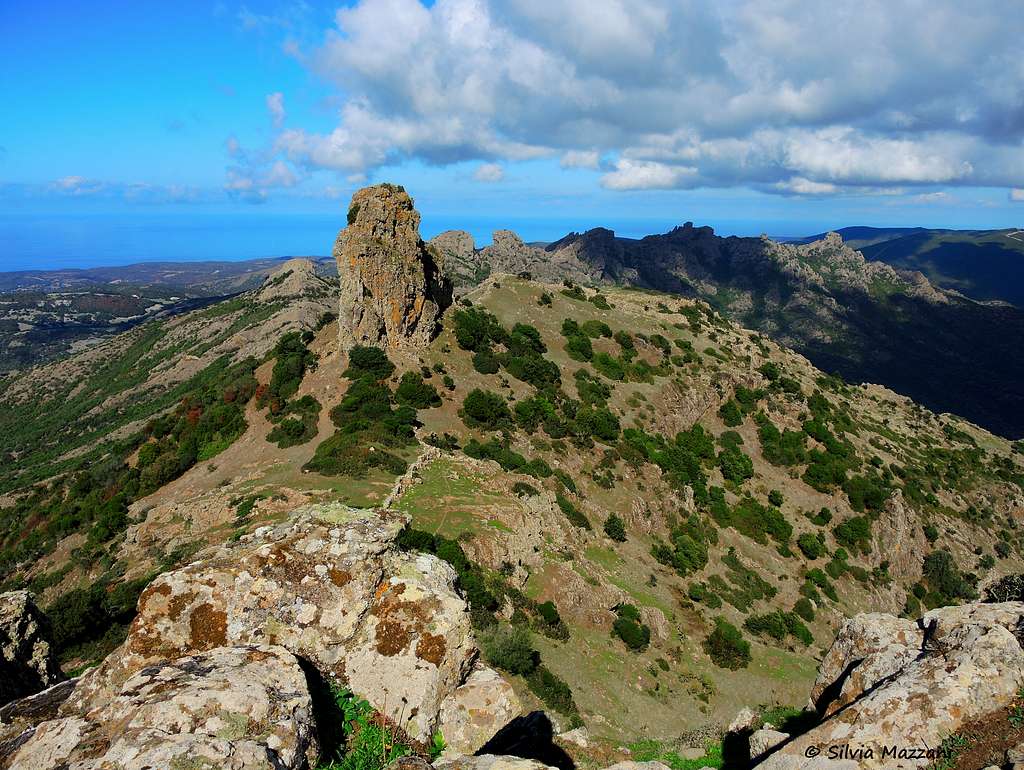
Descent: reversing the same route. When you reach the base of the rocks you can do a brief but advisable deviation from the itinerary to get the Arcuentuddu (meaning "Little Arcuentu"), a fine monolith situated close to Monte Arcuentu. At the bottom of the rocks head to the North (to the right, facing out) on a track to get the base of the monolith.

|
")
|
Red Tape
 forest on the summit")
The area is wild and protected, anyhow there are no particular restrictions in hiking and climbing inside. The wilderness of the place favors the presence of a rich fauna, formed by foxes, wild boars, martens and above all by the well-known Sardinian deer. The summit is covered by a small but dense primary secular forest of holm oak (Quercus ilex).
When to Climb
The climate of the area is typical of the Mediterranean, with mild winters and hot and dry summers. All year round, with exclusion of the summer months (too hot). The best season to climb Monte Arcuentu goes from September to May.
Hiking grades of difficulty
T - Turistico (Tourist): Itineraries on wide, clear and well worn paths, sometimes on mule tracks or gravel roads. The routes are never exposed, don't give any orientation problems and don't exceed 2500 meters of altitude. Suitable also for children.
E - Escursionisti (Hikers): Itineraries on marked trails, even narrow and with possible steep and impervious sections. They are never exposed and don't give any orientation problems. They can tread different kinds of ground, such as forests, gravel, meadows, pastures, easy rocks, etc.). They form the majority of the trails that wind up in the mountains and require a certain habit to walk; you need equipment suitable for the altitude and resistant footwear with soles suitable for rough terrain.
EE - Escursionisti Esperti (Experienced Hikers): Itineraries for hikers with experience and good knowledge of the mountain. Some of these paths may have exposed sections, however brief, which require firm foot and no dizziness. They require the ability to adapt to particular terrain, such as steep grassy slopes or stretches of rocks with difficulties that can reach the 1st degree of the UIAA scale. They can also reach high altitudes (3000 m or more). Sometimes they may include unmarked sections, requiring a good sense of orientation. Snow slopes are possible, however which can be overcome without specific mountaineering gear (rope, harness, crampons, ice-axe).
EEA - Escursionisti Esperti con Attrezzatura (Experienced Hikers with equipment - The same as EE, in addition these routes require the use of via ferrata equipment (lanyards, harness, carabiners, heat sink, helmet). This kind of itineraries range from the trails with short easy and not much exposed sections, previously equipped with fixed ropes and iron pegs, to the true and more difficult Via Ferratas climbing on rocky walls or on aerial ridges and ledges, previously equipped with long stretches of iron ropes, iron steps, ladders without which proceeding would constitute a real climbing. It is necessary to know how to use the technical equipment and have a certain habit of exposure and mountaineering terrains.
Accomodation
Farmhouses and B & B in Montevecchio and surroundings
Meteo
Guidebooks and maps

- Sardegna - Maurizio Oviglia Guida dei Monti d'Italia Club Alpino Italiano - Touring Club Italiano 1997