
-
 4891 Hits
-
 85.36% Score
-
 20 Votes
|
|
Mountain/Rock |
|---|---|
|
|
47.08678°N / 14.55186°E |
|
|
Hiking, Mountaineering, Via Ferrata, Skiing |
|
|
Spring, Summer, Fall, Winter |
|
|
7566 ft / 2306 m |
|
|
Overview
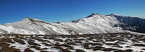
Approaching Kreiskogel from the N-NW
Perhaps all the rounded summits of Seetaler Alps do not deserve their own pages, but a few words and pictures of Kreiskogel could not do much harm. At the end, it has a respectable altitude and is a nice tour goal. And more - in the rocks above Winterleitensee they made a short, but extremely difficult ferrata. One wouldn't expect that on these grassy hills!
As I was only once on top of Kreiskogel, whoever knows this area better, please let me know to give you editing or admin rights.
The massif of Seetaler Alps is stretching some 35 km in the SSE-NNW direction. Its summits are rising only little above the ridgeline, so all along the main ridge of the massif a hiking trail goes. Many paths, marked and unmarked, are reaching the ridge from both sides, and because the slopes are generally not very steep, the mountain can be also crossed in virtually any direction by a pathless terrain. Steeper sections can be avoided, only in winter conditions they require more care, especially if snow is hard. What must be taken into consideration on this massif are the distances which can make otherwise easy tours more demanding.
North of Zirbitzkogel, 2396 m, the highest summit of Seetaler Alps, there is Scharfes Eck, 2364 m, the summit with meteorological radar devices. The continuing ridge goes further towards the NW, then it descends more steeply down on a saddle and rises again on the summit of Kreiskogel, 2306 m. Being around 1 h 30 min away from Zirbitzkogel, Kreiskogel can also be a goal of an idependent mountain hike. More towards the north, the main ridge becomes much more humble, it rises again on Point 2173 m and then on Wenzelalpe reaches the altitude of 2000 m for the last time. From Scharfes Eck a short side ridge branches towards the NE. Between it and the main ridge a quite closed high basin is situated. It is called Ochsenboden. There is a little lake in it and NE of it there's also a bigger and more popular Winterleitensee. Otherwise on both sides of the main ridge there are alpine meadows, nowadays more or less abandoned as pastures.
Getting There

Olsa valley

Greith
See the main page of Lavanttal Alps how to get in the valley of Olsa on the west, the main valley of Mur on the north or the valley of Lavant and on the saddle of Obdach on the east! From these three valleys the tours can start:
1. The most obvious and shortest is the approach from Winterleitenhütte, 1782 m. In summer it can be reached by car. In times of tour skiing we can usually drive only till Schmelz, 1550 m. The mountain road (Seetaler Strasse) starts in Mur valley, in Judenburg.
2. the second option from the east is Sabathyhütte, 1620 m, which can be reached by a mountain road from Obdach via St. Wolfgang. But from Sabathyhütte one needs to ascend first to Winterleitenhütte and only from there on top.
3. On the western side you can start the tour at Zirbenwirt hut (also Oberberg Schutzhütte), 1630 m. In summer it can be reached from Neumarkt via Greith and Oberberg.
4. Longer are approaches from the south, from Zirbitzkogel, on top of which also a mountain hut stands. It is reachable from several trailheads (see the page of Zirbitzkogel).
Routes Overview
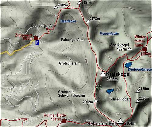
1. From the east. The shortest ascent route on Kreiskogel comes from Winterleitenhütte, 1782 m. Even if you are coming from Sabathyhütte, 1620 m, or from Schmelz, 1550 m, below Winterleitenhütte, it is a good 2 h ascent only. From the hut you continue by the path No. 08 to Winterleitensee, 1840 m, deter there right (north) and ascend the ridge between Speikkogel and Kreiskogel. Then by the ridge (or its N slopes) on top. This can be also done as a ski tour ascent, skiing from the summit is then done by the northern slope down and towards the east around to the hut, or, as the second option, you traverse (hard passage) by the ridge towards Scharfes Eck and then down in Ochsenboden. Route description in German is here.
2. Lukas-Max-Klettersteig. From Gr. Winterleitensee you deter right into this short, but extremely hard ferrata (Austrian rating is E), some 300 m, 30 minutes. Route description in German is here.

On Wenzelalpe
3. From the north-west. You start by Zirbenwirt, 1630 m. The inscription on the plate there says it's 4 h 30 min to Zirbitzkogel, less to other summits in the neighbourhood. This information may be strange, because the distance is not that big, and elevation to be gained is also less than 800 m. But no marked path goes there directly up. The marked path goes instead towards the SE towards the N-NE. We soon reach Oberberger Alm and continue by an open, mostly grassy slope towards the main ridge (once there was a ski piste). East of us is the valley which the path detours, even if the terrain through it is everywhere passable. So the marked path gains the main ridge between points 2082 m and 2151 m. There we turn right and go along the main ridge. Because there is a fenced military territory, the marked path goes a bit below the ridge, crossing the slopes all the time. I went there in snow, and because conditions were better on the ridge, I sticked to it. So I ascended the sharp Point 2173 m (Mitterriegel), descended it and continued by the ridge towards Kreiskogel. It's quite some distance, but I reached the base below the summit cone in less than 2 h. The summit ascent by the northern slope is rocky, but easy. The path actually crosses towards the eastern slope and then goes on top. Altogether some 3 h. This is also a nice ski tour as the slopes are all the time open. But going so much around is perhaps in winter not what one would wish, so from Zirbenwirt it is better to go directly eastwards. The ski tour goes towards Paischger Alm (hunters path) and then over nice slopes towards the SE and on top. Be careful in bad conditions and low visibility!

Scharfes Eck
4. From Scharfes Eck. No matter how you come on Scharfes Eck, the continuing goes by the main ridge. You descend first to the Point 2292 m and from there towards the north on the saddle below Kreiskogel (cca 2200 m). The next 100 m of ascent is at first easy, then the marked path overcomes some easy rocks. Easy in dry conditions, some care is needed in snow, because the slopes down to Ochsenboden are steep. From the saddle between Scharfes Eck and Kreiseck a marked path also crosses the W slopes of Kreiskogel - for those who go long-distance by the main ridge and don't want to ascend just every summit in it.
Mountain Huts
- Winterleitenhütte, 1782 m. In summer reachable by car. Tel.: 03578/ 8210. E-Mail: winterleitenhuette@gmx.at. The hut is opened all the year, except in November. It has 3 double rooms, so 6 x 4 beds and one additional group room with 10 beds. Web link.
- Schutzhaus - Oberberg (ex Zirbenwirt), 1630 m. In summer reachable by car. Tel.: +43 (0) 664 88 499 489. E-Mail: office@schutzhaus-oberberg.at. Web link.
- Kulmer Hütte, 1819 m.
- Zirbitzkogelhütte, 2376 m. On the summit of Zirbitzkogel. Opened from June 20th to September 20th and also on weekends and holidays. 20 beds. Family Grillitsch, Tel.: 03578/8205 (Waldheimhuette).
Red Tape
The mountain is within Naturpark Zirbitzkogel-Grebenzen . The area east of the main ridge is closed for military purposes. There are warning plates on fences and you are obliged to make sure in mountain huts that during your visit military activities are not going on. I think I saw also electrical alarm devices, so perhaps hikers are warned also by sound.
When to Ascend?
Kreiskogel can be ascended any time of the year. The most beautiful seasons are early summer (mountain spring), autumn and the times when there are good conditions for tour skiing. This can be from November till March/April.