
-
 5681 Hits
-
 84.27% Score
-
 18 Votes
|
|
Mountain/Rock |
|---|---|
|
|
46.78149°N / 15.02333°E |
|
|
Hiking |
|
|
Spring, Summer, Fall, Winter |
|
|
5997 ft / 1828 m |
|
|
Topographic isolation: 500 m
Nearest higher summit: Kleiner Frauenkogel (1861 m)
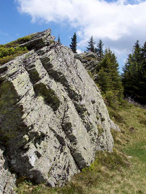
![Cliffs of Glitzkogel]()
Cliffs of GlitzkogelGlitzfelsen is a relatively high summit in Koralpe. Not the highest one: it is Grosser Speikkogel (2141 m). And there are 4 other summits over 2000 meter in Koralpe. Glitzfelsen is only 1828 m high. Still it is more interesting than most of the summits of Koralpe. Koraple has many round and flat summits. Rock formations are rare in this mountain range. Glitzfelsen is a rare exception. It’s a rocky ridge 4km east from Grosser Speikkogel, with many interesting cliffs.
The western neighbour of Glitzfelsen is Kleiner Frauenkogel (1861 m). The eastern neighbour is Glitzkogel (1734 m).
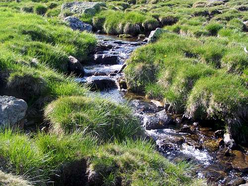
The ridge of Glitzfelsen forms the watershed of the Mur/Mura and Drau/Drava rivers. Mur is on the north side and Drau is on the south side. Rainwater falling on the north side soon joins the creek called Seebach, then Schwarze Sulm, then Sulm, then the river Mur. Rainwater falling on the south side starts its journey in Glitz Bach, then in Krumbach, then in Feistritz Bach that joins Drava. The rivers Mur and Drau leave Austria, then they cross Slovenia and Croatia, and finally their confluence is on the Croatian-Hungarian border. In 160 km distance this rainwater meets again.![Glitz Bach and Violet Fescue]()
Glitz BachGlitz must be pronounced ‘glits.
Perhaps it is the modification of German glitzern to glitter, from Middle High German glitzen; akin to old Norse glitra to glitter.
Based on this Glitzfelsen can be translated to Glittering Rock or Glittering Cliff.
Looking to the cliffs of the mountain they are not specifically glittering. So the name “Glitz” could have been transferred from another toponym. There are many other “Glitzs” around:
- Glitkogel (another summit of the same ridge)
- Glitztal (a valley below the peak)
- Glitz Alm (mountain pasture)
- Glitzalm-Hütte (a hut)
- Glitz Bach (a creek)
What can be glittering among them? The creek. So most likely the name of the summit derives from the creek below.
But there is a chance for Slavic origin for this name, too. Slavs inhabit the area from the 6th century. Bavarian settlers arrived to the valleys east to Koralpe only around 1000. So the name of the creek, the valley and the summits starting with Glitz may derive from the Slavic word Oklica that was later assimilated to the German word Glitz. Oklica means 'remote area of a village'. It’s only my speculation. Who can prove the truth? I suppose nobody.
The top of the hill is grass covered – this “grass” specifically is East Alpine Violet Fescue (Festuca paniculata). There are pine trees on the slopes. Glitzfelsen is within a protected area due to its richness in flora and fauna. Some examples of colourful flowers on the summit and along the way leading here:
- Lychnis flos-cuculi (Ragged Robin)
- Campanula patula (Spreading Bellflower)
- Petasites albus
- Gentiana clusii (Clusius' Gentian)
- Sieversia montana (Alpine Avens)
- Soldanella pusilla (snowbell)
- Soldanella montana (snowbell)
- Dryas octopetala (White Dryas)
- Primula minima
- Sedum sp. (stonecrop)
- Rhododendron hirsutum
- Cvaccinium vitis-idea (lingonberry)
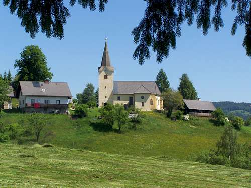
![St. Katharina in der Wiel]()
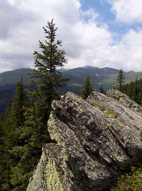
St. Katharina in der Wiel, Koralpe![Looking west from Glitzkogel]()
The view of Speikkogel from Glitzkogel. Big distance yet![Glitzfelsen]()
The ridge of GlitzfelsenVia Alpina purple trail is a long-distance tourist trail, connecting the Juilan Alps in Slovenia via Koraple in Austria to Obertsdorf in Germany.
From the main road that connects Eibiswald with Lavamünd, you can approach Glitzfelsen on Via Alpina if you start your tour at the village called St. Oswald. From there first you reach the gothic chapel of St. Katharina in der Wiel (15th century) to the Schwanberger-Brendl hut. The trail goes through extremely varied landscapes of woodland, meadows and fields, regularly passing traditional farms. From the Schwanberger Brendl hut you have to continue your way in forest that turns into Alpin pastures after a while. The elevation gain from St. Oswald to the Glitzfelsen cliffs is almost 1200 meter.
If you continue your way on Via Alpina, you will go via Kleiner Frauenkogel and Ochsenstein peaks, passing along the Kleiner Speikkogel and Grosser Speikkogel and reach the Koralpenhaus lodge.
This section of Via Alpina is also called as Alte Weinstrasse (Old Wineroad).
This route is marked on maps as E6/505. On site it is marked with red/white/red stripes similar to the Austrian tricolor. But I have seen on site also boards with indication as “05”.
No other routes leads to Glitzfelsen. But there is a paralel trail south to it, in the valley Glitztal. Glitzalm-Hütte can be accessed on this other trail.![Gentiana clusii]()
Gentiana clusiiGlitzfelsen is within the corn zone of the Forestry of Prince Lichtenstein. Here it’s forbidden to collect any forest fruits or mushroom. It’s also a protected Natura 2000 area.![Schwanberger-Brendlhütte]()
Schwanberger-Brendlhütte on 1566 mI didn’t find any camping nearby, though I really wanted to find one.
Tourist huts
Koralpenhaus, 1966 m
The Koralpenhaus inn is situated in the federal province of Carinthia and has 50 beds. Open from mid December till end March and from beginning of June till end September. In the main hiking season, you are advised to book on phone.
Contact: +43 664/4536313
Schwanberger-Brendlhütte, 1566 m.
63 beds, with possible breakfast, lunch or supper. Open from June to September
Contact: Miss Maria Raunjak, +43 699/12196213
![Vaccinium vitis-idea (lingonberry)]()
Blueberry flowersUseful topographic maps
- Freytag & Berndt, WK 237 Koralpe, Lavanttal, Saualpe, 1 : 50,000
- Kompass, Nr. 218 Koralpe, Pack, Soboth, 1 : 50,000
- Bundesamt für Eich- und Vermessungswesen, ÖK 50 188, 189, 1 : 50,000
Useful guidebooks
- Österreichischer Weitwanderweg 05 "Nord-Süd-Weitwanderweg", ISBN 3-222-12571-6
- Lavanttaler Höhenweg
- Kärntner Grenzweg, ISBN 3-7084-0129-8
Nearest higher summit: Kleiner Frauenkogel (1861 m)
Overview
Cliffs of Glitzkogel
The western neighbour of Glitzfelsen is Kleiner Frauenkogel (1861 m). The eastern neighbour is Glitzkogel (1734 m).
The ridge of Glitzfelsen forms the watershed of the Mur/Mura and Drau/Drava rivers. Mur is on the north side and Drau is on the south side. Rainwater falling on the north side soon joins the creek called Seebach, then Schwarze Sulm, then Sulm, then the river Mur. Rainwater falling on the south side starts its journey in Glitz Bach, then in Krumbach, then in Feistritz Bach that joins Drava. The rivers Mur and Drau leave Austria, then they cross Slovenia and Croatia, and finally their confluence is on the Croatian-Hungarian border. In 160 km distance this rainwater meets again.
Some Etymology: What does it mean: Glitzfelsen?
Glitz Bach
Perhaps it is the modification of German glitzern to glitter, from Middle High German glitzen; akin to old Norse glitra to glitter.
Based on this Glitzfelsen can be translated to Glittering Rock or Glittering Cliff.
Looking to the cliffs of the mountain they are not specifically glittering. So the name “Glitz” could have been transferred from another toponym. There are many other “Glitzs” around:
- Glitkogel (another summit of the same ridge)
- Glitztal (a valley below the peak)
- Glitz Alm (mountain pasture)
- Glitzalm-Hütte (a hut)
- Glitz Bach (a creek)
What can be glittering among them? The creek. So most likely the name of the summit derives from the creek below.
But there is a chance for Slavic origin for this name, too. Slavs inhabit the area from the 6th century. Bavarian settlers arrived to the valleys east to Koralpe only around 1000. So the name of the creek, the valley and the summits starting with Glitz may derive from the Slavic word Oklica that was later assimilated to the German word Glitz. Oklica means 'remote area of a village'. It’s only my speculation. Who can prove the truth? I suppose nobody.
Flora
 |  |  |  |  |  |
- Lychnis flos-cuculi (Ragged Robin)
- Campanula patula (Spreading Bellflower)
- Petasites albus
- Gentiana clusii (Clusius' Gentian)
- Sieversia montana (Alpine Avens)
- Soldanella pusilla (snowbell)
- Soldanella montana (snowbell)
- Dryas octopetala (White Dryas)
- Primula minima
- Sedum sp. (stonecrop)
- Rhododendron hirsutum
- Cvaccinium vitis-idea (lingonberry)
Routes
St. Katharina in der Wiel, Koralpe
The view of Speikkogel from Glitzkogel. Big distance yet
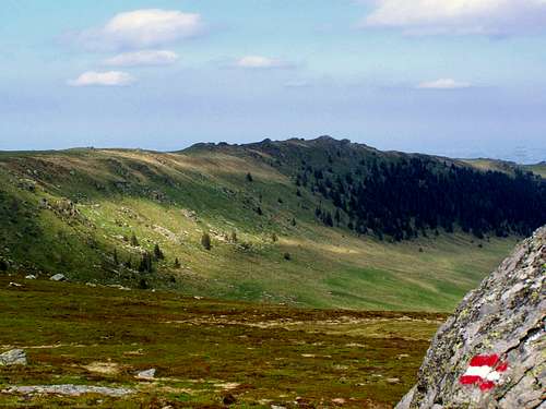
The ridge of Glitzfelsen
From the main road that connects Eibiswald with Lavamünd, you can approach Glitzfelsen on Via Alpina if you start your tour at the village called St. Oswald. From there first you reach the gothic chapel of St. Katharina in der Wiel (15th century) to the Schwanberger-Brendl hut. The trail goes through extremely varied landscapes of woodland, meadows and fields, regularly passing traditional farms. From the Schwanberger Brendl hut you have to continue your way in forest that turns into Alpin pastures after a while. The elevation gain from St. Oswald to the Glitzfelsen cliffs is almost 1200 meter.
If you continue your way on Via Alpina, you will go via Kleiner Frauenkogel and Ochsenstein peaks, passing along the Kleiner Speikkogel and Grosser Speikkogel and reach the Koralpenhaus lodge.
This section of Via Alpina is also called as Alte Weinstrasse (Old Wineroad).
This route is marked on maps as E6/505. On site it is marked with red/white/red stripes similar to the Austrian tricolor. But I have seen on site also boards with indication as “05”.
| __________________Segment__________________ | _Walking time_ | _Distance_ |
| St. Oswald > Jummernigg | 25 min | 1.6 km |
| Jummernigg > St. Katharina in der Wiel | 30 min | 1.4 km |
| St. Katharina in der Wiel > Jägerwirt | 85 min | 4 km |
| Jägerwirt > Schwanberger-Brendlhütte | 65 min | 3.5 km |
| Schwanberger-Brendlhütte > Glitzfelsen | 75 min | 4.3 km |
| Glitzfelsen > Kl. Frauenkogel | 20 min | 1.3 km |
| Kl. Frauenkogel > Ochsenstein | 30 min | 1.7 km |
| Ochsenstein > Koralpenhaus | 40 min | 3 km |
No other routes leads to Glitzfelsen. But there is a paralel trail south to it, in the valley Glitztal. Glitzalm-Hütte can be accessed on this other trail.
Red Tape
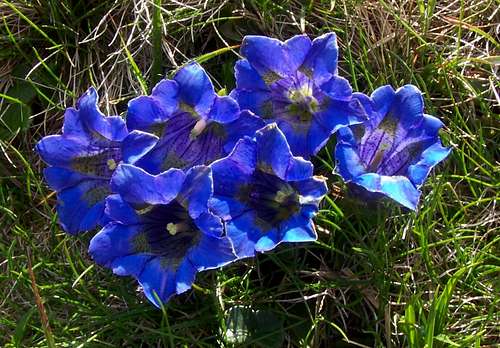
Gentiana clusii
Accomodation
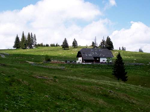
Schwanberger-Brendlhütte on 1566 m
Tourist huts
Koralpenhaus, 1966 m
The Koralpenhaus inn is situated in the federal province of Carinthia and has 50 beds. Open from mid December till end March and from beginning of June till end September. In the main hiking season, you are advised to book on phone.
Contact: +43 664/4536313
Schwanberger-Brendlhütte, 1566 m.
63 beds, with possible breakfast, lunch or supper. Open from June to September
Contact: Miss Maria Raunjak, +43 699/12196213
Maps and guidebooks
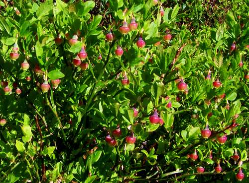
Blueberry flowers
- Freytag & Berndt, WK 237 Koralpe, Lavanttal, Saualpe, 1 : 50,000
- Kompass, Nr. 218 Koralpe, Pack, Soboth, 1 : 50,000
- Bundesamt für Eich- und Vermessungswesen, ÖK 50 188, 189, 1 : 50,000
Useful guidebooks
- Österreichischer Weitwanderweg 05 "Nord-Süd-Weitwanderweg", ISBN 3-222-12571-6
- Lavanttaler Höhenweg
- Kärntner Grenzweg, ISBN 3-7084-0129-8