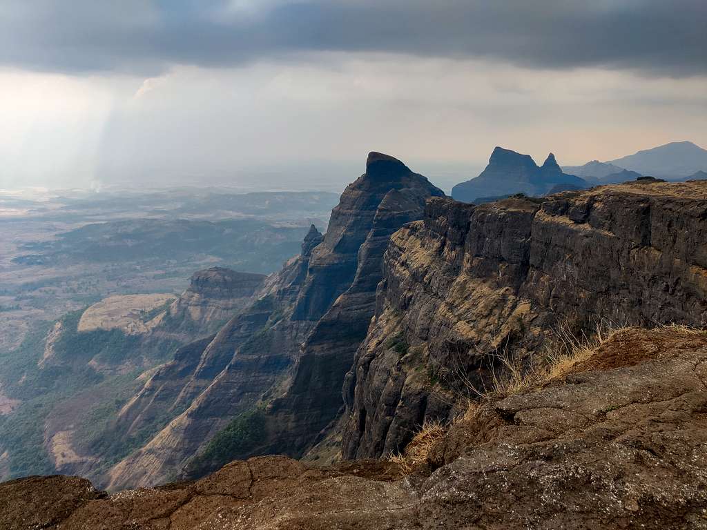
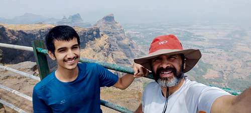
Whooaa!!! Is THAT what Balya Kaka climbed???? asked my son, mesmerized, terrified and pointing at the famous Konkan Kada, one of the largest rock walls in Sahyadri range of the state of Maharashtra. "Kada" in Marathi language means "Face" or "Cliff". This is one of the highest cliff in the state of Maharashtra. And, Balya happens to be the nickname of one of the most well known climber/mountaineer from the city of Pune. His name is Vasant Vasant Limaye, who is a pioneer in Outdoor Management Development Programs (OMD) in India, through his company, based out of Pune.
IMG_20230505_154048
I visited Konkan Kada, which is a part of a fort called Harishchandragad near Nashik way back in 1998, with my cousin, Chaitanya.
IMG_20230505_074136
We had just planned it on the fly and went there using public transport.
IMG_20230505_085142
Little did we realize that the climb from Khireshwar was not too bad (except for the rock patch that comes at Tolar Khind), but the never-ending hike up and down small hillocks once you reach the top, that tires you to the core. Till you don’t see the flag on top of the temple on the fort, you basically have to just keep on walking!
IMG_20230505_081708
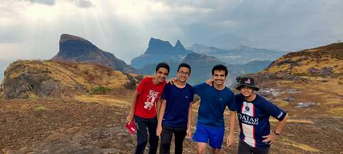
We were mesmerized by Konkan Kada then, and we are mesmerized now. I had always wanted to show it to my son, who has a keen interest in trekking, and has hiked close to 25 forts with me in the Sahyadri, and a couple of hikes in the Himalaya.
IMG_20230505_154306
While driving to the base village, I had narrated him the story of one of the most well-known climbers of Maharashtra (now a prolific writer), who had studied at IIT-B, initiated the mountaineering club at the institute, and led multiple expeditions, both in the Sahyadri as well as the Himalaya. One of the main highlights of his climbing career was that he opened the route on Konkan Kada, which is famously named after him, and is called – “Balyacha Route”. My son, Yuvaan had met him multiple times, so he was all the more excited to “witness” the rock face himself.
IMG_20230506_055945
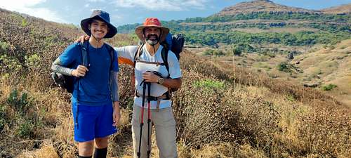
As it was a group of friends who were interested in coming for the trek, instead of Khireshwar, we chose to climb the fort through another village at the base called Pachnai. We left from Pune after finishing half a day’s work and reached late at the village. Beyond Rajur, there is absolutely no network, so it was a bit of a hassle finding roads at night, however we reached just fine. Ishan’s dad, Satyajit had planned the dinner at a local’s place over the phone.
IMG_20230505_184921IMG_20230505_171249
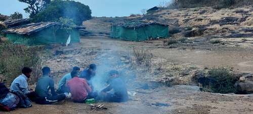
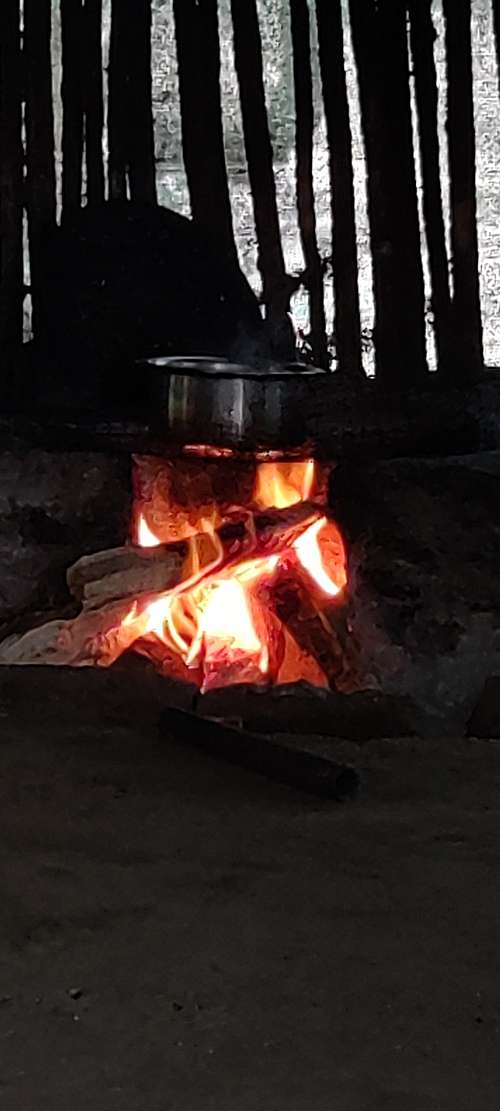
We reached, and while he and his family were making dinner, we pitched our tents outside his home, assuming there won’t be any rain. Post dinner, as soon as we got into the tents, within half an hour, it started raining. As they say – in the mountains, expect the unexpected! We hurriedly entered his home and slept in his kitchen, with the tents getting drenched outside. We had to do this because we didn’t have the flysheet with us, as we weren’t expecting any rain whatsoever.
IMG_20230506_055709
A good night’s sleep after a long travel from Pune was exactly what we needed to climb up Harishchandragad. After a quick breakfast and cup of tea, we set off to the fort. The route goes through the village, past the village well where ladies were gathered to fill their daily quota of water. We saw a couple more homes where hikers can rest/stay before they embark on the climb.
IMG_20230505_090525IMG_20230506_062133
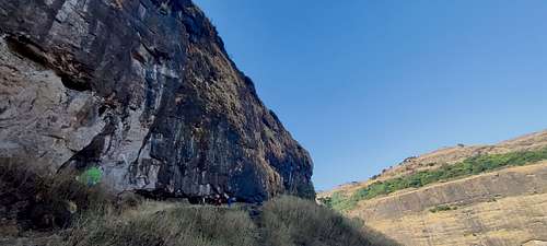
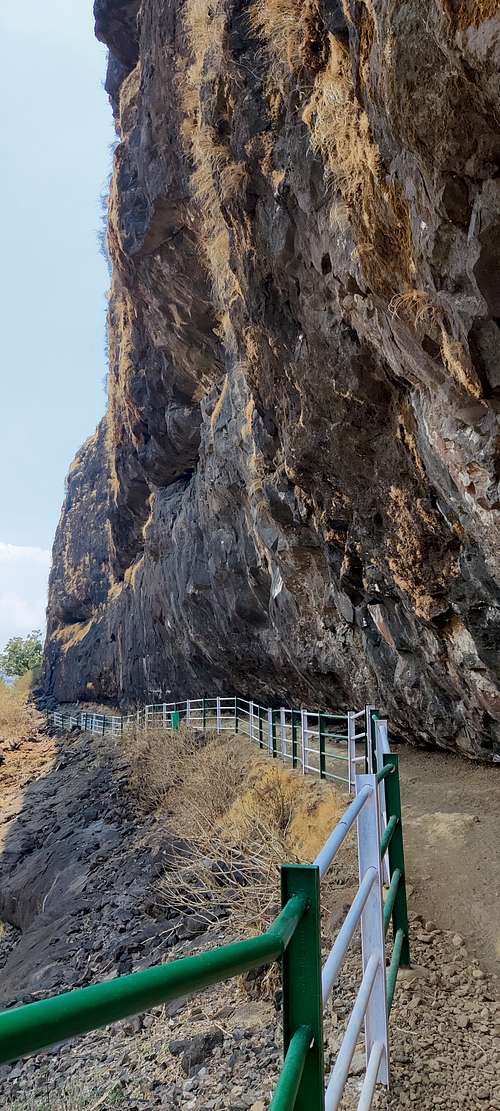
The route is well marked with an entrance on the road, where the trail begins. Past a few trees, we come out into the open where a small rock patch needs to be climbed. Once on top of it, we skirt along a massive rock face, with a trail marked at its bottom and railings installed, so that no one slips and falls. The rock faces and the multiple caves that get formed due to rain and wind were quite amazing to see. One could easily take a halt here for the night, if one wanted to. However, as the trail wasn’t that difficult, one usually goes all the way to the top before taking a halt for the night. Besides, trekkers always prefer to stay right next to the Konkan Kada.
IMG_20230506_071310
After crossing a few such rock faces, we came across a series of ponds which had some water in them. This usually would be a stream in the monsoons, leading to a waterfall at the end of the stream, which we would need to cross by using a bridge made for exactly that reason.
IMG_20230505_091812
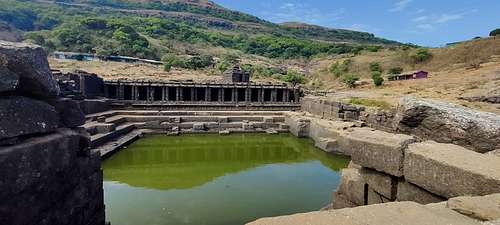
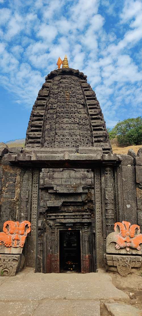
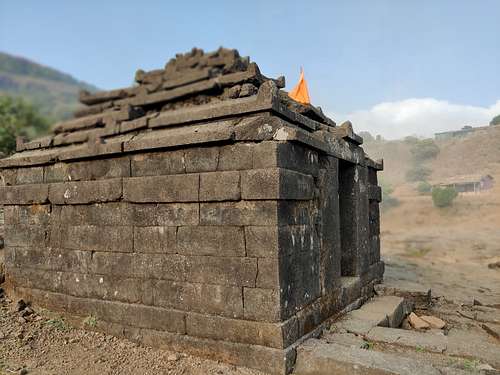
Once we go up from the small ponds section, within no time, we start seeing the top of the famous “Harishchandreshwar Temple”, a temple dedicated to Lord Shiva on Harishchadragad.
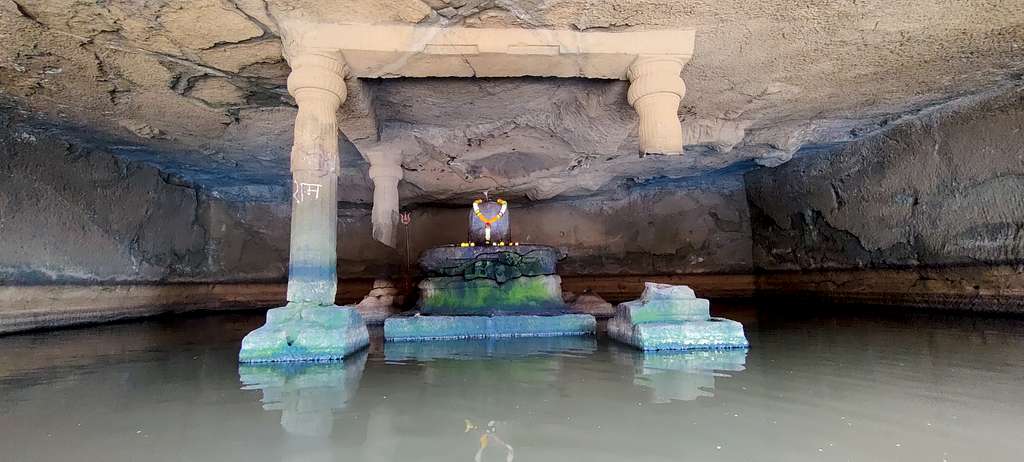
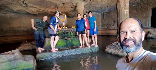
Just besides that temple, lies one of the most beautiful shivling I have ever seen!
I was mesmerized by this even when I had visited way back in ’98 but hadn’t gone into the waters. This huge shivling is in the middle of a cave which holds water all year long, and the cave is supported by 4 pillars, which depict 4 yugas which are spoken of, in Hindu mythology. We are in the last yuga – Kala-yuga, and hence the last pillar is still said to be intact. Once this yuga ends, the last pillar is also going to crash down in the water, there will be apocalypse and the whole world will end.
IMG_20230505_165930
The feeling that you get by just sitting there in front of the shivling is amazing! This is supposed to be the origin of the river Mangalganga.
I entered the water – which was way too cold and encouraged everyone to join me. At first, everyone hesitated, but once they saw that I made the entire Pradakshana (circle around the shivling), they were encouraged to join in. Slowly, the kids ventured into the water, and once they were in, there was no stopping them.
IMG_20230505_111827
They even insisted on going into one of the rooms on the side of the cave, where usually nobody goes in. There were bats inside, so they returned
immediately.
IMG_20230505_133050
After having a
heartful darshan of the shivling, we made way to Harishchandreshwar temple, which is known to be couple of thousand years old.
IMG_20230505_100900
The fort’s origin is said to have been from the 6th century, as many relics from the 11th and 14th centuries have been found here. A story about how the great sage Changdev meditated here, and challenged Saint Dnyaneshwar from here was narrated to us by Satyajit, while we were in the temple. He even showed us the underground cave behind the temple where the sage meditated in the 14th century.
The interesting thing on all forts in Maharashtra is that there are water cisterns from where potable water can be filled up, and which is fresh, cold and without any impurities in it. After filling up our bottles with fresh water, we started walking towards Konkan Kada, as we were supposed to either camp near it or sleep in a hut which belonged to the same person with whom we stayed the previous night.
IMG_20230505_170626
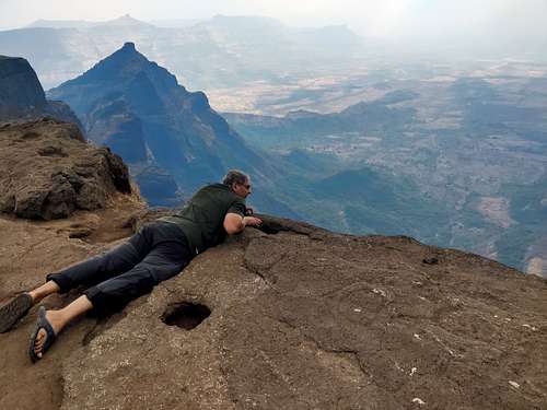
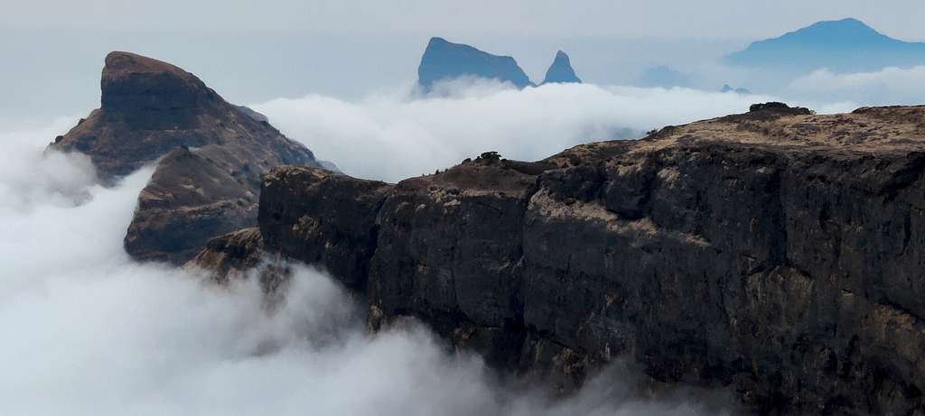
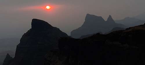
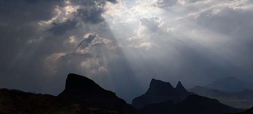
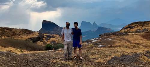
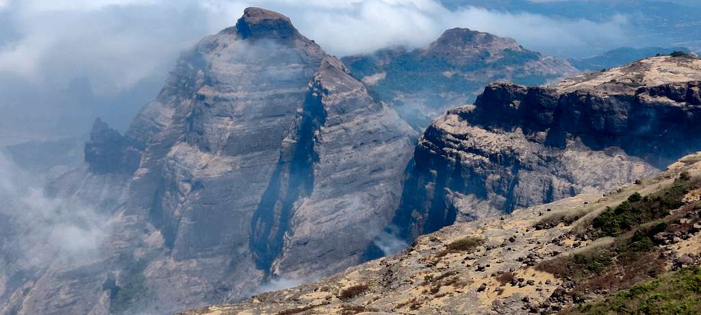
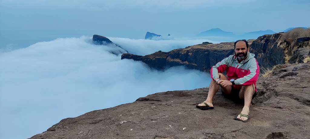
A short walk, and there we were – at the famous Konkan Kada! The vertical cliff that goes down straight 3000 ft. The mere glancing at the drop makes you dizzy. In1998, when I had visited there was no railing, and one had to lie down on your stomach, and witness the raw beauty of the rock face. This time though – I didn’t have the guts to do so. So, we basically stayed behind the railing and saw whatever was visible. This rock face is a semi-circular, curved face which is probably 2 kms from one end to the other. On one side, you have the mountain called Nafta (called Naftacha Dongar in Marathi), and its neighboring peaks jutting high into the sky, while on the other end, you get a chance to see the entire Malshej Ghat range with forts like Jivdhan and the likes.
IMG_20230506_100211
We all rested for a while in the shade of the trees, had lunch, and then walked towards the rightmost end of the face. Although we got wet in a sudden spell of rain, we could see the best views post the rain, in the background of Nafta. Somewhere at this location, a route from below comes up, which is called “Makad-Naal”. Makad in Marathi means Monkey’s route. It is a treacherous route to climb up to the fort, which involves rock climbing, and is best done with equipment at hand. We tried to see if we could see the route coming up, but beyond a certain point – nobody could peep down further. We captured some good pictures and set off towards the place where we had dumped our backpacks.
IMG_20230506_120136IMG_20230505_133050
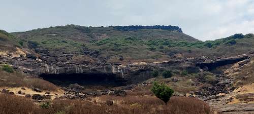
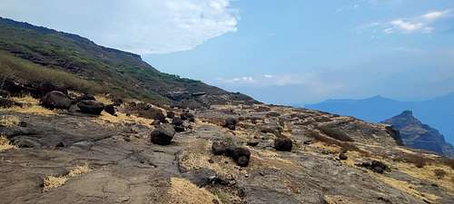
When we reached back there was still daylight, so we decided to head to the other end of the face, where I had never been before. It took about a kilometer and a half before we reached the other end of the face. However, it was interesting to see two huge caves on the way there, plus there was almost a field full of boulders, which must’ve come down from the top of the fort maybe a few thousand years ago. It was amazing to see so many boulders lying around, but we all discussed that it must’ve been a frightening sight for anyone to witness them rolling down the side of the fort.
IMG_20230506_093025
We spent a little time looking at the beauty all around us – Malshej Ghat, the massive Pimpalgaon Joga Dam on one end, and the massive Konkan Kada on the other. It was impressive to see a few of the faces of the Kada which normally are not visible from the main place where people sit and view it. And the Shendi pinnacle is right in front of your eyes from this point of view, which is equally beautiful, rising in the sky from below.
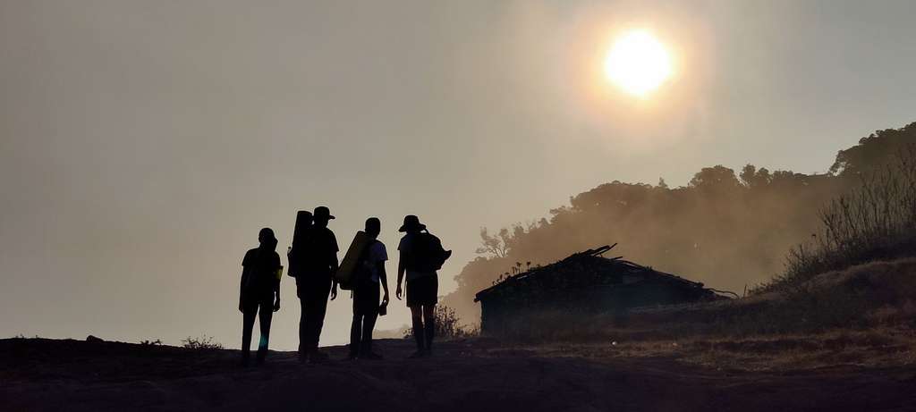
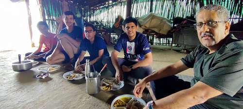
Before the sun set, we started walking back to our tent, and witnessed a magnificent sunset when we reached there. A quick, but healthy and wholesome dinner of Bhakri, Usal and Lonche was followed by all of us finally resting for the day!
IMG_20230506_092219
The next day was going to be equally adventurous, as we had planned on seeing both Taramati and Bale-killa. But, before witnessing the area around us from the topmost point on the fort, we saw something spectacular. Satyajit got up at 5 am for nature’s call and upon returning, he shouted for all of us to come out immediately.
IMG_20230505_175848
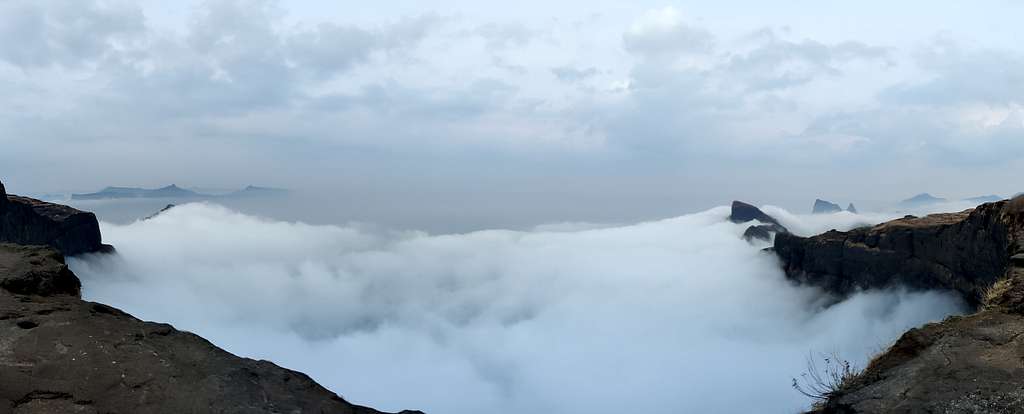
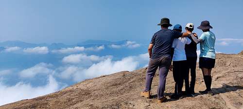
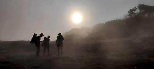
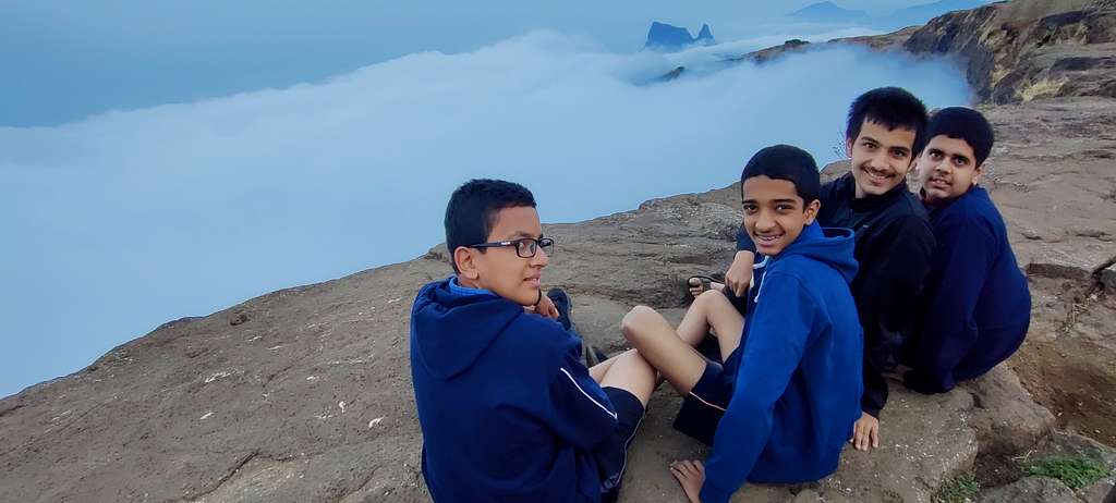
We all ran out to see something truly out of this world! The entire Konkan Kada was filled with clouds, and there was nothing that was visible under the sea of clouds. It was as if God had filled his cup full of milk with froth on top of it. The sea of clouds actually pumped all of us up, and we could muster the courage to go beyond the railing and take pictures sitting just feet away from the 3000 ft. drop. It was amazing, as we couldn’t do this the previous day, when the depth was visible. It’s amusing how our brain works in the face of danger, isn’t it. The kids also courageously went beyond the railing, to get a few photos taken of them in a group as well as solo.
IMG_20230506_061001
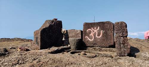
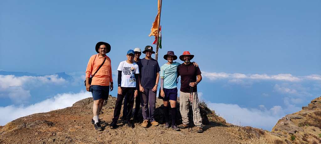
We realized that Taramati was the highest point, and Bale-killa was far away from the Harishchandreshwar temple, so we opted not to see it. Also, we had to keep our backpacks at some place, as there was no point in climbing all the way to Taramati with sacks on our backs. So, we set off to the temple where we found a small dhaba which had just opened for business. We dumped our sacks there, and just took the bottles of water to go up to the highest point on the fort. It consists of a Shivling and a flag only but the views that you get from the top are splendid.
IMG_20230506_090034
We could see the entire Konkan Kada, partially filled with clouds now, as sunlight had cleared some of them. A 360-degree view from the top helps one locate Ratangad, Alang-Malang-Kulang forts, Jivdhan, and many other prominent places around the fort. Satyajit showed us the Katrabai pass which is used to connect Harishchandragad and Ratangad, which is a range trek. I always say that Nashik and its adjoining areas are so richly endowed with nature that one could spend days here.
IMG_20230506_064646
A hike down to the same place where we stayed the night and we had to do a circle to the dhaba where we had kept out sacks, to pick them up and head down to Pachnai.
IMG_20230505_175501
The kids were good friends from school, and it was good that they bonded well on the trek. By the time we reached the base village, everybody was tired, but was ready to jump into the car to head back home.
IMG_20230506_071244
A sumptuous meal in Rajur, followed by sweet in the form of a Pedha, which was freshly being prepared, put all of them to sleep while I and Satyajit took turns driving and getting these young, tired souls back home.
Parents refers to a larger category under which an object falls. For example, theAconcagua mountain page has the 'Aconcagua Group' and the 'Seven Summits' asparents and is a parent itself to many routes, photos, and Trip Reports.


Comments
Post a Comment