
-
 7385 Hits
-
 85.36% Score
-
 20 Votes
|
|
Mountain/Rock |
|---|---|
|
|
46.37435°N / 14.68949°E |
|
|
Hiking, Trad Climbing, Sport Climbing |
|
|
Spring, Summer, Fall, Winter |
|
|
6263 ft / 1909 m |
|
|
Overview
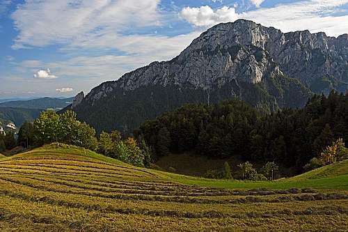
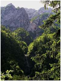
Križevnik from the north, from across the valley of Robanov kot
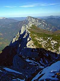
The NE ridge of Veliki vrh
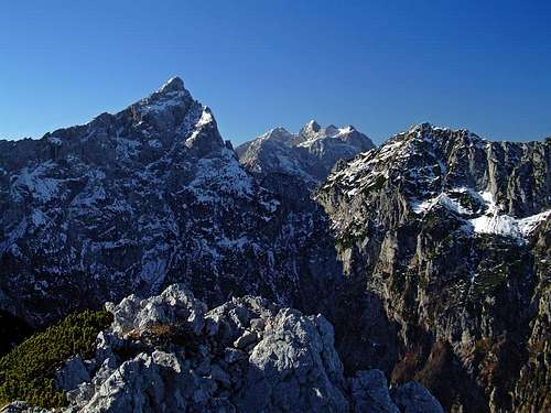
Ojstrica from the summit of Križevnik
Križevnik is the last summit in the long ridge, which goes from Veliki vrh and Velika zelenica towards the North-East. Even if this ridge soon lowers below 2000 meters of altitude, it still rises more than 1000 meters above the green valley of Robanov kot. So, its northern and northwestern slopes are rocky and very steep, no normal passage goes over them. Rather, in the fine northern limestone walls of Križevnik some very hard rock climbs were done. The other, southern and southeastern side of the ridge is far less spectacular. It lowers on the high plateau of Dleskovška planota (also called Veža) with short, no more than 300 meters high slopes, covered with dense dwarf-pine, grass and a few rocks.
Križevnik itself is almost to the top covered with dwarf-pines and nice larch woods. The name of Križevnik (pronounced Krizhevnik; križ means in Slovenian cross) originates from the fact that on its top three farm properties came together: Roban's, Poljšak's and Belšek's. Veliki vrh, 2110 m, and Velika zelenica, 2114 m, are described on a separate SP page. From Velika zelenica, the summit which rises just above Robanov kot valley, the NE ridge soon lowers significantly. The first summit in it measures 2028 m, the next one already only 1879 m. These are Poljske device (Polšak's Virgins). The higher 'virgin' (on old maps also referred as Molička peč) is easilly reachable, while the lower one would need some 'hair cut' - dense dwarf-pines prevent a just easy ascent. Then the ridge still lowers a bit, to some 1825 m, and finally rises again on the beautiful, panoramic Križevnik. After Križevnik, the ridge lowers considerably.
Covered with woods. Križevnik descends in a few rocky steps down to Belšek alpine meadow and finally all the way down to the canyon of Savinja river. As it rises in the middle of a quite remote world, you must rely only on non-marked paths. But the ascent is easy and also the paths are not very hard to follow. Some general orientation skills are however needed. As Ravne alpine meadow, 1500 m, on the south, can be reached by car, you need from there less than 2 hours to the top. Other approaches are much longer.
Naming of summits. Our member Andrej Mašera explains the story of different naming of the peak 2028 m. "In the past it was really named Molička peč, but after many debates the situation now is as the newest maps show it: peak 2028 m is the highest summit of Poljske device, actually the whole ridge is named so. Molička peč is a peak above Molička planina (meadow on the other side), west of Žvižgovec." Thank you, Andrej!
Summit Panorama
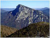
Raduha from Križevnik
Križevnik is remote enough to the highest mountains of Kamnik Alps to offer a great panorama. I would say that from nowhere the sharp Ojstrica is seen more beautifully than from the summit of Križevnik. Right of it a few nicely gathered summits of the central massif can be seen, more towards the right the whole ridge from Krofička to Strelovec stretches. In the distance there are: Olševa, Peca/Petzen, across Savinja river valley Raduha, further towards the East and South-East you can see much lower fore-hills. Towards the South the rounded summits, rising above the Dleskovška planota (plateau) can be seen. And, towards the South-West the ridge towards Veliki Vrh stretches, this summit nicely closes the north-eastern part of the plateau. Very impressive is also the view deep down into Robanov kot valley.
Caves In The Upper Dleskovska Planota
Below Veliki vrh, Velika zelenica and Poljske Device there's the upper plateau, where deep karst caves were found. Here's just a few data: The cave system Molička peč is currently with its depth of 1130 m the fourth deepest cave in Slovenia and the deepest one outside of Kanin mountain group. The system consists of two caves (Zadnikovo brezno and Ledena devica) which are on top 200 meters apart and which on the depth of 620 meters come together. The caves entries are 1900 and 1884 meters above the sea level. The system was mostly explored between 1991 and 1995.
Getting There

For a broader overview see the Kamnik Alps GROUP page!
If you intend to ascend only the summit of Križevnik or to do a nice round tour, as described in the following chapter, you'd probably drive with car to Ravne alpine meadow, 1500 m. Even if this is the southern approach, so from the central Slovenia, it is far from being a short one. The mountain road starts in Podvolovljek valley. This can be reached either by the main valley of Savinja and in Luče left (towards the SW) into the valley, or from Kamnik towards Črnivec pass, but just before it left (towards the North) to Volovljek pass and on the other side down into Podvolovljek valley. So, once you are in Podvolovljek valley, take the road, which starts ascending on Dleskovška planota high plateau some 500 meters below the inn 'Pri Gamsu', on 592 m. This road first crosses the slopes towards the right, then far towards the left and then around the beautiful Planinšek farm again towards the right and further northwards till the end point on Ravne meadow. On all crossroads this mountain road is well marked - with inscriptions 'Ravne'. Where not marked, keep on the stronger road.
From the NE Križevnik can be also reached from Savinja valley or Roban's farm (over Belšekova planina - meadow), but this path is long and also not marked, of course.
Routes Overview
3. The round tour over Veliki vrh.
Perhaps the finest hike in which Križevnik plays a role is to ascend its summit as described in #1, then continue by the main ridge towards the SW on Veliki vrh and finally return down on Ravne by the usual marked path. Some 5 hours 30 minutes, on the upper part of the ridge one or two easy rock passages.
Harder Climbs
In the climbing guide: Robanov kot, there are the following climbing areas above Roban's valley:
- Križevnik above Belšek alpine meadow,
- Turnca - Fore-walls of Križevnik, left part,
- Fore-walls of Krizevnik, Turnic,
- Fore-walls of Križevnik, right below Turnic,
- Fore-walls of Križevnik, right below the main wall,
- Krizevnik, North wall,
- Krizevnik, NE wall,
- Poljske device, N wall,
- Veliki vrh, N wall,
- Veliki vrh, SE wall.
So, you can see, that Križevnik has most of the routes. Some of them are:
- Resnik route, VI/V; 340 m; 5.5 hours. ...where for the route approach it is written there isn't any - you can belay your climbing partner from the bivouac bed...
- Ruše route, VI, 350 m.
- Ptičja pesem (Bird song), IX, 200 m. Done in 1988 by the legendary Franček Knez, with Andreja Hrastnik.
Red Tape
No limitations.
Camping
In the valley North of Križevnik, there's the famous Roban's farm. You can stay there for a longer period and enjoy all the hospitality of this family.
When To Climb?
The summit of Križevnik can be ascended in any season, but in winter crossing the high plateau would require a tour ski equipment.
Maps
Planinska zveza Slovenije: Grintovci. 1:25.000.