
-
 7695 Hits
-
 85.36% Score
-
 20 Votes
|
|
Mountain/Rock |
|---|---|
|
|
46.34426°N / 14.63460°E |
|
|
Hiking, Trad Climbing, Scrambling, Skiing |
|
|
Spring, Summer, Fall, Winter |
|
|
6447 ft / 1965 m |
|
|
Overview
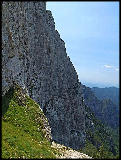
North-West wall

Dedec and Vezica from the N

Vezica from the N

General remark: When reading Slovenian words on maps or in books, you will find special characters for ch, sh, and zh. They are written with c, s and z with a caron - little v above them.
So, Vežica is pronounced Vezhitsa. South of Ojstrica, the easternmost high summit (2350 m) in the main Kamnik Alps crest, many mountains are rising out of a high plateau, called Veža. But a few side ridges, going in a southern direction can be distinguished too. In the ridge, or better a small plateau, which starts south of Korošica meadow with the summit of Lučki Dedec, there are two more summits worth to mention. The first one is Vršiči, 1980 m, higher of the two, but less important and the other one is Vežica, which with her impressive north-west wall plays an important role in technical and free climbing. This small plateau has nice, almost vertical walls on its north-western side, while the eastern side is less steep, the karst slopes are falling down in steps in the valley of Lučka Bela. Looking strictly, this crest branches after Vežica summit. One short, steep and rocky side ridge falls further down towards the SW into Kamniška Bela valley, while towards the south and later towards the south-west the crest continues first on Presedljaj saddle after which already the crest of Konj and Rzenik begins.
So, Vežica has a big, almost vertical northwestern wall, gentle, easy passable northern and eastern slopes and a steep, rocky with pine bush and lower with steep forrest overgrown southern slopes. The view from the top is similar than from Dedec, the most impressive is Planjava on the NW, fine is the view across Kamniska Bistrica valley, on Rzenik and Velika planina behind, while many other summits of the massif are not seen in their full size.
Vrsici


(The name is pronounced like: Vrshitchi).
Even if this summit is a bit higher than Vežica and the western side of its plateau also falls down on Šraj peski with a rocky wall, its importance is only secondary. A grassy bump rises only some 50 meters above the plateau and is easilly reachable. Due to dense pine bushes on other sides, the most recommendable ascent is from the saddle between it and Vežica.
Getting There
For a broader overview see the Kamnik Alps GROUP page!
|
1. From the south-west. The trailhead is on the road into Kamniška Bistrica (valley), 1 km before the hut and the end parking place, 571 m, from where we reach either Korošica hut through the valley of Kamniška Bela and Presedljaj (saddle, 1613 m), or go more directly over Šraj peski. From the road around to the hut 4,5 h, directly some 4 h. 2. From the east and southeast. By car we can reach Dleskovška planota (plateau). In Podvolovljek valley we take a decent macadam road, which brings us to Planina Ravne and the altitude of 1500 m. From the end parking place Korošica hut can be reached in 2 h 30 min. The second starting point can be the end of road below Planina Podvežak, 1400 m, some 500 m before reaching a hunters hut. 3. The third trailhead goes from Lučka Bela valley, where we can drive up to some 1050 m and continue by the marked path towards Stare stale and Prag. These are the options for a one-day ascent. Otherwise Korošica hut can be reached also from other directions, from Robanov kot, for example, or from Kamniško sedlo, when traversing the main crest of Kamnik Alps. |
Routes Overview

Sraj peski
Hikes
1. From Korošica hut. From the hut, 1808 m, we go in the SW direction by a climbers path, which brings us below the NW wall od Dedec. We continue ascending over the slopes towards the right, until the steep wall is over and a grassy passage named Durce opens. There we turn left up, reach the saddle in the ridge and continue on top of the western walls of the plateau towards the south. From agrassy saddle between Vršiči on the left and Vežica on the right we can easilly ascend each of the two summits. 1 h 30 min, easy, not marked.
2. Over Presedljaj. From the road in Kamniška Bistrica we go by the marked path into the valley of Kamniška Bela (towards the NE). After some 20 minutes the marked path starts ascending more decisively, now we gain altitude in many switchbacks. Gaining half of the elevation to the saddle we reach a nice bank with the open view on the surroundings. We are close to the northern wall of Rzenik, which can be later from a few places very beautifully seen. The path gets even steeper, but being well beaten and marked we have no problems with the ascent. In less than 3 h we reach the saddle, where from the right the steep, protected path comes down from Konj summit. On the saddle we turn northwards, towards Korošica meadow (Kocbekova koča). The path goes through dense pine bushes by an undistinctive ridge and then across steep eastern slopes of the massif. After some 30 minutes we reach the flat part of the path on the eastern side of the mountain. There we leave the marked path and turn by a shephards path towards the west (left). Over the meadows of Čohavnica pasture and through pine bushes we ascend on top. 4 h, steep marked path and finally easy but with pine bushes overgrown pathless terrain.

Over Sraj peski
Climbers in Vezica
3. Over Šraj peski and Durce. From the road in Kamniška Bistrica we go by the marked path into the valley of Kamniška Bela (towards the NE). By Orglice waterfall we continue by a non-marked path into the valley towards the north. A steep and hard hike-up has in the middle also a rocky step, where a short, but exposed easy climb is needed. Above, we reach Šraj peski, a steep and tiresome scree slope. We ascend it along the walls of Vežica and Vršiči, until above Petkove njive meadow we start ascending towards Durce pass. After reaching the plateau we turn left and go on top of Vršiči and Vežica as described in #1 above. Hard walk-up, difficult orientation, easy climbing passage. 4 h 30 min from the road.
4. From Lučka Bela. From the end of the road we go northwards by the marked path on the beautiful Stare Stale meadow. There we leave the marked path and try to find an old shepherds path which ascend in the western direction towards Čohavnica meadow. So we reach the higher marked path, going from Presedljaj saddle on Prag and further Korošica. Below Čohavnica we just cross this markeg path and continue by shepherds path towards the west. As described above in #2 we ascend over Čohavnica on top.
Even if four 'normal' ascents were described above, almost nobody uses them (except perhaps a few rare shepherds). Practically all visiters of Vežica are climbers. They descend from the nearby Korošica (Kocbek hut) along the western walls, do the climb and return over the wall as well. If you decide to hike on Vežica, the following two combinations are recommendable:
- Ascend over Šraj peski and Durce (#3 above) on Dedec, then turn soutwards and go on Vršiči and Vežica. Then descend by #2 in the valley.
- If going from Kocbek hut in the valley, go over Durce and take the three summits as described above.
Pine Bush Swimming
It happens so often to me! Finding myself in the middle of dense pine bush terrain, not willing to go back up again and correct the hike course. I knew that from Vezica it would be better to keep more towards the east. I even saw cows there on the meadow. But I still soon started to tend towards the right in the SE direction and came by nice meadows in a grassy valley. There was still no marked path, so I crossed it, tried to descend down the ridge on the other side, but the terrain was too rough. So, I came back in the valley and consulted my map. Here the ski tour should go down and indeed I saw two big iron poles showing in the direction of Presedljaj saddle. So I continued down the valley, following several cattle traces. But after a narrow, 2 meters high rocky step there were no more cattle traces. Well, the grass was still stepped down, I thought people must still descend there. No way. Some 50 more meters lower the pine bushes closed all around me. I searceh for a passage, but found nothing. The saddle was some 150 meters below me. So, the well proven technique must be used again - walking on pine bush branches, while holding the upper branches. It's so tedious, the sun is so hot, you fall of the branch so many times, climbing up again to reach at least on a certain level. And it's easier to cross the slopes than to descend. I was afraid also to find myself abov some rocky abyss in that jungle. Fought with those bushes at least an hour, in short pants, of course. It's easy for Tarzan, he at least has some space to swing. Below in pine bushes there were even some thorn plants, but it was obvious to be too late for a retreat. I struggled all the time towards the left, and only moderately down, which finally paid off. I reached on the marked path some 30 meters above the saddle. Better 30 meters than nothing! So, the lesson again is: Don't go directly down.
Climbs

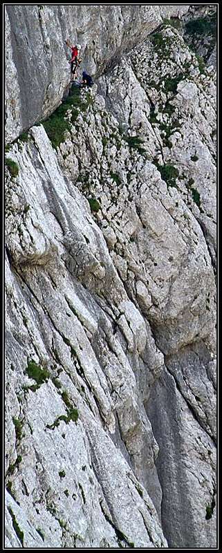
Climbers in Vezica

Climbers in Vezica
The wall of Vežica was already in 80's the place, where the more and more popular free climbing style moved climbing achievements foreward. At that time first free climbs of routes: Akademska (VII-), Lahova (VII) and Perčičev steber (VIII-) were top achievemnets.
In 1986 Srečo Rehberger made the free climb of Črna mačka (VIII+), Miha Praprotnik and Igor Jamnikar climbed Zaumak Nervo (VIII, A0) and also equipped it. This route was later in 1993 climbed free by Marko Lukič (IX+) and stayed several years the hardest free climb in Slovenia. (An adapted text, originally written by Tomaž Jakofčič, 2003.) The routes below are listed without any order:
- Geršak - Grčar. 390 m, V+, 5 hours.
- Petek, 13. (Friday, 13th). 200 m, 6c+. Silvo Karo & Klemen Mali, 13.06.2003. Topo.
- Športni dan (Sport Day). 250 m, VII-/VI. Urban Golob & Marjan Kovač, 31.05.03. Topo.
- Tik pred dvanajsto (Just Before Noon). 200 m, VII. Urban Golob & Miha Peternel. Topo.
- Nespodobno povabilo (Indecent Proposal).
- Akademska (Academic). 250 m, VII-.
- Tantalova direktna (Tantal Direct). 300 m, V+.
- Skrivnost človeškega uma (The Secret of Human Mind). 300 m, VI+.
- Lahova. VII.
- Perčičev steber. VIII-.
- Zaumak Nervo. VIII, A0 or free IX+. First free climb: Marko Lukič, 1993.
- Kramar - Močnik. 190 m, VII-/ V, A0.
- Last Minute. 270 m, X- or 8a+. First free climb: Marko Lukič, 2003.
- Pasja (Dog Route). VIII.
- Črna mačka (Black Cat). VIII+.
North of the summit of Vežica the steep western walls are cut by a ravine, where passage requires an easier climb. Predominantly this ravine requires only UIAA I climbing, but in one rock step difficulties arise on UIAA II and polished slabs can become tricky, especially if wet. A peg there may be of help. Besides for a descent this might be an option for shortening the ascent over Šraj peski, if we don't want to go around over Durce pass. But, as said, this is considerably harder. (Not knowing all these details, and being alone, I turned even before the climb started.)
Map
- Grintovci. Planinska zveza Slovenije, 1:25.000.
Red Tape
There are no limitations. The mountain is in the middle of a parc area.
Mountain Huts
The only real mountain hut, which supported ascents on Dedec is Kocbekov dom on Korošica meadow, 1808 m. In 2019 it burnt down and it's still not clear when it cill be renovated. Contact before was: (03) 4924850, (050)615625 and (031)749811, Milan Kozelj.
The other mountain hut is the hut in Kamniška Bistrica, 600 m, reachable by car. Contact: (01) 8325544.
When To Climb?
Summer and autumn (best months are usually July - October). Spring for tour skiing (Usually February - May).