
|
|
Route |
|---|---|
|
|
36.09849°N / 112.0949°W |
|
|
Hiking |
|
|
A long day |
|
|
Rim to Rim to Rim endurance run/ day hike - Overview
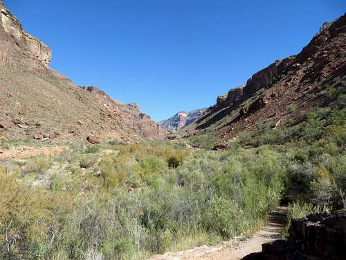
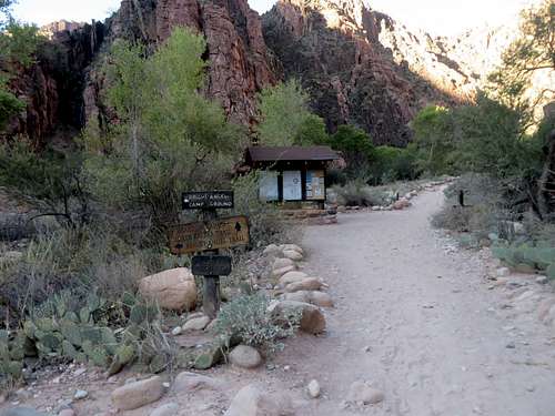
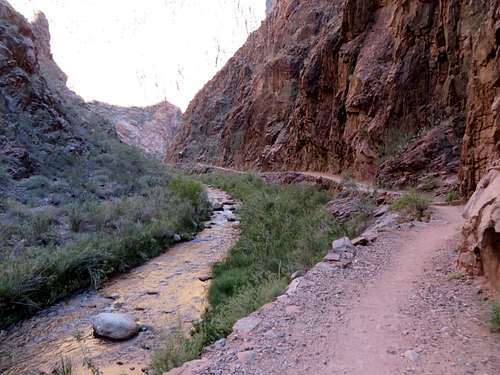
North Kaibab trail between the Box and Ribbon Falls
A Rim to Rim to Rim is a continuous event, only taking breaks for food, water and necessities. This endurance run ranges from 42 miles to 45 miles to 48 miles (official distances not including the inevitable side steps, detours and by-passes that add at least a mile to the distance), depending on the routes taken. As the name indicates, a RRR starts on one of the Grand Canyon rims, goes to the other, and comes back to the initial rim.
I hear people who claim of doing these hikes over a period of 3 to 4 days (and strongly recommending to others to follow suit, in order to "take in the beauty of the canyon.") I do not want to burst anyone’s bubble, but doing a Rim to Rim to Rim in multiple days is a mere camping trip and nothing else. Trying to take credit for completing a Rim to Rim to Rim in 2-3-4 days, while camping in the various camping sites along the trail, is like one would say he ran a marathon in 3 days, running 9 miles each day. That claim would be the ridicule of everybody, anywhere. Nobody that trail runs/ hikes a RRR does it for the beauty of the canyon but rather for accomplishing a grueling run/ hike in the shortest time of one's ability. A RRR tests the limits of the body, mind and spirit of most runners/ hikers.
There are claims by people who ran and completed a RRR in less than 10 hours and I read of hikers that finished the grueling undertaking in 36 hours. All of them did this as a non-stop "day hike" endeavor. There are voices that ask for a not-to-exceed 24 hours time limit for a RRR to be considered as such. As far as I am concerned, to everyone that completed a RRR as a "day hike", whatever it took to finish, congratulations. To everyone else that hiked a RRR by pitching a tent, you tell yourself what you want, but you did not do a RRR. You just went camping in the Grand Canyon.
There are hikers that like to call the RRR effort "the death march." As difficult as this trek might be, I don't like that terminology. Nobody goes on a RRR to kill themselves and most of the people that attempt the double crossing of the Grand Canyon are prepared and know what to expect. No many people who finish a RRR would be immediately ready for a soccer game, for sure. Being tired after running/ hiking almost 50 miles in high temperature, dry air and baking Sun, is no easy task. However, being very tired and having ugly looking blisters hardly qualifies for a near death experience.
The question is: how many RRR a person has to do to be memorable? The answer is: one. Do this trek more than once, and it becomes a statistic.
Getting There
There are three trailheads to start a RRR. All these three trailheads are inside the Grand Canyon National Park. Two of the trealheads are on the South Rim and one on the North Rim. Grand Canyon is in the northwest corner of Arizona, close to the borders of Utah and Nevada. Grand Canyon National Park lies entirely within the state of Arizona.
- Grand Canyon National Park's SOUTH RIM (open all year) is located 60 miles north of Williams, Arizona (via route 64 from Interstate 40) and 80 miles northwest of Flagstaff (via route 180).
- The entrance to the Grand Canyon National Park NORTH RIM is located 30 miles south of Jacob Lake on Highway 67; the actual rim of the canyon is an additional 14 miles south. Jacob Lake, AZ is located in northern Arizona on Highway 89A, not far from the Utah border.
Bright Angel Trail Head is located just left (West) of Bright Angel Lodge. Driving into the National Park follow signs for the "Village." The trail starts by mule corral. There is parking right next to the trail head.
South Kaibab Trail Head is located at Yaki Point, inside the Grand Canyon National Park. Yaki Point is the only viewpoint on Desert View Drive that is not accessible with a private vehicle. It can be reached using the free Shuttle Bus (Orange) departing from the Grand Canyon Visitor Center across the street from Mather Point on South Rim. Busses run from just before sunrise to just after sunset. The schedule changes slightly according to season, so check departing times on the Grand Canyon Visitor Center website (see below.) There is no private parking at this trailhead. Parking is permitted along the Desert View Drive, near the gate at Yaki point. However, there is a 1/2 mile (one way) walk to the trail head.
North Kaibab Trail Head is located 41 miles south of Jacob Lake on Highway 67 (1.5 miles north of North Rim Grand Canyon Lodge). Transportation is also available from the Grand Canyon Lodge (twice each morning; check at the lodge for times and fares) or, for those staying at North Rim Campground, it is a half-mile walk to the trailhead. Hikers on a rim-to-rim hike and who have only one vehicle often use the private Trans-Canyon Shuttle, which provides service between the North Rim (departs at 7 AM and 2 PM) and the South Rim (departs around 1 p.m.) daily from May 15 to October 31. North Rim park facilities (lodge, store, gas station) close on October 15, but Highway 67 remains open to vehicle traffic until winter conditions preclude access. Visitors should be prepared for road closure anytime after October 15, but often Highway 67 remains open into November. Once closed Highway 67 remains so until May 15. It is not possible to reach the trailhead by vehicle before May 15.
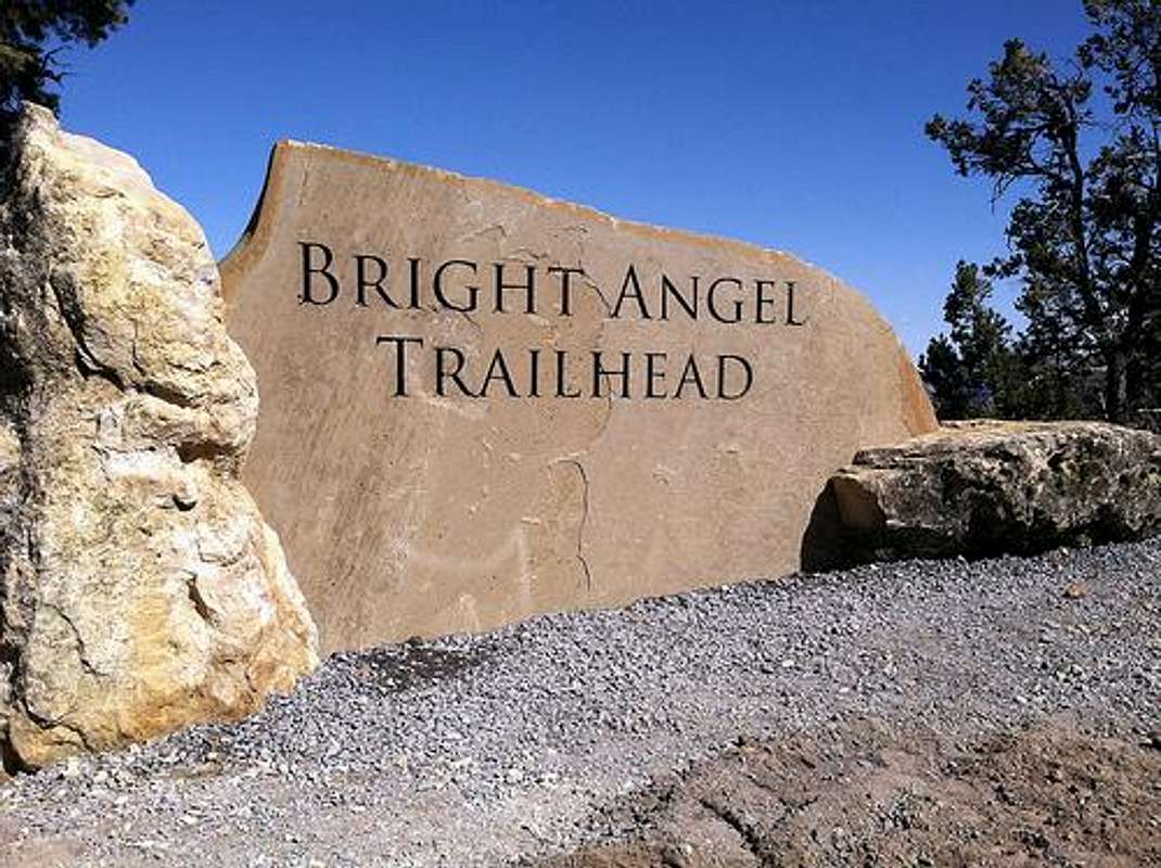 Bright Angel Trail Head | 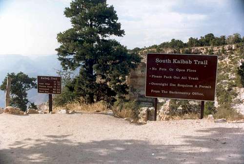 South Kaibab Trail Head | 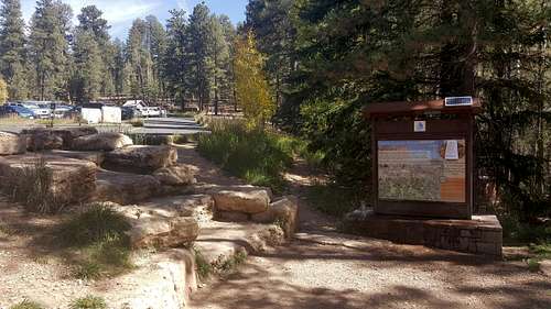 North Kaibab Trail Head |
Route Description
There are six possible ways for doing a RRR, depending on where one starts. There are two starting points on South Rim and one starting point on North Rim. All these three trails are well maintained and very easy to follow, literally impossible to get lost or accidentally off trail. However, it is not to be understood that these trails are as smooth as the trails in a city park; in certain sections, especially 5 miles down from each rim, they are as rough terrain as it gets.
Starting at South Rim:
Bright Angel TH to North Kaibab TH and back to Bright Angel TH - 48 miles
Bright Angel TH to North Kaibab TH to South Kaibab TH - 45 miles
South Kaibab TH to North Kaibab TH and back to South Kaibab TH - 42 miles
South Kaibab TH to North Kaibab TH to Bright Angel TH - 45 miles
Starting at North Rim:
North Kaibab TH to South Kaibab TH and back to North Kaibab TH - 42 miles
North Kaibab TH to Bright Angel TH and back to North Kaibab TH - 48 miles
There are pros and cons in relation to any route one will take.
Pros for starting and finishing at South Rim:
- easier to get to than going to North Rim;
- South Rim is 1,000 feet elevation lower than the North Rim, therefore making the finish at SR a little bit easier;
- there is water year round at both South Rim Trail Heads;
- Bright Angel trail has water every mile and a half in the top 4.5 miles: no need to carry too much water during this last segment;
- South Rim ususlly doesn't get so much snow or ice on trails to make it hard to go up and down;
- there is lodging and food services only feet away from the TH. Also, Tusayan town is only 15 minutes away from TH.
Cons for starting and finishing at South Rim:
- South Kaibab TH doesn't have private car parking so a bus has to be taken to and from TH;
- South Kaibab trail does not have water anywhere but at the TH, making the last 6.5 miles of RRR even more difficult;
- Bright Angel trail is the most crowded of the three and tourists will not give the right of way for going up, if hiked during the day;
- both South Rim trails are in direct Sun all day, making a mid day finish here that much difficult;
- there are mule trains (during the day), plenty of mule dung and piss on trails.
Pros for starting and finishing at North Rim:
- plenty of parking and ice cold water (May 15 to late October) at TH;
- the first 2 miles of the trail is mostly in the shade. The first 4.5 miles are mostly in the shade from 2 PM;
- the number of hikers on this trail is only a fraction than on the South trails;
- no mule trains below Supai Tunnel (1.7 miles from TH);
Cons for starting and finishing at North Rim:
- North Rim is very remote and requires a lot of travel to get to it;
- it is 1,000 feet elevation higher than the South Rim, making the finish here that much harder;
- on North Kaibab trail, on the hottest stretch from Phantom Ranch to Cottonwood Campground (6.9 miles) there is no water station;
- the lodging at North Rim is limited and reservations have to be made months in advance;
- during the winter months there is a lot of snow on trail on the top 4 miles, sometimes waist high.
Distances Breakdown
I noticed that psychologically it makes a big difference breaking down the entire distance in shorter segments. It is easier to think of getting to the next milestone that could be 1, 2 3 4 5 miles away rather than to keep thinking the entire day of the whole 42 to 48 miles. For convenience, here is a list of a breakdown of distance.
South Kaibab trailhead to Colorado River/ Bright Angel Campground/ Phantom Ranch - 7 miles
South Kaibab trailhead to Ooh Aah Point - .9 mile
Ooh Aah Point to Cedar Ridge - .6 mile
Cedar Ridge to Skeleton Point - 1.5 miles
Scheleton Point to Tonto Plateau - 1 mile
Ooh Aah Point to Cedar Ridge - .6 mile
Cedar Ridge to Skeleton Point - 1.5 miles
Scheleton Point to Tonto Plateau - 1 mile
Tonto Plateau to Tipoff - .4 miles
Tip Off to Colorado River/ Bright Angel Campground/ Phantom Ranch - 2.6
North Kaibab trailhead to Colorado River/ Bright Angel Campground/ Phantom Ranch - 14 miles
Phantom Ranch to Ribbon Falls (trail split) - 5.6 miles
Ribbonn Falls (trail split) to Cotonwood Campground - 1.6 miles
Cotonwood Campground to Pumphouse Residence - 1.4 miles
Pumphouse Residence to Roaring Springs - .7 mile
Roaring Springs to Supai Tunnel - 3 miles
Supai Tunnel to Coconino Overlook - 1 mile
Coconino Overlook to North Kaibab trailhead - .7 mile
Bright Angel Trailhead to Colorado River/ Bright Angel Campground/ Phantom Ranch-9.5 miles
Bright Angel TH to 1.5 Mile Resthouse - 1.6
1.5 Mile Resthouse to 3 Mile Resthouse- 1.5 miles
3 Mile Resthouse to Indian Garden - 1.7 miles
Indian Garden to River Resthouse - 3.2 miles
River Resthouse to Phantom Ranch - 1.5 miles
 Intersection in the canyon. Going straight is North Kaibab. Going left is Bright Angel. Going back is South Kaibab. | 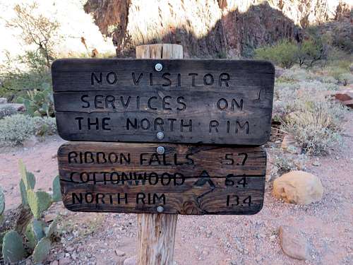 This sign is .2 mile North of Phantom Ranch | 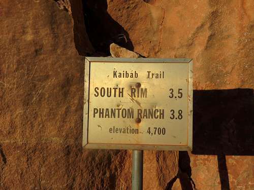 Midway on South Kaibab trail |
Water on Trail
A very important aspect of a RRR endeavor is water. Not needing to carry all necessary water for a RRR is a very important aspect. There is drinking tap water on all three main trails in the Grand Canyon. However, depending on the time of the year, some water stations are closed for the winter (usually from late October to May 15.) The water pipe is old and breaks many times during the year, therefore causing unpredictable water closures. I strongly suggest that before starting to hike down the trail, to visit the Backcountry Information Center and check any last minute water main closures. If the office is closed, they would have a note on the door listing the issues. (See link below for critical backcountry information/ water station availability.)
There is plenty of water in the canyon, from various creeks or springs. It is strongly recommended to treat the water. Nevertheless, during the monsoon season July to September, the water in the canyon is muddy and undrinkable unless filtered and treated.
Below is a list of the water stations along these trails and the distances between them (water available only from Mid May to late October:) (See NPS link below for water stations and the facilitiesw associated with them.)
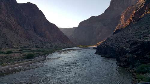
Grand Canyon - Colorado River
Bright Angel Trailhead – water year-round
Bright Angel TH - Mile-and-a-Half Resthouse – 1.6
Mile-and-a-Half Resthouse - Three-Mile Resthouse – 1.5
Three-Mile Resthouse - Indian Garden – 1.7
Indian Garden (water year-round)
Indian Garden – Phantom Ranch/Bright Angel Campground – 5.1
Phantom Ranch/Bright Angel Campground – water year-round
South Kaibab Trailhead – water year-round
South Kaibab – Phantom Ranch/ Bright Angel Campground – 7.3 miles
(There is no water, either tap or creek, on South Kaibab trail.)
North Kaibab Trailhead (the only place with ice cold water on this trail.)
North Kaibab TH to Supai Tunnel - 1.7 miles
Supai Tunnel to Roaring Springs - 3 miles
Roaring Springs to Pumphouse Rest Area - .7 mile
Pumphouse Rest Area to Cotonwood Campground - 1.4 miles
Cotonwood Campground to Phantom Ranch/Bright Angel Campground - 7.2
Phantom Ranch/ Bright Angel Campground – water year-round
Essential Gear
The right shoes are very important.
A good pair of trail running shoes. Flashlight with an extra set of batteries. Hiking boots or hiking shoes are not really necessary, unless the RRR is done during the winter months. Sun glasses, hat, sunscreen, a watch with night light, trekking poles can be used if only hiking, band-aides, iodine pills for treating creek water. Taping the feet should be strongly considered. One can carry a cellphone, but the cell reception only goes 3 miles down the trail from the South Rim. There is no reception anywhere after that, including at the North Rim North Kaibab Trail Head.
Red Tape
$30 a car fee for entering the National Park.
General Considerations
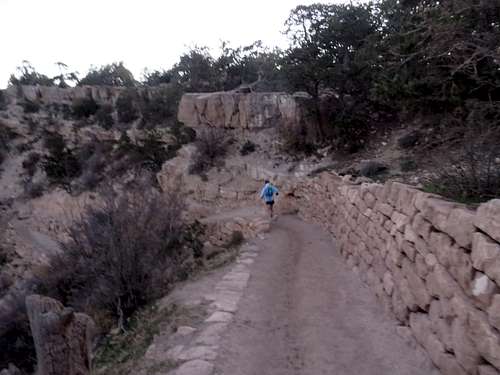
North Kaibab Trail
There are people that would never consider such hike, there are people that would like to complete a RRR but know themselves and their limitations, there are people that attempt the hike but fail due to various factors, and their are folks that complete the trek successfully. Like anything else in life, it is not an enterprise for everyone. Becoming trail tough is a very long process and is only acquired by trail hiking/running and nothing else.![rim rim rim]()
Rim Rim Rim
Rim Rim Rim
There are lots of websites that list various people and their record times. As far as I know, the fastest alleged record is of almost 7 hours for the shortest distance - 42 miles. I have a very hard time believing that someone can actually run at an average of 6 mph on those trails, given the sharp switchbacks, rocky and uneven surface and steepness of the last 5 miles to each rim, in addition to getting and drinking water and eating the energy gels. Being that as it may, congratulations are in order to anyone that manages to complete this trek without pitching a tent, regardless of the time.
A RRR is an arduous undertaking. Months of prior training, both cardio and strength are a must. Shorter hikes on these trails should be completed prior to attempting a RRR. As well, going down from the rim to river and back to rim, although a day-long tough hike, would give one a taste of hiking in this environment. No marathon runner should attempt a RRR only based on the marathon experience. A RRR is a totally different kind of running/ jogging/ hiking. Shorter hikes (10-15 miles) on these trails will give one priceless info about the particularities of hiking in the Grand Canyon.
A good plan to follow, after a few months of training, would be to first hike a rim to river to rim, then a rim to rim and only after having these experiences, a RRR could be attempted. After finishing a rim to rim one should evaluate how it feels and think of what it would take to turn around and continue for another 23 miles. I am sure that not many folks would determin that they have the necessary resources to go back to where they started. There are many things that can go wrong on these trails, from having a bad day, dehydration, heat exhaustion, sprain ankle or broken leg. All these can happen to anyone. But if one lacks physical training, all bets are off. Being able to run at 9 mph for an hour, three times a week will hardly train one for a 50 mile desert trek.
Be prepared and hike smart. There is no satisfaction in dying doing what you like. The success lays with being able to tell the story.
External Links
Grand Canyon Trails Map: http://www.nps.gov/grca/planyourvisit/upload/corridor_map.pdf
Distances & facilities associated with each trail: http://www.nps.gov/grca/planyourvisit/trail-distances.htm
Critical Backcountry Updates: http://www.nps.gov/grca/planyourvisit/trail-closures.htm#CP_JUMP_140503
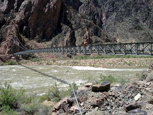
Silver Bridge over Colorado River connects South to North, making it ease for hikers to cross the river. On the other side starts Bright Angel trail and goes right, to South Rim. On this side starts North Kaibab trail and goes to North Rim. Making a left at the other side of the bridge is River Trail that connects to South Kaibab in about a mile from there.