
|
|
Route |
|---|---|
|
|
36.21664°N / 112.05625°W |
|
|
Hiking |
|
|
A long day |
|
|
Strenuous |
|
|
Approach
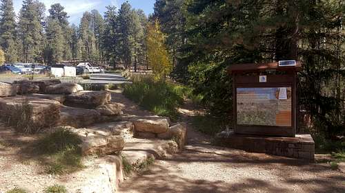
The North Kaibab Trail Head is located 41 miles south of Jacob Lake on Highway 67 (1.5 miles north of North Rim Grand Canyon Lodge). A small parking area offers parking. There are also pit toilets and drinking water here.Transportation is available from the Grand Canyon Lodge (twice each morning; check at the lodge for times and fares) or, for those staying at North Rim Campground, it is a half-mile walk to the trailhead. Hikers on a rim-to-rim hike and who have only one vehicle often use the private Trans-Canyon Shuttle, which provides service between the North Rim and the South Rim daily from May 15 to October 31. The shuttle ride takes about 4 1/2 hours between the rims and costs $90 one way as of 2017. Shuttle schedule: Departs S Rim @ 8AM & 1:30PM; Departs N Rim @ 7AM & 2PM. From October 17 to November 30*: Departs S Rim @ 8AM; Departs N Rim @ 2PM (*Call in reservation strongly recomended, subject to weather related changes.)
North Rim park facilities (lodge, store, gas station) close on October 16. The campground is opened until October 31. Gasoline may be available but nobody's there, breakfast also available at the Lodge on the 16th. Highway 67 remains open to vehicle traffic until winter conditions preclude access. Visitors should be prepared for road closure anytime after October 15, but often Highway 67 remains open into November. Once closed Highway 67 remains so until May 15. It is not possible to reach the trailhead by vehicle before May 15.
![North Kaibab Trail]()
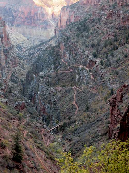
North Kaibab Trail![Coconino Overloor]()
Coconino Overlook![Grand Canyon North Kaibab trail]()
Roaring Springs from North Kaibab trail
 North Kaibab Trail Head | 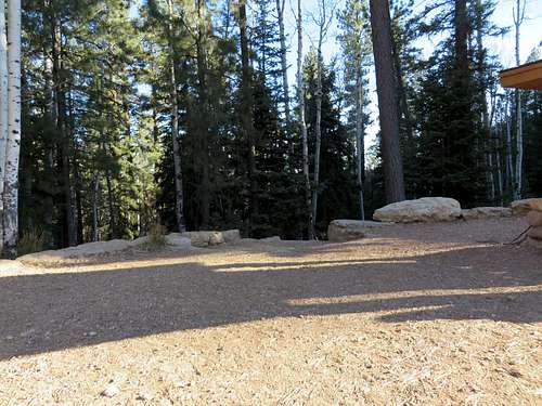 North Kaibab Trail Head |
Route Descripion
North Kaibab Trail
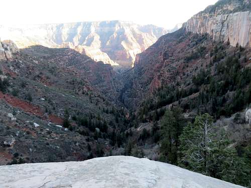
Elevation at trailhead is 8,241 feet. The Colorado River is at elevation 2,400 feet. The North Kaibab is longer and more strenuous than the South Rim trails since it climbs over 1,000 feet higher. It's also less traveled for that reason. The North Kaibab Trail is the only maintained trail into the Canyon from the North Rim. It takes 14 miles from the trailhead to the Colorado River. The trail is well maintained and easy to follow throughout its entire length.
Like any other hike, going down this trail is a pleasure. Coming back up is an entirely different story. It is highly recommended to have a very early start if hiking during the Summer months. Why is it recommended, on every website and by anybody, to start early? I don't know. Logically, when going down the trail is easy, regardless of the heat. When coming up the trail is where the issues come up. If the trail is not hiked out after 4 PM, especially the last 5 miles, there is no benefit of having an early start. If one plans to go only to Supai Tunnel and back, then the best place to catch a sunrise and great lighting for pictures is Coconino Overlook. A daybreak start is a must. Otherwise, if a Rim to Rim is the intent, a late afternoon (any time after 2-3 PM) start is the best option. The stretch between Pumphouse rest area and Phantom Ranch (8.5 miles) is a walk on Mercury in at least 110 temp during summer months. If planing a Rim to Rim, being at the Pumphouse by 5 PM is better than being there at 8 AM.
The top portion, 4.7 miles from the trailhead to Roaring Springs, is very steep and is by far the most difficult section, especially if hiked out. The last 3 miles (going up) of this trail are definitely very strenuous and not for everyone. From Roaring Springs on down to the Colorado River the trail is long (about 9 miles) but not difficult. The descent along the rest of the route is very gradual and hardly noticeable at times. Next mile marker from Roaring Springs is Cottonwood Campground. There is camping available there (permit needed), water and pit toilets. There is also a ranger's residence and an emergency phone. Next attraction down the trail would be Ribbon Falls (1.6 miles from Cottonwood). The falls are however a 1/2 off the main trail. The falls could be considered a half way point from the trailhead to Colorado River. Very beautiful and worth the side trip, Ribbon Falls have no restrooms or tap water. Phantom Ranch/ Bright Angel Campground are 5.6 miles from Ribbon Falls. The trail goes along Bright Angel Creek. The last 3 miles to the river the trail goes through a very narrow canyon called Inner Gorge and nicknamed the Box. Temperatures here can easily go over 100 during the day. It is not a pleasant hike at mid-day, when the Sun beats down mercilessly.
Water and pit toilets are available along the trail at certain intervals (see Water on Trail below)
North Kaibab Distance Breakdown
Coconino Overlook
North Kaibab to Bright Angel Campground/ Phantom Ranch/ Colorado River - 14 miles
North Kaibab trailhead to Coconino Overlook - .7 mile
Coconino Overlook to Supai Tunnel - 1 mile
Supai Tunnel to Roaring Springs - 3 miles
Roaring Springs to Pumphouse Rest area - .7 mile
Pumphouse rest area to Cotonwood Campground - 1.4 miles
Cotonwood Campground to Ribbonn Falls (trail split) - 1.6 miles
Ribbon Falls (trail split) to Phantom Ranch - 5.6 miles
Phantom Ranch to Colorado River - .5 mile
Water on Trail
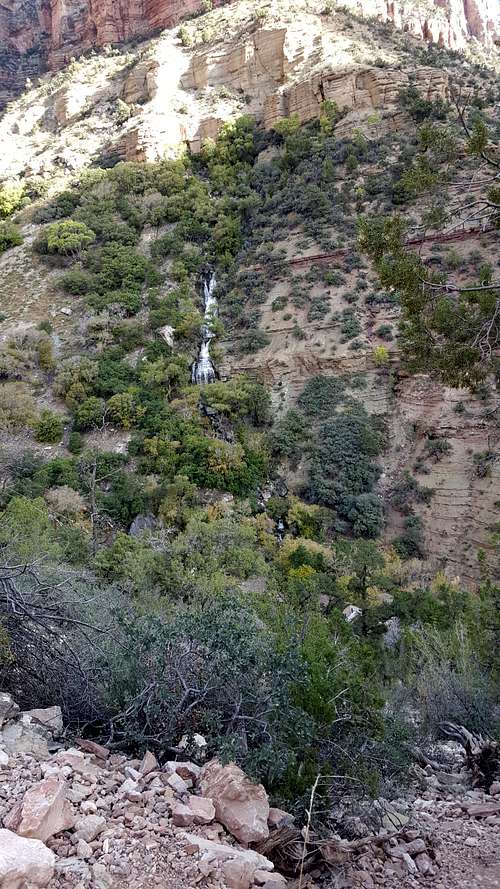
Roaring Springs from North Kaibab trail
On North Kaibab trail there is tap water available at rest areas/ water stations along the trail. Potable water is available at the trailhead, Supai Tunnel, Roaring Springs, the Pumphouse Residence, Cottonwood Campground and Bright Angel Campground. The water however is only available seasonally, mid May to late October. There is water year round only at Bright Angel Campground/ Phantom Ranch. Note that due to occasional, sudden and unpredictable pipeline breaks, water at Bright Angel Campground/ Phantom Ranch is not guaranteed: bringing an alternative form of water treatment, such as iodine tablets or a water filter, is essential.
In addition, any trip inside the canyon should be proceeded by a check of the Backcountry Visitor Website to get the latest updates on the water station closure/ availability (see link below.) Once down in the canyon (about 5 miles from the trail head, there are plenty of creeks and springs where water can be found. It is strongly recommended to treat the water, probably for a good reason. There are hikers who drink water right from creeks and springs. As that may be an option sometimes, during certain times of the year the water is muddy due to various factors. In addition, treating the water is not enough in the rainy season. During the monsoon season, all the water in the canyon is absolutely muddy and totally undrinkable. It has to be filtered first and then treated.
Here is a list of the water stations along this trail and the distances between them (water available only from Mid May to late October:)
North Kaibab Trailhead (the only place with ice cold water on this trail.)
North Kaibab TH to Supai Tunnel - 1.7 miles
Supai Tunnel to Roaring Springs - 3 miles
Roaring Springs to Pumphouse Rest Area - .7 mile
Pumphouse Rest Area to Cotonwood Campground - 1.4 miles
Cotonwood Campground to Phantom Ranch/Bright Angel Campground - 7.2
Phantom Ranch/ Bright Angel Campground – water year-round
History
Built throughout the 1920s to match the quality and grade of the South Kaibab Trail, the present-day North Kaibab Trail replaced an older route infamous for crossing Bright Angel Creek 94 times (the present-day trail crosses only 6 times). Prior to construction portions of the area had trails created by Native Americans, hunting guides, and cattlemen. The first record of people hiking from the North Rim to the Colorado River on what was to be the North Kaibab Trail was 1902 by Francois Matthes and his party of cartographers and geologists. In 1906, David Rust, became the first tourism operator on the North Rim. He would send stock and tourists down the trail to the Colorado River. Once at the river they could cross either in a cable car, or ferried across the river by boat. At that time hiking rim to rim in the Grand Canyon was still not a common hike. Once the South Kaibab Trail was completed in the 1920's the National Park Service decided to create a trail to connect North and South Rims. The Park Service believed creating the trail would attract more tourists and compete with Ralph Cameron's privately controlled Bright Angel Trail. Now there are two bridges that connect the North Kaibab Trail with the South Rim creating trans-canyon routes. The first bridge is the "Black Bridge" completed in 1928, and the second the "Silver Bridge" completed in the late 1960's. The "Black Bridge" connects with the South Kaibab Trail, while the "Silver Bridge" connects with the Bright Angel Trail via the River Trail. Stock and mules only use the Black Bridge to cross the Colorado River. These bridges make it possible for hikers to backpack from Rim to Rim in Grand Canyon.
Red Tape
$30 a car to enter the park as of January 2018 (when I was last there.)
For 2018 there are only four free fee entrance days (compared to 10 in 2017.) These four days are January 15, April 21, September 22 and November 11.
There are also permits required when it comes to camping. (See link below.)
Essential Gear
There are no technical sections along the trail, but one has to be prepared for hot weather. If one is going on this trail in the summer, one would better know what one is getting into. Know your water needs, your limitations and your ability to hike in heat and direct Sun. Bring water, food, sun block, hat, sunglasses, preferably a long sleeve shirt. Heavy duty hiking boots are not necessary. For a few hours hike, regular tennis shoes or summer hiking shoes will be just fine. Trekking poles are of help also.External Links
North Kaibab Trail Map: http://www.nps.gov/grca/planyourvisit/upload/corridor_map.pdf
Critical Backcountry Updates: http://www.nps.gov/grca/planyourvisit/trail-closures.htm#CP_JUMP_140503
NPS North Kaibab Trail page: http://www.nps.gov/grca/planyourvisit/upload/North_Kaibab_Trail.pdf
Backcountry Permits: http://www.nps.gov/grca/planyourvisit/backcountry-permit.htm
Trails Distances and facilities associated with each trail: http://www.nps.gov/grca/planyourvisit/trail-distances.htm