

-
 21167 Hits
-
 87.14% Score
-
 26 Votes
|
|
Mountain/Rock |
|---|---|
|
|
9.54328°S / 77.31755°W |
|
|
Huaraz |
|
|
Mountaineering, Ice Climbing |
|
|
Winter |
|
|
17473 ft / 5326 m |
|
|
Overview
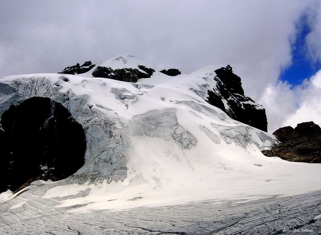
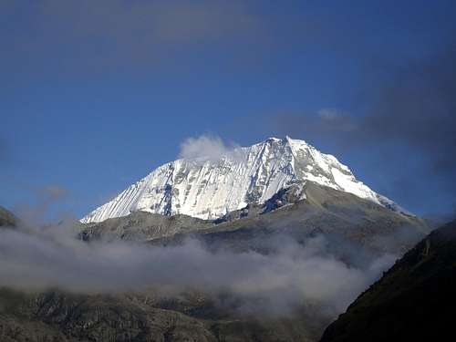
Nevado Maparaju 5326 m
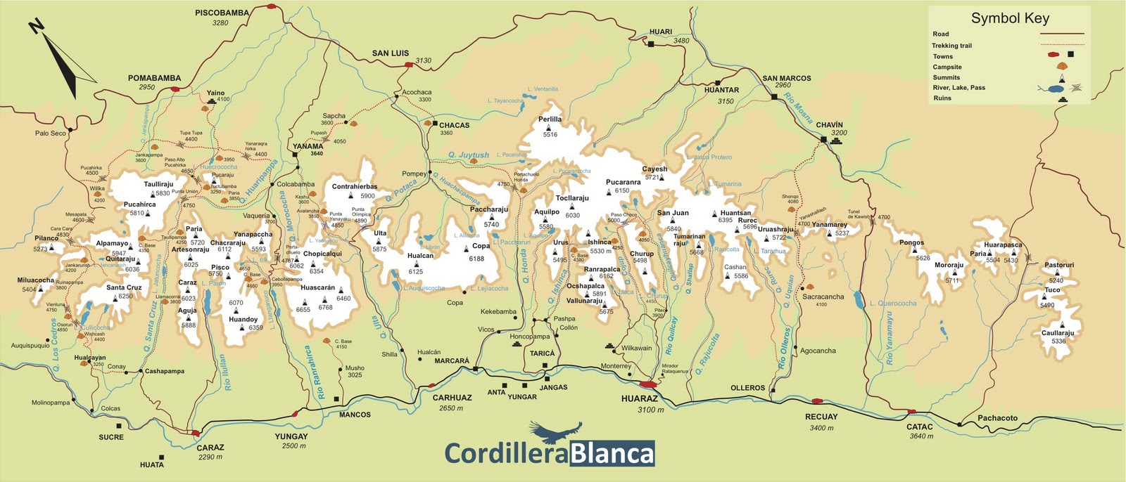
The Cordillera Blanca, with its tropical "nevados" often overcoming the 6000 meters of altitude, among which the Nevado Huascaràn, the highest mountain in Peru with its 6768 m in height, represents an interesting destination for the mountain climbers worldwide. This superb range offers to the mountaineer over 200 peaks of 5000 and 6000 meters in height, with numerous and interesting itineraries of all the difficulties and wonderful landscapes. Aside from the most famous mountains, there are a lot of possibilities for alpinists which prefer less frequented and wilder ascents on less famous "nevados".
Nevado Maparaju is one of these latter, a small but fine "nevado" belonging to the Chinchey Massif, considered as one of the easiest mountains to climb in the Cordillera Blanca. The ascent to this mountain is now considered mid-difficult despite in the past it had always been classified as easy. In fact actually the standard route to summit Maparaju is not so easy and banal as stated. The reason is that in recent times it's more and more frequent the presence of dark ice and penitentes. There are a couple of steep slope to overcome, for which it is certainly advisable to bring some ice screws and pickets.
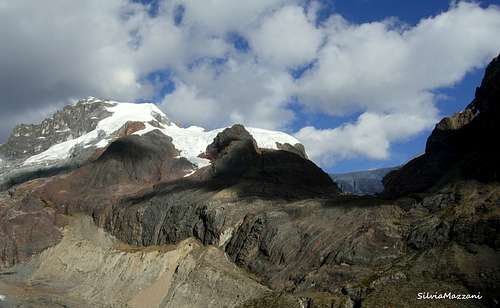
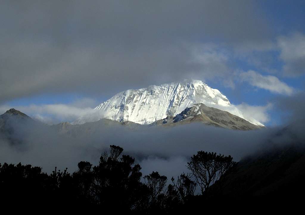
Maparaju is located at the head of the Quebrada Cayesh and it's ascent is an excellent way to acclimatize before climbing other highest or hardest peaks of the same area. The summit offers really breathtaking views to various surrounding mountains, such as the Huantsan, the beautiful Cayesh, Tumarinaraju, San Juan, Andavite and Ranrapalca.
Getting There
Getting to Lima
There are different flights getting to the Aeropuerto Internacional "Jorge Chavez" in Lima, both from Europe and North America, obviously many more from South America. The airport is situated in Callao (about 12 km West to downtown). From there, the bus to Huaraz, the main logistical center for the Cordillera Blanca, takes about 7 hours.
Getting to Huaraz
Huaraz, the capital of the Ancash district and Cordillera Blanca, is a lively and bustling city located about 3000 meters above sea level, which offers several opportunities for accommodation and food, and also easily the possibility to arrange on-site transportation and trekking for people who haven't previously booked any service. Sometimes there are flights joining Lima and Huaraz, but nor regularly. The best way to reach Huaraz is at moment a 6-8 hours trip by bus or private minibus (if you're travelling with a group or an organized expedition). Currently comfortable coaches provide a good transportation from Lima to Huaraz. There are six different bus companies; the best ones are Cruz del Sur, Movil Tours and Ancash Express.
Getting to Pitec
The settlement of Pitec 3850 m is the starting point for the trail to the Maparaju Base Camp. We leave the city of Huaraz to reach Pitec across the villages of Unchus and Llupa.
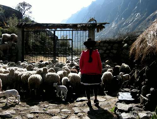
In Pitec there is the headquarter of the Parque Nacional Huascaran where it is necessary to register. Remember to announce your arrival for the opening of the large iron gate that closed the access to the Quebrada Quilacayuanca.
Quebrada Quilcayhuanca trail description
Once past the gate, you enter the wide valley that rises very gently. The trace - not always obvious - keps the right orographic side of the "quebrada". Pass under a beautiful granite tower a few minutes from the start. After 2.30 hours from the start we arrive under the Chopiraju Oeste. Here the valley forks: the Quebrada Quilcayhuanca continues on the left and the Quebrada Cayesh opens on the right.
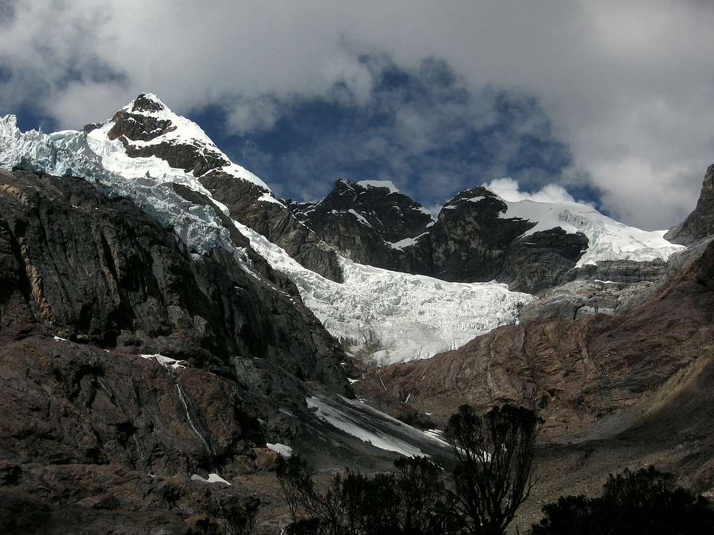
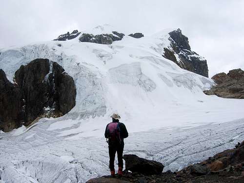
A small bridge allows us to cross the stream and proceed on the right entering the Quebrada Cayesh. We continue to walk up this valley, a little closer than the previous one but still sunny. After about 4 hours from the start we arrive in a wide plain at the head of the valley, an absolutely ideal place to put the Base Camp.
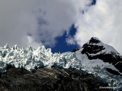
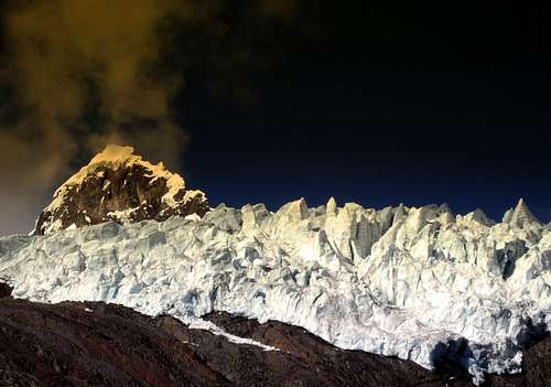
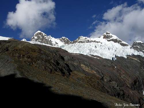
The site is wonderful, enclosed by a barrier of reddish rocks, above which there is a magnificent suspended serac. Beyond the serac a little to the left it stands the Nevado Cayesh, one of the myths of the Cordillera Blanca due to the extreme difficulty of its routes. Further to the right there is the beautiful Milpocraju and finally to the right the Nevado Maparaju to close the valley. On the opposite side, the Ranrapalca appears farther away, while the three Chopiraju aka Andavite rise on the orographic right side of the valley.
Maparaju Normal route
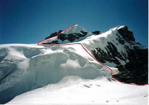
South West standard Route
Summit altitude: 5326
Difficulty: Alpine PD+, 45°
Difference in level: about 1000 m. from Base Camp at the head of Quebrada Cayesh 4300 m
Exposure: SW
First ascent: J. de Paz and L. Stewart July 16th, 1960
Starting point: Head of Quebrada Cayesh 4300 m
First Ascent: J. de Paz and L. Stewart July 16th, 1960
Route report
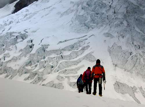
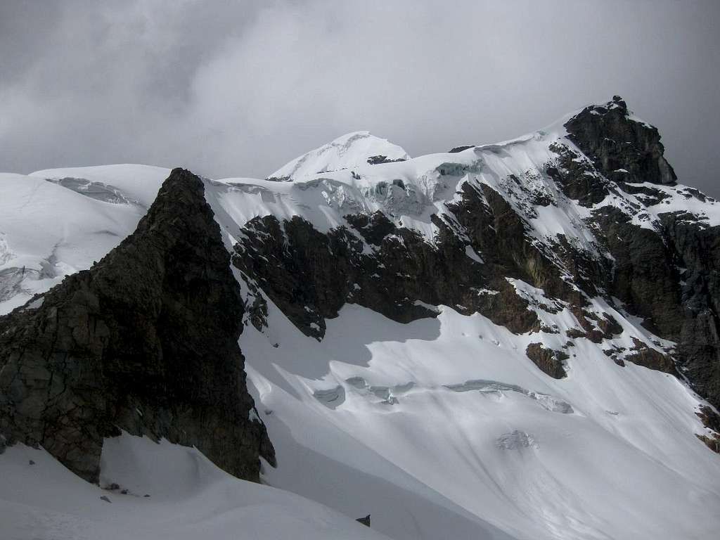
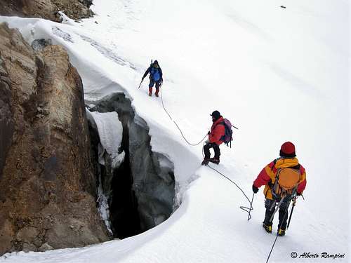
From the BC, take a not very obvious old mule track with cairns on the right of the camp (orographic left), that goes up with several hairpin bends the steep slope of the right side of the valley (orographic left) with several hairpin bends under some rocky walls. After a very steep section gain the upper part and along the moraine reach the front of the glacier with different "penitentes".
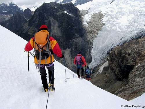
Above the glacier it opens the Abra Villon Col, an ancient passage between the East and West sides of the Cordillera Blanca. After having rope-up, enter the glacier heading towards Maparaju just clearly visible from here. The flat glacier (perhaps even slightly downhill) leads to the base of a steep, often icy slope situated on the left of a spur of reddish rocks.
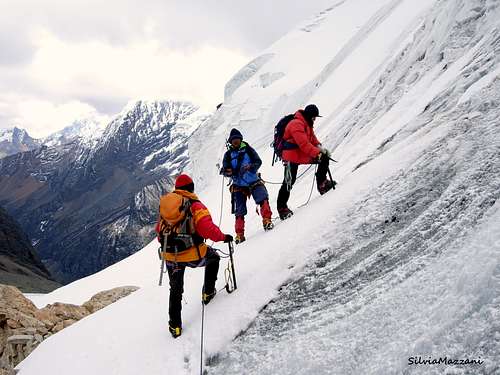
At the end of this steep slope it follows an almost flat stretch heading towards a rocky triangle. We skirt it on the left along a new steep snow slope, which can possibly be avoided by going further down. To the left we begin to climb the steep summit slope directly crossing three crevasses.
The slope leads to the summit ridge on the right of the culminating point, which is reached with a short traverse to the left on the ridge.

Descent: reversing the same route.
Essential gear
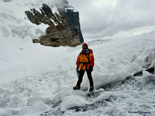
Rope, crampons, long axe, some pickets and 1-2 ice-screws
Climate and conditions
The climate of the Cordillera Blanca is influenced both by the dry air coming from the Western deserts and by the wet air coming from the Eastern amazonicos forests. From May to early September, Cordillera Blanca has some periods of clear weather, expecially in June and July, generally with an alternation of few days of bad weather. During these days the mountains can get some amounts of snowfall. Sometimes August may be a month of change, expecially in the second half, with possible afternoon storms. Being the "Blanca" located in the Southern hemisphere, North and East faces get good conditions first. Cordillera Blanca is suffering because of global warming, with its "tropical" glaciers melting at a rate even higher than the global average. Since Peru is located in the southern hemisphere, the walls that receive the most sun are the northern walls, contrary to what happens in the northern hemisphere. These walls offer good conditions of hard snow during the first part of the day. The Southern walls are the equivalent one of the alpine North faces. The snow receives very little sun reason why almost never it gets to consolidate. To form separated runners by snow edges that sometimes reach even the vertical. The securing is problématico. The cornices may become very great and hang sometimes to both sides. Most of the edges they have cracks. It is very difficult to determine the present state of the itineraries. The stranger and the improvisation are basic in andinismo.
Red Tape
Maparaju and the entire Cordillera Blanca are located within Parque Nacional Huascaràn, one of most spectacular high mountain area in Perù, established in 1975 and acknowledged as an Unesco World Natural Heritage in 1985. Unesco Link here: Unesco info.
The Huascaràn National Park is administered by the Instituto Nacional de Recursos Naturales (INRENA). An entrance fee is due. In 2011, the fee for the Huascaran National Park was 65 Soles for 21 days. Since 2011, officially nobody is allowed to climb without a Mountain Guide, except for the persons who are members of a Mountaineering Association. In this case, the permit can be obtained at the National Park Office in Huaraz, showing the Alpine Club card.
Always be respectful of this fragile landscape. Carry-out everything you bring in and any litter that you carry-in or that you find on the routes and help to conserve the beautiful landscape! Take care of nature as usual in the natural sites and particularly within the boundaries of all the natural parks.
Maparaju and the entire Cordillera Blanca are located within Parque Nacional Huascaràn, one of most spectacular high mountain area in Perù, established in 1975 and acknowledged as an Unesco World Natural Heritage in 1985. Unesco Link here: Unesco info. The Huascaràn National Park is administered by the Instituto Nacional de Recursos Naturales (INRENA). An entrance fee is due. In 2011, the fee for the Huascaran National Park was 65 Soles for 21 days. Since 2011, officially nobody is allowed to climb without a Mountain Guide, except for the persons who are members of a Mountaineering Association. In this case, the permit can be obtained at the National Park Office in Huaraz, showing the Alpine Club card. Always be respectful of this fragile landscape. Carry-out everything you bring in and any litter that you carry-in or that you find on the routes and help to conserve the beautiful landscape! Take care of nature as usual in the natural sites and particularly within the boundaries of all the natural parks.
When to Climb
The climate of the Cordillera Blanca is influenced by the dry air coming from the desert zones to the West and by the humid air of the amazonicos forests to the East. The dry season in Cordillera Blanca goes from middle May to the early September, coinciding with the local winter, being the Cordillera Blanca situated in the southern hemisphere. Anyhow, still there is usually too much snow dust in May and June for the ascents, the months of July and August are more indicated. In this period generally there is an alternation of several days of good weather with one or two of bad weather. Even so, the Boy has tendency to disturb this regularity. Usually the rainy season starts in early September.
Accomodation
There is a wide choice of options for accomodation and meal in Huaraz.
Meteo
Weather Forecasts
Meteo Huaraz - Ancash region
Miscellanous info
The Quebrada Quilcayhuanca and Cayesh are ideal valleys to become aclimated itself and the access is rather short and easy. The camping base allows to acced to several wild and interesting summits.
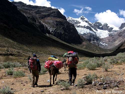
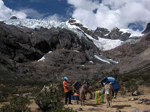
Arrieros
The animal of load commonly used in the Cordillera blanca is the donkey. Normally it can load with 30 or 40 kg, but this depends mainly of his master.
Although the approach to the Maparaju Base Camp usually does not take more of a day, it's worth worth getting served by of these animals.
Guides
Peru is at the moment the only country of Latin America with an Association of Mountain Guide recognized by the UIAGM. The house of of guide of Huaraz is closely together of the Seat of Arms. There you will be able to know the condition of the itineraries. Also it is the best place to find carriers if you do not wish to pass through an agency.
Rescues
The mountain rescues have been reorganized and are responsibility of the police now. It is not necessary to forget, nevertheless, that the helicopters never raise over the 4.500 meters and that therefore the rescues can take enough.
 |
 |
 |
 |
 |
Guidebooks and maps
Guidebooks


- "Classic climbs of the Cordillera Blanca – Perù" by Brad Johnson, 2009 revisited edition - in English
- "The Andes - A guide for climbers" by John Biggar, 3rd edition, 2005 - in English
- "Escaladas en los Andes" by Juanjo Tomé Ed. Desnivel, 1999 - in Spanish
- "Climbs of the Cordillera Blanca of Perù" by David Sharman, 1995 - in English
Maps
Alpenvereinskarte 0/3a Cordillera Blanca Süd (Perú) 1:100000
External links
- Unesco World Heritage
- Parque Nacional Huascaràn
- Andes Handbook - a site with complete pages about the mountains of the Andes