

|
|
Mountain/Rock |
|---|---|
|
|
9.10204°S / 77.61998°W |
|
|
Download GPX » View Route on Map |
|
|
Mountaineering |
|
|
Winter |
|
|
21834 ft / 6655 m |
|
|
Overview
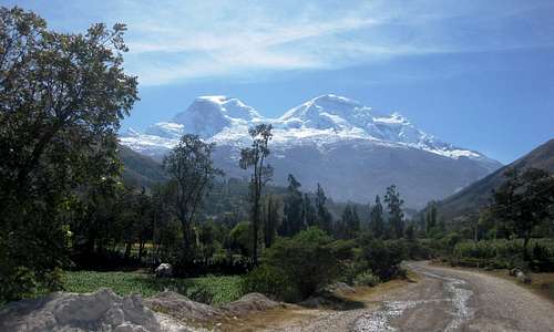
Huascarán Norte and Sur from the southwest, from the road to Musho
The Cordillera Blanca lies in the Ancash region of Peru. Within the region, the province of Yungay hosts the two highest summits of Peru, the twin peaks of Huascarán: Nevado Huascarán Norte, and it's slightly higher brother, Nevado Huascarán Sur. Since these full names are rather long, "Nevado", meaning snowy peak, is usually left out.
Most visitors only see the pair from the western side, the Rio Santa valley aka the Callejón de Huaylas, but some of the best views are from the nearby surrounding valleys and the slopes of the mountains around it:
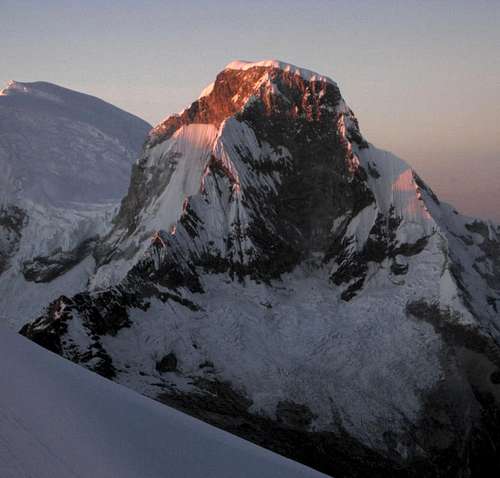 Huascarán Norte from Pisco, to the North | 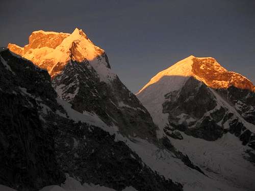 Huascarán Sur and Norte from Chopicalqui high camp, East of Norte, Northeast of Sur | 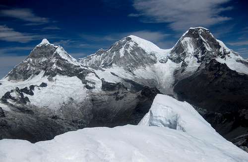 Chopicalqui, Huascarán Sur and Norte from Yanapaccha, to the NNE |
Although it's the second highest mountain in Peru, Huascarán Norte is sadly underrated. I blame two obvious reasons for that. First of all, it's real close to the highest one. The second reason lies in the name: it suggests that it's 'only' a subsidiary. However, with the saddle between the two at 6010m, Norte has a quite respectable prominence of 645m. If only it had a different name, nobody would consider it merely a subsidiary summit anymore. In fact, according to [1], the local name is Matararaju, but everybody I met called it Huascarán Norte.
The first ascent of Huascarán Norte was on September 2, 1908, by Annie Peck with the guides R. Taugwalder and G. zum Taugwald. At the time she thought it was higher than Sur, and in fact the highest mountain in South America. A bit of controversy ensued whether she had really climbed it[2], but I believe she did.

Huascarán map
Getting There
Lima international airport has direct connections to a few major cities in Europe and North America, and many more in South America.Huaraz is the capital of the Ancash region, and by far the largest city. From Lima, you may be able to fly to Huaraz airport, which lies north of Huaraz itself. Occasionally, there are commercial flights to and from Lima, but usually the service doesn't last. In 2011, I saw an ad that there would be regular flights again, starting in a few days, but I think it didn't take off. However, when Huaraz keeps growing, at some point I expect there to be a regular service.
Most travelers come to Huaraz using one of the long distance bus services. Thanks to improving roads, it's about 7 hours from Lima. And although, officially, there is a luggage weight limit on the buses, the surcharge is low, and the weight is not checked very rigorously anyway.
Two good bus companies are Cruz del Sur and Movil Tours.
From Huaraz to Musho by taxi takes about 1.5 hours. Prices are not set: to Musho we paid 200 Soles (70 US $), but the return trip was only half that. A much cheaper option is to take a collectivo to Mancos and a taxi from Musho from there. It doesn't take much longer, but keep an eye on your gear.
The Approach

The trailhead in Musho (-9.1674,-77.6709)
These mountains are big! From down in the valley, it's more than 4000m up, and from the trailhead at Musho it's still some 3600m to the summit of Norte! Needless to say, for all but a few exceptional people, it takes a couple of days to climb them. If you're well acclimatized and the weather is good, count on five days.
Either in Huaraz[3] or in Musho[4], you can hire mules and porters, who can carry gear up to Campo Dos for 30 US $ per day (2011). If you want a guide, you'll have to arrange that in Huaraz. The normal rate for Huascarán is 130 US $ per day (2011).

The refuge (-9.1387,-77.6353)

Rock slabs above base camp
From Musho, there are two trails to Refugio "Don Bosco" Huascarán (4650m) (-9.1387,-77.6353). The older, more northerly one passes 'base camp' at around 4200m. Most commercial expeditions spend a night there. The views over the valley and towards the Cordillera Negra are fine, but there are also a lot of small biting insects. If you're already acclimatized, you'll want to skip base camp and continue to the refuge the same day. It's 4 to 5 hours from Musho with a light pack.
After base camp, the terrain gets a bit more difficult. Mules can go no further. Immediately past base camp, there are a few meters of easy scrambling. After that, it's mostly walking territory again, over rock slabs with a few more short sections of easy scrambling higher up. Generally speaking, the route traverses the mountain towards the south east while gaining altitude. Cairns mark the way and in decent visibility, you should be able to see the next one.
The newer, more southerly route is actually easier, as there is no scrambling involved. The two routes join a few minutes before the refuge. About half way, there are plenty of good camp sites - but again with those unpleasant insects. Although mules can follow this trail all the way up to the refuge, the locals have decided not to offer mules on this track, because that would mean less money for porters carrying gear from BC to the refuge. Not everybody agrees, but that's the way it is.
Overall, the newer track, while there is no scrambling involved, is somewhat steeper and therefore shorter. Perfect for a fast descent.
If the refuge is closed, or you don't want to stay there, there are plenty of good camp sites near it as well as higher up, all the way to the edge of the glacier, some 300m higher.
The route from Musho to Campo Dos and back. Ascent by the northern approach route, descent by the southern one. For the original version of this trail, see Huascarán at EveryTrail. Recorded by Lyngve Skrede.
The Normal Route
From the refuge to Garganta

The edge of the glacier

Campo Uno 2011 (-9.129,-77.624)

Campo Dos 2011 (-9.116,-77.618)

the icefall near Campo Dos
The icefall itself has been far too wild to tackle directly for quite some years now, and is bypassed on the right hand side, on the lower slopes of Huascarán Sur. At first, the route negotiates a way through an area with lots of crevasses. There might be some steep sections, but in 2011, it wasn't very difficult and one ice axe was sufficient. High up, a traverse to the left leads to the icefall just below the col. The traverse is easy but dangerous, because you'll have to pass two active avalanche zones.
The col itself can be very windy, so it's not a good idea to camp there. The best place for Campo Dos will be in a somewhat sheltered place below the col, but where exactly will of course be different from year to year. As I found out, despite the big icewall sheltering us from the wind, it was still a very windy place.
Between Campo Dos and Garganta proper, there are a couple of large crevasses. It can take a bit of searching to find a way across if there is no trail.
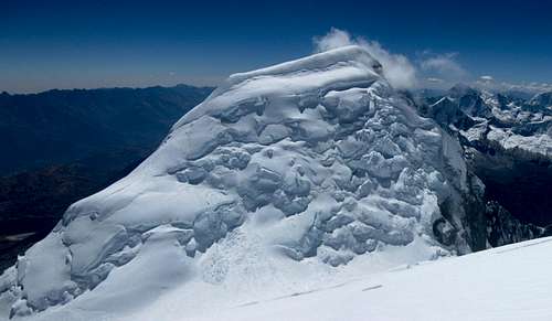
From Garganta to the summit
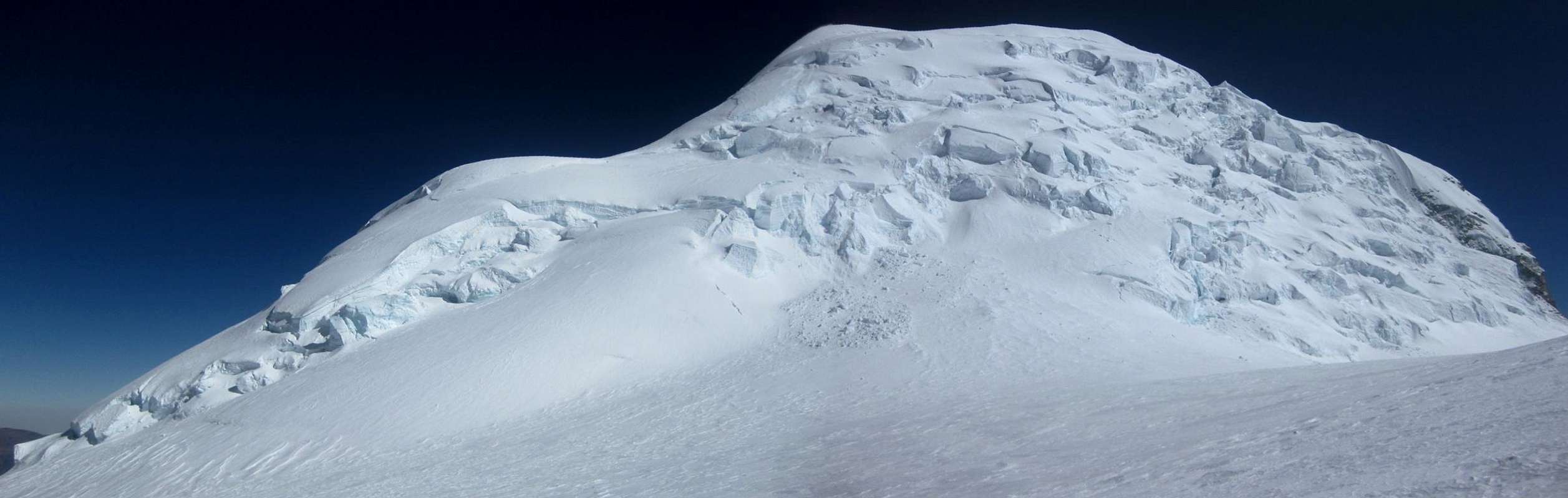 Huascarán Norte panorama from the SE, from Garganta. The south ridge is on the left. What appears to be a flat summit ridge, is still ascending, Huascarán Norte panorama from the SE, from Garganta. The south ridge is on the left. What appears to be a flat summit ridge, is still ascending,and the summit is on the right. The higher part of the mountain is clearer from high on Huascarán Sur - see below. |
Huascarán Norte from high on Huascarán Sur

Finally, a passage

The crux
There were a few more steep parts higher up, but not quite the same exposure. Near the summit there was an easy to cross bergschrund, and I discovered some hidden crevasses. I would rate the route AD- this year, and slightly easier than Sur.
Notes on gear
Climbing solo, two ice tools are indispensable. When following, you might be able to manage with one, but two are still highly advisable. Strong winds are not uncommon, and I was happy that I could borrow a pair of goggles to protect my eyes.
Other Routes
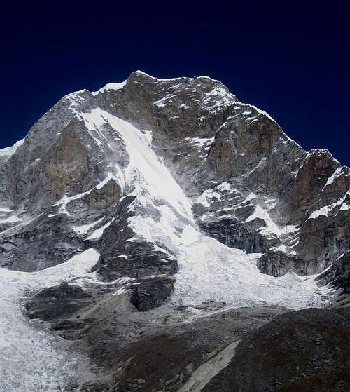
The NE face of Huascarán Norte. The route starts by following the long glacier ramp, then crosses the rock band high up. With receding glacier cover, it won't get any easier.
Accommodation and Camping
Huaraz has lots of accommodation options, in all price ranges. A relatively cheap one is Edwards Inn. Its best asset is its owner, Edward. As a former mountain guide, he has an almost encyclopedic knowledge about the mountains, keeps himself informed about the conditions, and is extremely helpful. He speaks excellent English.Yungay offers only basic accomodation, but I warmly recommend Hostal Gledel - clean rooms and very friendly and helpful people. On request, they'll serve a fine dinner too.
Musho is small, but has a few very basic places to stay, and you can get a decent meal there as well.
On the mountain, camping is free. The refuge serves meals, and you can get a dorm bed for the night. For Peruvian standards, prices are high - 12 US $ for a bed for example - but on the plus side, there is hot water, usually.
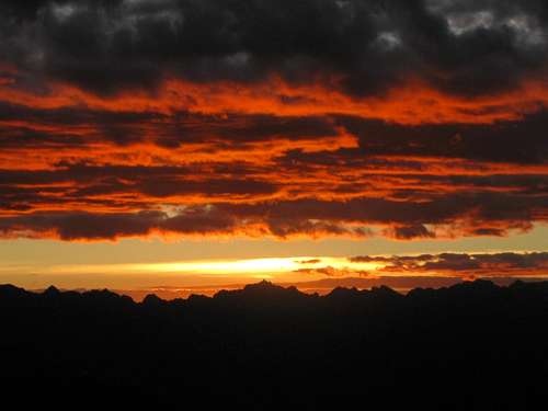
Sunset over the Cordillera Negra, from the refuge
When to Go
Although Peru lies on the southern hemisphere, it's not far from the equator and temperature differences over the seasons are relatively small. However, as the seasonal weather patterns see significantly less precipitation by late fall through early spring, that's the best time of year to go. In winter you can have long periods without any precipitation, and days that typically start with clear skies, followed by buildup of clouds covering the high summits, then clearing again later on. For climbing, that means that you want to aim to be on the summit early in the morning. For camping, you can almost count on many beautiful sunsets from high camps with a free view to the west.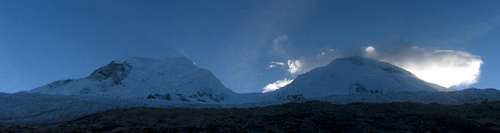
7 am: early clouds on Huascarán
Early on in the dry season, chances are that some of the slopes have unconsolidated powder left from the last snowfalls. Amazingly, unconsolidated powder sticks to 60° slopes! By the end of June, the thaw-freeze cycle of the strong sun and cold nights will have transformed most of it into a stronger and safer surface. Steep southern faces, seeing less sun, are the last to consolidate.
Strong winds can happen at any time of the year, especially on the highest mountains like the Huascarán summits, but are somewhat more likely by the end of the season. All that combined, that makes July the best month for climbing, closely followed by August and June.
Red Tape
The Cordillera Blanca is a national park, named after its highest mountain: Parque Nacional Huascarán. If you want to visit, you need a ticket. It's 65 Soles, in 2011. On the official ticket it says "Valid for 7 days", but there seems to be some confusion about that. An experienced mountain guide told me that it was not correct, even though the ticket says so, and that it was valid for a month. After that, I only bought a new ticket when my old one was a month old.More importantly, if you want to climb any mountain in the Cordillera Blanca, you must either go with a guide, or get written permission from a park official. I found the people at the National Park office in Huaraz always very friendly and helpful in obtaining one.
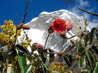 Alpine flowers along the road to the Chopicalqui trailhead, with Huascarán Norte behind
For the record, on two trips to Huascarán, I was never asked to show my ticket or permit, but on several occasions near the trailheads to other mountains I was. So, best to be prepared and have that paperwork in order.
A History of Distasters
On 10 January 1962, early in the morning, a big ice cornice broke off, high on Huascarán Norte, triggering an enormous avalanche. It rolled down the western slopes, covering the fertile valley. It took 10 miles to come to a halt, wiping several small villages on the outskirts of the nearby town of Yungay off the map and killing 4000 people in the process. See this BBC news article.On 31 May 1970, a earthquake shook the north of Peru, causing widespread damage and killing tens of thousands. Most of the buildings in the Ancash district capital of Huaraz were destroyed, but it's been rebuilt, and is now a vibrant city, thriving on a mix of mining, agriculture and a bit of tourism - and probably also a bit on the cocaine trade, but that's hard to capture in the official statistics. Still, it's safe to walk the streets at night.

Yungay Memorial
Although the center of the quake was in the Pacific Ocean, well to the west, it had a devastating effect on Yungay: the quake triggered an even bigger avalanche on Huascarán Norte than in 1962, and it covered the town, killing over 20,000 people. Almost all of the inhabitants died. Today, the top of the church tower can still be seen, sticking out of the ground. Ironically, the only survivors were the handful that fled to the cemetery hill.
Since then, the town has been rebuilt - about two kilometers further away from the mountain - but I found the atmosphere a bit subdued. At the cemetery, a memorial with a big Jesus statue faces the mountains, serving as a sobering reminder.
External Links
Yungay ProvinceUSGS Report of the 1970 earthquake
Maps, Books and References
The best map is the Alpenvereinskarte 0/3a Cordillera Blanca Nord (Perú), 1:100000.[1] The Andes - A guide for climbers, by John Biggar. 3rd edition, 2005. ISBN 0953608727
[2] Yuraq Janka: Cordilleras Blanca and Rosko, by John F. Ricker. 1977. ISBN 9780930410056
[3] Casa de Guias in Huaraz is a good source of information and can help you finding a guide, porters, et cetera. Alternatively, there are many outfitters in town, happy to provide anything from transport to the trailhead to a completely organized climb.
[4] There are a few small agencies in Musho that can provide mules and porters. I was happy with the services provided by
Agencia de Viajes Turismo Callejon de Huaylas
Abraham F. Cordero Villar
Av. 5 de Julio 504
Musho - Yungay
943034994
[5] Classic Climbs of the Cordillera Blanca, by Brad Johnson. 2009 revised edition. ISBN 9780975860618
Jesus Malverde - Jan 11, 2013 9:01 am - Hasn't voted
Interesting Read: Annie PeckAnnie Peck's 1911 book "A Search for the Apex of America, High Mountain Climbing in Peru and Bolivia Including the Conquest of Huascaran, With Some Observations on the Country and People Below" is worth a read if you are going to the area or climbing Huascarán Norte/Sur.
rgg - Jan 15, 2016 5:39 pm - Hasn't voted
Re: Interesting Read: Annie PeckI think that that reprint is too expensive, but I just found an online version of the original in the Open Library, so I'll certainly check it out now!
petr - Dec 4, 2015 10:10 am - Hasn't voted
1970It is perhaps worth mentioning that the whole Czechoslovak expedition fell victim to an avalanche at the lake Llangunuco in 1970. All 14 climbers died. Ironically, they were originally planning to climb Mt.McKinley/Denali but it was deemed politically unacceptable by the communist regime (not even two years after Soviet-led military invasion of my country). Huascaran was then an alternative solution. There is a simple monument on the place.