
-
 14295 Hits
-
 78.67% Score
-
 10 Votes
|
|
Mountain/Rock |
|---|---|
|
|
48.12254°N / 121.28605°W |
|
|
Snohomish |
|
|
Hiking, Mountaineering |
|
|
Spring, Summer, Fall, Winter |
|
|
6343 ft / 1933 m |
|
|
Overview
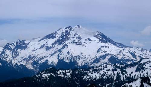
Glacier Peak seen from the summit

Starting Elevation:1850 feet
Summit Elevation: 6343 feet
Total Gain: 4500 feet
Round Trip Distance: 15 miles
"Zi Iob" is a Saukme Indian phrase for the immediate area surrounding Round Lake, and means "mysterious people" in English. Between 1986 and 1988 there was some dispute between the Washington State Names Authority and the USBGN about the naming of Zi iob Peak. This is why some maps indicate it's location while other maps show only a high point on Lost Ridge. In any case, the summit is easy to attain but lengthy on the approach.
For those who enjoy an isolated wilderness experience and like to bag peaks that are not often done, a combination of Zi iob and neighboring Breccia Peak might be just what the doctor ordered. If the 17 miles for both peaks id too much for one day, try an overnight at Round Lake or Sunup Lake. These are both stunningly scenic alpine destinations. As with most of the cascades in the 6000 foot range, expect abundant residual snow in spring and fantastic colored slopes in the fall. Marmots and Bears frequent Lost Ridge and the surrounding area but don't expect to see a cougar because they watch you, not the other way around.
Getting There
From Darrington drive south on the mountain loop highway 16 miles to the North Fork Sauk River Road number 308. This road may now be marked as Forest Road 49. It will be the second road on the left about a mile or two past the Mount Pugh trailhead road. Turn left onto the road and drive 3 miles to a small parking lot on the left about big enough for 4 cars. Here you will find the Lost Ridge Trail and sign board.As an alternative driving from the south end of the Mountain Loop Highway through Granite Falls is an option although I’m not sure about the mileage between Granite Falls and the turn off. This will add considerably to the amount of rough rode to be traveled. Watch for killer potholes either way.
The Route
Lost Ridge Trail
Starting from the parking lot at 2000 feet, the trail doesn’t gain much elevation for the first half mile as it follows the often-damp fern and brush covered valley floor. You will know you have reached the base of Lost Ridge when the incline increases and the undergrowth thins out. For the next two and a half miles the trail is well graded and follows switchbacks up to Bingley Gap (4425 feet) and the top of the ridge. Occasionally openings in the trees will reveal massive Sloan Peak towering over the valley. At Bingley Gap there is a great view of Mount Pugh and White Chuck Mountain to the north.

From Bingley Gap some head west for Spring Mountain. For Zi iob Peak, follow the trail another 2 miles east staying on or near the top of the ridge. You will pass through some open sloping meadows where views to the south become impressive. You will come to a fork in the trail around 5500 feet. The right fork continues along Lost Ridge toward the now non-existent Kennedy Hot Springs. The left fork will take you to the Round Lake overlook saddle at 5550 feet within a few minutes. It's worth a look if you haven't seen Round Lake before. From the saddle there is a trail leading down to Round lake and this is a good place to camp and swim. Backtrack to the fork and continue east on the main trail along Lost Ridge. Approximately 7 miles from the trail head, cut north ascending an easy slope to the top of Lost Ridge and follow this for a few hundred yards up to the semi-forested summit. Beware of a major overhanging cornice during winter and spring. After your summit bid, make sure you explore the mysterious green monolith. I'm guessing it's some sort sensor device for seismic activity or the like.
UPDATE: As of October 2015, the green monolith has been replaced with a newer facility.
Current Road Conditions
Darrington Ranger Station
1405 Emens Avenue North
Darrington, WA 98241
(360) 436-1155
Special thanks to Redwic for his help in gathering accurate information to build this page.
Red Tape
A Northwest Forest Pass is required at the trail head. You would hope that rangers don't patrole this area but I have gotten a ticket at the trailhead before. Also, make sure to bring an ice axe, gaiters and appropriate snow gear if you go before July.The Summit
External Links
A photo gallery from Cascadedream's 2006 tripCurrent Road Conditions
Darrington Ranger Station
1405 Emens Avenue North
Darrington, WA 98241
(360) 436-1155
Special thanks to Redwic for his help in gathering accurate information to build this page.
geosean - Oct 7, 2009 12:48 pm - Hasn't voted
E vs. WIn the “route” section right after you reach Bingley Gap you have East and West mixed up in reference to Spring Mtn. and the ridge. Just wanted to let you know. By the way, is Spring Mountain worthwhile enough to have a page of its own? I’ve never been there
gimpilator - Oct 7, 2009 6:16 pm - Hasn't voted
Re: E vs. WThank you for this correction. Unfortunately it's not the first time that I've gotten my directions crossed in haste. As far as Spring goes, that was my original objective and when it didn't work out I decided to try for Zi iob. Spring is definitely worthy of a page. We followed the ridge top until it became too technical. I later found out that we should have traverse on the steep south side below the cliffy section. I see that you have done a lot of the peaks that I like and also a few I plan to do in the future. How did you like Larrabee? One more question. I noticed that some of your Baker photos were from an OC trip. Do you work for them? I used to guide Baker trips for the OC a couple years ago. Adam
geosean - Oct 8, 2009 6:21 pm - Hasn't voted
Re: E vs. WLarrabee was great, I have always wanted to do it but i was never able to drive all the way to twin lakes cause i had a car, just this year i got an SUV, so that was the first place i went. the hike in is really short so the trip feels like its all climb, its great. In regards to my Baker climb in '08 i just went on an OC trip, i would have loved to work there when i was a student but i didnt have enough experience to be a guide. I looked Spring mountan up in the Beckey guide, amazingly he didnt mention it! this is the first time i have ever not been able to find at least the mention of a peak by Beckey. do you have any idea what kind of rating the climb would be? im pretty much limited to class 3, maybe 4 if i had a partner, but i would be interested in Spring.
gimpilator - Oct 9, 2009 2:42 pm - Hasn't voted
Re: E vs. WThe correct route will not exceed class 3. I have a friend who did it about ten years ago. He goes by the name of magellan here and on nwhikers.net. I asked him for details about the route but he doesn't recall the finer details. You might find these two trip reports helpful although the second stays on the ridge top which is not the easiest way. http://www.nwhikers.net/forums/viewtopic.php?t=16970 http://www.nwhikers.net/forums/viewtopic.php?t=7407
geosean - Oct 9, 2009 9:51 pm - Hasn't voted
Re: E vs. Wthanks!