
|
|
Mountain/Rock |
|---|---|
|
|
48.18955°N / 121.25933°W |
|
|
Snohomish |
|
|
6324 ft / 1928 m |
|
|
Overview
When you think of a peak with a name like "Meadow Mountain", you may have images in your head of frolicking towards a rounded summit through fields of grass and flowers - much like the opening scene of "Sound of Music". Sorry to disappoint any Julie Andrews fans, but Meadow Mountain is actually a steep, rocky summit on the high alpine ridge between Glacier Peak and White Chuck Mountain. There is actually plenty of meadowy frolicking to be done enroute to Meadow Mountain - while the climb can be done in a day (a long day), it would be much more enjoyable to spend two or three days on this incredibly scenic ridge. Until recently, Meadow Mountain was very difficult to access, thanks to washouts on surrounding forest roads. As of 2011, however, the road situation has been greatly improved, and Meadow Mountain is once again open for business.The Meadow Mountain Trailhead can be accessed in two different ways. The first option would be to follow the Mountain Loop Highway south from Darrington for nine miles to FR23 (I'm told this road is once again open, I have not confirmed it with my own eyeballs). Follow FR23 six miles to Rat Trap Pass Road (FR27). Follow FR27 2.4 miles, and find the trailhead on the right. Option two (for those coming from the north) is to follow the Suiattle River Road (FR26) for ten miles to FR25. After 3.5 miles on FR25, turn onto FR27, and follow it seven miles to the trailhead on the left. Unfortunately, getting to the actual Meadow Mountain Trail requires a five mile road walk from this "trailhead". A mountain bike might help on this part, but be prepared for some hill climbing. Once you have made it to the end of the road, find the "real" trail on the left side of the road. The trail will very quickly leave the forest behind, and after approximately two miles, you will find yourself at the crest of the ridge. Here is where a 0.7 mile side trail will take you down to Meadow Lake. This would certainly be a good camping option, but it would add several hundred feet of elevation gain to your trip. As you continue east, the views will go from good to amazing - in late summer, the wildflowers will be putting on quite a show.
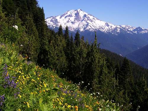
Glacier Peak from the Meadow Mountain Trail
After about four miles on the trail, you will arrive at the crest of Meadow Mountain's south ridge, at an elevation of 5800' (about 0.7 miles S/SW of the summit). The Cascade Alpine Guide recommends following the ridge to the summit from this point. To me, the ridge crest looked a little brushy, and necessitated climbing over a 6050' high point on the ridge. I elected to continue down the trail to an elevation of about 5500' in a small basin. From here, I scrambled up to the 5850' saddle about 0.3 miles S/SW of the summit. I can't say for certain that this option is better, but it worked well for me. After a short scramble, you will find yourself on a 6100' high point about 0.2 miles south of the summit. From here, you will have a good view of your objective.
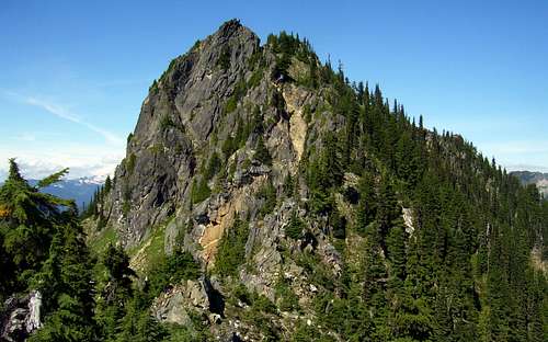
Meadow Mountain from the south
Continue scrambling along the south ridge, staying close to the crest or slightly to the right (east) side of the crest. As you near the summit, you should find yourself on a brushy knob immediately east of the summit. Cross a small notch to the final summit block, where 20' of class 3-4 climbing will put you on the top. The exposure is not too bad, but a short length of rope might help if one is skittish about the downclimb.
Views on the top are outstanding, with Glacier Peak dominating the scene. There is also a nice view of Emerald Lake. This would be a possible camping destination (via Diamond Lake), albeit with a substantial elevation penalty.
Meadow Mountain summit pano
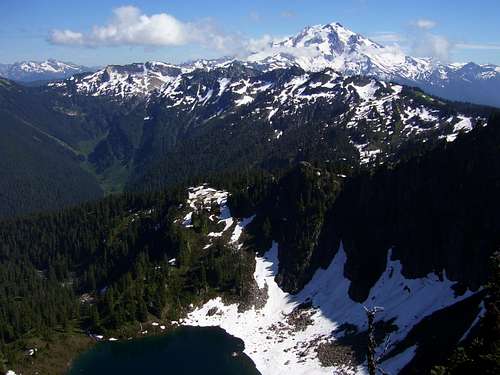
Glacier Peak and Emerald Lake from Meadow Mountain
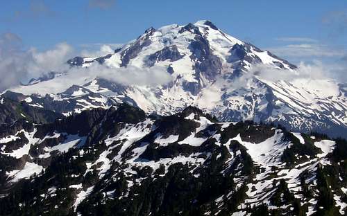
Glacier Peak from Meadow Mountain
Getting There
Please see the route description. Access either from the Mountain Loop Highway and FR23 (south of Darrington), or Highway 530 and FR26 (north of Darrington).The trail used to access this area is the Meadow Mountain Trail #657.
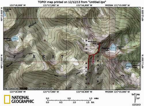
Meadow Mountain route map. I chose the east route from the basin. The "Fred Beckey Route" stays on the ridge crest to the west.