
|
|
Mountain/Rock |
|---|---|
|
|
48.23739°N / 121.90252°W |
|
|
Snohomish |
|
|
3604 ft / 1098 m |
|
|
Overview
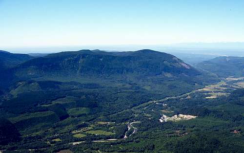
Wheeler Mountain from Mount Higgins
Wheeler Mountain is the tallest of the three ugly brothers (Blue, Olo, Wheeler) located on private timber land northeast of Granite Falls. Truthfully, Wheeler Mountain has very little going for it. It does have 1150' of prominence, so it may attract the strange breed of climber known as the "Peakbagger".
Unlike Blue and Olo, Wheeler has not had its summit clearcut recently, and consequently, has poor views from the top. There is a clearcut one mile southwest of the summit which does have fairly decent viewpoints. If it's just views you're after, Blue and Olo will give you equivalent or better rewards for far less effort.
It is strongly recommended that any would-be summiter of Wheeler Mountain be equipped with a mountain bike. It is a minimum of 32 miles round trip to the summit, and this assumes no side trips. There is a substantial amount of altitude gain and loss, so it would be helpful to be in good shape as well.
Update (6-2-15): Unfortunately, it appears that Weyerhaeuser is now managing this land, and a permit is now required.
The only reasonable way too access Wheeler Mountain is via a private timber road maintained by Longview Fibre. If you choose to visit this area on a weekday, you may be sharing this road with logging trucks - use caution! Below is a photo of the posted rules for using this area. The sign does say it is closed on weekdays, but I've been biking these roads for over 20 years with no problems. Just be respectful, stay out of active logging areas, and yield to all trucks.
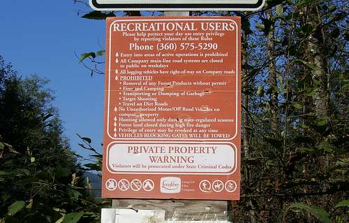
Sign on access road for Olo Mountain, Blue Mountain, and Wheeler Mountain
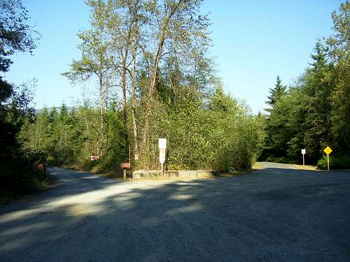 The road on the right leads into the private "Masonic Family Park". The road you want is the one on the left, which is maintained by Longview Fibre. Do not park in such a way as to block the gate. Also, do not be tempted to drive in when the gate is open - it may be locked closed at any time. Remember to always yield right-of-way to any trucks you encounter on the road.
Note: This area has many logging roads going in all directions. It is assumed that you have a USGS or Green Trails map of the area, and know how to use it. A GPS is also helpful when riding in this area.
Follow Road 100 north for 0.5 miles until the road forks (immediately after crossing Canyon Creek). Take the right fork (Road 200), and follow it for 4.3 miles to a large four-way intersection at Olo Pass (N48 09.560 W121 53.290 Elev. 1987'). Continue straight ahead at Olo Pass. There is a washout shortly after the pass which is easily negotiated by bicycles. (It is possible to turn left at Olo Pass to take the truck detour around the washout, but this will add considerable distance and elevation change to an already long day.) Follow the main road, dropping into the North Fork Canyon Creek valley, then climbing up the Jim Creek valley. Shortly after crossing Jim Creek on a bridge, you will arrive at an intersection (N48 12.320 W121 52.848 Elev. 2080' - About 6.0 miles from Olo Pass). Take the lesser used left fork. Within 0.5 miles of this intersection, you will break out into a large clearcut, which can provide some fairly good views.
Note - As on 2018, the 'straight ahead' option at Olo Pass is in fairly poor shape. The best option is now to turn left onto the mainline at Olo Pass. This will add 1.8 miles each way (and several hundred feet of elevation gain) to the distances mentioned.
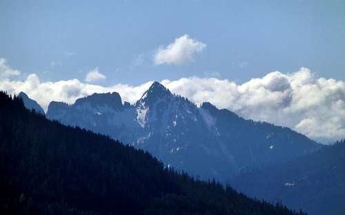
Fletcher Peak from Wheeler Mountain
Continue up the road, staying left at the major intersection at the top of the clearcut. You will eventually reach an intersection (N48 13.592 W121 53.458 Elev. 2780') where you have to decide between the views from the upper clearcut (left fork) or summit (right fork). If you take the left fork for the views, continue to an intersection at (N48 13.677 W121 54.922 Elev. 3220'). From here, continue right if you want mountain views, or left if you want Puget Sound views. The best west views can be found at (N48 13.449 W 121 55.042 Elev. 3120').
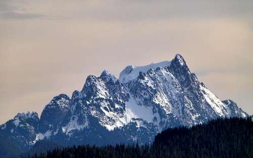 Whitehorse Mountain from Wheeler Mountain
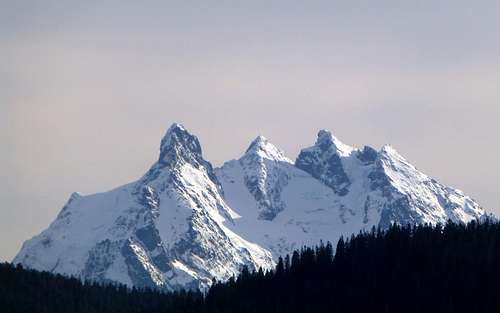 Three Fingers Mountain from Wheeler Mountain
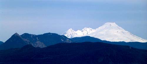 Big Deer, Little Deer, and Mount Baker from Wheeler Mountain
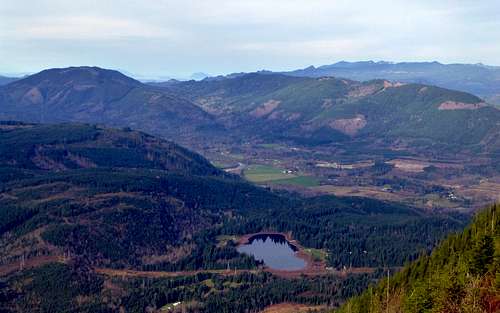 North Fork Stillaguamish River valley from Wheeler Mountain. The two mountains above the valley are Stimson Hill and Frailey Mountain. Below the valley is Ebey Hill and Riley Lake.
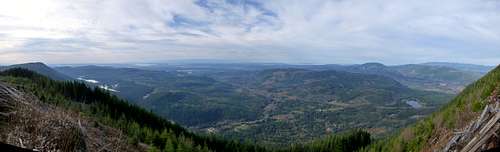 Wheeler Mountain west pano
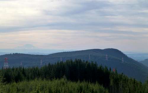 Blue Mountain from Wheeler Mountain. Eight of the Navy's 12 towers for VLF transmissions to submarines in the Pacific can be seen in this photo. Each tower is 200' tall, and the antennas between the towers are 1.1 to 1.6 miles long. This station transmits with 1.2 million watts, making it one of the most powerful transmitters in the world.
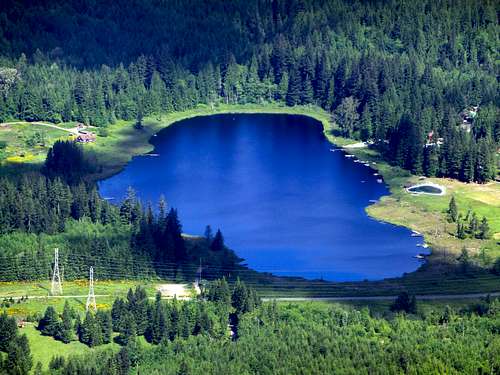
Riley Lake from Wheeler Mountain
For the peakbaggers going for Wheeler Mountains summit, a simple two mile road walk will put you on the top. There are a number of road intersections along the way, but I will assume anyone who has made it this far has a USGS map and GPS, and knows how to use them. There are occasional peakaboo views from the summit area, but nothing that compares to the views from the upper clearcut.
Note: The roads leading to the summit were mostly snow covered above 3000' for my hike to the summit (early June).
Getting There
Follow the Mountain Loop Highway east from Granite Falls for 4.4 miles, and find the large gravel "parking area" on the left side of the highway. Please do not block the road or gate.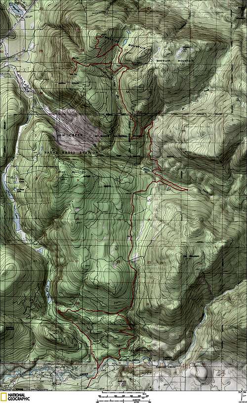 Wheeler Mountain route map. During active logging operations, consider using the 'west route' after crossing Canyon Creek, to reduce time spent on the mainline.