
|
|
Mountain/Rock |
|---|---|
|
|
42.94838°N / 5.79357°W |
|
|
Mountaineering, Sport Climbing, Big Wall |
|
|
Spring, Summer, Fall |
|
|
6467 ft / 1971 m |
|
|
Overview
Tres Marías is the name of people of the area and mountainers gave to a three near peaks, that are similar to each other. In fact most of the people I know call them just Tres Marías. Of course they have their own name: El Palero, María de Enmedio (Middle María) and María de los Corros.They have less than 2000 m but they are one of the most serious and respected in Kms arround. Also, they are well know by rock climbers who have in their vertical walls a perfect battlefield againts gravity.
The three peaks are situated on the beautiful Valle de Arbás, not far from the village of Casares de Arbás (1344m) and only 20-25 minutes on car from Villamanín, the main village in the area.
The name probably comes from some people of the village around though they look like three stone statues of Virgin Maria (there are a lot of examples of religious names to peaks, cols and mountains in general).
In my opinion, a more suitable name would have been "Colmillos de Lobo" (Wolf Jaws) or something like that, because in the distance they seem to be some kind an animal teeth biting the clouds. They have a mistyc atmosphere around them that make them one of the most especial mountains.
The low height, comparing with many other summits on Cordillera Cantábrica group, has an advantage for people looking for mountains with good access, relatively good weather conditions, good views and adrenalin.
Leaving apart the height differences between Tres Marías and Picos de Europa, they keep some similarity (great slopes and the kind of stone) but at low level of course.
The three peaks are situated on the beautiful Valle de Arbás, not far from the village of Casares de Arbás (1344m) and only 20-25 minutes on car from Villamanín, the main village in the area.
 View of Tres Marías from Villamanín
El Palero 1893 m
It´s the "little" one but the more exposed, difficult and interersting too. Its steep East ridge seens to be the only route, appart from climb routes. Out of the ridge are void and vertical walls. The last part of the ridge it´s the more complicated and requires all your concentration in order to prevent an accident. From its top there are a good view of the other Tres Marías and Arbás Valley. Unfortunatelly you have to be a really good rock climber to go towards the next peak: the María de Enmedio.
María de Enmedio 1930 m
The origin of the name of the peak it´s obvious: it´s on the middle, so María in the middle it´s its name. Probably the easiest one, with a good access from Valle de Arbas through the cols between the other two peak. North acces it´s extremelly difficult too.
Appart from the great landscape from the summit, it´s interesting to have a look to the neighbors on its West and East.
María de los Corros 1971 m
The highest one and maybe no so vertical as the other two. It has the particularitity of being accesible from the North face, but leaving on the North impresive precipices. As the highest one it let you the oportunity to get good pictures of the other two summits.
On the West it has another remarkable peak: Peña Ortegal, with 1993 m.
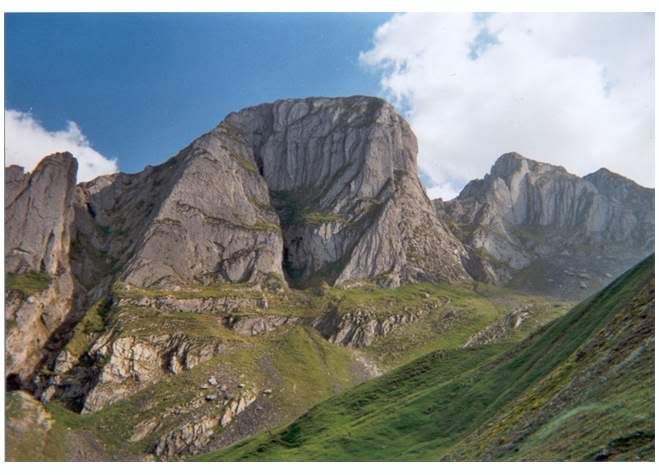
 Tres Marías peaks (Left to right: María de los Corros, María de Enmedio and El Palero)
Getting There
Probably the easy way it´s going on car to Casares de Arbás. Maybe you can find a coach from León to this village, or you can take a taxi from Villamanín if you don´t own a car. It´s possible to go to Villamanín on train (RENFE) or couch (ALSA).From León:
* Take N-630 to Villamín and turn left in the intesection towards Puerto de Aralla. After some KMs you´ll find the village of Casares de Arbás.
* Also, if you like curves and mountain roads, it´s possible taking CL-623 to the North, taking LE-473 towards Puerto de Aralla. Before reaching the top of Puerto de Aralla you´ll find a road on your left that goes to Casares de Arbás.
From Asturias:
Take A-66 to the South. Then in Campomanes village you´ll have to decide:
* AP-66 The highway is not free, but not very expensive, maybe the best option with bad weather. Left the AP-66 to CL-623. Go to the South through this road and turn left to LE-473 towards Puerto de Aralla. Before reaching the top of Puerto de Aralla you´ll find a road on your left that goes to Casares de Arbás.
* Letf A-66 on Campomanes towards Puerto de Pajares N-630. Puerto de Pajares it´s an incredible mountain pass for ciclists but not easy with bad weather and snow. If the weather it´s good you´ll enjoy the views.
Just turn right towards Puerto de Aralla on Villamanín village. In some KMs you´ll reach Casares de Arbás.
 Topomap
Red Tape
No permits required in all the area. There´s no dangerous animals in the area.Please take care of the environment and let it stay clean
North face of Tres Marías, cortesy of Pablo Iglesias Deligny
Camping
It´s not allowed to camp in the area. Maybe you can vivac in the mountain... probably in the col... but it´s not allowed to camp in all León territory. Only camp sites is the rule, but this is not allways true.You have lovely traditional houses (rural tourism) to spend the weekend in the area, you´ll find some of these in Valle de Arbás
There is a youth hostel in Villmanín. Very cheap.
You also have a private camp site in Villamanin (so you need to pay for camp there, but at least you have a shower and a toilet).
More of this pivate camp site (called Camping in Spanish) in La Vecilla, La Mata de la Bérbula, La Pola de Gordón, Puebla de Lillo, Barrios de Luna, Mirantes de Luna...
I´m not sure but I think there is a private camp site in Villamanín too...
Mountain Conditions
Remember in this Cordillera Cantabrica in general, the weather changes quickly, and storms are sometimes over your head in few minutes. Also, have in your mind the dangerous fog.The tempeture surely will be low from October-November to April-May, frozen on winter months.
Poles, gaiters, ice-axe and crampons will be a good options to climb these peaks if you find snow on your way.
I´d recomend allways a raincoat.
 María de Enmedio and El Palero from María de los Corros
Weather forecast:
[ Left ] Metosat satellite view provided by INM - www.inm.es -
* Note: the map shows the clouds evolution.
[ Right ] Reflectivity map provided by The Weather Channel - www.weather.com -
* Note: the map shows, from blue to red, the power of clouds.
 |  |
For more info use these links: Weather forecast today (English) | Weather forecast today (Spanish)
My Suggestions
* Taste the delicious food in the area. You have to bars in Fontún to try home-made and traditional food.* Go to Brañillín sky station if you like skying. As far as I know it´s not good and not big... but it´s maybe enough to have fun.
* Go to Puerto de Pajares top. Great views. I like cycling if you too, try to climb it with your bike, it´s really hard. Take care, a lot of traffic.
* It is said that cider from Asturias looses tastes in a different way (no so good) when it crosses the Puerto de Pajares pass. This is said because for many years this place was the main pass between Asturias and all the territories on the South.
Asturian cider, "sidra" it´s an outstanding product made with apples. It´s a low alcoholic drink, but take care my friend.
The main important thing about cider it´s how to serve it. You have to throw it taking the bottle over your head and the glass with the other hand lower than your waist. This is called "escanciar la sidra" It´s espetacular seing some people of the area doing this.
There is a great culture around sidra. Visit a tradional cider bar, a "chigre" (one of the best I know it´s "La Galana", in Plaza Mayor, Gijón). Also visit if you can a "llagar" the place where cider it´s produced.
* I strongly recomend visiting Cueva de Valporquero. I have spoken about it a lot. If you like it visit too Cueva de Llamazares (read about that in Bodón peak page).
* There is a lovely place called Bosque de Foedo, a little forest not very far from Ciñera de Gordón, some Km on the South of Villamanín. It´s a fairy tale place. Ask people from Ciñera how to get there. There´s a path. It´s not difficult and everybody in the village knows this place.
* Visit Torío and Curueño river valleys. You´ll find a detailed description in Correcillas and Bodón pages. (Sorry, I´ll send you there because I don´t want to duplicate too many information).
* If you want to get a lot of information about León province, what to do, where to go, what to visit, camp sites, hotels an accomodation you have this information free on tourist offices. I don´t know where they are in Asturias, but you´ll find a lot. In the León the biggest one it´s in front of the gothic cathedral. You´ll get free maps, hotel and camping guides, rural accomodation (tradional houses), monuments, cultaral activities... in many languages.
* By the way, visit León city. I´m not going to tell you all the things you can do there... but in my opinion you´ll like the visit. Also, Gijón and Oviedo are interesting places.
VERY IMPORTANT:
** Take a MOBILE PHONE with you. You can use it most of the mountain areas. If you can phone try going up or changing your position. I can remember my moibile ringing on the summit of Torre de Friero... I couldn´t believe it! Mobile is the best thing to make an emergency call.
Forget about radios.
Take note of this number: 987 718 004. It´s the number of G.R.E.I.M., Guardia Civil Mountain Rescue Team. They are really good proffessionals with lots of years of experience. If you have serious problems phone them: tell them who you are, how many people is in difficulties, try to tell them where you are, or at least a detailed description of the area.
Special Info
The meaning in English of some Spanish words.-------------------------------------------------------------------------
* Collado, collada: col, for instance "Collado de Gete"
* Pico: peak, for instance "Pico Fontún"
* Peña: peak (very tipical from León, Asturias, Santander), for instance "Peña Ten"
* Torre: peak (very tipical from León, Asturias, Santander), for instance "Torre del Friero"
* Cueto: peak, for instance "Cueto Millaró"
* Puerto: mountain pass, for instance "Puerto de Pajares"
* Cordillera: big group of mountains, for instance "Cordillera Cantábrica"
* Macizo: group of some mountains or peaks, for instance "Macizo Central, Urrieles of Picos de Europa"
* Cumbre: summit
* Cima: summit
* Canal: corridor, for intance "La Canal de Dobresengos", note it´s in femenine
* Canaleta: narrow corridor
* Hoces: canyon made by a river, for instance "Hoces de Vegacervera", "Hoces de Valdejeja"
* Valle: valley, for intance "Valle de Valdeón"
* Río: river, for instance "Río Torío"
* Horcado: narrow col between two peak, normally difficult to cross, for intance "Horcado de Pambuches"
Books I recomend.
-------------------------------------------------------------------------
Montañas de León (in Spanish only)
Ramón Lozano, Santiago Morán
Everest Editorial
ISBN 84-241-0404-8
Description in detail of more than one hundred routes across the mountain of the León province, including the Picos de Europa Area and many others.
Book details (English) | Book details (Spanish)
50 montañas de la Cordillera Cantábrica (in Spanish only)
David Atela
Desnivel Ediciones
ISBN 84-96192-90-3
Really useful book about the most remarkable mountains in Cordillera Cantábrica massif. It doesn´t containt anything about Picos de Europa area so it lets it go along another interesnting and no so famous mountains.
Book details (Spanish)
Another remarkable peaks in the area
* Los Currillines, Currillos, Peña de los Bueyes - 1942 m* Bodón - 1960 m
* Machamedio - 1916 m
* Barragana - 1901 m
* Peña Ortegal - 1993 m
* Cirbanal - 2081 m
* Braña Caballo, Cueto Millaró -2181 m
* Cerro Pedroso - 1909 m
* Fontún - 1948 m
 Cerro Pedroso view from Barragana Cerro Pedroso view from Barragana |
 Cirbanal peak, in the distance Peña Ubiña from Barragana Cirbanal peak, in the distance Peña Ubiña from Barragana |
 Fontún (center left) and Correcillas peak (center right) from Barragana Fontún (center left) and Correcillas peak (center right) from Barragana |
 Machamedio peak from Valle del Marqués Machamedio peak from Valle del Marqués |
 Left to right: Barragana, Peña Ortegal and the three peaks of Tres Marías Left to right: Barragana, Peña Ortegal and the three peaks of Tres Marías |
 Braña Caballo view from Valle de Arbás Braña Caballo view from Valle de Arbás |
The Spanish corner :-)
Info in Spanish for Spanish Speakers & Spanish Studients:Para todos aquellos que no tengan un inglés súper, y yo me incluyo, he decidido añadir esta sección. También para todos aquellos que estudian o están aprendiendo español.
Las Tres Marías son tres estilizados y retadores picos del Norte de León, a tiro de piedra del Principado y de la estación de esquí de San Isidro.
Como ya expliqué, El Palero es el número uno de dureza y dificultad, y por si solo podría justificar una página en SummitPost. Irónicamente el más bajo, pone a prueba la resistencia mental de aquellos que asoman a los abismos que flanquean casi todo su perímetro. Sólo nos ofrece una arista Este, que como una rampa con algunas curvas, nos conduce a su cumbre.
Las otras dos Marías, realmente merecen mucho la pena. La más Occidental de ellas, la de más altura también, cuenta con la inestimable ventaja de permitir el acceso a otras cumbres como Peña Ortegal, situada continuando el cordal más al Oeste.
Sin lugar a dudas, de haber contado con unos centenares de metros más de altura tendrían el renombre y la fama de Peña Ubiña, el Espigüete, los Mampodres, Peña Prieta o los propios Picos de Europa.
Para una información más detallada os remito al texto en inglés. Si tuviéseis algún problema estoy a vuestra disposición para facilitaros toda la información que esté a mi alcance.
External Links
- Cristino Torio´s web site>Cristino Torio´s web site
Web about León Mountain by one of the most well known climber in the León province (Available only in Spanish)
- Web Site about Picos de Europa and the North mountains
Information, photographies a lots of things about Picos de Europa, the tallest montains along Cordillera Cantabrica and the North of Spain. It counts with a valuable informations by the hand of the people on the forum, most of them experts in these mountains. I´m sure they can answer your question even in English, French or German (Available only in Spanish)
- Castilla y León Tourism Official Web Site
You can find here many information about this region, as camp sites, accomodations, monuments, culture, nature, it could be a valuable tool to plan your holidays and trip along the mountains of this region. (Avalaible in many languages)
- Web site about the Riaño mountain
Good information about the area arround this village and the mountains arround (only in Spanish)
- Complete weather information
A lot of information about meteo. Satellite views and different weather forecast models (only in Spanish)