

|
|
Mountain/Rock |
|---|---|
|
|
44.15869°N / 113.14703°W |
|
|
Butte |
|
|
Hiking, Mountaineering, Scrambling |
|
|
Spring, Summer, Fall, Winter |
|
|
10717 ft / 3267 m |
|
|
Overview
Peak 10717, as it is officially known, lies 3 miles northwest of Diamond Peak in the Lemhi mountain range of eastern Idaho. It is the 167th tallest peak in the State. In tracing the history associated with this peak, Rick Baugher, an accomplished local climber and mountain historian, stated that on his summit visitation in 9/22/90, he did not see any sign of prior summit visitation. Wanting to give the peak a personal name, he chose Amy’s Peak (for both his younger daughter and the Amy family, who live in the Little Lost River Valley in the Clyde area). The neighboring peak to the northeast, Peak 10984, which Baugher also summited, he named in honor of his oldest daughter, Lexi’s Peak. Baugher speculates that Peak 10717 and 10984 were after that point referred to as Big and Little Sister, which is how the peaks are referenced in Idaho, A Climbing Guide, by Tom Lopez, and how they are now commonly known. Little Sister is typically accessed by its west ridge, snow free as early as March.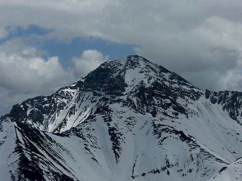
Diamond Peak from Little Sister
Climbing Little Sister will quickly take you from the sagebrush-steppe valley through open white bark pine/juniper forests, over rock gardens and/or over snow, along a slightly exposed ridge line and open into a broad final summit face push. All the while you will be accompanied by outstanding scenic views of the Lost Rivers to your west and Bell Mountain and its neighbors to your north. As you exit the ridge section to your final approach, the Lemhis will grow around you, and Diamond Peak to your east will welcome you as you take your final steps to Little Sister’s summit area. This mountain rarely gets climbed so you are almost guaranteed to have the summit all to yourself.
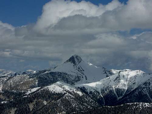
Bell Mountain from Little Sister
Getting There
There are several ways to reach the access for Little Sister. If you are traveling from any direction, other than from the north, your immediate objective will be to reach Howe, Idaho. Once you reach Howe, take the directions "From Howe."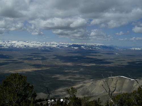
Little Lost River Valley
From Boise
Take I-84 east to Mountain Home where you will take exit 95 to highway 20. Follow highway 20 all the way through Fairfield, Carey, and Craters of the Moon to Arco. At the major T intersection in Arco turn right to continue following highway 20. If you turn left you will end up in the Big Lost River Valley which is a cool place but is not where you want to be. After turning right in Arco you will soon leave town, pass through Butte City, and work around the Southern edge of the Lost River Range. A few miles after Butte City there will be a major turnoff with a sign directing you to Howe/Highway 33. Turn left here. If you reach the sign telling you you've entered the INL (Idaho National Laboratory), you've gone a little too far. After some time you'll come to the very small town of Howe. Here the road splits again but just keep going straight. The right option will take you to Dubois and Rexburg. (Go to the "From Howe" section.)
From Pocatello
Take Interstate 15 north to the Blackfoot/Highway 26 exit. Turn left. Stay on Highway 26 until it intersects with Highway 20 coming from Idaho Falls. Turn left on Highway 20 past the INL and past the rest area on the left (this is the only public restroom before you reach the campsite). You will begin to look for signage to Howe (Highway 33, the Little Lost River Highway) after this point. Turn right at the 3-way intersection and continue on to Howe. (Go to the "From Howe" section.)
From Idaho Falls
Take Highway 20 west past the INL and past the rest area on the left (this is the only public restroom before you reach the campsite). You will begin to look for signage to Howe (Highway 22/33, the Little Lost River Highway) after this point. Turn right at the 3-way intersection and continue on to Howe. (Go to the "From Howe" section.)
From the North
Depending on your point-of-origin, obtain the Little Lost River and travel southeast toward Clyde/Pass Creek Road turnoff. When you are within 4 miles of Clyde, begin looking to your left for a turnoff that immediately crosses a small stream and continue with the directions starting "Just past Clyde..." in the next section.
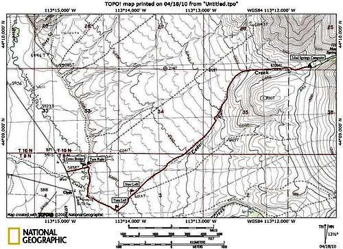
Map from Clyde
From Howe
At this point you will enter the beautiful Little Lost River Valley. In about 30 miles you'll come to Clyde which is nothing more than a small ranch. To the left you'll see a sign directing you to Wet Creek via Pass Creek Road. This is not where you want to turn but it is good to know since Clyde is not signed at all.
Just past Clyde you'll cross a small stream and there will be a turnoff to the right just past it. Turn here. You will soon cross another bridge over the Little Lost River and immediately after this you'll need to take the first right. This road runs along the base of a ridge for a little ways before coming out onto a flat sagebrush plain. The road will split or intersect two more times and both times you'll need to stay to the left. Eventually you'll begin to follow a dry creek bed which will lead you to a flat and grassy camping area at Mud Springs. Park here. The Peak is to the southeast and the summit is not quite visible.
Approximate time from Bosie to the campsite is 4.5 hours
Approximate time from Pocatello and Idaho Falls to the campsite is 2.5 hours.
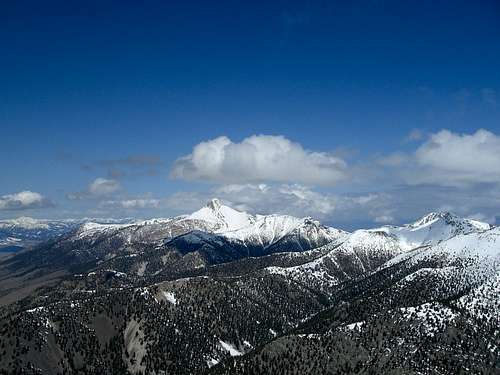
View North from Little Sister.
Red Tape
As with most Idaho mountains there is not much red tape involved. The only thing you'll need to be sure to have is a high clearance 4WD vehicle. The road to Mud Springs is pretty rough.Weather

Camping
The best camping is at Mud Springs. There are no facilities; however, there is a large grassy area perfect for tents and there is water available from nearby springs.
External Links
Idaho Outdoors ForumSplattski's Trip report
Idaho Summits TR

Idaho Summits Group on Little Sister