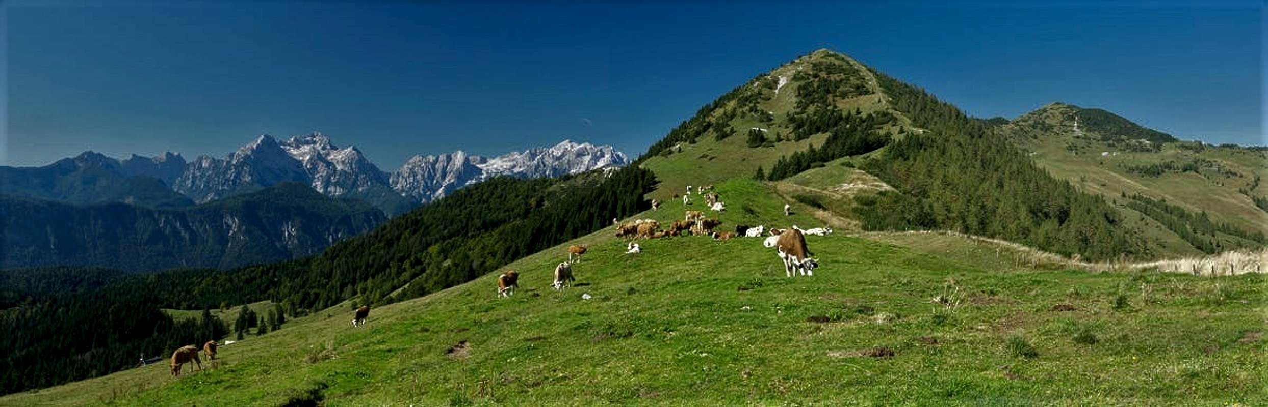
Looking eastwards along the crest of Košuta / Koschuta while hiking to Hainzturm
It’s been 12 years since we last went to Slovenia, a very long time, given the fact that we enjoyed our 2007 stay very much. Granted, weather wasn’t to encouraging back then, but during the five or six beautiful days we had, we thoroughly enjoyed the country. We stayed at Kranjska Gora and spent our time in the Julian Alps and western Karavanke / Karawanken either in Slovenia or just across the border in Eastern Italy.
The most memorable event was a gathering of SP members, at first in a Pizzeria in Kranjska Gora, the next day climbing Dovški Križ, complete with pancake disaster and northern scree kangaroo, which ended after an accident in the hospital of Jesenice. You can read about the meetup here.
Jasmina, Judith, Vid and I stayed in contact and in 2012, while we stayed just across the border in Bad Eisenkappel Austria,, we once again met, however only for a dinner. Vid and I stayed in contact through SP and when we decided that September 2019 we would return to Slovenia, he was the first (and only) one I asked about a good base for our stay. In the end we decided on a flat near Bled, mostly because Julian Alps, Karavanke / Karawanken and Kanmik / Stein Alps looked easily reachable from the spot.
Vid and I discussed possible hikes together but postponed a decision until we had actually arrived at our apartment.
Sept 14th – Travel Day
The Julian Alps behind Rosenkogel and Frauenkogel
It is Saturday, 5 a.m. and we are getting ready for the 800km trip to Bled. I’m shuffling baggage out to the car, wondering as usual how all this stuff will fit into the trunk. But in the end, also as always, it does and at 5:40 we set out onto the road. The first three hours are ok but from Nuremberg onwards we have to make detours and Munich is the expected bottleneck. Once past Rosenheim traffic gets back to manageable, we cut through Austria from Salzburg through the Tauern- and Katschberg Tunnels and find ourselves in Carinthia with the Karavanke / karawanken just ahead. We dive beneath them through another tunnel and after heading out at Jesenice reach our destination after 10 hours.
We have a nice apartment in Koritno, south-east of Bled and the only thing mentionable of that day is the parking ticket we get while having dinner at a pizzeria in Bled. 40€ - this vacation is up to a quick start.
After returning home, Vid calls and we agree to meet up the next day. Begunjščica might be a destination or Techantinger Mittagskogel / Trupejevo Poldne, maybe even Mojstrovka. At 8:30 Jasmina and Vid will pick us up and then we'll see what tomorrow will bring.
Sept 15th – Mala Zelnarica and Kopica
Jasmina, Vid and Judith on Planina pri jezeru
At 8:30 Vid pulls into the parking lot of our apartment and we go outside to meet Jasmina and him. We haven’t seen each other in 7 years and it’s a real nice feeling to see both again. After the heartfelt welcome from all sides we quickly turn to discussing where we’ll spend the day. And for some reason or other (probably weather related) we decide to forgo yesterday’s plans and go to Bohinj Valley instead. There’s a trailhead it seems, which gives us several options and as there’s fog all around we might be in need of as many options as we can get.
During the drive Vid plays tour guide and explains quite a lot. From train rides through Bohinj Valley, to the strange character of Bohinj’s residents, from the downsides of tourism to the four brave fellows who climbed Triglav first and whose monument we saw in Ribčev Laz – we get to know everything we need to – and a bit more as well.
There’s a toll road to the trailhead and up there dozens of cars park beside the narrow dirt road. It takes quite a while until we have turned the car and managed to find a parking space. We’re already a bit late and quite a lot of people seem to be on their way already. But anyway – we are already high inside the clouds but since the first hour of hiking takes us through the forest we don’t worry too much.
We finally arrive at Planina pri Jezeru where there is a mountain hut and take our first break to decide which of the possible routes to follow. In the end we follow Vids suggestion which includes a ridge traverse with wonderful views. In this fog it is unclear how the views will come in place but there’s still hope for the clouds to lift or melt.
And wonder amongst wonders! At the end of our next stage at Planina Dedino Polje we see a stretch of blue sky and consequently decide to follow the route which heads there. Beneath this blue patch of sky a serious looking limestone tower makes an appearance. “That’s Kopica and though it looks serious you can quite easily reach its summit!” Vid claims. And it's part of the ridge traverse we plan to go on. Wonderful!
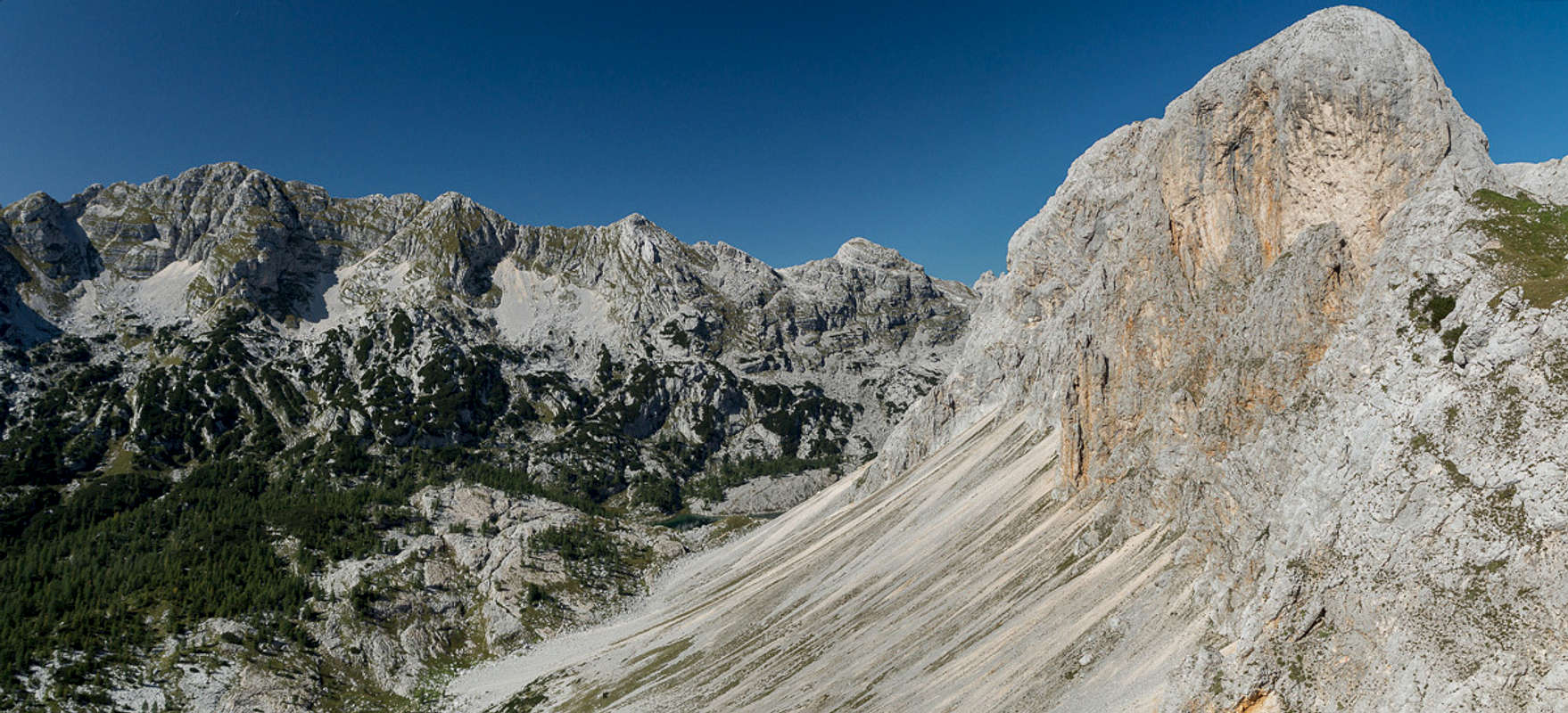
Soon we head above the clouds (maybe they simply vanish) and at the same time reach the timber line. There’s Mala and Velika Ticarica in front and behind us a sea of clouds fills Bohinj Valley. We turn a corner and suddenly enter the world of karst. A limestone valley stretches northwards with our intended ridgeline to the left and another similar one to the right. Vid tells us that beyond our ridge there is an abrupt drop towards the valley of the Triglav Lakes but from here we seem to be looking at round-topped hills. In the valley we have dolines (cave-ins) and lots of rubble. But finally we end up in Vrata Saddle, a good lookout towards the backside of the Martuljek Group of the Julian Alps.
Though we haven’t reached a summit yet we decide to have lunch in the saddle. People join us coming up from the Triglav Lake Valley and we all enjoy the views southwards across the still fog filled Bohinj Valley. Or northwards toward Škrlatica, the second highest mountain of the Julian Alps.
After lunch we pack up again and head onto the hiking trail to Mala Zelnarica. It touches the saddle between Mala and Velika Zelnarica and we have a first glimpse of the Triglav Lakes Valley. And indeed it’s a huge and sheer drop down there. A few curves and switchbacks take us to the summit where in deed we have a wonderful view. It looks like we are right in the centre of the Julian Alps and the who is who of the mountains is on display. Trigav, Jalovec, Kanin, Krn they are all there and what a wonderful place it is to stand here on the first day of your vacation seeing all those possible destinations.
To the south we see the trail which we’ll follow and it somehow runs in parallel to the sheer drop I have mentioned before. At first the remaining mountains on the ridge look far from impressive but the lower we get the more their summit blocks seem to pile up in front of us. And looking back along the ridge we see a far more impressive view of Mala Zelnarica as well.
From one of the saddles we climb a small bump on the ridge. We now are on the top of Kopica, that tower we saw beneath the first patch of blue sky. I’m tempted to keep moving southward but Vid reminds me of the face we saw in the morning. I’m convinced and we return back to the last saddle. Passing Kopica we are soon on its southern side and it becomes obvious why I shouldn’t have been able to keep going. Kopica has a huge south and an even bigger west face, the latter towering above the highest of the Triglav Lakes.
The Kopica South Face above the Triglav Lakes Valley
Now we head for Ticarica, which we pass in its west and the dive back into the forest. It’s a long slog towards Planina pri Jezeru where we arrive there quite late. Jasmina and Vid suggest having dinner there, which turns out to be some vegetable soup and we fill up to regain the power for the last hour back to our car. While we rarely met anybody the whole day, here at the hut – where several trails meet – groups of people come and go. Almost everyone has something to eat or drink at the hut, also preparing for the last part of the day. The sun hides behind the mountains now and it gets cold, so we quickly finish our dinner. We leave and somehow everybody seems to be hiking in his or her own bubble. We don’t talk anymore, being thoroughly tired. We reach the car and vid drives us along some backroads to our apartment in Koritno. Thanks for that wonderful day, Jasmina and Vid!
Hahnkogel / Klek seen during the ascent to Rosenkogel / Hruški Vrh
Having been inside the Julian Alps yesterday we decide to have a look at them from the outside. Another ridge traverse and one which can be prolonged at will as there are trails all the way. We’ll go to the western part of the Karavanke / Karawanken Range. Here the mountains are grass covered hills (more on that later) which reach heights between 1700m and 1900m. However, you start at 900m and if you plan to hike more than one summit you quickly gain a lot of elevation.
The trailhead is at Planina pod Golico, a village to the north of Jesenice, the largest town in this part of Slovenia. It is quite close to our apartment so we can start real early. We head to Jesseniška Planina (a farm) and on to Rosenbachsattel, the saddle which separates Rosenkogel / Hruški Vrh from Hahnkogel / Klek. As you can see from the names, the mountains are located on the border between Austria and Slovenia and thus all have two names. The going is very steep and once we are up at the saddle we have to take a break to get our breath back.
360° summit panorama from Rosenkogel / Hruški Vrh
Our first destination is Rosenkogel / Hruški Vrh to the west of Rosenbachsattel. Though just a grass covered hill, the slope is surprisingly steep and dwarf pines lead to an uncomfortable bushwhack. On the way up I see a black viper (Vipera berus) but am too slow to catch a photo of it. It’s windy up here and big ravens use the updrifts along the slope for some aerial acrobatics. The view is great with the Julian Alps just across the Sava Valley to the south and the long Karavanke / Karawanken ridge to the east and west. Far away in the north the glaciers of Hohe Tauern twinkle in the intensive sunlight.
We soon head back to the saddle and tackle our next destination, the summit of Hahnkogel / Klek. It has a vertical west face (a steep northern one, too) and we follow the ridgeline along the drop zone. Again dwarf pines bar the way but we reach the summit in time for lunch. Here the views are a bit less impressive, mainly thanks to the second Hahnkogel Summit, which bars part of it. But still it is a nice place to get to know the area.
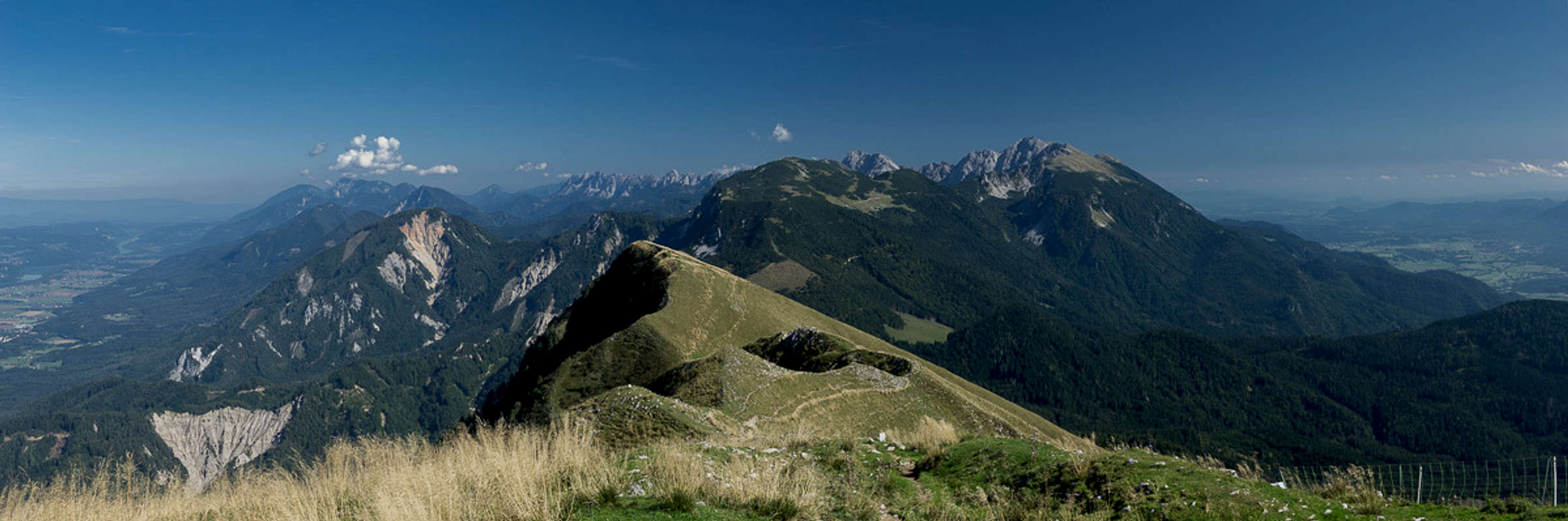
Central and eastern Karavanke / Karawanken seen from Golica / Kahlkogel
Descending along the north-eastern ridge turns out to be a bit tricky. The slope through dwarf pines (you guessed it) is slippery and for some reason or other we even lose it, freestyling towards the main path, which passes Hahnkogel / Klek altogether. Another saddle and then we find ourselves on the western slopes of Kahlkogel / Golica, the tallest of our three mountains. The hike towards its summit is surprisingly long and we reach it quite late in the day. A few shots and we descend towards Golica Hut were we take our last break. A long descent through dense forests takes us back into the valley where a 3km road hike takes us to Planina pod Golico. Again we are very late, again we are very tired but it was worth it!
Sept 17th – Jôf di Miezegnot
Today the weather forecast is mixed. Dense clouds are forecasted above the central Julian Alps with murky weather in the east. The farther west you go the more sun you can expect. Thus we plan to go to Kranjska Gora, to cross Vršič Pass and see what we can climb there. However in Kranjska Gora there is a sign, telling us that the pass road is closed until Oct 4th – the day before we’ll leave. Great! Thus most of our plans fall victim to this road closure, today’s plan among them.
We turn around and head towards Italy. While we are driving we discuss how we can save the day. I suggest Monte San Lussari and Cima del Cacciatore, which are close but Judith disagrees as most of the hike goes through forests and she wants to catch the sun as much as possible. Especially on a mixed day like this. Thus I suggest Jôf di Miezegnot, a mountain in the north-west of the Julian Alps with famed views towards Jôf di Montasio and Jôf Fuart, the big ones in the area.
Jôf di Montasio
We drive up Val Saisera to the parking lot at its very end. Here you already are very close to the big amphitheatre of Jôf di Montasio and Jôf Fuart and currently (at least) the weather is still very fine. We marvel at the big walls before we start the hike towards our first destination, Rifugio Fratelli Grego. While weather is still nice in the distance and around the summits the first clouds are forming. Maybe we’ll have to be very quick to reach the summit before the whiteout.
After the rifugio we dive back into the forest and once we head out of it on the upper Miezegnot Slopes, the vicinity is already covered in dense fog. Monte Piper to the west can be barely seen but Jôf di Miezegnot itself is still free of clouds. The slopes are very brittle and going up is already quite slippery. The descent is bound to be pure fun! In WW I the Austrians had positions on the ridge from Miezegnot to Piper to Due Pizzi in the west and we follow the old support trails. There are some cables to secure the path but – as usual – the worst parts can’t be secured so you have to be extra careful.
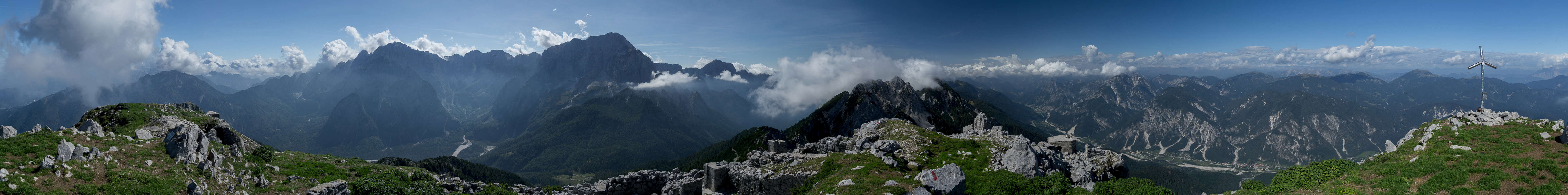
360° summit panorama from Jôf di Miezegnot
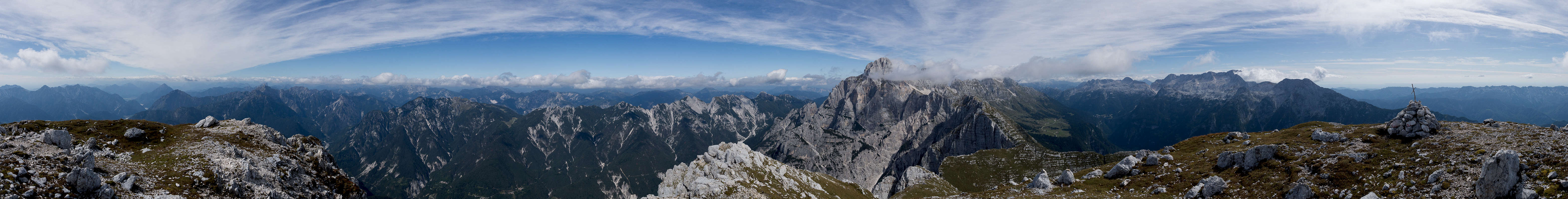
But finally we reach the summit (still outside any fog) and have a decent 360° view. There are concrete bunkers up here – Kanaltal / Val Canale to the north saw some of the first fighting of WW I and Miezegnot offers a good overview over the theatre of action. It also is probably the best place for the Fuart / Montasio Amphitheatre, with these massive mountains on full (and close) display right to the south.
Descending we stop at one of the cave entrances – a former military position – and I take a shot of cloud covered Monte Cimone in the south-west. Then we descend along the east ridge in the hope of better terrain than the route we came. In vain! You really have to be extra careful here, there is scree on steep rocks and more than once we start to slide towards uncomfortably steep drops. But finally we reach a traverse which leads us back to our ascent route. Back into the forest we dive. At each opening we wonder about the weather which turns out to be better than forecasted but we don’t complain. Again we are late – plus we have a long way to drive – we seem to have set a pattern for this vacation already.
Sept 18th – Tscheppaschlucht and Bodental
Tschaukofall
Today there is nothing good to be expected from the weather. It’ll be best across the border in Austria but certainly not good enough for the climb of a mountain. Thus it’s a canyon day today and we drive across Loibl Pass to visit Tscheppaschlucht. We have been here before in 2012 in similar conditions, but what can you do? You gotta keep moving…
Parking is 2€, there’s a fee for the gorge as well, 7,50€ per person. So we’re 17€ down at the start of the day so it better be a good one! Well, the gorge is ok, we’ve seen more impessive ones but after all there are quite a number of nice waterfalls. And on the upside – a bus transfer is included in the gorge ticket. So there is some return value for the price.
Nice mills in Bodental
From the central part of the gorge we head out into Bodental, a valley which is renowned for Märchenwiese at its end (fairy tale meadow), the “most beautiful” valley end in Carinthia. It might be beautiful but both times we were here we didn’t see much – clouds have descended almost down to the valley floor. We’re back in Bodental in time to catch the bus and thus ends an uncharacteristically short day.
Sept 19th – Steinbock Sightseeing on Monte Cimone
Heavy weather above Jôf di Montasio
Pretty much the same reasoning which took us to Jôf di Miezegnot two days ago takes us back into the area, this time to Sella Nivea and the Altipiano di Montasio to climb Monte Cimone. There is an additional reason, however: my boss – after writing the protocol to our last meeting the day before we left, wrote: “We wish Gangolf a wonderful vacation. And we want to see Steinbock (ibex) photos!” I have read his mail last night and as we saw ibexes on Monte Cimone 12 years ago, there is good reason to hope I can fulfill his wish. I’ll be on the lookout!
The first impression of Jôf di Montasio as we get out of the car is a bit alarming. There are fat clouds arranged around the summits of the group. You can only hope the forecast is correct and things will get better in the afternoon. In the south – in the Kanin Group – they already are – a sign for things to come?
The hike starts with a slope traverse, still beneath the timber line. There’s not much to report except occasional views of Monte Sart in the Kanin Group. Finally we start our ascent which will lead us to the gates of hell, Forca di Vandul, a scary notch on the ridge between Monte Zabus and Pizzo de la Viene. And here we see our first (lonely) ibex. It is sunbathing but as we get close, stands up and slowly walks away. Next we reach Forca di Vandul – and as last time we are absolutely impressed by its vertical walls to the east and west and its almost vertical drop to the north. Surely the gates of hell can’t look much differently.
Now we have to climb a steep ferrata. Without gear it is a bit scary even though steps have been cut into the rock here and there. “Look there!” Judith cries out, as an ibex kid watches us from above, probably wondering why we humans make things so complicated. Climbing vertical walls can be so easy, when you have the right equipment at your hooves. Mother and sister are also watching us and as we finally reach the top of the climb they show us how it’s done in the real world.
360° summit panorama Pizzo de la Viene
This world is made up from lots of parallel ledges, separated by 5-10m rock steps. There’s a lot of grass on the ledges and it must be the perfect setting for raising ibex kids. We negotiate the steps by following some switchbacks and finally find ourselves on the south ridge of Pizzo de la Viene. The views open up and the closer we get the more we can see of Jôf di Montasio, which looms up high behind Monte Zabus in the foreground. On the other side Monte Cimone finally can be seen, also with the ledge-step structure you see anywhere in the Montasio / Fuart Group.
As we near Forca de la Viene we realise that the valley beneath is home to a herd of some 50 ibexes. As we walk by we see a second group, certainly as big, if not bigger. And on the upper ledges of Monte Cimone there are smaller groups but lots of them! What is going on here? And I’m not talking about young and small ibexes – these here are all the feisty old variety. I’m sure I’ll get some good shots for my boss…
But first – the summit. Climbing Monte Cimone is not as easy as it looks. The rock steps are tall and quite slippery in many places. It takes far longer than we had anticipated. Then, topping out on one of the ledges we startle the biggest Steinbock we have ever seen. It looks back at us just as amazed as we feel and after we move closer he “flees” at a slow stolling pace. These guys surely have no natural enemies!
360° summit panorama Monte Cimone
On the summit the panorama is wonderful. But after all these animals it still feels a bit underwhelming. Even though most clouds have disappeared and Montasio is now almost fully visible while Jôf Fuart makes a short appearance. We have lunch, still discussing the ibexes, then start heading down the way we came. The big guy is still where we left him, there’s a lady with a kid nearby and closer to Forca de la Viene we meet a trio with one clearly really old guy.
But that’s just the start. From Forca de la Viene we have to follow the Viene Gully and that’s where the big herds are. We close in slowly, not kowing how the animals will react on us. They are far heavier than we are and if they take it into their heads to let us feel their horns we’re done for. But instead they pretend to ignore us, like any male ibexes we have encountered so far. Later they get restless, getting up, watching us closely and turning to be ready to flee. Then a small groups gallops across our path to join another one obviously grouping around the oldest and biggest Steinbock of them all.
As we pass the biggest group and descend further down the gully we realize that now the animals are much younger. They still are living in huge groups but surely more nervous than the big guys. Still further down we meet with smaller groups (up to a dozen animals) of lady ibexes witheir kids. These animals are very curious and they put out one of the oldest ladies to watch us while the kids and their mothers hurry away. All in all we reckon we saw 200 animals on Monte Cimone and in Viene Gully!
After that the day is done. Even though we still have two hours to go back to Altipiano di Montasio somehow nothing impresses us anymore. Much of the route is steep and slippery, the day turns late, the sun sets behind Monte Cimone and we are getting real cold. It’s really late when we’re back at our car and 90 minutes later we finally return to Koritno and our apartment.
But what A day!
Sept 20th – Slatnik, Kobla, Šavnic, Možic
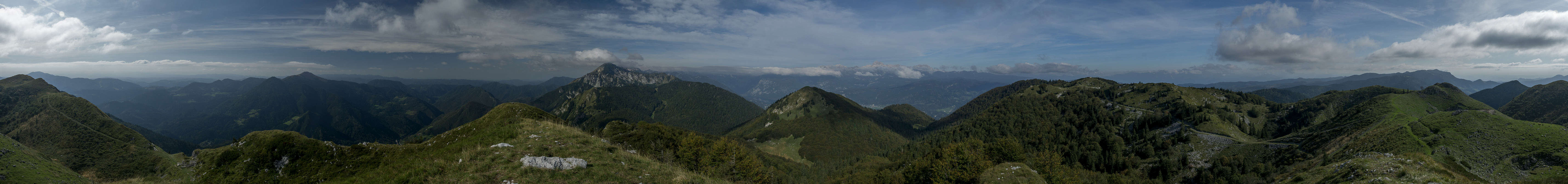
360° summit panorama Slatnik
Today we’re back in the Bohinj Valley. Or rather on a road pass which leads out of it in the south. Judith has found a bunch of summits which can be reached from the pass and since weather is forecasted to be good we hope for good panoramas. For these we have to negotiate a ski area first. But it’s a small ski run only so we will be past it in a breeze.
Actually not quite – first I forget half of my equipment in the car and have to return. Then we realize that the trails on our map don’t have counterparts in real life. We follow what our mobiles indicate as a track and at some point the real one comes alongside. Following it we quickly get to the summit of Slatnik and the expected views are there. It’s a bit early still but behind the summits we want to climb today the long chain of the Julian Alps looms.
I take a few photos and then we descend towards the west, next destination Kobla. We have to dive into dense beech forest, however, so that for the next 2h we see little more than trees and mushrooms. Only as we start to climb towards the Kobla Summit the path heads out of the canopy and finally we’re able to see something. However, clouds have started to form meanwhile and the vista is far from perfect. Also, it has become late and a turnaround is required. Back into the woods we go…
Dravh, Lajnar and Slatnik
Before returning to the Slatnik ascent, Judith suggests an alternative route back to our ski area, bagging two more summits, Šavnic and Možic. The former turns out to be a round-topped hill, where we have a nice view of Karavanke / Karawanken (Julian Alps behind a cloud cover). The latter is similar, but has a military position on its top, dating back to the time between the World Wars. There are more of these positions in the vicinity and you can actually explore them. We don’t but instead head back to Slatnik and down to the road pass to our car.
Sept. 21st – Košuta / Koschuta, western part
Last night I had a call with Vid and we agreed to hike together today. Either Begunjščica or something on the 10km long ridge of Košuta / Koschuta. Now we’re driving to Tržič where we meet Jasmina and him at the local gas station. We quickly agree on Košuta / Koschuta. We want to drive to the centre of the ridge from the southern side and then decide whether we prefer to hike west or east. Probably west because it’s the easier and shorter route.
But there is a sign saying that the road along Tržiška Bistrica is closed. However, there’s a marked detour and we decide to follow it. At first it runs along paved road but then the asphalt stops and we wind our way across mountains, hills and valleys endlessly. Once we’re finally in Tržiška Bistrica Valley, a big earth mover bars the way and we have to wait. It’s taking forever… Finally we’re back on track and head up to our intended trailhead near Planina Pungart. After all this loss of time it’s clear that we will hike the western part of the Košuta / Koschuta Ridge. No need for any decision anymore.
Our team taking a rest in Škrbina Saddle
At first we kind of freestyle through the woods from our parking space. But after a short while we join a level trail which takes us to the real ascent route to Škrbina Saddle. It’s steep, not too much, but runs over an open meadow so that you can see where you’re going. Škrbina is a sharp notch in the middle of the Košuta / Koschuta Crest and as we reach it we realize that is drops dramatically on its northern side. Vid says that formerly the saddle was used to ferry animals across Košuta / Koschuta but we all agree that this barely looks possible.
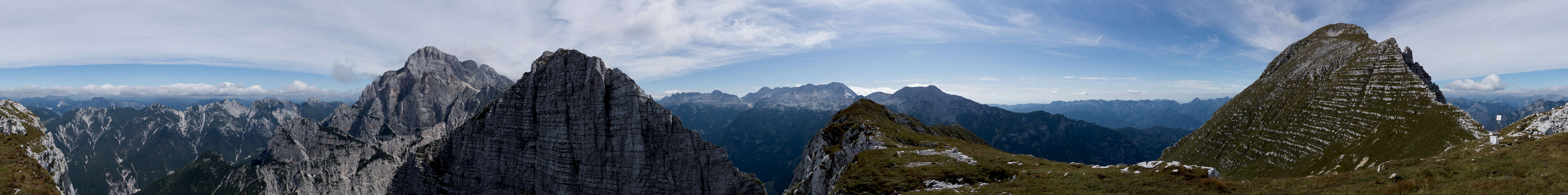
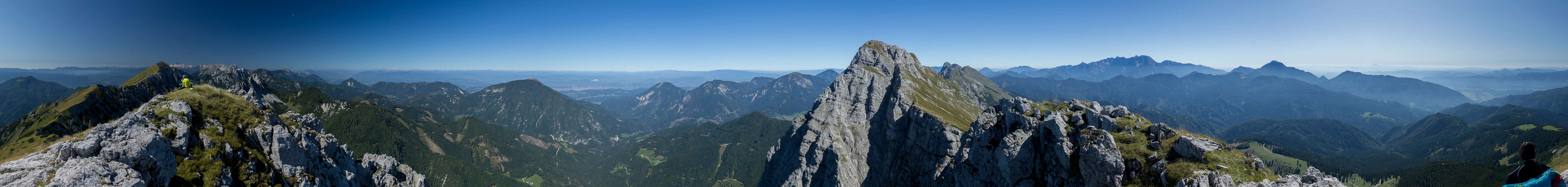
It’s freezing cold up here and everybody picks out their clothes. It takes a while to put them on since the wind is also nasty. But once we’re done we turn west and start tackling the ridge. It’s a striking contrast between the rocky northern side and the steep meadows in the south. The moon is setting above our first main summit, Kladivo / Hajnzturm. It’s a perfect setting for photographers – always changing vista looking back and forth, with some nice faraway views as well. The north faces are dramatic.
360° summit panorama Hainzturm
Somehow I drop back with my camera, it’s just wonderful what I’m seeing and it is such perfect weather. The traverse to Kladivo / Hajnzturm takes much longer than I thought – there are just too many minor summits on the ridge. The path mainly stays on the ridge with a few detours to the slopes in the south and finally we can really see our summit in front of us. There are already a lot of people on it and we have to look for a bit of space for ourselves. Finally we can see the Julian Alps and the western part of the Karavanke / Karawanken – the weather couldn’t be better today. Vid interviews some of the other people on the summit if they all went through the detour and we have to realize that we could have gone the regular road. There was construction but some of the people of the summit drove their cars right through it. Hmpff!
Strangely enough, despite our driving detour it’s still too early for lunch so we decide to head on. There are still three summits to be climbed. As we descend a spectacular view into the Košuta / Koschuta North Face opens up. The tops are aligned with the remainder of the Karavanke / Karawanken Range and right on to, like a crown, the Julian Alps hover. Jasmina asks, whether we should climb the next summit, Malo Kladivo, and I confirm. After all we came for a ridge traverse, didn’t we? On this summit we only meet a couple of people so we decide it’s time for lunch. And almost immediately are joined by alpine choughs, lurking for some crumbs.
360° summit panorama Malo Kladivo
After a long rest we head onwards into the next notch. We follow the ridge and the common pattern quickly re-establishes itself. To the back and up front we glimpse into massive north (mostly) faces while to the south there are these wonderful but steep pastures. The next saddle is rather shallow and we quickly tackle the ascent of Toplar, which Vid claims to be the lowest 2000er in the Alps. Why? It's exactly 2000m high. Yet again, there are wonderful views into their north faces as we negotiate the three.
Now the last of the summits looms up. It’s Veliki Vrh / Hochtum, the last big summit on the ridge. Again we opt for the ridge trail and scramble up above the massive north face. On top we’re lucky as a large group has just left and the next one is only due after we’ll be gone. We have the summit to ourselves (and another 6 people) and take our time to admire the fabulous panorama. What strikes me most is the view back along the Košuta / Koschuta Crest but also the one up front with Triglav right above the summits of the central Karavanke / Karawanken.
However, we still have some way to go – so we turn around and descend towards Planina Kofce, a big pasture with aan equally big mountain hut. As there are so many people around today, the hut is full to the brim. We are wondering about dinner but nobody is really hungry and the din is enormous. So we decide to hike back to where we left our cars.
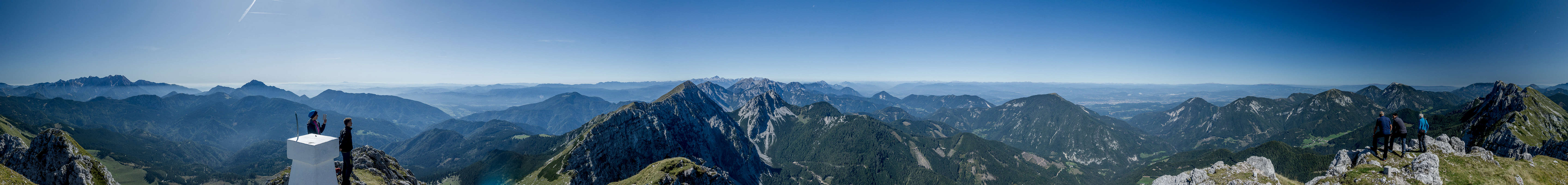
360° summit panorama Hochturm
It is a long hike which isn’t helped by our (except Vid’s) decision to cut a bend in the road short. Vid hikes on while we other three have to go up and up and up before our path vanishes and we are forced to descend along steep forest slopes. I lose the ladies and when I reach the cars Vid is already there. Jasmina and Judith join us five minutes later. We’re tired but it was an absolutely wonderful day.
The central mountains of the Kamnik Alps, seen while returning to the parked cars
This time we decide to drive the regular road back and it works well except for a narrow section, where a huge truck with an earth mover and another truck in tow comes the other way. Several cars have to go back and forth for a spot to hide themselves in but once the trucks have passed the road is clear. We split up at the gas station where we met. Thanks once more, Jasmina and, for introducing us into your mountains.
Parents refers to a larger category under which an object falls. For example, theAconcagua mountain page has the 'Aconcagua Group' and the 'Seven Summits' asparents and is a parent itself to many routes, photos, and Trip Reports.