
-
 3452 Hits
-
 76.66% Score
-
 7 Votes
|
|
List |
|---|---|
|
|
Overview
The Aosta Valley (Italy) is one of the most famous and beautiful mountainous countries in the world. It holds many impressive mountains like Monte Bianco, Monte Rosa, Monte Cervino (Matterhorn) and Gran Paradiso. But there are also many 3.500 meters peaks which are well known all over the world: For example the impressive Aiguille Noire de Peuterey and almost as impressive; Herbetet, Aiguille de Trélatête, Grivola, Mont Vélan, Becca di Luseney, Punta Tersiva and many others.
La Valle d'Aosta (Italia), è una delle più famose e belle regioni di montagna del mondo. Contiene molte montagne imponenti come il Monte Bianco, il Monte Rosa, il Monte Cervino (Matterhorn) e il Gran Paradiso. Esistono però anche moltissime vette di oltre 3.500 metri molto conosciute dagli alpinisti come l'imponente Aiguille Noire de Peuterey, l'Herbetet, l'Aiguille de Trélatête, la Grivola, il Mont Vélan, la Becca di Luseney, la Punta Tersiva e molte altre.
MAPS:
Ayas and Gressoney Valley
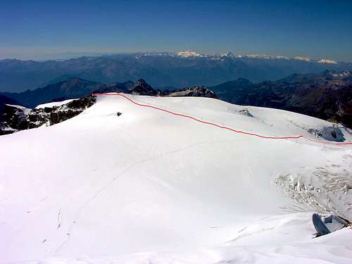 Gobba di Rollin 3.899m Gobba di Rollin 3.899mFirst ascent: Unknown.
Difficulty: F.
Difference in height: About 419m (from Testa Grigia 3.480m).
Refuge: -
Ascent time: 1,45-2,15 hours.
Descent: Along the ascent route.
Equipment: High mountain equipment: including rope, helmet, frontal torch, ice axe, and crampons.
|
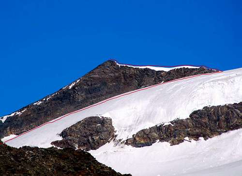 Punta Perazzi 3.906m Punta Perazzi 3.906mFirst ascent: (1930?).
Difficulty: F+/PD-.
Difference in height: About 1.235m (from Bettaforca Pass).
Refuge: Rifugio Quintino Sella, (3.585m). Places when open: 180. Winter hut: 35 places.
Ascent time: 5,00-5,30 hours.
Descent: Along the ascent route.
Equipment: High mountain equipment: including rope, ice axe, and crampons.
|
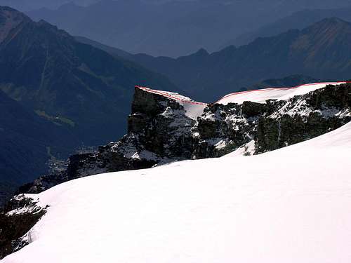 Torrione di Verra 3.738m Torrione di Verra 3.738mFirst ascent: Unknown.
Difficulty: F.
Difference in height: About 2.050m.
Refuge: Bivacco fisso Città di Mariano (2.830m), 9 places.
Ascent time: 6,30-7,00 hours.
Descent: Along the ascent route.
Equipment: High mountain equipment, including rope, ice axe, and crampons.
|
Refuges telephone numbers
- Rifugio GUIDE DELLA VALLE D'AYAS al Lambronecca 3.425m Tel. 0125-308083.
- Rifugio MEZZALAMA OTTORINO 3.004m Tel. 0125-307226.
- Rifugio QUINTINO SELLA 3.585m Tel. 0125-366113.
Books and Maps
BOOKS:- "Guida delle Alpi Occidentali" di Giovanni Bobba e Luigi Vaccarone C.A.I. Sezione di Torino Volume II (parte II), 25 Maggio 1896.
- "A piedi in Valle d'Aosta" (Vol. 2), di Stefano Ardito, Ed. Guide iter, Giugno 2004.
- "Guida dei Monti d'Italia" Monte Rosa di Gino Buscaini - Club Alpino Italiano/Turing Club Italiano, Maggio 2002 (In Italian).
 |
 |
 |
- Meridiani Montagne "Monte Rosa" Carta 1.50.000 con carta di dettaglio 1.20.000.
- L'Escursionista "Val d'Ayas Val di Gressoney Monte Rosa" Carta dei sentieri (n° 8) 1:25.000.
- Studio F.M.B. "Cervino Monte Rosa" Bologna 1:50.000.
- I.G.C. Istituto Geografico Centrale Torino "Monte Rosa Alagna e Macugnaga" (n° 10), 1:50.000.
- Kompass "Breuil/Cervinia-Zermatt" Carta turistica 1:50.000.
- I.G.C. Istituto Geografico Centrale Torino "Cervino e Monte Rosa" 1:50.000.
Important Information
- REGIONE AUTONOMA VALLE D'AOSTA the official site.
- COMPAGNIE DES GUIDES DE CHAMPOLUC - AYAS the official site.
- SOCIETA' DELLE GUIDE ALPINE DI GRESSONEY the official site.
- FONDAZIONE MONTAGNA SICURA Villa Cameron, località Villard de la Palud n° 1 Courmayeur (AO) Tel: 39 0165 897602 - Fax: 39 0165 897647.
- A.I.NE.VA. (Associazione Interregionale Neve e Valanghe).
Useful numbers
- Protezione Civile Valdostana località Aeroporto n° 7/A Saint Christophe (Ao) Tel. 0165-238222.
- Bollettino Meteo (weather info) Tel. 0165-44113.
- Unità Operativa di Soccorso Sanitario Tel. 118.