

-
 28845 Hits
-
 89.01% Score
-
 28 Votes
|
|
List |
|---|---|
|
|
DEGREE OF DIFFICULTY
A L P I N I S M
- F= Easy
- PD= Slightly difficult
- AD= Rather difficult
- D= Difficult
H I K I N G
- T= Tourist – Itineraries on footpaths, mule tracks or wide paths. Don't present orienteering problems.
- E= Excursion route without technical difficulty – Itineraries on footpaths or trails on different ground types (grassy meadows, rocky ground). Orienteering capacity and good training to walk some hours are required.
- EE= Trekking routes for expert hikers – Sign-posted itineraries with some difficulties: slippery, grassy or rocky ground, rocky or snowy slope or easy climbing passage (use of hands necessary). Only for experienced mountain hikers with at secure step, a good feeling for balance. Physical training for 1-day walk required.
- EEA= Trekking routes for expert hikers with equipment – Equipped tracks or "vie ferrate". Technical equipment required.
Alpine REFUGES
Denomination: Rifugio AGOSTINO E DELFO CODA (Punta Sella-Carisei)
Route: From Aosta (583m) - Nus (529m) - Châtillon (549m) - Verrès (391m) - Pont Saint Martin (345m) - Lillianes (655m) - Fontainemore (760m) - Refuge (2.280m)
Time: 2h'30 - 2h'45 from Fontainemore località Coumarial
Difficulty: E
Opening period: half July- half September
Owner: C.A.I. Sezione di Biella
Keeper: Famiglia Chiappo Rossini, Via Prealpi, 30 Occhieppo Superiore (Bi) tel. 015 590905
Refuge phone: 015 2562405
Places: 52
Local winter: places 8 always opens
Climbs and excursions: Monte Mars (2.616m), Cresta Carisei, Punta Sella (2.315m), Monte Bechit (2.320m), Monte Roux (2.318m)
Internet: Rifugio AGOSTINO E DELFO CODA
Email: -
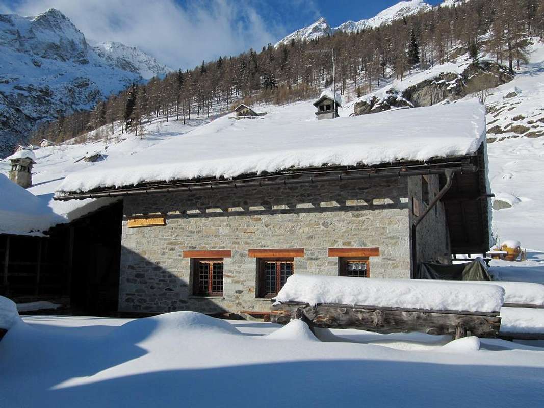
Denomination: Rifugio ALPENZU' GRANDE (Alpenzù Grande)
![]()
Altitude: 1.779m
Route: From Aosta (583m) - Nus (529m) - Châtillon (549m) - Verrès (391m) - Pont Saint Martin (345m) - Lillianes (655m) - Fontainemore (760m) - Issime (960) - Gaby (1.047m) - Gressoney Saint Jean (1.385m) - Chemonal (1.407m) - Refuge (1.779m)
Time: 1h'00 - 1h'15 from Chemonal (1.407m)
Difficulty: T
Opening period: half June - half September
Owner: Laurent Riccardo
Keeper: Laurent Danila, Località Bode, 10 Gressoney St-Jean (Ao) tel. 338 2562229
Refuge phone: 0125 355835
Places: 24
Local winter: places 6 always opens
Climbs and excursions: Testa Grigia (3.315m), Corno Vitello (3.057m), Monte Pinter (3.132m), Bivacco Lateltin (3.132m), Laghi di Pinter (2.692m)
Internet: Rifugio ALPENZU' GRANDE
Email: info@rifugioalpenzu.it
Denomination: Rifugio CITTA' DI MANTOVA (Ghiacciaio del Garstelet)
![]()
Altitude: 3.500m
Route: From Aosta (583m) - Nus (529m) - Châtillon (549m) - Verrès (391m) - Pont Saint Martin (345m) - Lillianes (655m) - Fontainemore (760m) - Issime (960) - Gaby (1.047m) - Gressoney Saint Jean (1.385m) - Gressoney La Trinitè (1.624m) - Arrivo telecabina Salati (2.970m) - Refuge (3.500m)
Time: 2h'30 - 2h'45 from arrivo telecabina Salati (2.970m)
Difficulty: EE
Opening period: half June - half September
Owner: Società delle Guide di Gressoney
Keeper: Società delle Guide di Gressoney Pres. Comune Paolo tel. 347 0802910
Refuge phone: 0163 78150
Places: 85
Local winter: places 9 always opens
Climbs and excursions: Punta Gnifetti (4.556m), Piramide Vincent (4.215m), Corno Nero (4.322m), Punta Parrot (4.436m), Punta Zumstein (4.563m), Punta Dufour (4.634m), Lyskamm (4.527m)
Internet: Rifugio CITTA' DI MANTOVA
Email: -
Denomination: Rifugio CITTA' DI VIGEVANO (Colle d'Olen)
![]()
Altitude: 2.863m
Route: From Aosta (583m) - Nus (529m) - Châtillon (549m) - Verrès (391m) - Pont Saint Martin (345m) - Lillianes (655m) - Fontainemore (760m) - Issime (960) - Gaby (1.047m) - Gressoney Saint Jean (1.385m) - Gressoney La Trinitè (1.624m) - Refuge (2.863m)
Time: 4h'00 - 4h'30 from Gressoney La Trinitè (1.624m)
Difficulty: T
Opening period: 04-Dicembre/30-Aprile - 25-Giugno/15-Settembre
Owner: C.A.I. Sezione di Vigevano
Keeper: Giuliano Masoni Bottone, Via Campolungo, 4/c Civiasco tel. 348 6976383 - 0163 55628
Refuge phone: 0163 91105
Places: 54
Local winter: -
Climbs and excursions: Punta Gnifetti (4.556m), Piramide Vincent (4.215m), Punta Giordani (4.046m), Balmenhorn (4.167m), Corno Nero (4.322m), Punta Parrot (4.436m), Punta Zumstein (4.563m), Punta Dufour (4.634m)
Internet:
Email: info@rifugiopastore.it
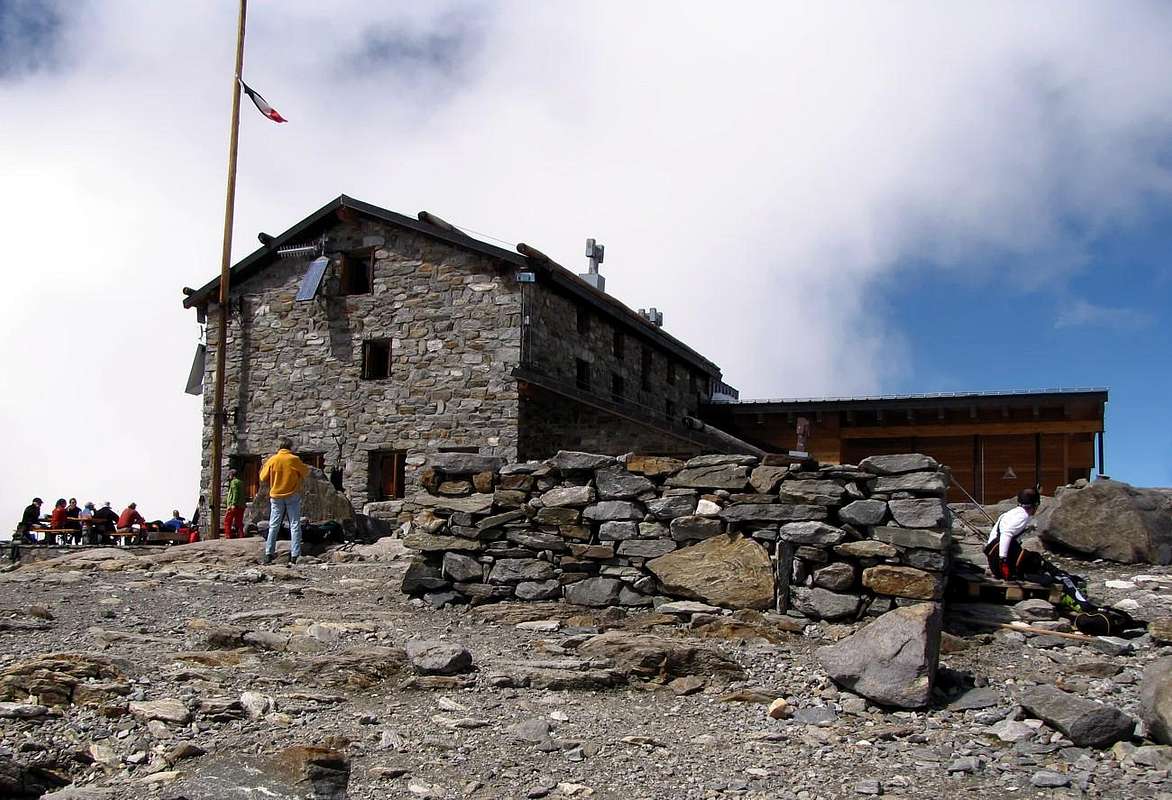
Denomination: Rifugio GIOVANNI GNIFETTI (Ghiacciaio del Garstelet)
![]()
Altitude: 3.647m
Route: From Aosta (583m) - Nus (529m) - Châtillon (549m) - Verrès (391m) - Pont Saint Martin (345m) - Lillianes (655m) - Fontainemore (760m) - Issime (960) - Gaby (1.047m) - Gressoney Saint Jean (1.385m) - Gressoney La Trinitè (1.624m) - Arrivo telecabina Salati (2.970m) - Refuge (3.647m) Time: 3h'00 - 3h'30 from arrivo telecabina Salati (2.970m)
Difficulty: F
Opening period: 04-Aprile/03-Maggio - 28-Giugno/06-Settembre
Owner: C.A.I. Sezione di Varallo
Keeper: C.A.I. Varallo Sesia, Via C. Durio, 14 Varallo Sesia (Vc) tel. 0163 51530/fax 0163 54384
Refuge phone: 0163 78015
Places: 178
Local winter: places 14 always opens
Climbs and excursions: Punta Gnifetti (4.556m), Piramide Vincent (4.215m), Punta Giordani (4.046m), Balmenhorn (4.167m), Corno Nero (4.322m), Punta Parrot (4.436m), Punta Zumstein (4.563m), Punta Dufour (4.634m)
Internet: Rifugio GIOVANNI GNIFETTI
Email: caivarallosesia@libero.it
Denomination: Rifugio del GABIET (Lago del Gabiet)
Altitude: 2.375m
Route: From Aosta (583m) - Nus (529m) - Châtillon (549m) - Verrès (391m) - Pont Saint Martin (345m) - Lillianes (655m) - Fontainemore (760m) - Issime (960) - Gaby (1.047m) - Gressoney Saint Jean (1.385m) - Gressoney La Trinitè (1.624m) - Arrivo telecabina Stafal (2.342m) - Refuge (2.375m)
Time: 0h'15 - 0h'20 from arrivo telecabina Stafal (2.342m)
Difficulty: T
Opening period: 08-Dicembre/15-Aprile - 15-Giugno/15-Settembre
Owner: Juglair Sandro
Keeper: Juglair Sandro, Località Plan de Brun, 29 Perloz (Ao) tel. 0125 806152
Refuge phone: 0125 366258
Places: 36
Local winter: -
Climbs and excursions: Corno Rosso (3.023m), Punta Straling (3.115m), Corno Grosso (3.042m)
Internet: Rifugio del GABIET
Email: info@rifugiogabiet.it
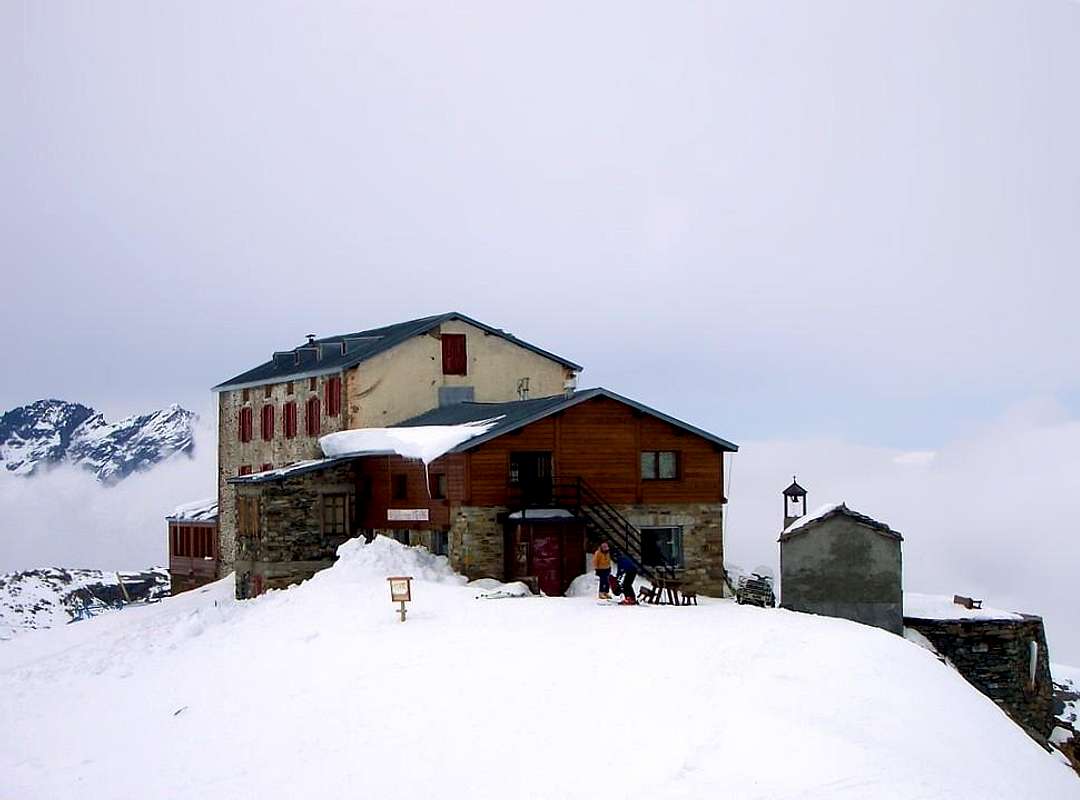
Denomination: Rifugio GUGLIELMINA (Col d'Olen)
![]()
Altitude: 2.866m
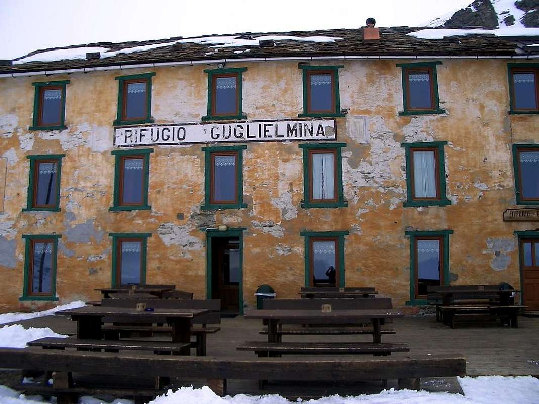
Route: From Aosta (583m) - Nus (529m) - Châtillon (549m) - Verrès (391m) - Pont Saint Martin (345m) - Lillianes (655m) - Fontainemore (760m) - Issime (960) - Gaby (1.047m) - Gressoney Saint Jean (1.385m) - Gressoney La Trinitè (1.624m) - Refuge (2.866m)
Time: 4h'00 - 4h'30 from Gressoney La Trinitè (1.624m)
Difficulty: T
Opening period: 16-Novembre/20-Aprile - 20-Giugno/20-Settembre
Owner: Famiglia Guglielmina
Keeper: Calaba Alberto, Località Gaby Desor, 23 Gaby (Ao) tel. 347 2732082/fax0125 345107
Refuge phone: 0163 91444
Places: 50
Local winter: -
Climbs and excursions: Punta Gnifetti (4.556m), Piramide Vincent (4.215m), Punta Giordani (4.046m), Balmenhorn (4.167m), Corno Nero (4.322m), Punta Parrot (4.436m), Punta Zumstein (4.563m), Punta Dufour (4.634m)
Internet: Rifugio GUGLIELMINA
Email: rifugioguglielmina@libero.it
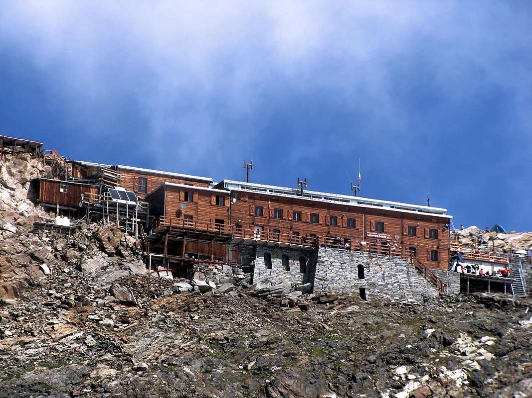
Denomination: Rifugio QUINTINO SELLA (Ghiacciaio del Felix)
![]()
Altitude: 3.585m

Route: From Aosta (583m) - Nus (529m) - Châtillon (549m) - Verrès (391m) - Pont Saint Martin (345m) - Lillianes (655m) - Fontainemore (760m) - Issime (960) - Gaby (1.047m) - Gressoney Saint Jean (1.385m) - Gressoney La Trinitè (1.624m) - Bettaforca Pass (2.672m) - Refuge (3.585m)
Time: 3h'30 - 4h'00 from Bettaforca Pass (2.672m)
Difficulty: EE
Opening period: 15-Aprile/05-Maggio - 20-Giugno/15-Settembre
Owner: C.A.I. Sezione di Biella
Keeper: Adriano e Alfredo Favre, Frazione St. Jacques, Ayas (Ao) tel. 0125 307263 - 348 8107793
Refuge phone: 0125 366113
Places: 142
Local winter: places 26 always opens
Climbs and excursions: Castore (4.226m), Punta Perazzi (3.906m), Lyskamm Occidentale (4.481m), Lyskamm Orientale (4.527m)
Internet: Rifugio QUINTINO SELLA
Email: felix@tiscalinet.it
Denomination: Rifugio REGINA MARGHERITA (Punta Gnifetti)
![]()
Altitude: 4.556m
Route: From Aosta (583m) - Nus (529m) - Châtillon (549m) - Verrès (391m) - Pont Saint Martin (345m) - Lillianes (655m) - Fontainemore (760m) - Issime (960) - Gaby (1.047m) - Gressoney Saint Jean (1.385m) - Gressoney La Trinitè (1.624m) - Arrivo telecabina Salati (2.970m) - Refuge Gnifetti (3.647m) - Refuge (4.556m)
Time: 4h'00 - 4h'30 from Refuge Gnifetti (3.647m)
Difficulty: F
Opening period: 28-Giugno - 06-Settembre
Owner: C.A.I, Sede Centrale
Keeper: C.A.I. Sezione di Varallo, Via C. Durio, 14 Varallo Sesia (Vc) tel. 0163 51530/fax 0163 54384
Refuge phone: 0163 91039
Places: 81
Local winter: places 15 always opens
Climbs and excursions: Punta Zumstein (4.563m), Punta Dufour (4.634m), Punta Norden (4.609m), Lyskamm Occidentale (4.481m), Lyskamm Orientale (4.527m)
Internet: Rifugio REGINA MARGHERITA
Email: caivarallosesia@libero.it