
-
 5817 Hits
-
 71.06% Score
-
 1 Votes
|
|
Route |
|---|---|
|
|
46.43420°N / 14.17910°E |
|
|
Mountaineering, Scrambling, Skiing |
|
|
Spring, Summer, Fall |
|
|
Most of a day |
|
|
Walk-up |
|
|
Rating the Route (by Hiking Standards)
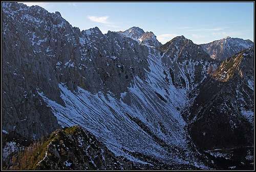
The end of Poden/Bodental
0. General: From 1052 m to 2236 m. Steep, non-marked path, screes. Quite some effort needed on soft screes below the Vrtača saddle and the saddle between Mali and Veliki Stol. Exposition north and east. Gear: good shoes, poles. This route is useful for a descent, because of soft screes below both saddles (altogether you can comfortably slide down some 500 m of altitude!). Overall difficulty on the Swiss Hiking Scale would be T3.
1. Effort: 1240 m, 4h.
2. Power: 1 - no difficulties, only walk-up.
3. Psyche: 1 - no difficulties (in winter, if icy, these slopes could be steep).
4. Orientation: 2 - easy, you have to find only the trail to the screes below Vrtača/Wertatscha.
Approach
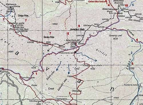
The trailhead starts in Poden/Bodental, 1052 m. You reach this beautiful valley from the main road which goes over Ljubelj/Loibl pass (deter from it on the Austrian side). See also the main page.
Route Description
Stol and its routes
From the last parking place in Poden / Bodental you continue by the marked path towards the south. In some 20 minutes it reaches the beautiful Mlaka / Maerchenwiese. From there continue towards the south, but just before reaching big screes below Vrtača / Wertatscha north face, you leave the marked path. It turns a bit towards the right, ascending through the woods on Vrata pass and further to Celovška koča / Klagenfurter Huette. We continue straight towards the south and soon reach the big screes. Here the difficulties start.
Over those screes there goes no path. In summer rarely anyone ascends there. It's much different in winter and spring, when there many tour skiers ascend and ski down. In summer go directly up and towards the right until you hit the path, coming from the right. Ascend by it to the clearly seen Vrtača saddle, 1845 m. On our right is Svačica, 1953 m, on our left is the long west ridge of Vrtača. From the Vrtača pass you first cross the southern slopes of Svačica and so in few minutes reach the Belščica pass, 1840 m. Here you hit the marked path from Celovška koca / Klagenfurter Huette. Follow it into V Kožnah basin and up to the summit of Stol, as described in route description 'From Klagenfurter Huette Over Belscica'.