
Comments
No comments posted yet.
|
|
Trip Report |
|---|---|
|
|
19.17860°N / 98.64188°W |
|
|
Download GPX » View Route on Map |
|
|
Jul 16, 2021 |
|
|
Hiking, Mountaineering |
|
|
Summer |
In classes, we were asked to carry out a small investigation of some type of vegetation existing in Mexico. The alpine zacatonal, by many factors, has been almost completely ignored, looking at most like the golden carpet that mountaineers cross, preceding the barren and dark soils of the volcanic peaks, frequently topped with white veils of snow, and plump glaciers. It was the sufficient pretext to convince, with more ornaments, a colleague, who would help me with the transport to the field of study, which would greatly facilitate the work. We would form a work team, documenting the National Park botanically and geologically, without forgetting brief interviews with site personnel and visitors, quite heterogeneous in their objectives and origin. I had been waiting months for the opportunity to ascend a new, and more challenging mountain.
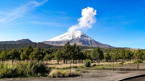
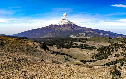
Izta-Popo is the jewel of the National Parks in Mexico, a huge polygon that houses a forest massif in good conditions of conservation, with a high botanical and fauna richness. This biodiversity, as biologists affirm, is the product of the conjugation of an extremely rugged topography, which separates two basins, that of the Lerma and the Balsas; a division that also separates the lands mainly influenced by the Arctic, from those with the predominant tropical element. The highest peaks of the park are Popocatépetl and Iztaccíhuatl, the first with ~ 5462 meters above sea level, and the second with 5230 meters above sea level. But Popocatepetl is one of the most dangerous active volcanoes in the world, so access is restricted. In that case, it is the "sleeping woman" who gets the title of the second largest scalable summit in the republic. Her iconic silhouette resembles that of a sleeping woman, wow, and this has sparked mythical and legendary explanations from the Mexican ancestors. The base camp to travel the common route "of the feet" is called "La Joya", at more than 4000 meters above sea level, further on from the border of the forest with the zacatonal. However, the first step to get to that camp is to pay the regulatory fee (50 pesos per person during the week) and register (without reservation from Monday to Friday) at the Paso de Cortés booth, the mountain pass between the Izta and the Popo.
Fortunately, my partner had enthusiastically agreed. He had a car, he was older than me, and he had the concern of climbing a mountain. I assumed that he would not make it, for lack of acclimatization. The risk, as always, was worth enough to risk his life at any given moment. Since I left Texcoco at 7 in the morning, July 16, I knew that things would go well. The weather was behaving more or less as the forecast predicted: it was a warm morning with a pleasant wind. It was Friday, and I was listening to my virtual classes as my partner drove over the turbulent outskirts of Mexico City. He knew the area well, and had given her instructions days before. At a quarter to eight, the volcanoes, with their snow-capped peaks, loomed on the horizon, getting bigger and bigger, and the Tláloc-Telapón, formerly imposing on the east, now reduced to high, long and progressive plateaus. We had to have breakfast in Amecameca, before deviating towards the Paso de Cortés, crossing the road surrounded by the oyamel forest, to the pine forest that ends at the entrance of the National Park. After paying, I made my first weather observations. It was nine o'clock in the morning, the wind was blowing strong first, causing the thermal sensation to oscillate 8 ° C. After my partner had experienced wading across the dirt road, we arrived at La Joya, parking the car conveniently facing south.
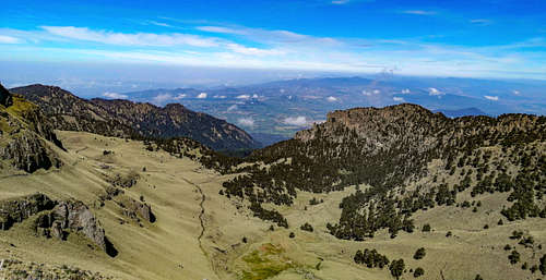
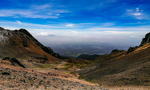
After the photographs of some plants in the vicinity, we distinguish the top of Izta as a soft white dome like a seasonal glacier in the process of extinction. After entering the path properly, passing several tourists, came the first uphill, a 30 ° slope, which led to the true slopes of the set of domes. My partner couldn't handle that effort right away, given the lower oxygen availability at those elevations (certainly, it's important to be acclimatized or at least have experience above 4000 meters above sea level). I continued on my own, as planned, at a slower speed, also acclimating my body to the effort of using my lungs at that rate. In fact, I quickly took a break, put my jacket away, and advanced to a better pace. The beautiful views of Popocatepetl were not lacking, firing incipient fumaroles. I successively crossed several "gates", distinguishing the vegetal formations and some important species, documenting the data of their altitude and coordinates with the GPS receiver. At 4,700 meters above sea level, in fact, the vegetation disappeared, increasing the amount of stones and the exposure of the soils, now subject to periglar conditions. There was no special precaution, more than directing my feet well, poorly covered with desert boots, but with Gore-Tex socks. I took out my glasses, because as noon approached (I had left La Joya at 10:00), the nearby whiteness had a true “mirror effect”. I was reassured, however, by the great availability of water, in snow that would melt in my canteen. It had taken me about five breaks until I reached the “Refuge of 100”. It should be said that, in numerous steps, I was able to make out the Xinantécatl, from the same panorama that it shared with the camp, hundreds of meters below. In an old glacial cirque, truly concave, the very Pico de Orizaba could be distinguished, very far away, only showing off its snowy, conical summit. From "La Malinche", also in Puebla, you could only see its secondary summit, 3800 meters above sea level, elongated like a spur.
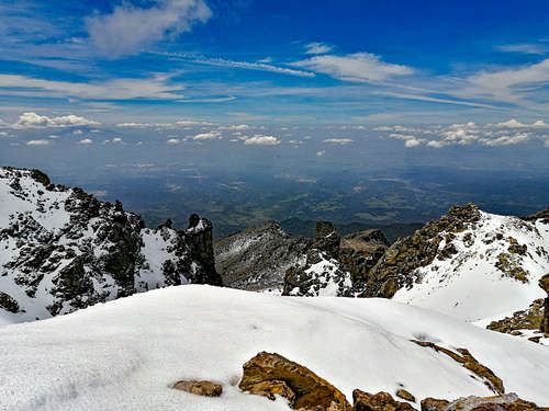
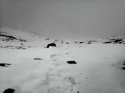
After seeing the “Refugio de los 100” below, I noticed the main difficulty in the ascent: a heavy slope of approximately 35 ° that covered 300 m of unevenness, until it exceeded 5000 meters above sea level. I rested while photographing the scene getting my location and elevation at the same time. I put on the windbreaker, and began to climb where you could see the marks made by the boots and poles of the past days. 100 m I advanced well, but I was looking down, and I was concerned to keep my eyes straight ahead or, rather, up. The snow had first been like a carpet, but with the elevation gain its accumulation also increased. Crampons did not necessarily merit, as the feet sank to 50 cm in the last part of the slope, hindering progress, and also holding the body to the icy surface.
Altitude sickness never appeared in any symptom, but fatigue did overwhelm my mind. Upon reaching 4,900 meters above sea level, a real achievement for me, I considered the possibility of going back, as I still had 100 m to go to reach a good point to base the reach of the top. Also, the weather had gotten too bad, preventing me from being guided by the topographic features. But I checked the GPS, and slowly I kept going, until I reached 5100 meters above sea level, the end of the slope. It was slightly past noon. The snowfall came sometime after I continued down the narrow ridge. I wasn't really cold, I was sweating with a tension that was based on my lack of materials in the face of the storm. I did not want to stop at the extinct Ayoloco glacier, invisible for the most part, in favor of covering the final attack on the summit. The GPS was well protected by the indicator in my pockets, so its performance was not affected. The temperature was pleasant, barely touching -3 ° C.
The storm that clouded the landscape prevented me from appreciating the slope and length of the last stretch, and in a long half hour I reached the summit, mostly by force of will. The GPS marked 5230 meters above sea level. It was 1:30 p.m. I could only locate myself properly by the crosses, so Catholic Mexican, that with posthumous dedications and prayers they remembered the efforts of some people who had died in the attempt, or some of so many journeys. I was not moved, unfortunately, I was urged to return. For the first time I seriously wondered how I would get back, that was what worried me the most, and that my partner was also relaxed in the car. I had not anticipated being locked in the storm, I regretted not having seen the highest panorama of the Valleys of Mexico and Puebla. It was a lot to ask for an extraordinarily benign year in case of rains. Following the irregular line that the GPS had drawn turned out to be very fast, being able to descend also helped by the reduction of the risk of suffering a serious fall. The wind was not strong.
I quickly assumed that, for it to be summer, I had run with luck to have found knee-deep sunlight until noon. Going down, very carefully step by step, I finally went down to 4900 meters above sea level, where I took snow to melt it in my canteen. I heard some shouts, not for help, but for calls or greetings. They must have come from the Refuge of the group of 100, 200 m below. Up to the middle of the slope I could see them in the distance, in a fleeting clarity that the clouds granted.
The situation turned out to be worrying: the snow was melting very quickly, quickly finding runoff paths in human footprints and seasonal streams formed by erosion of thousands of years. Somewhere to the northwest of the mountain, on some rocky ends that ended in gorges, you could see the waterfalls of melt water. It was approaching 3 in the afternoon, the hottest hour, and since the snows were no longer perpetual, they were very susceptible to changes in temperature. As it was going down, I increased my speed, and it did not take me long to meet the group that had stopped at the shelter. We exchanged a brief dialogue, in which I learned that his plans to climb had been thwarted, of course, by the storm. The serenity and resignation with which they told me, even with humor, reassured me.
The desert boots had given me the lightness necessary for the hike at high speed and without worrying deeply about the conditions of much of the terrain, sandy and desert volcanic. The backpack, barely 23 lt, explained to a great extent the speed that I developed without wearing myself out, carrying only what was necessary for the day, without even exceeding 5 kg (a true attack backpack).
I went down quickly, skirting an old glacial cirque that with the advent of the rainy season received the hilarious name of "La Jabonera", alluding to the slippery properties of wet soap in the bathroom. Boots performed at their best here. My feet hadn't gotten cold from the constant stress, on the contrary, the drainage holes did a good job of ventilation. The pants quickly dried, dissipating my body heat, as the DWR coating had clearly been bypassed. Little more than an hour was what it cost me to go down 1000 m of unevenness. When I got to the pasture, my worries were dispelled. It was not difficult for me to get to the parking lot, where my colleague was resting peacefully. It was 3:30 p.m., with the sun far behind the storm that hid the mountains.
I had to quickly sort my wet clothes, changing with the spare parts left in the car. It was not worn, mainly due to stress management and brief exposure to strong natural phenomena. I lost several kilograms, yes.
In conclusion, it was an excellent route to achieve a first ascent, although a greater number of protection elements would have been ideal for any unforeseen of greater magnitude. It is not advisable to make ascents alone, unless you can cover the technical capabilities of a simple expedition in the high mountains. Perhaps, more slowly and in a season like winter, better views and more difficult ascents will be achieved due to the presence of ice instead of snow and the whipping of the winds. I cannot rule out that a part of the vertigo that I did not feel was possibly prevented by the cloudiness, as an additional blanket to the dark glasses.
Some additional data on temperature and humidity were collected before returning to interview people in Amecameca, now safe from the summer rains.