
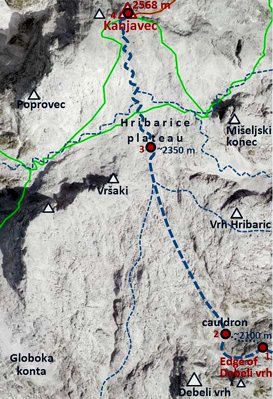
-
 5202 Hits
-
 79.78% Score
-
 11 Votes
|
|
Route |
|---|---|
|
|
46.36060°N / 13.81460°E |
|
|
Skiing |
|
|
Spring |
|
|
A long day |
|
|
middle |
|
|
Introduction
The ski tour from the summit of Kanjavec (the highest tour ski summit in Julian Alps, extreme tours excluded) down into Bohinj valley is one of the greatest in Julian Alps. It can offer you more than 2000 altitude meters of continuous skiing, with some flat sections on the upper meadows. The scenery is great, the views from Kanjavec almost endless.
The tour "Behind Debeli vrh" is described here as an ascent. You ski down in the reverse description. The tour can be combined with any of other ski descents which end on the Blato alpine meadow. It represents the shortest ski ascent from Bohinj on Kanjavec.
General Information
Difficulty: It's a medium difficult ski tour. Technically, there are no really steep sections, but the tour is very long and if weather conditions deteriorate, orientation can get problematic.
Ascent time: From Bohinj count with good 6 hours, if you start on Blato meadow, count with good 4 hours. Those are net times of walking up, as the tour is long, allow also some time for rests!
Orientation: The tour is popular, so it's likely that we'll have a track, at least to Laz meadow. If not, orientation can be difficult. The woods above Blato meadow offer only little orientation points, and the section from Lazovški preval to Hribarice plateau can be in poor visibility very dangerous (no marks)!
Exposition: There's no serious danger of fall or more exposed slopes. The last meters below the summit of Kanjavec are steeper, but not exposed.
Slopes orientation: The slopes are mostly south oriented, but in various sections all other orientations occur. Till the edge of Debeli vrh the slopes are east oriented, the crossing behing Debeli vrh is north oriented.
Objective dangers: In deep fresh snow better don't undertake the tour. Many sections are exposed to avalanches, not only in higher areas. In Slovenian mountains avalanche risk report (on the international 5-points scale) is issued every day.
Best months: The tour can be done throughout the whole winter and spring, but usually it's safe to undertake it between March and start of May. Depending on how rich with snow was winter and what are the conditions. It's ideal to catch the time, wjen the road to Blato is already cleaned. That saves you 2 h of ascent time (600 m of altitude).
Gear: Only usual gear for tour skiing. A good map and GPS are almost mandatory.
Mountain huts support: None.
Lowest altitude: Bohinj, 551 m or Blato meadow, 1147 m.
Highest altitude: Kanjavec, 2568 m.
Approach To Blato Meadow
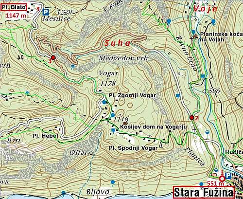
The tour starts in Bohinj valley, by the lake, 525 m, or in the village of Stara Fužina, 551 m (1). At the end of the village ther's the summer parking place. During the tourist season there the road is closed (you need to pay toll). In winter conditions it may be opened, depending if it's cleaned.
From there follow the road towards the north, in Voje valley. After 1500 meters the road branches (2). Take the left forrest road, which will take you into the Suha valley (the right one continues into Voje).
Already in the lower part of Suha valley the road crosses the creek and proceeds over slopes on the northern side. Approaching the end of Suha valley the road gains with a few curves much of altitude and above the valley branches again (3).

Blato alpine meadow
The left branch goes to Vogar, while we take the right branch and proceed by it till Planina Blato (alpine meadow), 1147 m (4). In winter this road is not cleaned, so you can expect to drive up by car only if snow conditions are poor, or in spring, when snow stays only on higher parts of mountains. From Stara Fužina to Planina Blato you need 2 hours of walk up.
Route Description
From Blato To Laz
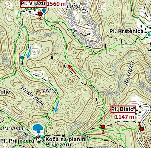 |
Some 200 meters before Blato, 1147 m, (1) marked path leaves the road and goes towards the west. Laz meadow It climbs over a steep passage and above it follows natural passages through the woods. If you miss the route here (if in winter you don't find marks) you soon find yourself in wilderness, where it is very difficult to orient and also proceeding is very difficult. Anyway, the direction is north, only later it turns slightly towards the north-west. So you reach Planina v Lazu, 1560 m (3), a beautiful, big alpine meadow among Kreda, Ogradi and Debeli vrh. From Planina Blato 1 h 30 min if snow is good for walking. |
From Laz Below Debeli Vrh
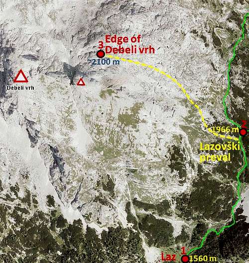 |
 The eastern slope of Debeli vrh 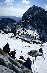 Near the edge below Debeli vrh |
From Below Debeli Vrh On Kanjavec
 |
 Crossing the slopes below Debeli vrh  On Hribarice - Vršaki As we are approaching Hribarice, the summit of Kanjavec rises more and more on the horizon ahead of us. It has two almost equally high peaks. Crossing Hribarice is fast and we continue by a shallow valley between both peaks of Kanjavec. In good conditions we still keep skis on feet, but the slope gets steeper and steeper. Careful turns, choosing best inclination and we reach the summit ridge. Higher is the right (eastern) summit of Kanjavec, but do visit both! From the edge below Debeli vrh 2 h. |
Skiing Down
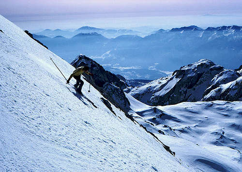
From the very summit of Kanjavec
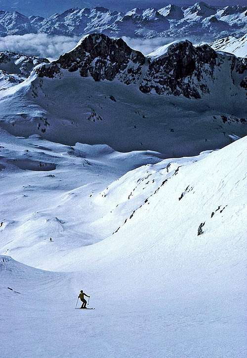
The shallow summit ravine to Hribarice
You best ski down by the ascent route. The last map above shows how the ski descents are branching.
Reaching Hribarice, you can continue westwards into the Valley of Triglav Lakes, or eastwards, into the Velska dolina (valley). These two routes will NOT bring you down on Blato meadow!
The next option is skiing south of Mišeljski konec and then very steeply eastwards down into Mišeljska dolina. If you leave that valley in the middle, you can get over the Mišeljski preval on Jezerce meadow and from there further down on Krstenica and Blato.
Next option deters from our route a bit later, when we are paralelly to the summit of Vrh Hribaric. We can deter eastwards, cross it and continue skiing below the southern side of Škednjovec. That brings us down on Jezerce as well.
Finally, we can on the same place keep more towards right (westwards). Keeping a bit west of the ridge, which goes on Debeli vrh, we can ski on Laz meadow by the route, called "In front of Debeli vrh". A bit more difficult orientation, though.
But our normal route goes from Hribarice by a shallow valley down towards Debeli vrh. Make sure that the distinct, rounded ridge which ends with the steep northern ridge of Debeli vrh, stays on your right. When in the cauldron below Debeli vrh, chose the best option to ascend the edge above (2100 m), then continue joyful skiing on Lazovški preval and right down On Laz meadow.
From Laz, it is recommended to continue skiing southwards, by the marked route to planina Pri jezeru. Nice passages and a slight ascent will bring you around the hill of Huda rupa, 1622 m. From Pri jezeru meadow you continue eastwards, by a cart road and clearings down on Blato meadow.