Trip Report
What is the first thing you think about when the mercury in the thermometer creeps up past 90 degrees? Grab your swimsuit and head for the lake? Go catch a matinee show at an air-conditioned movie theater? Carry a heavy backpack up miles of steep mountain trail during the hottest part of the day? Why, the heavy backpack of course! Who's with me? Hey…where is everyone going?
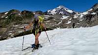
![Glacier Peak from White Chuck Glacier]() Glacier Peak
Glacier PeakAs luck would have it there were two gluttons for punishment, Shawn and Brenda, who also thought climbing Glacier Peak was a great way to spend a record hot Fourth-of-July weekend (in fact it was Shawn's plan). Although it is a "walk up" and not technically difficult, Glacier Peak is one of the less climbed of the Cascade volcanoes due to its remote location in the heart of the eponymous wilderness area. From trailhead to summit it is over seventeen miles. Of the popular mountains to climb in Washington only the hike to the summit of Mount Olympus in the Olympics is longer.
![Mountain Loop Highway Sign]() Mountain Loop Highway
Mountain Loop HighwayJust to make it more of a challenge we were going to do it in two days—most people do it in three. When Shawn proposed climbing Glacier Peak over the three day Fourth-of-July weekend I was in favor of doing it in two days, so that I could have my Sunday at home, but was open to three days. With Brenda along we had to do it in two days because she owns a horse and needed to be at the stables before the fireworks on the Fourth started. Just like a dog, a horse will get spooked by fireworks, so Brenda needed to be there to keep her horse calm and give it a sedative.
The morning of Friday, July 3rd we left Seattle at 6 a.m. headed for the Sloan Creek campground, the trailhead for Glacier Peak. The turnoff for Sloan Creek is at the far end of the Mountain Loop Highway. As the name implies the highway is a loop so if you are driving to the Sloan Creek campground you can take the northern loop via Darrington or the Southern loop via Verlot. Even though it seems farther from Seattle the Darrington route is a little faster because it is more direct. You avoid the multiple connecting state highways and traffic lights from I-5 to Granite Falls.
![Oso Memorial]() Oso Memorials
Oso MemorialsOn the way to Darrington we passed through Oso where we stopped briefly. I have not driven through since last year's disaster. March the year before a hillside collapsed, creating a huge mudslide that blocked the highway, destroyed dozens of homes, and killed forty-three people. The wreckage has long since been cleared away, but the gate to the site is decorated with memorials to the victims. It was shocking to imagine that so many died there.
The previous winter had been the warmest on record with the snow pack in the Cascades at record lows. This not only meant we had a terrible ski season, but also long term consequences for the water supply for both humans and nature. In the maritime Northwest summer doesn't usually start until after the Fourth-of-July and it is not unusual for the Fourth to be overcast and drizzly, but all of June this year was hot and dry. In Seattle lawns had already died, conditions looked like they do after Labor Day in early September. On the drive to the trailhead it was the same late-summer conditions as in the city, the roadsides were covered with dead grass turned yellow. The tinder-dry conditions had led to predictions of forest fires in the news and one of my friends even commented that I should hope we do not get trapped on the mountain by a fireworks triggered fire. When we arrived at the trailhead I was pleased to see that it was still a lush green.
![North Fork Sauk Trail, F.S. #649]() Old Growth Forest
Old Growth ForestWhen researching the climb there were few Glacier Peak trip reports on the Internet so I got it into my head that there was not going to be a lot of people climbing. I was totally wrong, the parking lot at Sloan Creak campground was overflowing. We had plenty of company on the trail including Dave Wheeler from BOEALPS and some of his "Ascenders in Suspenders" teammates from this year's basic climbing class. It made sense; most people take three days to climb Glacier Peak so the three-day Fourth-of-July weekend was a perfect time to climb it.
Temperatures in the Puget Sound region were forecasted to be in the low nineties for the weekend and at 9 a.m. when we started hiking it was already warm at the trailhead. The first five and a half miles of the trail to the Mackinaw shelter were easy going, gaining only a thousand feet of elevation through the shady old-growth forest that runs parallel to the North Fork of the Sauk river and crosses numerous creeks. I was pleasantly surprised that this area was never logged and still retained so many big trees. Most stands of old growth I've seen are usually in steep areas not easily accessible to old time loggers.
![Switchbacks to White Pass]() Switchbacks
SwitchbacksAfter Mackinaw shelter there are a series of switchbacks that climb over two thousand feet of elevation in less than a mile. Reading the map I thought we would be ok and in the shade the whole way up because the switchbacks are below the timberline. I was totally wrong. The switchbacks follow a path through mostly open brush with only intermittent clumps of trees for shade. We hit the switchbacks a little past, just in time for the hottest part of the day. The sun was directly overhead and there was absolutely no breeze. In the far too few patches of shade other groups of climbers were stopped to take shelter from the heat. I was sweating like a pig and by the end of the day I had white salt stains on my clothes from heavy perspiration. It would end up being the worst part of the whole approach hike. Both Shawn and Brenda were wearing sunshirts with hoods and I was jealous.
![Ice cold spring water]() Cold Spring Water
Cold Spring WaterIt was hot enough that the hard work of hiking with backpacks made heat stroke a possibility. By the time we got to the top of the switchbacks the heat was getting to me and I was unsteady on my feet. I recently reread the science-fiction novel
Dune for the first time since high school some thirty years ago and I was thinking about it as the hot sun was beating down on me. Dune holds up really well, it is one of the best science-fiction novels ever written. I was also surprised how relevant it still feels today, especially considering that it was published fifty years ago. Ecology is a big theme of the novel; the desert planet Dune was once a water planet like earth and the Fremen, the native people of Dune, are secretly working to restore the planet's environment. There was also a lot of talk of jihad in the book as the Fremen, lead by Paul Atreides, work to overthrow the empire that oppresses them. Sipping water out of my CamelBak drinking tube while hiking up the switchbacks in the sweltering heat I could have used a hooded Fremen
jubba cloak for protection against the sun and a Fremen
stillsuit to conserve my water.
![Cold Spring Water on a Hot Day]() Brain Freeze!
Brain Freeze!There was no water on the switchbacks, but just past the end of the switchbacks we found a small trickle of ice-cold spring water. We all took turns filling up our water bottles and dumping them on our heads. It felt amazing and gave all of us a second wind. Both Shawn and Brenda drank straight out of the spring without filtering the water. I was tempted, but used Aquamira drops to treat my water instead. I was sorely tempted to drink the water untreated. I know how good cold spring water tastes, but I've had giardia before and let me tell you it is no fun. You only need to have it once to never want to risk getting it again. Later at our camp Shawn drank snowmelt water directly too. I asked both of them about it a couple weeks after the climb and neither got sick. Still I would not recommend it, better safe than sorry.
![Wild flowers near White Pass]() White Pass Wildflowers
White Pass WildflowersPast the switchbacks is a long traversing hike that briefly joins up with the Pacific Crest Trail until White Pass. This is an area of beautiful alpine meadows in full bloom; real "The hills are alive with music" country. At the pass Brenda indulged an arms spread out twirl
a la Julie Andrews in
The Sound of Music. After White Pass the approach to Glacier Peak continues on the Foam Creek Trail until it runs out. This is where the maintained trail ends and the climbers' path to White Chuck Glacier begins. At the turn off there is a cairn and someone helpfully made an arrow out of small stones to point the way.
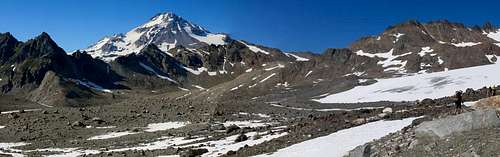
On the way to our camp we had to lose elevation and climb back up again three times which I was not stoked about. The first was a traverse into a steep valley on the Foam Creek side, then after passing over a saddle we dropped down again into a boulder filled basin, then up again only to descend down the final time to the White Chuck Glacier. The White Chuck is a fascinating landscape dotted with dozens of meltwater pools sitting on top of the ice and snow, crisscrossed by a hundred tiny streams, ornamented with small waterfalls, and punctuated by large glacier-rounded boulders. It was landscape unlike any I have experienced before and I thought it was pretty cool—like something out of a fantasy novel. However it is disturbing too—the White Chuck is a dying glacier and will soon be gone. When you compare the photo of the big healthy looking White Chuck Glacier in the Beckey guidebook (see references below) compared to the emaciated remnant we encountered the change is stark. Most people who are climbing Glacier Peak in three days camp at White Chuck, but we pushed on to Glacier Gap because we wanted to camp as high as possible to shorten our summit day.
We had high steep snow traverse to Glacier Gap as our final challenge for the day. We arrived at our Glacier Gap campsite at 7 p.m. This was later than I was hoping; I wanted to be asleep by 8 p.m. There are only about four good campsites at Glacier Gap, so we were lucky that one was free, as the others were taken. There were some snowmelt streams near camp for water.
![First view of Glacier Peak]() First view Glacier Peak
First view Glacier Peak | ![The melting White Chuck Glacier]() Melting White Chuck Glacier
Melting White Chuck Glacier | ![Approaching Glacier Gap]() Approaching Glacier Gap
Approaching Glacier Gap |
Getting to Glacier Gap was thirsty work and we were all in need of replenishing our water supplies. By the time we got to our campsite I drank four liters of water. Brenda had four liters of water too and Shawn drank five. This is the most water I have ever had to drink on an approach hike in the Cascades or almost anywhere. The last time I drank this much water on an approach hike was in Morocco in 2003 when I hiked Jebel (Mount) Toubkal. I hiked from the town of Imlil to the Toubkal Refuge at the base of the mountain on a very hot June day and drank 5 liters of water on the way.
It was a nice campsite with some good views, not that we had a lot of time to enjoy it. We had to get our gear ready for the morning, get water, wolf down dinner, and crawl into our sleeping bags at 9 p.m. Instead of a tent I was using a bivy sack that I was able to borrow from one of Shawn's friends. I do not love sleeping in bivy sacks, but I did love how light it was in my pack—only fifteen ounces!
![Moonlit Gerdine Glacier]() Moonlit Gerdine Glacier
Moonlit Gerdine Glacier | ![Cool Glacier]() Cool Glacier
Cool Glacier | ![Disappointment Peak]() Disappointment peak
Disappointment peak | ![Glacier Peak s Shadow]() Glacier Peak's Shadow
Glacier Peak's Shadow |
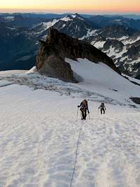
Not like we really got much sleep. We were making an alpine start so the alarm went off at 12:45 a.m. I was not thrilled to be awake, but at least it was a beautiful night. There was not a cloud in the sky and we had a nearly full moon to light our way when we started hiking at 1:30 a.m. It was warm too; the freezing level was fifteen thousand feet. It was a very pleasant temperature and the snow was firm, but not frozen.
![Dirt Ramp to Glacier Peak Summit]() Dirt Ramp to Summit
Dirt Ramp to Summit I was glad we started when we did, that hike would have been a hell of a lot less fun with a hot sun beating down on us and the snow turning to mush under our feet.
As we reached the edge of the Gerdine Glacier it was still night and the bowl of the Big Dipper constellation was pointing directly at the summit of Glacier Peak. The route to the summit was very straightforward. It is exactly like the photo in the Beckey guidebook. There is a dirt ramp you ascend on the climber's left side of the Gerdine Glacier. When you can no long travel on the dirt ramp you continue on the left hand side of the Gerdine until you are at the same level as the saddle over to the Cool Glacier. This is where we roped up, for the traverse across the top of the Gerdine Glacier. We did want to be too high on the Gerdine because there was significant rock fall debris littering the top end of the glacier from where it abuts some cliffs. Some rocks even came down right while we were traversing the glacier near the rock debri It was a sound that made my heart skip a beat.
![Forth-of-July on Glacier Peak Summit]() Summit of Mount 'Merica!
Summit of Mount 'Merica!The transition from the Gerdine to the Cool Glacier was the only significant area of open crevasses that we encountered. One the way to the summit we passed Disappointment Peak on climbers' left. It is Glacier's sub peak which is similar to Baker's Sherman Peak or Rainier's Little Tahoma, but unlike either of those two jagged sub-summits, Disappointment Peak is just a rounded hump so if we were feeling ambitious we could have tagged Disappointment Peak either on the way up or down and not add too much time to our summit day. We did not though, because we were pressed for time. The final approach to the summit is another dirt ramp that that takes you most of the way to the summit followed by a short snow tongue and then, Bob's your uncle, we were on the summit.
![Fourth-of-July on Glacier Peak s Summit]() 4th-of-July on the Summit
4th-of-July on the SummitWe were the first ones on the summit and would have it to ourselves the whole time we were up there. It was a very clear day and the views were fantastic. Glacier Peak lies in the middle of the Cascades. To the north we could see Baker, to the south Rainier, and all points in between. In addition to the scenic views we could see evidence of forest fires. From the summit a brown band of smoke was visible lying across Mount Rainier and in the opposite direction there was a tall column of white smoke from a burning forest.
Standing on the summit of Glacier it seemed a stolid mountain which held no surprises and that would stand the test of time, but beneath its calm exterior there are tremendous forces building. I always thought of Glacier Peak as an extinct volcano, but like Baker and Rainier it is only dormant and could blow again someday. Although there is none of that sulfur smell like you get from Baker's steam vents, Glacier is a Cascade volcano, and one of eighteen volcanoes in the country considered a "very high threat" by the U.S. Geological Survey. Its most recent eruption was just before the Revolutionary War some two hundred and forty odd years ago—yesterday in geological timescales.
![Glacier Peak Summit Register]() Summit Register
Summit RegisterAfter the usual round of high-fives and summit photos we discussed renaming Glacier Peak. According to an article by climber and prolific blogger Steph Abegg (see links below) there are some rules that can be applied to the naming of Mounts, Peaks, and Mountains. Abegg performed a statistical analysis of 2,027 Peaks, Mounts, and Mountains in Washington State using the criteria of elevation, prominence, and isolation she came up with some rules for naming summits. In her article Abegg states that:
"Despite the fact that no summit-naming convention exists and summit names are often just a result of what sounded good to the namer, it is clear that there is a tendency – subconscious or otherwise – to call low profile masses Mountains, large isolated massifs Mounts, and clustered peaky summits Peaks."
By the system Abegg suggests "Mounts" are "Distinct isolated massifs with large elevations and prominences", while "Peaks" are "Short peaky summits in close proximity to other peaks, generally found high in mountain ranges." So an example of a well-named mountain would be Mount Adams and a well-named peak would be Prusik Peak in the Enchantments, while by her statistical analysis Glacier strongly meets the criteria for a Mount not a Peak.
So Glacier Peak should really be called Mount Glacier, but admittedly it just doesn't have the same ring. A new name may be in order regardless. The glaciers on Glacier Peak are melting at an alarming rate, the White Chuck Glacier being the most dramatically diminished example. At the rate the glaciers are retreating the summit will soon have to be called "Glaciered Peak", as in past tense. So to save the mountain from such an ignominious fate and it being the Fourth we took it upon ourselves to planted Old Glory on the summit and rename the summit to "Mount ‘Merica!". Whoo hoo! USA! USA! USA!
| The view from the summit looking north |
Of course getting to the summit was only the beginning of our day. We still had over seventeen miles ahead of us to get back to the trailhead. On the way down there was nearly an unbroken line of rope teams ascending the Cool and Gerdine glaciers. It was already hot and I was so glad we started as early as we did. It was hard enough work getting to the summit in the cool pre-dawn temperatures on firm snow, but the full heat of the day it would have been even harder on rapidly softening snow.
![Hiking out from Glacier Peak]() It was a long way to the car
It was a long way to the carBy the time we got back to camp I had drank two liters of water and on the hike out I drank three more and could easily have drunk a sixth liter, but I did not want to stop long enough to fill up my water bottle the final time. It was as hot on the hike out as the way in, but at least we were headed downhill. We still made cool down stops to dump water over ourselves. As the miles piled up I went into my usual hike out zombie mode. I know from experience that if I stay hydrated and keep eating snacks then I can always keep going, one foot in front of another even though I am so tired I am falling asleep as a walk. When working that hard it is a challenge to keep putting enough water and calories into your body. Shawn reported back after the weekend, "I managed to lose 9 lbs in those 2 days! I've gained 5 back though, so it was probably dehydration mostly." The hike out was long and punishing and during the last five miles I kept imagining that every boulder and fallen tree in the distance looked like a car and I thought we were at the parking lot. Brenda concluded, "This is by far my favorite climb to date although I don't recommend packing the 34.5 miles and 8400+ ft elevation gain into 34 hours. The last 3 miles nearly broke my soul."
Timeline & Maps
| Friday, July 3, 2015 | | | | 6:00 a.m. | — | Leave Seattle | | 9:09 a.m. | — | Trailhead [2,034 ft.] | | 11:25 a.m. | — | Mackinaw Shelter [2,988 ft.] | | 3:02 p.m. | — | White Pass [5,903 ft.] | | 7 p.m. | — | Glacier Gap Camp [7,264 ft.] | | 9 p.m. | — | Bed | | | | Saturday, July 4, 2015 | | | | 12:45 a.m. | — | Awake | | 1:29 a.m. | — | Start for summit | | 6:50 a.m. | — | Summit [10,541 ft.] | | 7:15 a.m. | — | Leave Summit | | 9:30 a.m. | — | Return Glacier Gap [7,264 ft.] | | 10:30 a.m. | — | Leave Glacier Gap | | 1:29 p.m. | — | End of climbers path [6,400 ft.] | | 7:10 p.m. | — | Trailhead! Packs off! [2,034 ft.] | | ![Glacier Peak Map From Trailhead to Summit]() Approach & Summit Route Map
Approach & Summit Route Map![Glacier Peak Summit Ascent Route]() Summit Route Map
Summit Route Map
|
Glacier Peak 2000
![Glacier Peak Sitkum Glacier]() Above the clouds
Above the clouds | ![Glacier Peak via the Sitkum Glacier]() Sitkum Glacier Route
Sitkum Glacier Route | ![Glacier Peak Summit]() Glacier Peak Summit
Glacier Peak Summit |
This year's Glacier Peak climb was my second Glacier Peak summit. I first climbed Glacier Peak, way back in the summer of 2000 with Rob Dymond. We climbed via what was then the standard Sitkum Glacier route. I only have a few photos from the 2000 climb and Rob has none because he dropped his camera down a crevasse. I kick myself now for not taking more photos, but those were the days of film cameras so I was not then an insane shutterbug like I am now.
My memories of the climb are foggy, not just because it was fifteen years ago, but also because it was literally foggy. The weekend of July 21st was wet and stormy. The cloud deck had settled low and route finding was a challenge through the thick mist. These days I am strictly a fair-weather climber and would reschedule the climb for a weekend with better weather, but I was younger and dumber back then. We drove up after work on a Friday and hiked the five miles to Kennedy Hot Springs where we camped. The standard campsite for the Sitkum Glacier route is Boulder Basin, but we were happy to camp low because there was a thunderstorm up a high all night.
In the early morning we headed up and the clouds followed us until they settled at about eight thousand feet. Above the cloud deck it was sunny so for the last twenty-five hundred feet to the summit we got the only sunshine of the weekend. Hiking in wet boots my feet got terrible blisters and Rob's knees were bugging him so we hobbled back to camp where we spent a long rainy night sleeping in bivy sacks. Normally I would consider camping in a bivy sack in a rainstorm to be pure misery, but I was so tired I slept like the dead all night. In the morning everything was soaked and we had a long soggy hike back to the car.
The Sitkum Glacier route is not climbed much anymore because access was lost when the Suiattle River Road washed out in 2003. Additional flooding in 2006 compounded the damage. It was only this year that repairs were finally completed and the Suiattle River Road reopened. Washington Trails Association's magazine's July/August issue featured a big article about the reopening of the road and all the hikes in the Glacier Peak Wilderness it provides access to again. Since it is the shorter hike to the summit, the Sitkum Glacier route may yet again become the standard route, but of the two I think I prefer the Disappointment Peak Cleaver route. It may be a much longer hike than the Sitkum route, but the scenery is better. What I remember was a lot of the approach hike was in thick forest with out a lot of opportunity for views. Then again, I don't actually know because I never saw any views because we were enveloped in clouds most of the time.
Links
Our volcano: Glacier Peak is the hidden threat in our back yard
www.heraldnet.com/article/20100516/NEWS01/705169935
Highly dangerous Glacier Peak volcano will be better monitored
www.heraldnet.com/article/20140925/NEWS01/140929389
Hottest Fourth-of-July on record
www.seattletimes.com/seattle-news/weather/seattle-sets-heat-record-for-the-fourth-of-july/
Oso Mudslide
old.seattletimes.com/flatpages/local/oso-mudslide-coverage.html
Is it a Peak, Mount, or Mountain?
www.summitpost.org/is-it-a-peak-mount-or-mountain/606421
"Dune" Endures
www.newyorker.com/books/page-turner/dune-endures
References
Beckey, Fred.
Cascade Alpine Guide: Climbing & High Routes, Volume 2: Stevens Pass to Rainy Pass. 3rd ed. Seattle : The Mountaineers Books, 2003.
The photo of the Disappointment Peak route on page 109 is dead on accurate and shows exactly the way to go from Glacier Gap.
Leffelman, Lindsay. "Return to Glacier Peak."
Washington Trails. Vol. 50, Issue 4. Jul.+Aug., 2015: Pages 18-23. Print.
Green Trails Maps.
Glacier Peak, WA, Map No. 112. 1:69,500. Seattle, WA:
www.greentrailsmaps.com, 2014. Original Issue 1977.
Comments
No comments posted yet.