
|
|
Mountain/Rock |
|---|---|
|
|
52.89088°N / 3.99387°W |
|
|
Gwynedd |
|
|
Hiking, Mountaineering, Trad Climbing, Bouldering, Scrambling |
|
|
Spring, Summer, Fall, Winter |
|
|
2044 ft / 623 m |
|
|
Overview
There can be few places in Snowdonia, nay Britain, that can match the rare qualities of the northern Rhinogydd. Here the sandy shores of Cardigan Bay give way to acid grassland, blanket heather, gritstone slabs and oligotrophic lakes, and what can loosely be described as civilisation giving way to a rough but tempered wilderness. Tier upon tier of gritstone edges rise up along the hillsides, edges that would not look out of place in the Peak District of England, but are framed by the rugged outlines of Snowdon, the Eifionydd and the Moelwynion rather than the softer hills of Derbyshire. This remote corner of Snowdonia was once described by one of Wales’ most prolific Medieval writers as the “rudest and roughest district of all Wales”, and while the quarrymen and miners have now come and gone and the woods aren’t quite as dense as they once might have been, the statement remains true to this day. Moel Ysgyfarnod (623m), which roughly translates as Bare Hill of the Hare, is the highest peak in these parts. In isolation it’s a fairly unremarkable summit, which is not to say that it lacks interest, but is arguably less spectacular than the range’s other hills. What makes so Moel Ysgyfarnod special is its position and the journey that must be undertaken to reach it. The approach, whether it be from Trawsfynydd in the east or Eisingrug in the west, must be one of the most underrated hikes in the region - there are few paths here, and consequently, even fewer visitors. Those who enjoy solitude and the freedom to pick their own line will find much to satisfy, and with every twist and turn of the landscape, this freedom is rewarded with a multitude subtle wonders. Rock climbing has been a fairly late arrival to the hill, but it has now arrived, though given the area’s complexity one may find it hard to find the established routes. Better, would be to pick your own section of rock and establish your own lines - effectively, this is still virgin territory and much remains to be explored. |

Moel Ysgyfarnod and Foel Penolau from Llyn Trawsfynydd (Photo by Nanuls)
Rock Climbing
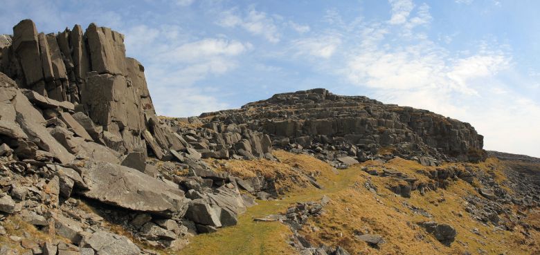
The climbing at this spot is split between a number of small compact buttress which surround the peak, namely the South West Escarpment, the Main Wall, the Minus Seven Wall, the Llyn Du Crag and the Llyn Corn-Yswc Crag. Unless otherwise stated, routes are listed from left to right, and are graded and rated with the aid of the Climbers Club Guide to Meirionnydd, so for full descriptions, please refer to this source. The Climbers’ Club have also produced a free pdf, which provides details of first ascents recorded after 2001: download it here. Technical grades are generally only given to climbs graded adjectivally as Hard Severe (HS) or above. Please be aware that the Rhinog Range is a trad climbing venue and bolting is strictly prohibited. Routes are rated using the British Adjectival Grading System. A conversion table of international climbing grades by SP member Corax is available HERE! Route Symbols:
|


| No. | Name | Length | Pitches | Adjectival Grade | Technical Grade | Quality | Restrictions |
|---|---|---|---|---|---|---|---|
| 1. | Isengard | 18m | 1 | E1 | 5b |  | |
| 2. | Gondor | 9m | 1 | HVS | 5a | | |
| 3. | Osgiliath | 9m | 1 | HVS | 5a | | |
| No. | Name | Length | Pitches | Adjectival Grade | Technical Grade | Quality | Restrictions |
|---|---|---|---|---|---|---|---|
| 4. | Lunarctic | 9m | 1 | HVS | 5a | | |
| 5. | The Day the Wall Came Down | 9m | 1 | VS | 4b | | |
| 6. | Silver Silence | 9m | 1 | S | 4b | | |
| 7. | Don’t Fly Away | 6m | 1 | E1 | 5b | | |
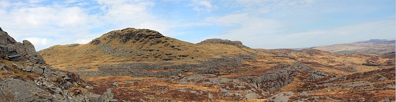
Moel Ysgyfarnod (left) and Foel Penolau (right) (Photo by Nanuls)
| No. | Name | Length | Pitches | Adjectival Grade | Technical Grade | Quality | Restrictions |
|---|---|---|---|---|---|---|---|
| 8. | Done and Rusted | 5m | 1 | VS | 4c | | |
| 9. | Doubtful Digits | 6m | 1 | HVS | 5a | | |
| 10. | Minus Toes | 6m | 1 | HVS | 5a | | |
| 11. | Minus7 | 6m | 1 | E2 | 6a | | |
| 12. | Frigid | 6m | 1 | HVS | 5b | | |
| 13. | Pale Pinkies | 6m | 1 | S | | |
| No. | Name | Length | Pitches | Adjectival Grade | Technical Grade | Quality | Restrictions |
|---|---|---|---|---|---|---|---|
| 14. | Solace | 15m | 1 | VD | | | |
| 15. | Colder Play | 15m | 1 | E2 | 5b | | |


| No. | Name | Length | Pitches | Adjectival Grade | Technical Grade | Quality | Restrictions |
|---|---|---|---|---|---|---|---|
| 16. | Cool Grit | 7m | 1 | E1 | 5b | | |
| 17. | Cross the Threshold of Insanity | 7m | 1 | HVS | 5b | | |
| 18. | Corn of Plenty | 6m | 1 | HVS | 5a | | |
| 19. | Unstuck at Ystwc | 6m | 1 | E1 | 5c | | |
The Miners Track (Photo by Nanuls)
Mountain Conditions
This section displays the mountain conditions for the Snowdonia National Park, of which Moel Ysgyfarnod is a part. Click on the widget for maps and further details. This Snowdonia weather forecast is generated by the Met Office Weather Widget |
When To Climb and Essential Gear
Moel Ysgyfarnod and Foel Penolau can be climbed at anytime of the year, however, in poor conditions the mountain's rock routes are best avoided, particularly if the weather has been wet. March to April offer the most reliable conditions. Of course this all depends on ones ability as a mountaineer/climber, and what might be comfortable for some may seem daunting for others. If your lucky enough to climb the mountains in winter conditions then an ice axe and crampons are essential. |


Getting There
Moel Ysgyfarnod is located in the northern half of the Rhinogydd and is one of the range’s least visited summits. It can be approached from its east via the A470(T), which runs from Dolgellau to Conwy and Colwyn Bay, or the west, via the smaller A496, which runs along the coast from Llanulltyd near Dolgellau and around to Blaenau Ffestiniog in the north. If approaching from the east you will need to leave the A470(T) at the minor junction at Cefn-gallt-y-cwm (SH 710 345) and travel in a westward direction along the southern shores of Llyn Trawsfynydd. A second junction will be reached after around 1.5km (SH 696 347), take the right fork here and continue along the western shore of the lake. Park near Moelfryn-uchaf (SH 684 358) and follow the nearest right of way into the range. Soon the paths will run out and you will have to find your own way. An arguably better approach is from the west, which takes slightly longer to get to. Leave the A470(T) at Maentwrog (SH 665 407) and follow the A496 westwards along the river towards Harlech. After about 10km you’ll reach the junction with the B4573 (SH 606 349). It’s an unusual junction, because rather than turning off onto the B4573 you carry straight on (the turn off is actually for the A470(T)). Continue along the B4573 past the row of houses at Glan-y-Wern until you reach a small stone bridge over a stream. There is a junction at this bridge signposting Eisingrug (SH 615 345); turn off here and follow the minor road to Eisingrug. At Eisingrug take the second minor road on the right (it’s hard to spot, joining the road your on between a field boundary and a stone building), and follow it to its terminus. Here you will find a small grassy parking area and the start of the Miners Track (SH 628 342). There is a payment of £2 to be made for using the car park, which is placed in a box attached to the landowner’s gate. Payments made for parking are donated to the Wales Air Ambulance Service. |
Red Tape and Access
No red tape or access issues here! For climbers, hill walkers and mountaineers, the British Mountaineering Council (BMC) runs a Regional Access Database, which holds mountain/crag specific information on matters of conservation and access, including issues such as nesting restrictions, nature designations and preferred parking. If you are in any doubt about any particular access arrangement, or need to report an incident, you should contact your local BMC Access Representative or the BMC Access Officers for Wales: Elfyn Jones. |


Camping and Accommodation
There’s an almost unlimited supply of accommodation within the Snowdonia National Park so it would be inappropriate to list it all here. For budget accommodation it’s worth checking out some of the following sites: Youth Hostel Association in Wales For more local options, there are a number of campsites that surround the range; Cae Adda (SH 690 355), which is near Llyn Trawsfynydd or Bryn Bwbach (SH 620 368) on the opposite side of the range. |
Maps
|
| Navigation Maps Ordnance Survey 1:25k Explorer Series OL 18 Harlech, Porthmadog & Bala/Y Bala Ordnance Survey 1:50k Landranger Series 124 Porthmadog & Dolgellau Harvey Map Services 1:25k Rhinogs/Rhinogydd Harvey Map Services/BMC 1:40k Snowdonia South Road Maps |
Guidebooks
|
|


External Links
 Foel Penolau (Photo by Nanuls) Foel Penolau (Photo by Nanuls) Moel Ysgyfarnod (Photo by Nanuls) Moel Ysgyfarnod (Photo by Nanuls) Moel Ysgyfarnod (Photo by Nanuls) Moel Ysgyfarnod (Photo by Nanuls) Moel Ysgyfarnod (left) and Foel Penolau (right) (Photo by Nanuls) Moel Ysgyfarnod (left) and Foel Penolau (right) (Photo by Nanuls)Government Bodies and Official Organisations Snowdonia National Park Authority Association of National Park Authorities Royal Commission on Ancient & Historical Monuments in Wales Hiking, Climbing and Mountaineering Organisations and Companies British Mountaineering Council Plas y Brenin National Mountain Centre Weather Tourist Information North Wales Tourism Partnership Local Information from Gwynedd.com Local Information from Snowdonia Wales Net Travel Welsh Public Transport Information Accommodation Youth Hostel Association in Wales Maps and Guidebooks Cordee Travel and Adventure Sports Bookshop Wildlife and Conservation |